Ridge, New York

Last updated

Ridge, New York
Ridge Veterans Memorial (Gateway 2 Pine Barrens).jpg
Welcome to Ridge sign on NY 25 and Ridge Road.
Ridge-ny-map.gif
U.S. Census map
USA New York location map.svg
Red pog.svg
Ridge
Location within the state of New York
Coordinates: 40°54′26″N72°52′58″W / 40.90722°N 72.88278°W / 40.90722; -72.88278
CountryUnited States
StateNew York
County Suffolk
Town Brookhaven
Area
[1]
  Total13.29 sq mi (34.41 km2)
  Land13.19 sq mi (34.17 km2)
  Water0.09 sq mi (0.24 km2)
Elevation
92 ft (28 m)
Population
 (2020)
  Total13,271
  Density1,005.99/sq mi (388.40/km2)
Time zone UTC−05:00 (Eastern Time Zone)
  Summer (DST) UTC−04:00
ZIP Code
11961
Area code(s) 631, 934
FIPS code 36-61665
GNIS feature ID0962492

Ridge is a hamlet and census-designated place (CDP) in the town of Brookhaven, Suffolk County, New York, United States. The population was 13,336 at the 2010 census. [2]

Contents

History

The Longwood Estate

In 1693, William "Tangier" Smith, who owned a homestead in Setauket, was allowed to purchase a large tract of land on the South Shore of Long Island in recognition of his being mayor of Tangier in Africa. The land, called Manor St. George, stretched from the Carmans River (then called the Connecticut River) in the west to the edge of the town of Southampton in the east, with a northern border around present-day New York State Route 25, as much as 81,000 acres (330 km2) of land. He made his manor seat on the South Shore in present-day Mastic, and the northern part, now the south side of Ridge, was called "The Swamp" or "Longswamp". A house wasn't built at Longswamp until after the American Revolution. In 1817, William Sydney Smith inhabited the house and changed the name to Longwood.

In 1955, what then remained of William Smith's original manor was primarily located in Ridge and was surrounded by the world growing up around it, in the form of the Brookhaven National Laboratory and the surrounding areas becoming increasingly populated. Longwood's 750 acres (300 ha) fell into the hands of Elbert Clayton Smith, who immediately moved his family from California to live there. He seems to have been very generous to his new community; his donations included 51 acres (21 ha) to the school board for the construction of Longwood High School and 6 acres (2.4 ha) to Middle Island Presbyterian Church. In 1967, Elbert Smith died, and the Longwood Estate was carved into housing developments and nearly destroyed until enough noise was made about preservation to have the house and 35 acres (14 ha) of land given to the Town of Brookhaven in 1974. The Smith Estate was added to the National Register of Historic Places in 1981. [3]

Randallville

In 1738, northern Ridge was settled by widower Samuel Randall of North Stonington, Connecticut; his only son Stephen Randall and his descendants farmed a 4,000-acre (1,600 ha) plot of ground that Samuel had always referred to as "the Ridge" based on the geographical terrain. First called "Randallville", Ridge was the name selected by its residents for postal delivery. The Randall burial plot near the William Floyd Parkway includes the grave of Lt. Stephen Randall (1736–1818), patriot of the American Revolution and a Suffolk County Militia veteran of the Battle of Long Island. Graves of Randall's wife Elizabeth Swezey (1747–1834) and several descendants are also within the plot.

Geography

Ridge is located at the northwestern end of the Long Island Central Pine Barrens and is referred to by a sign in the center of the hamlet as the "Gateway to the Pine Barrens". [4]

According to the United States Census Bureau, the CDP has a total area of 13.3 square miles (34.5 km2), of which 13.2 square miles (34.2 km2) is land and 0.077 square miles (0.2 km2), or 0.70%, is water. [2]

Historical population
CensusPop.Note
2020 13,271
U.S. Decennial Census [5]

Demographics

As of the census [6] of 2000, there were 13,380 people, 5,545 households, and 3,476 families residing in the CDP. The population density was 993.6 inhabitants per square mile (383.6/km2). There were 5,922 housing units at an average density of 439.8 per square mile (169.8/km2). The racial makeup of the CDP was 92.99% White, 3.45% African American, 0.28% Native American, 0.90% Asian, 0.03% Pacific Islander, 0.75% from other races, and 1.59% from two or more races. Hispanic or Latino of any race were 3.51% of the population.

There were 5,545 households, out of which 27.4% had children under the age of 18 living with them, 52.9% were married couples living together, 7.5% had a female householder with no husband present, and 37.3% were non-families. 34.4% of all households were made up of individuals, and 28.5% had someone living alone who was 65 years of age or older. The average household size was 2.38 and the average family size was 3.09.

In the CDP, the population was spread out, with 23.2% under the age of 18, 5.4% from 18 to 24, 24.5% from 25 to 44, 17.8% from 45 to 64, and 29.1% who were 65 years of age or older. The median age was 43 years. For every 100 females, there were 82.9 males. For every 100 females age 18 and over, there were 76.9 males.

The median income for a household in the CDP was $44,140, and the median income for a family was $60,039. Males had a median income of $49,539 versus $31,384 for females. The per capita income for the CDP was $23,387. About 4.4% of families and 6.5% of the population were below the poverty threshold, including 7.5% of those under age 18 and 6.0% of those age 65 or over.

Education

Ridge is served by the Longwood Central School District, which at 58 square miles (150 km2) is the largest school district on Long Island.

Media

Related Research Articles

Saybrook Manor is a community and census-designated place (CDP) in Old Saybrook, a town in Middlesex County, Connecticut, United States. The population was 1,127 at the 2020 census. The Saybrook Manor section is generally the area south of U.S. Route 1 between the Westbrook town line and the Oyster River.

<span class="mw-page-title-main">Ridge Manor, Florida</span> Census-designated place in Florida, United States

Ridge Manor is a census-designated place (CDP) in Hernando County, Florida, United States. The population was 4,513 at the 2010 census.

<span class="mw-page-title-main">Heathrow, Florida</span> CDP in Florida, United States

Heathrow is a census-designated place and an unincorporated suburban community in Seminole County, Florida, United States. Heathrow is on the I-4 Corridor in Central Florida, 19 miles northeast of Orlando and 38 miles southwest of Daytona Beach. Heathrow comprises a master-planned, private gated residential community of approximately 2,200 homes, and the Heathrow International Business Center, an office park. Heathrow was founded in 1985 by Jeno Paulucci, a food business entrepreneur. The area had been a source of celery used in making his Chun King Foods American Chinese style food. The population was 4,068 at the 2000 census. Heathrow is home to the national headquarters of the American Automobile Association (AAA).

<span class="mw-page-title-main">Coram, New York</span> Hamlet and census-designated place in New York, United States

Coram is a hamlet and census-designated place in the town of Brookhaven, Suffolk County, Long Island, New York, United States. As of the 2010 United States census, the CDP population was 39,113.

<span class="mw-page-title-main">East Moriches, New York</span> Hamlet and census-designated place in New York, United States

East Moriches is a hamlet and census-designated place in the Town of Brookhaven, Suffolk County, New York, United States. The population was 5,249 at the 2010 census.

<span class="mw-page-title-main">East Patchogue, New York</span> Census-designated place in New York, United States

East Patchogue is a census-designated place (CDP) in the Town of Brookhaven in Suffolk County, on the South Shore of Long Island, in New York, United States. The population was 22,469 at the 2010 census. The CDP is a proximate representation of the East Patchogue hamlet used for statistical purposes of the Census Bureau.

<span class="mw-page-title-main">East Shoreham, New York</span> Hamlet and census-designated place in New York, United States

East Shoreham is a hamlet and census-designated place (CDP) in the Suffolk County town of Brookhaven, New York, United States. The population was 6,841 at the 2020 census.

<span class="mw-page-title-main">Eastport, New York</span> Hamlet and census-designated place in New York, United States

Eastport is a hamlet and census-designated place (CDP) in Suffolk County, New York, on the South Shore of Long Island. The population was 1,831 at the 2010 census.

<span class="mw-page-title-main">Gordon Heights, New York</span> Hamlet and census-designated place in New York, United States

Gordon Heights is a hamlet and census-designated place (CDP) in the Town of Brookhaven, Suffolk County, Long Island, New York, United States. The population was 3,981 at the 2020 census.

<span class="mw-page-title-main">Manorville, New York</span> Hamlet and census-designated place in New York, United States

Manorville is a hamlet and census-designated place (CDP) in Suffolk County, New York, United States. The population was 14,314 at the 2010 census.

<span class="mw-page-title-main">Mastic, New York</span> Hamlet and census-designated place in New York, United States

Mastic is a hamlet and a census-designated place (CDP) in the southeastern part of the town of Brookhaven in central Suffolk County, New York, United States. The population was 15,481 at the 2010 census.

<span class="mw-page-title-main">Mastic Beach, New York</span> Hamlet and Census-designated place in New York, United States

Mastic Beach is a hamlet and census-designated place, and former village in the southeastern part of the Town of Brookhaven in Suffolk County, on Long Island, in New York, United States. The population was 14,849 at the 2010 census, when it was an unincorporated census-designated place for the first time.

<span class="mw-page-title-main">Medford, New York</span> Hamlet & census-designated place in New York, United States

Medford is a hamlet and census-designated place (CDP) in the Town of Brookhaven in Suffolk County, on Long Island, in New York, United States. The population was 24,142 at the 2010 census.

<span class="mw-page-title-main">Middle Island, New York</span> Hamlet and census-designated place in New York, United States

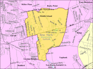
Middle Island is a hamlet and census-designated place (CDP) in the Town of Brookhaven, Suffolk County, New York, United States. The population was 10,483 at the 2010 census. It is situated between the hamlets of Coram and Ridge, to the west and east, respectively, and Rocky Point and Yaphank to the north and south. The name derives from the fact that it lies approximately halfway between the eastern and western ends of Long Island as well as halfway between the northern and southern boundaries.

<span class="mw-page-title-main">Moriches, New York</span> Hamlet and census-designated place in New York, United States

Moriches is a hamlet and census-designated place (CDP) in the Suffolk County town of Brookhaven, New York, United States. The population was 2,838 at the 2010 census.

<span class="mw-page-title-main">Shirley, New York</span> Hamlet and census-designated place in New York, United States

Shirley is a hamlet in Suffolk County, New York, United States. At the 2010 census, the population of Shirley was 27,854. Shirley is the western terminus of Atlantic Crossing 1, a major submarine telecommunications cable linking the United States with the UK, Germany, and the Netherlands. Soon, the Emerald Express transatlantic communications cable will provide data connectivity between Europe and North America, landing in Shirley.

<span class="mw-page-title-main">Yaphank, New York</span> Hamlet and census-designated place in New York, United States

Yaphank is a hamlet and census-designated place (CDP) in Suffolk County, New York, United States. The population was 5,945 at the time of the 2010 census.

<span class="mw-page-title-main">Brookhaven, West Virginia</span> CDP in West Virginia

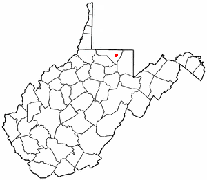
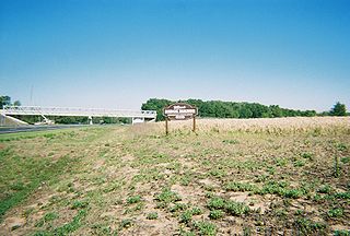
Brookhaven is a census-designated place (CDP) in Monongalia County, West Virginia, United States. The population was 5,707 at the 2020 census. It is included in the Morgantown, West Virginia Metropolitan Statistical Area.

<span class="mw-page-title-main">Brookhaven (CDP), New York</span> Hamlet and census-designated place in New York, United States

Brookhaven is a hamlet and census-designated place in Brookhaven Town, Suffolk County, New York, United States. The population was 3,451 at the 2010 census.

<span class="mw-page-title-main">Manor St. George</span>

Manor St. George or St. George's Manor was a large tract of land purchased by William "Tangier" Smith in the 17th century on Long Island, in central Suffolk County, New York. Parts of the original parcel, which was approximately 64,000 acres (260 km2) of land, are preserved in bits and pieces: 127 acres (0.51 km2) and the main house and buildings are called the Manor of St. George and located in Shirley; 35 acres (0.14 km2) and another house are called the Longwood Estate and located in Ridge; and 35 acres (0.14 km2) became part of the William Floyd Estate.

References

  1. "ArcGIS REST Services Directory". United States Census Bureau. Retrieved September 20, 2022.
  2. 1 2 "Geographic Identifiers: 2010 Demographic Profile Data (G001): Ridge CDP, New York". U.S. Census Bureau, American Factfinder. Archived from the original on February 12, 2020. Retrieved January 8, 2013.
  3. "National Register Information System". National Register of Historic Places . National Park Service. March 13, 2009.
  4. "US Gazetteer files: 2010, 2000, and 1990". United States Census Bureau. February 12, 2011. Retrieved April 23, 2011.
  5. "Census of Population and Housing". Census.gov. Retrieved June 4, 2016.
  6. "U.S. Census website". United States Census Bureau . Retrieved January 31, 2008.