South Haven, New York

Last updated

South Haven
South Haven Cemetery NYS Historical Marker.JPG
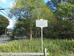
Plaque for the historic South Haven Presbyterian Church Cemetery just off of Montauk Highway
USA New York location map.svg
Red pog.svg
South Haven
Location within the state of New York
Coordinates: 40°47′57.5″N72°53′42″W / 40.799306°N 72.89500°W / 40.799306; -72.89500
Country Flag of the United States.svg  United States
State Flag of New York.svg  New York
County Suffolk
Town Brookhaven
Time zone UTC-5 (Eastern (EST))
  Summer (DST) UTC-4 (EDT)
ZIP codes
11719
Area code(s) 631, 934

South Haven is a hamlet in Suffolk County, New York, United States, on the south shore of Long Island.

Contents

South Haven is part of the Town of Brookhaven, and is not to be confused with the hamlet of Brookhaven, with which it shares a ZIP Code. [1]

History

South Haven was the shortened form of the original name of the hamlet: South Brookhaven.[ citation needed ]

Geography

South Haven is dominated by two large parcels of parkland: South Haven County Park, and the Wertheim National Wildlife Refuge. [2]

Element One made a progressive trance song called "South Haven" in 2009. [3]

Related Research Articles

<span class="mw-page-title-main">Suffolk County, New York</span> County in New York, United States

Suffolk County is the easternmost county in the U.S. state of New York. It comprises the eastern two-thirds of Long Island, bordered to its west by Nassau County, to its east by Gardiners Bay and the Atlantic Ocean, to its north by Long Island Sound, and to its south by Great South Bay.

<span class="mw-page-title-main">Bellport, New York</span> Village in New York, United States

Bellport is a village in the Town of Brookhaven in Suffolk County, on the South Shore of Long Island, in New York, United States. The population was 2,084 at the 2010 census.

<span class="mw-page-title-main">East Patchogue, New York</span> Census-designated place in New York, United States

East Patchogue is a census-designated place (CDP) in the Town of Brookhaven in Suffolk County, on the South Shore of Long Island, in New York, United States. The population was 22,469 at the 2010 census. The CDP is a proximate representation of the East Patchogue hamlet used for statistical purposes of the Census Bureau.

<span class="mw-page-title-main">Manorville, New York</span> Hamlet and census-designated place in New York, United States

Manorville is a hamlet and census-designated place (CDP) in Suffolk County, New York, United States. The population was 14,314 at the 2010 census.

<span class="mw-page-title-main">Mastic Beach, New York</span> Hamlet and Census-designated place in New York, United States

Mastic Beach is a hamlet and census-designated place, and former village in the southeastern part of the Town of Brookhaven in Suffolk County, on Long Island, in New York, United States. The population was 14,849 at the 2010 census, when it was an unincorporated census-designated place for the first time.

<span class="mw-page-title-main">Middle Island, New York</span> Hamlet and census-designated place in New York, United States

Middle Island is a hamlet and census-designated place (CDP) in the Town of Brookhaven, Suffolk County, New York, United States. The population was 10,483 at the 2010 census. It is situated between the hamlets of Coram and Ridge, to the west and east, respectively, and Rocky Point and Yaphank to the north and south. The name derives from the fact that it lies approximately halfway between the eastern and western ends of Long Island as well as halfway between the northern and southern boundaries.

<span class="mw-page-title-main">Port Jefferson Station, New York</span> Hamlet & census-designated place in New York, United States

Port Jefferson Station is a hamlet and census-designated place (CDP) in the Town of Brookhaven, in Suffolk County, in New York, United States. The population was 7,838 as of the 2010 census.

<span class="mw-page-title-main">Islip, New York</span> Town in New York, United States

Islip is a town in Suffolk County, New York, United States, on the South Shore of Long Island. The population was 335,543 at the 2010 census, making it the fourth most populous city or town in the New York metropolitan area.

<span class="mw-page-title-main">Riverhead, New York</span> Town in New York, United States

Riverhead is a town in Suffolk County, New York, United States, on the north shore of Long Island. Since 1727, Riverhead has been the county seat of Suffolk County, though most county offices are in Hauppauge. As of the 2020 census, the population was 35,902. The town rests on the mouth of the Peconic River, from which it derives its name. The smaller hamlet of Riverhead lies within it, and is the town's principal economic center. The town is 166 miles (267 km) southwest of Boston via the Orient Point-New London Ferry, and is 76 miles (123 km) northeast of New York City.

<span class="mw-page-title-main">Brookhaven, New York</span> 2nd most populated town in New York, United States

Brookhaven, formally the Town of Brookhaven, is a large suburban town in Suffolk County, Long Island, New York. With a population of 488,497 as of 2022, it is the second most populous town in the United States and in New York and the third most populous community in the state.

<span class="mw-page-title-main">Upton, New York</span> Hamlet and census-designated place in New York, United States

Upton is a hamlet and census-designated place (CDP) on Long Island in the town of Brookhaven. It is the home of the Brookhaven National Laboratory and a National Weather Service weather forecast office.

<span class="mw-page-title-main">East Setauket, New York</span> Census-designated place in New York, United States

East Setauket is a hamlet and census-designated place (CDP) on Long Island, in the town of Brookhaven, Suffolk County, New York, United States. It was first listed as a CDP prior to the 2020 census. Before that it was part of the Setauket-East Setauket CDP.

<span class="mw-page-title-main">New York's 1st congressional district</span> U.S. House district for New York

New York's 1st congressional district is a congressional district for the United States House of Representatives in eastern Long Island. It includes the eastern two-thirds of Suffolk County, including the northern portion of Brookhaven, as well as the entirety of the towns of Huntington, Smithtown, Riverhead, Southold, Southampton, East Hampton, and Shelter Island. The district encompasses extremely wealthy enclaves such as the Hamptons, middle class suburban towns such as Selden, Centereach, and Lake Grove, working-class towns such as Riverhead and rural farming communities such as Mattituck and Jamesport on the North Fork. The district currently is represented by Republican Nick LaLota who lives in Amityville, outside of the district.

<span class="mw-page-title-main">Davis Park, New York</span> Hamlet in New York, United States

Davis Park is a hamlet in the Town of Brookhaven, Suffolk County, New York, United States. It is located on Fire Island, a barrier island separated from the southern side of Long Island by the Great South Bay off the South Shore village of Patchogue. It lies within the Fire Island National Seashore.

<span class="mw-page-title-main">Strongs Neck, New York</span> Hamlet and peninsula in New York, US

Strongs Neck is a hamlet and peninsula just south of Long Island Sound and hamlet in Suffolk County, New York, United States, on the North Shore of Long Island.

<span class="mw-page-title-main">County Route 16 (Suffolk County, New York)</span> Road in Suffolk County, New York, US

County Route 16 (CR 16) is a main thoroughfare through central Suffolk County, New York, in the United States. Its western terminus is at Middle Country Road in Village of the Branch, and its eastern terminus is at Montauk Highway (CR 80) in Brookhaven. The route carries five different names along its length: Terry Road, Smithtown Boulevard, Lake Shore Road, Portion Road, and Horseblock Road.

<span class="mw-page-title-main">County Route 83 (Suffolk County, New York)</span> County road in Suffolk County, New York, US

County Route 83 (CR 83) is a major north–south county road in Suffolk County, New York, in the United States. It runs from New York State Route 27 exit 52A in North Patchogue to NY 25A in Mount Sinai. The road was to have to run further south along North Ocean Avenue and South Ocean Avenue through the village of Patchogue, but that proposal was canceled. CR 83 is known as North Ocean Avenue south of Granny Road in Medford and as Patchogue–Mount Sinai Road north of that point.

<span class="mw-page-title-main">County Route 46 (Suffolk County, New York)</span> County road in Suffolk County, New York, US

County Route 46 (CR 46) is a major county road in eastern Suffolk County, New York, in the United States. It runs south-to-north from CR 75 in Smith Point County Park to New York State Route 25A (NY 25A) near the border of Shoreham and Wading River. The road is known as the William Floyd Parkway along its entire length, and is named after William Floyd, a Long Island native and a signer of the United States Declaration of Independence. Despite its "parkway" designation within the State of New York, the road is open to commercial vehicles.

The South Country Central School District is a district of approximately 16 square miles (41 km2) located in southern Brookhaven Town, in Suffolk County, New York, United States. It primarily serves the Village of Bellport and the Hamlets of North Bellport and Brookhaven. It also serves small parts of East Patchogue, Yaphank, and Medford.

References

  1. "US Gazetteer files: 2010, 2000, and 1990". United States Census Bureau. February 12, 2011. Retrieved April 23, 2011.
  2. "Long Island Index: Interactive Map". www.longislandindexmaps.org. Retrieved August 3, 2021.
  3. Element One – South Haven / International Language (Discogs)

Commons-logo.svg Media related to South Haven, New York at Wikimedia Commons