
Suffolk County is the easternmost county in the U.S. state of New York, constituting the eastern two-thirds of Long Island. It is bordered to its west by Nassau County, to its east by Gardiners Bay and the open Atlantic Ocean, to its north by Long Island Sound, and to its south by the Atlantic Ocean.
Centereach is a hamlet and census-designated place in Suffolk County, New York, United States. The population was 31,578 at the 2010 census.

Miller Place is a hamlet and census-designated place (CDP) in the Town of Brookhaven, Suffolk County, New York, United States. Despite preserving much of its historic identity, changes in the 20th century have transitioned the hamlet into a desirable and densely populated suburban area. The population was 11,723 at the 2020 census.

Mount Sinai is a hamlet and census-designated place (CDP) located within the Town of Brookhaven, in Suffolk County, New York, United States. The population was 12,118 at the 2010 census. The hamlet is located on the North Shore of Long Island.

Port Jefferson, also known as Port Jeff, is an incorporated village in the town of Brookhaven in Suffolk County, New York, on the North Shore of Long Island. Officially known as the Incorporated Village of Port Jefferson, the population was 7,962 as of the 2020 United States census.

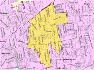
Port Jefferson Station is a hamlet and census-designated place (CDP) in the Town of Brookhaven, in Suffolk County, in New York, United States. The population was 7,838 as of the 2010 census.

Ridge is a hamlet and census-designated place (CDP) in the town of Brookhaven, Suffolk County, New York, United States. The population was 13,336 at the 2010 census.

Selden is a hamlet and census-designated place (CDP) in the Town of Brookhaven in Suffolk County, New York, United States. The population was 21,262 at the time of the 2020 census.
Setauket is a hamlet and census-designated place (CDP) in the Town of Brookhaven, Suffolk County, New York, United States, on the North Shore of Long Island. As of the 2010 United States census, the CDP population, which at the time included East Setauket as well, was 15,477.

St. James is a hamlet and census-designated place (CDP) in Suffolk County, New York, United States. The population of the CDP was 13,487 at the 2020 census. St. James is part of the Town of Smithtown and is located on the North Shore of Long Island. The ZIP code is 11780.

Stony Brook is a hamlet and census-designated place (CDP) in the Town of Brookhaven in Suffolk County, New York, United States, on the North Shore of Long Island. Begun in the colonial era as an agricultural enclave, the hamlet experienced growth first as a resort town and then to its current state as one of Long Island's major tourist towns and centers of education. Despite being referred to as a village by residents and tourists alike, Stony Brook has never been legally incorporated by the state. The population was 13,740 at the 2010 census.

Brookhaven is a large suburban town in Suffolk County, Long Island, New York. With a population of 488,497 as of 2022, it is the second most populous town in the United States and in New York and the third most populous community in the state.

New York State Route 25A (NY 25A) is a state highway on Long Island in New York, United States. It serves as the main east–west route for most of the North Shore of Long Island, running for 73 miles (117 km) from Interstate 495 (I-495) at the Queens–Midtown Tunnel in the New York City borough of Queens to NY 25 in Calverton, Suffolk County. The highway is a northern alternate route of NY 25, which follows a more inland routing along Jericho Turnpike.

New York State Route 112 (NY 112) is a state highway located entirely within the town of Brookhaven in Suffolk County, New York, in the United States. It runs from an intersection with East Main Street in the village of Patchogue to a junction with NY 25A in Port Jefferson Station. It is known locally as Medford Avenue in Patchogue and Patchogue Road in Terryville and Port Jefferson Station. The official name for the road outside these areas is "Patchogue–Port Jefferson Road", though it is often signed simply as "Route 112".

New York's 1st congressional district is a congressional district for the United States House of Representatives in eastern Long Island. It includes the eastern two-thirds of Suffolk County, including the northern portion of Brookhaven, as well as the entirety of the towns of Huntington, Smithtown, Riverhead, Southold, Southampton, East Hampton, and Shelter Island. The district encompasses extremely wealthy enclaves such as the Hamptons, middle class suburban towns such as Selden, Centereach, and Lake Grove, working-class towns such as Riverhead and rural farming communities such as Mattituck and Jamesport on the North Fork. The district currently is represented by Republican Nick LaLota.

Three Village Central School District is a school district located on Long Island, New York. It serves Setauket, East Setauket, Stony Brook, Poquott, Head of the Harbor, Old Field, and small portions of Port Jefferson, Saint James, South Setauket, and Lake Grove. Its name came from the older, original "Three Villages" of Setauket, Stony Brook and Old Field after the merger of the Stony Brook and Setauket school districts in the 1960s. Ward Melville, a local philanthropist, was a proponent of the Three Village school district, and contributed land for its new schools.

Times Beacon Record Newspapers is a community newspaper publisher, located in Setauket, NY, consisting of seven different weekly newspapers serving Suffolk County localities on the North Shore of Long Island spanning from the town of Huntington into Wading River. The current publisher is Leah S. Dunaief.
Bicycle Path is a historic road in the Town of Brookhaven in Suffolk County, on Long Island, New York, United States. It was built in the late 19th century in order to capitalize on the bicycle craze of that period. It ran north and south from Patchogue to just east of Port Jefferson, lying mostly west of New York State Route 112, crossing it at Port Jefferson Road in Port Jefferson Station.


