Deer Park, New York | |
---|---|
Coordinates: 40°45′42″N73°19′45″W / 40.76167°N 73.32917°W | |
Country | United States |
State | New York |
County | Suffolk |
Town | Babylon |
Area | |
• Total | 6.17 sq mi (15.99 km2) |
• Land | 6.17 sq mi (15.98 km2) |
• Water | 0.00 sq mi (0.01 km2) |
Elevation | 74 ft (23 m) |
Population (2020) | |
• Total | 28,837 |
• Density | 4,674.50/sq mi (1,804.97/km2) |
Time zone | UTC-5 (Eastern (EST)) |
• Summer (DST) | UTC-4 (EDT) |
ZIP code | 11729 |
Area codes | 631, 934 |
FIPS code | 36-19972 |
GNIS feature ID | 0948210 |
Deer Park is a hamlet and census-designated place (CDP) in the Town of Babylon, in Suffolk County, on Long Island, in New York, United States. The population was 27,745 at the 2010 census. [2]
Deer Park is located in the pine barrens in the northeastern corner of the town of Babylon. It grew out of Jacob Conklin's 1610 settlement of the Half Way Hollow Hills, later known as Wheatley Heights. Charles Wilson started what is now Deer Park in 1853 about eleven years after the Long Island Rail Road arrived in 1842-when he established a large and productive farm. A post office was opened in 1851, closed in 1872 and re-opened on July 1, 1873. Deer Park had an elementary school in 1874. Prior to 1923, the Deer Park School District took in Deer Park and Wyandanch. [3]
Farming was a staple of this small town for most of its history. Known as the "fruit basket" of New York state, the area was also famed for its dahlia cultivation. It was not until the effects of the post-World War II boom reached Deer Park that its economy ceased to be agricultural.
Deer Park had two industries before 1940: the Walker and Conklin firm baked red bricks in West Deer Park (now Wheatley Heights), and the Golden Pickle Works (1902) prepared pickles in Deer Park. Deer Park was the locale of the Edgewood State Hospital (1938–1969)-originally a tuberculosis sanatorium, and later an Army hospital during World War II. The Fairchild Engine and Airplane Corporation established a factory in Deer Park in 1956. [4]
In 1946, the former Deer Park Airport opened. It operated until 1974; the land was subsequently redeveloped. [5]
Deer Park is reputed to have been the favorite summer spot of President John Quincy Adams, as his preferred vacation destination from 1835 until his death. However, this "fact" has never been verified. [4] [6]
On October 22, 2008, the $300 million 
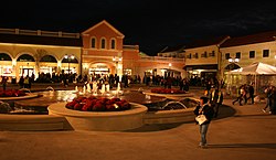
Tanger Outlets at the Arches shopping mall opened. [7]
According to the United States Census Bureau, the CDP has a total area of 6.2 square miles (16.0 km2), all land.
Deer Park is located in the northeastern corner of the town of Babylon. [8] It is bordered to the west by the Babylon hamlets of Wyandanch and Wheatley Heights, to the north by Dix Hills in the Town of Huntington, to the east by Brentwood and Baywood in the town of Islip, and to the south by the hamlet of North Babylon.
Census | Pop. | Note | %± |
---|---|---|---|
2020 | 28,837 | — | |
U.S. Decennial Census [9] |
In 2021, Deer Park, NY had a population of 26.8k people with a median age of 42.9 and a median household income of $114,230. Between 2020 and 2021 the population of Deer Park, NY grew from 26,043 to 26,803, a 2.92% increase and its median household income grew from $106,111 to $114,230, a 7.65% increase.
The 5 largest ethnic groups in Deer Park, NY are White (Non-Hispanic) (58.9%), Asian (Non-Hispanic) (10.4%), Black or African American (Non-Hispanic) (9.82%), White (Hispanic) (9.05%), and Two+ (Hispanic) (4.05%).
None of the households in Deer Park, NY reported speaking a non-English language at home as their primary shared language. This does not consider the potential multi-lingual nature of households, but only the primary self-reported language spoken by all members of the household.
95.1% of the residents in Deer Park, NY are U.S. citizens.
In 2021, the median property value in Deer Park, NY was $411,900, and the homeownership rate was 85.3%. [10]
As of 2020, the population was 28,837. The demographics were as follows: [11]
Albertson is a hamlet and census-designated place (CDP) in the Town of North Hempstead in Nassau County, on Long Island, in New York, United States. The population was 5,220 at the time of the 2020 census.
Greenvale is a hamlet and census-designated place (CDP) in the towns of North Hempstead and Oyster Bay in Nassau County, on the North Shore of Long Island, in New York, United States. It is considered part of the Greater Roslyn area, which is anchored by the Incorporated Village of Roslyn. The population was 1,069 at the time of the 2020 census.
Harbor Isle is a hamlet and census-designated place (CDP) in the Town of Hempstead in Nassau County, New York, United States. The population was 1,301 at the 2010 census.
Herricks is a hamlet and census-designated place (CDP) in Nassau County, on Long Island, in New York, United States. The population was 4,398 at the 2020 census.
North New Hyde Park is a hamlet and census-designated place (CDP) in the Town of North Hempstead in Nassau County, on Long Island, in New York, United States. The population was 15,657 at the 2020 census.
Roslyn Heights is a hamlet and census-designated place (CDP) in the Town of North Hempstead in Nassau County, on the North Shore of Long Island, in New York, United States. It is considered part of the Greater Roslyn area, which is anchored by the Incorporated Village of Roslyn. The population was 6,747 at the time of the 2020 census.
Baywood is a hamlet and census-designated place (CDP) in the Town of Islip in Suffolk County, on Long Island, in New York, United States. The population was 7,350 at the 2010 census.
East Farmingdale is a hamlet and a census-designated place (CDP) located in the Town of Babylon in Suffolk County, on the South Shore of Long Island, in New York, United States. The population was 6,617 at the time of the 2020 census.
Holtsville is a hamlet and census-designated place (CDP) in Suffolk County, on Long Island, in New York, United States. The population was 19,714 at the 2010 census.
Melville is an affluent hamlet and census-designated place (CDP) in Huntington in Suffolk County on Long Island, New York. The population was 19,284 at the 2020 census.
North Babylon is a hamlet and census-designated place (CDP) located in the Town of Babylon in Suffolk County, on the South Shore of Long Island, in New York, United States. The population was 17,509 at the 2010 census.
North Bay Shore is a hamlet and census-designated place on Long Island in the Town of Islip in Suffolk County, New York, United States. The population was 18,944 as of the 2010 census. The hamlet is a suburb of New York City.
South Huntington is an affluent hamlet and census-designated place (CDP) within the Town of Huntington in Suffolk County, on Long Island, in New York, United States. The population was 9,422 at the 2010 census. Residents have a Huntington Station postal address. South Huntington is considered part of the greater Huntington area, which is anchored by Huntington.
West Babylon is a census-designated place (CDP) in the Town of Babylon in Suffolk County, New York, United States. The population was 43,213 at the 2010 census.
West Islip is a hamlet and CDP founded in 1683, located in the Town of Islip, in Suffolk County, New York, United States. Situated on the South Shore of Long Island, the population of the CDP was 27,048 at the time of the 2020 census.
Wheatley Heights is a census-designated place (CDP) in Suffolk County, New York. The population was 5,130 at the 2010 census. The CDP, located in the Town of Babylon, is named after the hamlet in the same general vicinity.
Wyandanch is a hamlet and census-designated place (CDP) in the Town of Babylon in Suffolk County, New York. The population was 12,990 at the 2020 census.
The Town of Babylon is one of ten towns in Suffolk County, New York, United States. Its population was 218,223 as of the 2020 census. Parts of Jones Beach Island, Captree Island and Fire Island are in the southernmost part of the town. It borders Nassau County to the west and the Atlantic Ocean to the south. At its westernmost point, it is about 20 miles (32 km) from New York City at the Queens border, and about 30 miles (48 km) from Manhattan. The village of Babylon is also within the town.
New York's 2nd congressional district is a congressional district for the United States House of Representatives along the South Shore of Long Island, New York. It includes southwestern Suffolk County and a small portion of southeastern Nassau County. The district is currently represented by Republican Andrew Garbarino.
Half Hollow Hills is a large hamlet in the Towns of Babylon and Huntington in Suffolk County, Long Island, New York, United States.