Gilgo-Oak Beach-Captree, New York

Last updated
Gilgo-Oak Beach-Captree, New York
Gilgo-ny-map.gif
U.S. Census Map
USA New York location map.svg
Red pog.svg
Location within the state of New York
Coordinates: 40°38′28″N73°16′42″W / 40.64111°N 73.27833°W / 40.64111; -73.27833 Coordinates: 40°38′28″N73°16′42″W / 40.64111°N 73.27833°W / 40.64111; -73.27833
Country United States
State New York
County Suffolk
Area
  Total3.6 sq mi (9.4 km2)
  Land2.7 sq mi (7.1 km2)
  Water0.9 sq mi (2.4 km2)
Population
 (2000)
  Total333
  Density122.1/sq mi (47.2/km2)
Time zone UTC-5 (Eastern (EST))
  Summer (DST) UTC-4 (EDT)
FIPS code 36-28997

Gilgo-Oak Beach-Captree, frequently just called Oak Beach, was a census-designated place (CDP) in Suffolk County, New York within the Town of Babylon. The population was 333 at the 2000 census.

Contents

Following the 2010 census, the area was delineated as two CDPs: Gilgo and Oak Beach–Captree. The original CDP contained several small beach communities on a barrier island along the southern edge of Long Island. In order from west to east, these included West Gilgo Beach (on the Nassau/Suffolk county border), Gilgo Beach, Cedar Beach (no residences), Oak Beach (including the Oak Island Beach Association), Oak Island and Captree Island. They are connected to the mainland by Ocean Parkway from the west and Robert Moses State Parkway from the north.

Prior to the 2020 census, the Oak Beach-Captree CDP was further split into the Oak Beach and Captree CDPs.

Geography

Oak Beach is located at 40°38′28″N73°16′42″W / 40.64111°N 73.27833°W / 40.64111; -73.27833 (40.641100, -73.278195). [1]

According to the United States Census Bureau, the CDP had a total area of 3.7 square miles (9.6 km2), of which 2.7 square miles (7.0 km2) was land and 0.9 square miles (2.3 km2), or 25.21%, is water.

Demographics

As of the census [2] of 2000, there were 333 people, 161 households, and 94 families residing in the CDP. The population density was 122.1 per square mile (47.1/km2). There were 305 housing units at an average density of 111.9/sq mi (43.1/km2). The racial makeup of the CDP was 97.00% White, 0.30% African American and 2.70% Asian. Hispanic or Latino of any race were 1.80% of the population.

There were 161 households, out of which 14.9% had children under the age of 18 living with them, 50.9% were married couples living together, 6.2% had a female householder with no husband present, and 41.0% were non-families. 34.8% of all households were made up of individuals, and 11.8% had someone living alone who was 65 years of age or older. The average household size was 2.07 and the average family size was 2.64.

In the CDP, the population was spread out, with 13.5% under the age of 18, 1.5% from 18 to 24, 28.8% from 25 to 44, 34.8% from 45 to 64, and 21.3% who were 65 years of age or older. The median age was 48 years. For every 100 females, there were 109.4 males. For every 100 females age 18 and over, there were 100.0 males.

The median income for a household in the CDP was $66,250, and the median income for a family was $105,870. Males had a median income of $61,250 versus $37,083 for females. The per capita income for the CDP was $55,813. None of the families and 0.9% of the population were living below the poverty line, including no under eighteens and none of those over 64.

The census numbers are presumably for full-time inhabitants; many of these houses are second homes and not primary residences, although the proportion of seasonal residents is decreasing.

The land for these communities is not privately owned, but leased from the State of New York through the year 2050. However, the residences on the property are owned. If the leases are not renewed at some point in the future, the owners will have to move the houses elsewhere, similar to what happened at High Hill Beach when Jones Beach was created.

Related Research Articles

Peeples Valley, Arizona CDP in Yavapai County, Arizona

Peeples Valley is a census-designated place (CDP) in Yavapai County, Arizona, United States. The population was 374 at the 2000 census.

Westbrook, Connecticut Town in Connecticut, United States

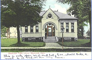
Westbrook is a town in Middlesex County, Connecticut, United States. The population was 6,938 at the 2010 census. The town center is classified by the U.S. Census Bureau as a census-designated place (CDP).

Kawela Bay, Hawaii Census-designated place in Hawaii, United States

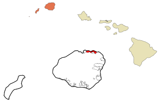
Kawela Bay is a census-designated place and small community in the Koʻolauloa District on the northern coast of the island of Oʻahu, City & County of Honolulu, Hawaii, United States. In Hawaiian, ka wela means "the heat". As of the 2010 Census, the CDP had a population of 330.

Kalihiwai, Hawaii Census-designated place in Hawaii, United States

Kalihiwai is a census-designated place (CDP) in Kauaʻi County, Hawaiʻi, United States. The population was 428 at the 2010 census.

Lake Michigan Beach, Michigan Census-designated place & unincorporated community in Michigan, United States

Lake Michigan Beach is an unincorporated community in Berrien County in the U.S. state of Michigan. It is a census-designated place (CDP) for statistical purposes, without any legal status as a municipality. The population was 1,216 at the 2010 census.

Black Eagle, Montana CDP in Montana, United States

Black Eagle is a census-designated place (CDP) in Cascade County, Montana, United States. The population was 904 at the 2010 census. It is a suburb of Great Falls.

Red Oaks Mill, New York Census-designated place in New York, United States

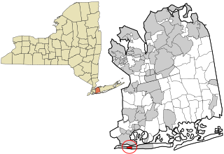
Red Oaks Mill is a hamlet and census-designated place (CDP) in Dutchess County, in the U.S. state of New York. It lies within the limits of the towns of Poughkeepsie and LaGrange. The population was 3,613 at the 2010 census.

East Atlantic Beach, New York Hamlet and census-designated place in New York, United States

East Atlantic Beach is a hamlet and census-designated place (CDP) in Nassau County, New York, United States. The population was 2,049 at the 2010 census. The unincorporated hamlet is governed by the Town of Hempstead, one of three towns in Nassau County. Councilman Bruce Blakeman represents East Atlantic Beach on the Town Board.

Malverne Park Oaks, New York Census-designated place in New York, United States

Malverne Park Oaks is a census-designated place (CDP) in Nassau County, New York, in the United States. As of the 2010 census, the CDP population was 505. The CDP was first created for the 2000 census.

North Merrick, New York Census-designated place in New York, United States

North Merrick is a community and census-designated place in Nassau County, New York, United States. The population was 12,272 at the 2010 census.

Rapids, New York CDP in New York, United States

Rapids is a hamlet located in the Town of Lockport in Niagara County, New York, United States. The population was 1,636 at the 2010 census. The ZIP code for Rapids is 14094.

Fort Salonga, New York Hamlet and census-designated place in New York, United States

Fort Salonga is a hamlet and census-designated place (CDP) in Suffolk County, New York on the North Shore of Long Island. At the 2010 census, the CDP population was 10,008. The name evolved from the Revolutionary War-era British Fort Salonga, or Fort Slongo, once located near the border of the towns of Huntington and Smithtown, overlooking Long Island Sound.

West Islip, New York Hamlet and census-designated place in New York, United States

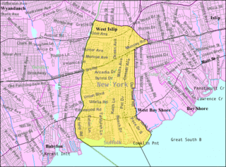
West Islip is a hamlet and CDP located in the Town of Islip in Suffolk County, New York, United States. Situated on the South Shore of Long Island, the population of the CDP was 28,335 at the time of the 2010 census.

Oak Grove, Oregon Census-designated place in Oregon, United States

Oak Grove is an unincorporated community in Clackamas County, Oregon, United States, in the Portland metropolitan area. For statistical purposes, the United States Census Bureau has defined Oak Grove as a census-designated place (CDP). The census definition of the area may not precisely correspond to local understanding of the area with the same name. The population was 16,629 at the 2010 census.

Oak Hills, Pennsylvania Census-designated place in Pennsylvania, United States

Oak Hills is a census-designated place (CDP) in Butler County, Pennsylvania, United States. The population was 2,333 at the 2010 census.

Yeagertown, Pennsylvania CDP in Pennsylvania, United States

Yeagertown is a census-designated place (CDP) in Mifflin County, Pennsylvania, United States. The population was 1,035 at the 2000 census.

Holland (CDP), New York Census-designated place in New York, United States

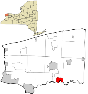
Holland is a hamlet and census-designated place (CDP) in Erie County, New York, United States. The population was 1,206 at the 2010 census. It is in the town of Holland and is part of the Buffalo–Niagara Falls Metropolitan Statistical Area.

Babylon, New York Town in New York, United States

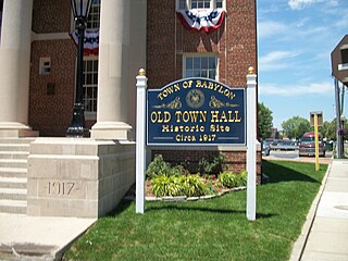
The Town of Babylon is one of ten towns in Suffolk County, New York, United States. Its population was 214,191 as of the 2010 census. Parts of Jones Beach Island, Captree Island and Fire Island are in the southernmost part of the town. It borders Nassau County to the west and the Atlantic Ocean to the south. At its westernmost point, it is about 20 miles (32 km) from New York City at the Queens border, and about 30 miles (48 km) from Manhattan. The village of Babylon is also within the town.

Gilgo, New York Hamlet and census-designated place in New York, United States

Gilgo is a hamlet and census-designated place (CDP) in the Town of Babylon in Suffolk County, New York, United States. The population was 131 at the 2010 census.

Oak Beach–Captree, New York Census-designated place in New York, United States

Oak Beach–Captree, frequently just called Oak Beach, was a census-designated place (CDP) in the town of Babylon in Suffolk County, New York, United States. The population was 286 at the 2010 census.

References

  1. "US Gazetteer files: 2010, 2000, and 1990". United States Census Bureau. 2011-02-12. Retrieved 2011-04-23.
  2. "U.S. Census website". United States Census Bureau . Retrieved 2008-01-31.