Suffolk County is the easternmost county in the U.S. state of New York, constituting the eastern two-thirds of Long Island. It is bordered to its west by Nassau County, to its east by Gardiners Bay and the open Atlantic Ocean, to its north by Long Island Sound, and to its south by the Atlantic Ocean.

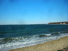
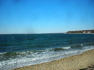
Hampton Bays is a hamlet and census-designated place (CDP) in the Town of Southampton in Suffolk County, on Long Island, in New York. It is considered as part of the region of Long Island known as The Hamptons. The population was 13,603 at the 2010 census.

Shinnecock Reservation is a Native American reservation for members of the Shinnecock Indian Nation in the town of Southampton in Suffolk County, New York, United States. It is the most easterly of the two Native American reservations in Suffolk County; the other being Poospatuck Reservation in the town of Brookhaven. It lies on the east side of Shinnecock Bay on southeastern Long Island, near Tuckahoe, Shinnecock Hills, and the village of Southampton. The population was 819 as of the 2020 census. Roughly that many tribal members additionally live off the reservation.
Riverhead is a census-designated place (CDP) roughly corresponding to the hamlet by the same name located in the Town of Riverhead in Suffolk County, on Long Island, in New York, United States. The CDP's population was 13,299 at the 2010 census.

Riverhead is a town in Suffolk County, New York, United States, on the north shore of Long Island. Since 1727, Riverhead has been the county seat of Suffolk County, though most county offices are in Hauppauge. As of the 2020 census, the population was 35,902. The town rests on the mouth of the Peconic River, from which it derives its name. The smaller hamlet of Riverhead lies within it, and is the town's principal economic center. The town is 166 miles (267 km) southwest of Boston via the Orient Point-New London Ferry, and is 76 miles (123 km) northeast of New York City.

Southampton, officially the Town of Southampton, is a town in southeastern Suffolk County, New York, partly on the South Fork of Long Island. As of the 2020 U.S. census, the town had a population of 69,036. Southampton is included in the stretch of shoreline prominently known as the Hamptons.

The Town of Southold is one of ten towns in Suffolk County, New York, United States. It is located in the northeastern tip of the county, on the North Fork of Long Island. The population was 23,732 at the 2020 census. The town contains a hamlet, also named Southold, which was settled in 1640.

Brookhaven is a large suburban town in Suffolk County, Long Island, New York. With a population of 488,497 as of 2022, it is the second most populous town in the United States and in New York and the third most populous community in the state.
The Peconic Bay is the parent name for two bays between the North Fork and South Fork of Long Island in Suffolk County, New York, United States. It is separated from Gardiners Bay by Shelter Island.

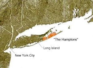
Peconic County is a proposed new county on Long Island in the U.S. state of New York that would secede the five easternmost towns of Suffolk County: East Hampton, Riverhead, Shelter Island, Southampton and Southold, plus the Shinnecock Indian Reservation.

The North Fork is a 30-mile- (48 km) long peninsula in the northeast part of Suffolk County, New York, U.S., roughly parallel with a longer peninsula known as the South Fork, both on the East End of Long Island. Although the peninsula begins east of Riverhead hamlet, the term North Fork can also refer collectively to the towns of Riverhead and Southold in their entirety.
The South Fork of Suffolk County, New York is a peninsula in the southeastern section of the county on the South Shore of Long Island. The South Fork includes most of the Hamptons. The shorter, more northerly peninsula is known as the North Fork.

The Montaukett ("Metoac"), more commonly known as Montauk are an Algonquian-speaking Native American people from the eastern and central sections of Long Island, New York.

New York's 1st congressional district is a congressional district for the United States House of Representatives in eastern Long Island. It includes the eastern two-thirds of Suffolk County, including the northern portion of Brookhaven, as well as the entirety of the towns of Huntington, Smithtown, Riverhead, Southold, Southampton, East Hampton, and Shelter Island. The district encompasses extremely wealthy enclaves such as the Hamptons, middle class suburban towns such as Selden, Centereach, and Lake Grove, working-class towns such as Riverhead and rural farming communities such as Mattituck and Jamesport on the North Fork. The district currently is represented by Republican Nick LaLota.
The Outer Barrier, also known as the Long Island and New York City barrier islands, refers to the string of barrier islands that divide the lagoons south of Long Island, New York from the Atlantic Ocean. These islands include Long Beach Barrier Island, Barnum Island, Jones Beach Island, Fire Island and Westhampton Island. The outer barrier extends 75 miles (121 km) along the South Shore of Long Island, from the Rockaway Peninsula in New York City to the east end of Shinnecock Bay in Suffolk County.
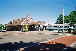
Canoe Place was a station stop along the Montauk Branch of the Long Island Rail Road and first opened as a low cinder platform on the south east side of Shinnecock Canal in 1935. The station was in service for "Fisherman's Special" trains and was closed in 1953. "Fisherman's Special" trains operated from Penn Station to Montauk and provided an intermediate stop at Canoe Place for boats waiting to take anglers out on Peconic Bay. The station was located between Hampton Bays and Suffolk Downs Stations. The hamlet where it was located is now part of Hampton Bays, New York.