Scio is a town in Allegany County, New York, United States. The population was 1,625 at the 2020 census. The town is in the southern half of the county and north of the village of Wellsville.
Lakeville is a hamlet and census-designated place (CDP) in the town of Livonia, Livingston County, New York, United States. Its population was 756 as of the 2010 census.
East Avon is a hamlet and census-designated place (CDP) in the town of Avon, Livingston County, New York, United States. The population was 608 at the 2010 census.
Rushford is a census-designated place comprising the central settlement in the town of Rushford, Allegany County, New York, United States. As of the 2010 census, it had a population of 363, out of a total population of 1,150 in the town.

Chazy is a hamlet and census-designated place (CDP) in the town of Chazy, Clinton County, New York, United States. The population was 565 at the 2010 census, out of a total town population of 4,284.
Machias is a hamlet and census-designated place (CDP) in the northeast part of the town of Machias, in Cattaraugus County, New York, United States. As of the 2010 census, it had a population of 471. Prior to the 2010 census, the area was delineated as part of the Lime Lake-Machias CDP.
Dalton is a hamlet and census-designated place (CDP) in the towns of Nunda and Portage in Livingston County, New York, United States. The population was 362 at the 2010 census.
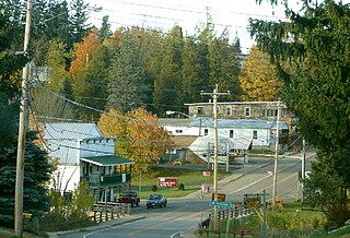
West Scio is an unincorporated community and census-designated place (CDP) in Linn County, Oregon, United States. It lies at the intersection of Jefferson–Scio Road and West Scio Road about 2 miles (3 km) west of Scio. As of the 2010 census, the population was 120.
Westport is a hamlet and census-designated place (CDP) in the town of Westport in Essex County, New York, United States. The population of the CDP was 518 at the 2010 census, or 39.4% of the total population of the town of Westport.
Willsboro is a hamlet and census-designated place (CDP) in the town of Willsboro in Essex County, New York, United States. The population of the CDP was 753 at the 2010 census, out of a total town population of 2,025.
Wilmington is a hamlet and census-designated place (CDP) in the town of Wilmington in Essex County, New York, United States. The population of the CDP was 937 at the 2010 census, out of a total town population of 1,253.
Fort Covington is a census-designated place (CDP) within the town of Fort Covington, Franklin County, New York, United States. It consists of the hamlet of Fort Covington, as well as a large amount of rural land surrounding the hamlet, such that the CDP occupies about one half of the area within the town limits. The population of the CDP was 1,308 at the 2010 census, out of a total town population of 1,676.
St. Regis Falls is a census-designated place (CDP) in Waverly, Franklin County, New York, United States. The population of the CDP was 464 at the 2010 census.
Prattsville is a hamlet and census-designated place (CDP) in the town of Prattsville, Greene County, New York, United States. The population of the CDP was 355 at the 2010 census, out of a total population of 700 in the town.
Henderson is a hamlet and census-designated place (CDP) in the town of Henderson, Jefferson County, New York, United States. The population of the CDP was 224 at the 2010 census, out of 1,360 in the entire town of Henderson.
Conesus is a hamlet in the town of Conesus, Livingston County, New York, United States. The population of the CDP was 308 at the 2010 census, out of 2,473 in the entire town of Conesus. In 2010 the CDP was listed as "Conesus Hamlet".
Greigsville is a hamlet and census-designated place (CDP) in the town of York, Livingston County, New York, United States. Its population was 209 as of the 2010 census. The community is located at the intersection of New York State Route 36 and New York State Route 63.
Groveland Station is a census-designated place (CDP) in Livingston County, New York, United States. The CDP consists of the hamlet of Groveland and nearby residential areas. The CDP population was 281 as of the 2010 census. New York State Route 63 passes through the community.
Springwater is a hamlet and census-designated place in the town of Springwater, Livingston County, New York, United States. Its population was 549 as of the 2010 census. New York State Routes 15 and 15A intersect in the community.
Scottsburg is a hamlet and census-designated place (CDP) in Livingston County, New York, United States. Its population was 117 as of the 2010 census. New York State Route 256 passes through the community.

