Friendship (CDP), New York

Last updated
Friendship, New York
USA New York location map.svg
Red pog.svg
Friendship
Location within the state of New York
Coordinates: 42°12′27″N78°8′23″W / 42.20750°N 78.13972°W / 42.20750; -78.13972 Coordinates: 42°12′27″N78°8′23″W / 42.20750°N 78.13972°W / 42.20750; -78.13972
Country United States
State New York
County Allegany
Town Friendship
Area
[1]
  Total2.89 sq mi (7.48 km2)
  Land2.89 sq mi (7.48 km2)
  Water0.00 sq mi (0.00 km2)
Elevation
1,506 ft (459 m)
Population
 (2020)
  Total1,085
  Density375.56/sq mi (145.02/km2)
Time zone UTC-5 (Eastern (EST))
  Summer (DST) UTC-4 (EDT)
ZIP code
14739
Area code 585
FIPS code 36-27694
GNIS feature ID0950738

Friendship is a hamlet (and census-designated place) in Allegany County, New York, United States. The population was 1,218 at the 2010 census. [2] The community is the principal settlement in the town of Friendship.

Contents

Geography

Friendship hamlet is in the center of the town and is next to the Southern Tier Expressway (Interstate 86 and New York State Route 17) and Van Campen Creek. The community is served by expressway exit 29, with State Route 275. County Routes 17, 20, 31, and State Route 275 converge in the hamlet. It is located on the mainline of the Western New York and Pennsylvania Railroad.

According to the United States Census Bureau, the CDP has a total area of 2.9 square miles (7.5 km2), all land. [2]

History

Although formerly a village, Friendship dissolved its municipal corporation in 1977. [3]

Demographics

Historical population
CensusPop.
2020 1,085
U.S. Decennial Census [4]

As of the census [5] of 2000, there were 1,176 people, 464 households, and 308 families residing in the CDP. The population density was 427.4 per square mile (165.1/km2). There were 535 housing units at an average density of 194.4/sq mi (75.1/km2). The racial makeup of the CDP was 94.98% White, 2.89% Black or African American, 0.17% Native American, 0.09% Asian, 0.85% from other races, and 1.02% from two or more races. Hispanic or Latino of any race were 0.85% of the population.

There were 464 households, out of which 28.9% had children under the age of 18 living with them, 50.2% were married couples living together, 12.5% had a female householder with no husband present, and 33.6% were non-families. 27.8% of all households were made up of individuals, and 13.1% had someone living alone who was 65 years of age or older. The average household size was 2.53 and the average family size was 3.09.

In the CDP, the population was spread out, with 27.5% under the age of 18, 9.0% from 18 to 24, 27.3% from 25 to 44, 20.7% from 45 to 64, and 15.5% who were 65 years of age or older. The median age was 35 years. For every 100 females, there were 95.7 males. For every 100 females age 18 and over, there were 90.0 males.

The median income for a household in the CDP was $25,524, and the median income for a family was $31,442. Males had a median income of $26,196 versus $14,554 for females. The per capita income for the CDP was $11,182. About 20.8% of families and 25.7% of the population were below the poverty line, including 33.3% of those under age 18 and 7.9% of those age 65 or over.

Related Research Articles

<span class="mw-page-title-main">Amity, New York</span> Town in New York, United States

Amity is a town in Allegany County, New York, United States. The population was 2,185 at the 2020 census. The name of the town means "friendship."

St. Bonaventure is a hamlet and census-designated place (CDP) in the town of Allegany in Cattaraugus County, New York, United States. The population was 1,963 at the 2020 census.

<span class="mw-page-title-main">North Harmony, New York</span> Town in New York, United States

North Harmony is a town in Chautauqua County, New York, United States. The population was 2,182 at the 2020 census. The town is on the west side of Chautauqua Lake. The shore of the lake is the location of many summer resort communities.

<span class="mw-page-title-main">Morrisonville, New York</span> Census-designated place in New York, United States

Morrisonville is a hamlet and census-designated place in Clinton County, New York, United States. The population was 1,545 at the 2010 census.

<span class="mw-page-title-main">Hillside Lake, New York</span> Census-designated place in New York, United States

Hillside Lake is a hamlet and census-designated place (CDP) in Dutchess County, New York, United States. The population was 1,084 at the 2010 census. It is part of the Poughkeepsie–Newburgh–Middletown, NY Metropolitan Statistical Area as well as the larger New York–Newark–Bridgeport, NY-NJ-CT-PA Combined Statistical Area.

<span class="mw-page-title-main">Red Oaks Mill, New York</span> Census-designated place in New York, United States

Red Oaks Mill is a hamlet and census-designated place (CDP) in Dutchess County, in the U.S. state of New York. It lies within the limits of the towns of Poughkeepsie and LaGrange. The population was 3,613 at the 2010 census.

La Fargeville is a hamlet and census-designated place (CDP) in the town of Orleans in Jefferson County, New York, United States. The population was 608 at the 2010 census. The hamlet is named after John Frederick La Farge, one of the early proprietors of the town. La Fargeville was once a village, but dissolved its municipal corporation in 1922.

<span class="mw-page-title-main">Seneca Knolls, New York</span> Census-designated place in New York, United States

Seneca Knolls is a hamlet in Onondaga County, New York, United States. The population was 2,011 at the 2010 census.

<span class="mw-page-title-main">Vails Gate, New York</span> CDP in New York, United States

Vails Gate is a hamlet in Orange County, New York, United States. The population was 3,369 at the 2010 census. It is part of the Poughkeepsie–Newburgh–Middletown, NY Metropolitan Statistical Area as well as the larger New York–Newark–Bridgeport, NY-NJ-CT-PA Combined Statistical Area.

<span class="mw-page-title-main">Holbrook, New York</span> Hamlet and census-designated place in New York, United States

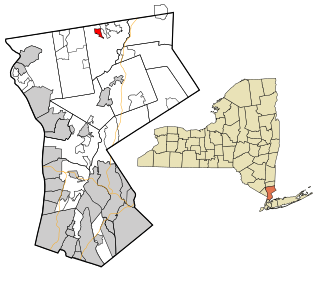
Holbrook is a hamlet and census-designated place (CDP) in Suffolk County, New York, United States. The population was 27,195 at the 2010 census. The community borders the eastern side of Long Island MacArthur Airport.

<span class="mw-page-title-main">Islip Terrace, New York</span> Hamlet and census-designated place in New York, United States

Islip Terrace is a hamlet and census-designated place (CDP) in the Town of Islip in Suffolk County, New York, United States. The population was 5,389 at the 2010 census.

<span class="mw-page-title-main">Fairview, Westchester County, New York</span> CDP in New York, United States

Fairview is a hamlet and a census-designated place (CDP) located in the town of Greenburgh, Westchester County, New York, United States. The population was 3,099 at the 2010 census. As of 2000, Fairview had the fourth-highest percentage of African-Americans in New York.

<span class="mw-page-title-main">Shenorock, New York</span> CDP in New York, United States

Shenorock is a hamlet and census-designated place (CDP) located in the town of Somers in Westchester County, New York, United States. The population was 1,898 at the 2010 census.

Friendship is a town in Allegany County, New York, United States. The population was 2,004 at the 2010 census. The town's name was adopted to mark the resolution of earlier conflicts.

Big Flats is an unincorporated community and census-designated place (CDP) within the town of Big Flats in Chemung County, New York, United States. The population of the CDP was 5,277 at the 2010 census, out of a total population in the town of 7,595.

<span class="mw-page-title-main">Amenia (CDP), New York</span> Hamlet in the state of New York, United States

Amenia is a hamlet and census-designated place (CDP) in Dutchess County, New York, United States. The population was 955 at the 2010 census. It is part of the Poughkeepsie–Newburgh–Middletown, NY Metropolitan Statistical Area as well as the larger New York–Newark–Bridgeport, NY-NJ-CT-PA Combined Statistical Area.

<span class="mw-page-title-main">Eden (CDP), New York</span> Census-designated place in New York, United States

Eden is a hamlet and census-designated place (CDP) in Erie County, New York, United States. The population was 3,516 at the 2010 census. It is part of the Buffalo–Niagara Falls Metropolitan Statistical Area.

Cairo is a hamlet and census-designated place (CDP) in the town of Cairo in Greene County, New York, United States. The population of the CDP was 1,402 at the 2010 census, out of 6,610 people in the entire town.

<span class="mw-page-title-main">Glastonbury Center, Connecticut</span> Census-designated place in Connecticut, United States

Glastonbury Center is a census-designated place (CDP) that constitutes the densely populated center of the town of Glastonbury in Hartford County, Connecticut, United States. The population was 7,387 at the 2010 census, out of a total town population of 34,427.

<span class="mw-page-title-main">Jefferson Valley, New York</span> Census-designated place in New York, United States

Jefferson Valley-Yorktown, commonly known as Jefferson Valley, is a census-designated place (CDP) located in the town of Yorktown in Westchester County, New York, United States. The population was 14,142 at the 2010 census. It is a hot spot for local shoppers, due to its Jefferson Valley Mall.

References

  1. "ArcGIS REST Services Directory". United States Census Bureau. Retrieved September 20, 2022.
  2. 1 2 "Geographic Identifiers: 2010 Demographic Profile Data (G001): Friendship CDP, New York". U.S. Census Bureau, American Factfinder. Archived from the original on February 12, 2020. Retrieved October 27, 2014.
  3. "Local Government Handbook - Table 13" (PDF) (5th ed.). New York State Department of State. 2008. p. 77. Archived from the original (PDF) on 2009-03-26. Retrieved 2009-06-06.
  4. "Census of Population and Housing". Census.gov. Retrieved June 4, 2016.
  5. "U.S. Census website". United States Census Bureau . Retrieved 2008-01-31.