Rushford, New York

Last updated

Rushford, New York
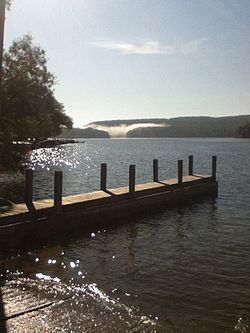
RushfordLake.jpg
Rushford Lake
USA New York location map.svg
Red pog.svg
Rushford
Location within the state of New York
Coordinates: 42°23′N78°14′W / 42.383°N 78.233°W / 42.383; -78.233
Country United States
State New York
County Allegany
Government
  Type Town Council
   Town Supervisor Peter Wade (R)
   Town Council
Members' List
Area
[1]
  Total36.08 sq mi (93.46 km2)
  Land35.29 sq mi (91.41 km2)
  Water0.79 sq mi (2.05 km2)
Elevation
1,496 ft (456 m)
Population
 (2020) [2]
  Total1,085 Decrease2.svg
  Estimate 
(2021) [2]
1,077
  Density31.90/sq mi (12.32/km2)
Time zone UTC-5 (Eastern (EST))
  Summer (DST) UTC-4 (EDT)
ZIP code
14777
Area code 585
FIPS code 36-003-64166
GNIS feature ID0979441
Website www.rushfordny.org

Rushford is a town in Allegany County, New York, United States. The population was 1,085 at the 2020 census. [2] Rushford is in the northwest part of Allegany County and is northeast of Olean.

Contents

History

The first settlers, Enos Gary and two of his children, arrived in 1808. The town of Rushford was formed in 1816 from part of the town of Caneadea. Part of Rushford was taken to form the newer town of New Hudson in 1825.

When Rushford Lake was formed by a dam on Caneadea Creek in 1927, the communities of East Rushford and Kelloggville were flooded by the rising water.

Notable people

Geography

According to the United States Census Bureau, the town has a total area of 36.1 square miles (93.5 km2), of which 35.3 square miles (91.4 km2) is land and 0.77 square miles (2.0 km2), or 2.19%, is water. [4] The town center, Rushford, is a census-designated place.

The western town line is the border of Cattaraugus County (town of Farmersville).

New York State Route 243 crosses the town (east-west).

Demographics

Historical population
CensusPop.Note
1820 609
1830 1,11583.1%
1840 1,51235.6%
1850 1,81620.1%
1860 1,8391.3%
1870 1,636−11.0%
1880 1,453−11.2%
1890 1,355−6.7%
1900 1,300−4.1%
1910 1,260−3.1%
1920 1,118−11.3%
1930 936−16.3%
1940 9673.3%
1950 935−3.3%
1960 9956.4%
1970 1,0212.6%
1980 1,12510.2%
1990 1,1764.5%
2000 1,2597.1%
2010 1,150−8.7%
2020 1,085−5.7%
2021 (est.)1,077 [2] −0.7%
U.S. Decennial Census [5]

As of the census [6] of 2000, there were 1,259 people, 479 households, and 346 families residing in the town. The population density was 35.6 inhabitants per square mile (13.7/km2). There were 1,394 housing units at an average density of 39.4 per square mile (15.2/km2). The racial makeup of the town was 98.97% White, 0.08% Native American, 0.08% Asian, 0.16% from other races, and 0.71% from two or more races. Hispanic or Latino of any race were 0.87% of the population.

There were 479 households, out of which 32.8% had children under the age of 18 living with them, 59.9% were married couples living together, 7.9% had a female householder with no husband present, and 27.6% were non-families. 21.9% of all households were made up of individuals, and 11.1% had someone living alone who was 65 years of age or older. The average household size was 2.63 and the average family size was 3.09.

In the town, the population was spread out, with 27.3% under the age of 18, 7.0% from 18 to 24, 24.3% from 25 to 44, 24.0% from 45 to 64, and 17.4% who were 65 years of age or older. The median age was 40 years. For every 100 females, there were 100.2 males. For every 100 females age 18 and over, there were 97.2 males.

The median income for a household in the town was $27,557, and the median income for a family was $30,938. Males had a median income of $26,800 versus $20,855 for females. The per capita income for the town was $13,156. About 13.4% of families and 16.1% of the population were below the poverty line, including 26.9% of those under age 18 and 6.8% of those age 65 or over.

Communities and locations in Rushford

Related Research Articles

<span class="mw-page-title-main">Allegany County, New York</span> County in New York, United States

Allegany County is a county in the U.S. state of New York. As of the 2020 census, the population was 46,456. Its county seat is Belmont. Its name derives from a Lenape word, applied by European-American settlers of Western New York State to a trail that followed the Allegheny River; they also named the county after this. The county is part of the Western New York region of the state.

<span class="mw-page-title-main">Allen, New York</span> Town in New York, United States

Allen is a town in Allegany County, New York, United States. The population was 493 at the 2020 census. The town is named after Ethan Allen.

Alma is a town in Allegany County, New York, United States. The population was 785 at the 2020 census. The source of the town name is uncertain. One source credits it to Charles Wyvell's interest in the Battle of the Alma, while another attributes it to Stephen O. Alma, first manager of the Newbold Lumber Company of Shongo.

<span class="mw-page-title-main">Amity, Allegany County, New York</span> Town in New York, United States

Amity is a town in Allegany County, New York, United States. The population was 2,185 at the 2020 census. The name of the town means "friendship."

<span class="mw-page-title-main">Belfast, New York</span> Town in New York, United States

Belfast is a town in Allegany County, New York, United States. The town is in what is called the Southern Tier of the state. Its population was 1,656 at the 2020 census. It was named in 1825 after the city of Belfast, Ireland, because it had numerous residents of Scots-Irish ancestry from that area.

Caneadea is a township in Allegany County, New York, United States. It includes the hamlets Caneadea, Houghton, and Oramel.

<span class="mw-page-title-main">Centerville, New York</span> Town in New York, United States

Centerville is a town in Allegany County, New York, United States. The population was 822 at the 2010 census. The town is in the northwest corner of Allegany County and is named after its principal settlement.

Houghton is a hamlet located in the Town of Caneadea in Allegany County, western New York, United States. The population was 1,693 at the 2010 census.

New Hudson is a town in Allegany County, New York, United States. The population was 801 at the 2020 census. The town is on the west border of the county, northeast of Olean.

Coldspring is a town in Cattaraugus County, New York, United States. As of the 2020 census it had a population of 661. It is located in the southwest part of the county, west of the city of Salamanca.

<span class="mw-page-title-main">East Otto, New York</span> Town in New York, United States

East Otto is a town in Cattaraugus County, New York, United States. The population was 977 at the 2020 census. The town, along with neighboring Otto, is named after an agent of the Holland Land Company, Jacob Otto. The town of East Otto is on the northern border of the county.

Farmersville is a town located in the eastern border of Cattaraugus County, New York, United States. The population was 1,081 at the 2020 census.

Freedom is a town in Cattaraugus County, New York, United States. The population was 2,244 at the 2021 census. The town is in the northeast corner of Cattaraugus County.

<span class="mw-page-title-main">Hinsdale, New York</span> Town in New York, United States

Hinsdale is a town in Cattaraugus County, New York, United States. The population was 2,119 at the 2020 census. The town was named after Hinsdale in New Hampshire.

Andover is a town in Allegany County, New York, United States. The population was 1,634 at the 2020 census. The town is on the eastern edge of Allegany County and contains the village of Andover.

<span class="mw-page-title-main">Cuba, New York</span> Town in New York, United States

Cuba is a town on the western border of Allegany County, New York, United States. The village of Cuba lies within its borders. The federally recognized tribe of Seneca Native Americans has a reservation on the western town line. As of the 2020 Census, the total population was 3,154.

Friendship is a town in Allegany County, New York, United States. The population was 1,960 at the 2020 census. The town's name was adopted to mark the resolution of earlier conflicts.

Allegany is a town in Cattaraugus County, New York, United States. The population was 7,493 at the 2020 census.

<span class="mw-page-title-main">Portville, New York</span> Town in New York, United States

Portville is a town in Cattaraugus County, New York, United States. The population was 3,504 at the 2020 census. The name is derived from the town's early role in shipping lumber and other items down the Allegheny River. It was formed in 1837 from the town of Olean.

Nunda is a town in Livingston County, New York, United States. The population was 3,064 at the 2010 census. Nunda welcomes visitors with signs stating "Welcome to Nunda, a Nice Place to Live." The name is derived from Nunda-wa-ono, the name given to it by a group of the Seneca people who once lived in the hills and valleys along the Genesee River and Keshequa Creek within the present-day town. In the Seneca language, "Nunda" relates to hills, and a popular translation is "Where the valley meets the hills".

References

  1. "2016 U.S. Gazetteer Files". United States Census Bureau. Retrieved July 4, 2017.
  2. 1 2 3 4 Bureau, US Census. "City and Town Population Totals: 2020—2021". Census.gov. US Census Bureau. Retrieved October 3, 2022.
  3. "First Burying Ground Cemetery". Allegany County Historical Society. Retrieved June 28, 2013.
  4. "Geographic Identifiers: 2010 Demographic Profile Data (G001): Rushford town, Allegany County, New York". U.S. Census Bureau, American Factfinder. Archived from the original on February 12, 2020. Retrieved June 28, 2013.
  5. "Census of Population and Housing". Census.gov. Retrieved June 4, 2015.
  6. "U.S. Census website". United States Census Bureau . Retrieved January 31, 2008.

42°23′N78°14′W / 42.383°N 78.233°W / 42.383; -78.233