Rapids, New York

Last updated

Rapids
CDP
Niagara County New York incorporated and unincorporated areas Rapids highlighted.svg
Location in Niagara County and the state of New York.
USA New York location map.svg
Red pog.svg
Rapids
Coordinates: 43°6′5″N78°38′28″W / 43.10139°N 78.64111°W / 43.10139; -78.64111
Country United States
State New York
County Niagara
Area
[1]
  Total3.64 sq mi (9.44 km2)
  Land3.64 sq mi (9.44 km2)
  Water0.00 sq mi (0.00 km2)
Elevation
591 ft (180 m)
Population
 (2020)
  Total1,584
  Density434.69/sq mi (167.83/km2)
Time zone UTC-5 (Eastern (EST))
  Summer (DST) UTC-4 (EDT)
FIPS code 36-60609
GNIS feature ID0962191

Rapids is a hamlet (also a census-designated place) located in the Town of Lockport in Niagara County, New York, United States. The population was 1,636 at the 2010 census. The ZIP code for Rapids is 14094.

Contents

Rapids is located on the south edge of both the town and the county so that a small part of the community is in the Town of Clarence in Erie County. The hamlet is at the junction of Tonawanda Creek Road, Rapids Road, and Goodrich Road. The community consists of a fire hall, a church, a few businesses, and many residences, primarily in Niagara County. It is part of the Buffalo Niagara Falls Metropolitan Statistical Area.

Geography

Rapids is located at 43°6′5″N78°38′28″W / 43.10139°N 78.64111°W / 43.10139; -78.64111 (43.101324, -78.641134). [2] The community is on the north side of the Tonawanda Creek, which forms the boundary between Niagara and Erie County.

According to the United States Census Bureau, the village has a total area of 3.7 square miles (9.6 km2), all land.

Tonawanda Creek flows through the community.

Demographics

Historical population
CensusPop.Note
2020 1,584
U.S. Decennial Census [3]

As of the census [4] of 2000, there were 1,356 people, 538 households, and 373 families residing in the village. The population density was 369.8 inhabitants per square mile (142.8/km2). There were 582 housing units at an average density of 158.7 per square mile (61.3/km2). The racial makeup of the CDP was 97.57% White, 1.25% African American, 0.44% Native American, 0.22% from other races, and 0.52% from two or more races. Hispanic or Latino of any race were 0.44% of the population.

There were 538 households, out of which 35.9% had children under the age of 18 living with them, 51.7% were married couples living together, 11.7% had a female householder with no husband present, and 30.5% were non-families. 24.9% of all households were made up of individuals, and 8.0% had someone living alone who was 65 years of age or older. The average household size was 2.52 and the average family size was 3.02.

In the community, the population was spread out, with 27.5% under the age of 18, 6.7% from 18 to 24, 36.4% from 25 to 44, 20.0% from 45 to 64, and 9.4% who were 65 years of age or older. The median age was 34 years. For every 100 females, there were 101.5 males. For every 100 females age 18 and over, there were 101.8 males.

The median income for a household in the CDP was $38,813, and the median income for a family was $42,067. Males had a median income of $35,859 versus $24,844 for females. The per capita income for the CDP was $19,485. About 6.5% of families and 7.0% of the population were below the poverty line, including 8.3% of those under age 18 and none of those age 65 or over.

Related Research Articles

<span class="mw-page-title-main">Silver Springs Shores, Florida</span> Census-designated place in Florida, United States

Silver Springs Shores is a census-designated place (CDP) in Marion County, Florida, United States. The population was 24,846 at the 2020 census. It is part of the Ocala Metropolitan Statistical Area.

<span class="mw-page-title-main">Billington Heights, New York</span> Census-designated place in New York, United States

Billington Heights is a hamlet and census-designated place (CDP) in the towns of Elma and Aurora in Erie County, New York, United States. The population was 1,685 at the 2010 census. It is part of the Buffalo–Niagara Falls Metropolitan Statistical Area.

<span class="mw-page-title-main">Elma Center, New York</span> Census-designated place in New York, United States

Elma Center is a hamlet and census-designated place (CDP) in the town of Elma in Erie County, New York, United States. As of the 2010 census, this community population was 2,571. It is part of the Buffalo–Niagara Falls Metropolitan Statistical Area.

<span class="mw-page-title-main">Kenmore, New York</span> Village in New York, United States

Kenmore is a village in Erie County, New York, United States. The population was 15,205 at the 2020 census. It is part of the Buffalo-Niagara Falls metropolitan area.

<span class="mw-page-title-main">Newstead, New York</span> Town in New York, United States

Newstead is the northeasternmost town in Erie County, New York, United States. The population was 8,689 at the 2020 census. The name is reportedly derived from Newstead Abbey in England.

<span class="mw-page-title-main">Alabama, New York</span> Town in New York, United States

Alabama is a town in Genesee County, New York, United States. The town is in the northwestern part of the county. New York State Routes 63 and 77 intersect in the town. The population was 1,869 at the 2010 census. The town is named after the state of Alabama.

<span class="mw-page-title-main">Gasport, New York</span> CDP & hamlet in New York, United States

Gasport is a hamlet located in the Town of Royalton in Niagara County, New York, United States. The population was 1,248 at the 2010 census. The name is derived from observed natural gas and the historic Erie Canal port at that location. It is part of the Buffalo–Niagara Falls Metropolitan Statistical Area.

<span class="mw-page-title-main">North Tonawanda, New York</span> City in New York, United States

North Tonawanda is a city in Niagara County, New York, United States. The population was 31,568 at the 2010 census. It is part of the Buffalo–Niagara Falls Metropolitan Statistical Area. The city is named after Tonawanda Creek, its south border.

<span class="mw-page-title-main">Olcott, New York</span> CDP in New York, United States

Olcott is a hamlet located in the Town of Newfane in Niagara County, New York, United States. As of the 2010 census, this community population was 1,241. Most locals refer to it as Olcott Beach. It is part of the Buffalo–Niagara Falls Metropolitan Statistical Area.

<span class="mw-page-title-main">Pendleton, New York</span> Town in New York, United States

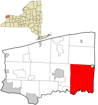
Pendleton is a town on the southern edge of Niagara County, New York, United States. It is east of the city of Niagara Falls and southwest of the city of Lockport. The population was 6,397 at the 2010 census.

<span class="mw-page-title-main">Royalton, New York</span> Town in New York, United States

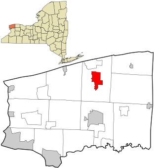
Royalton is a town in Niagara County, New York, United States. The population was 7,660 at the 2010 census.

<span class="mw-page-title-main">South Lockport, New York</span> CDP in New York, United States

South Lockport is a hamlet located in the Town of Lockport in Niagara County, New York, United States. The population was 8,234 at the 2010 census. It is part of the Buffalo–Niagara Falls Metropolitan Statistical Area.

<span class="mw-page-title-main">Wheatfield, New York</span> Town in New York, United States

Wheatfield is a town in Niagara County, New York, United States. The population was 18,117 at the 2010 census. The name stems from the agricultural use of the town lands, the growing of wheat.

<span class="mw-page-title-main">Tonawanda Reservation</span> Indian reservation in New York, United States

The Tonawanda Indian Reservation is an Indian reservation of the Tonawanda Seneca Nation located in western New York, United States. The band is a federally recognized tribe and, in the 2010 census, had 693 people living on the reservation. The reservation lies mostly in Genesee County, extending into Erie and Niagara counties. It is bordered by the Towns of Alabama, Pembroke, Newstead, and Royalton.

<span class="mw-page-title-main">Cheektowaga (CDP), New York</span> Census-designated place in New York, United States

Cheektowaga is a suburban community and census-designated place (CDP) in Erie County, New York, United States. The population was 75,178 at the 2010 census, making it the most populous census-designated place in New York. It is within the town of Cheektowaga. The CDP includes Buffalo Niagara International Airport.

<span class="mw-page-title-main">Eden (CDP), New York</span> Census-designated place in New York, United States

Eden is a hamlet and census-designated place (CDP) in Erie County, New York, United States. The population was 3,516 at the 2010 census. It is part of the Buffalo–Niagara Falls Metropolitan Statistical Area.

<span class="mw-page-title-main">Holland (CDP), New York</span> Census-designated place in New York, United States

Holland is a hamlet and census-designated place (CDP) in Erie County, New York, United States. The population was 1,206 at the 2010 census. It is in the town of Holland and is part of the Buffalo–Niagara Falls Metropolitan Statistical Area.

<span class="mw-page-title-main">Tonawanda (CDP), New York</span> Census-designated place in New York, United States

Tonawanda is a census-designated place (CDP) in Erie County, New York, United States. The CDP comprises the town of Tonawanda minus its subsidiary village of Kenmore. As of the 2010 census, the CDP population was 58,144.

<span class="mw-page-title-main">Lockport (town), New York</span> Town in New York, United States

Lockport is a town in Niagara County, New York, United States. The population was 20,529 at the 2010 census. The name is derived from the series of canal locks on the Erie Canal. The locks lift boats from the lowland of Lake Ontario past the Niagara Escarpment.

<span class="mw-page-title-main">Newfane (CDP), New York</span> CDP in New York, United States

Newfane is a census-designated place (CDP) in the town of Newfane in Niagara County, New York, United States, along State Route 78. The population was 3,822 at the 2010 census. It is part of the Buffalo–Niagara Falls Metropolitan Statistical Area.

References

  1. "ArcGIS REST Services Directory". United States Census Bureau. Retrieved September 20, 2022.
  2. "US Gazetteer files: 2010, 2000, and 1990". United States Census Bureau. February 12, 2011. Retrieved April 23, 2011.
  3. "Census of Population and Housing". Census.gov. Retrieved June 4, 2016.
  4. "U.S. Census website". United States Census Bureau . Retrieved January 31, 2008.