New York State Canal System

Last updated • 4 min readFrom Wikipedia, The Free Encyclopedia

New York State Canal System
New York State Canal Logo.png
Location Upstate New York
Country United States
Specifications
Length525 miles (845 km)
Lock length328 ft (100 m)
Lock width45 ft (14 m)
Maximum boat draft 12 ft (3.7 m)
StatusOpen
Navigation authority New York State Canal Corporation
Geography
Branch(es) Erie Canal, Champlain Canal, Oswego Canal, Cayuga–Seneca Canal
New York State Barge Canal
Lock 30, Erie Canal.jpg
Lock 30 at Macedon, 2006
Location17 counties in upstate New York
Area36.7 square miles (95 km2)
Built1905–63
ArchitectNew York State Engineer's and Surveyor's Office: Edward Bond Austin, Frank Martin Williams, David Alexander Watt, A.A. Conger, William R. Davis
NRHP reference No. 14000860 [1]
Significant dates
Added to NRHPOctober 15, 2014
Designated NHLDDecember 23, 2016

The New York State Canal System (formerly known as the New York State Barge Canal) is a successor to the Erie Canal and other canals within New York. The 525-mile (845 km) system is composed of the Erie Canal, the Oswego Canal, the Cayuga–Seneca Canal, and the Champlain Canal. [2] In 2014 the entire system was listed as a national historic district on the National Register of Historic Places, [1] and in 2016 it was designated a National Historic Landmark. [3]

Contents

The Erie Canal connects the Hudson River to Lake Erie; the Cayuga–Seneca Canal connects Seneca Lake and Cayuga Lake to the Erie Canal; the Oswego Canal connects the Erie Canal to Lake Ontario; and the Champlain Canal connects the Hudson River to Lake Champlain.

History

In 1903 New York State legislature authorized construction of the "New York State Barge Canal" as the "improvement of the Erie, the Oswego, the Champlain and the Cayuga and Seneca Canals". [4] In 1905, construction of the Barge Canal began; it was completed in 1918, at a cost of $96.7 million. [5] It opened to through traffic May 15, 1918. [6] The Barge Canal's new route took advantage of rivers (such as the Mohawk River, Oswego River, Seneca River, Genesee River and Clyde River) that the original Erie Canal builders had avoided, thus bypassing some major cities formerly on the route, such as Syracuse and Rochester. However, particularly in western New York State, the canal system uses the same (enlarged) channel as the original Erie Canal. In 1924 the Barge Canal built the Gowanus Bay Terminal in Brooklyn to handle canal cargo. [7] [8]

Lock 27 in Lyons, New York Lock27Erie.jpg
Lock 27 in Lyons, New York

Since the 1970s, the state has ceased modernizing the system due to the shift to truck transport. The canal is preserved primarily for historical and recreational purposes. Today, very few commercial vessels use the canal; it is mainly used by private pleasure boats, although it also serves as a method of controlling floods. The last regularly scheduled commercial ship operating on the canal was the Day Peckinpaugh , which ceased operation in 1994. [9]

Since 1992, the Barge Canal is no longer known by that name. Individual canals in the New York State Canal System, formerly collectively known as "the Barge Canal," are now referred to by their original names (Erie Canal, Oswego Canal, Cayuga–Seneca Canal, and Champlain Canal). Today, the system's canals are 12 feet (3.7 m) deep and 120 feet (37 m) wide, with 57 electrically operated locks, and can accommodate vessels up to 2,000 tons (1,800 metric tons). The canal system is open for navigation generally from May 1 through November 15. Payment of a fee for a permit is required to traverse the locks and lift bridges with motorized craft. [10]

In 2004, the New York State Canal Corporation reported a total of 122,034 recreational lockings on the canal, along with 8,514 tour boat lockings and 7,369 hire boat lockings, and a total of 12,182 tons of cargo valued at approximately $102 million was shipped on the canal system.

In 2012, the system's annual cargo volume reached 42,000 tons. [11]

Travel on the Canal's middle section (particularly in the Mohawk River valley) was severely hampered during destructive flooding in Upstate New York in late June and early July 2006. Flood damage to the canal system and its facilities was estimated to be at least $15 million.

In 2011, newly elected Governor Andrew Cuomo appointed Schenectady Mayor Brian Stratton as director of the Canal Corporation, which runs the Canal System.

At the end of August 2011 Tropical Storm Irene caused closure of almost the entire canal due to flooding. [12] At the beginning of September 2011, Tropical Storm Lee added more flooding to the system. Damage to several locks was severe enough to close the canal from Lock 8 (Scotia) through Lock 17 (Little Falls) from late August. [13] The canal was fully open for the start of the 2012 navigation season. [14]

Over 200,000 tons of cargo was expected for 2017, the largest shipping volume since 1993. [15]

Funding and maintenance

Sign in Waterford marking the split of the Erie and Champlain Canals Erie Canal Split Sign at Waterford New York (cropped).jpg
Sign in Waterford marking the split of the Erie and Champlain Canals

The New York State Canal Corporation is responsible for the oversight, administration and maintenance of the New York State Canal System. [2] In 2012, the Canal Corp., then a subsidiary of the New York State Thruway Authority, employed 529 people, consisting of 458 full-time employees and 78 seasonal workers. Its spending accounted for about 10 percent of the Thruway Authority's total $1.1 billion in annual spending. In 2012, the Canal Corp.'s operating budget was $55.7 million and its capital budget was $51.4 million. [16]

An August 2012 report by state Comptroller Thomas DiNapoli said the canal system "contributed to the deterioration of the Authority's financial condition over the past decade", even as canal traffic had dropped nearly one-third since the period immediately before the Thruway Authority assumed control. [17]

Effective January 1, 2017, the New York State Canal Corporation became a subsidiary of the New York Power Authority. The move was authorized in April 2016 through the state budget process. [18] Its headquarters then moved from the Thruway Authority's offices to 30 S. Pearl St., Albany, the New York Power Authority's regional offices. [19]

See also

Related Research Articles

<span class="mw-page-title-main">Erie Canal</span> Waterway in New York, U.S.

The Erie Canal is a historic canal in upstate New York that runs east–west between the Hudson River and Lake Erie. Completed in 1825, the canal was the first navigable waterway connecting the Atlantic Ocean to the Great Lakes, vastly reducing the costs of transporting people and goods across the Appalachians. In effect, the canal accelerated the settlement of the Great Lakes region, the westward expansion of the United States, and the economic ascendancy of New York State. It has been called "The Nation's First Superhighway."

<span class="mw-page-title-main">Montezuma, New York</span> Town in New York, United States

Montezuma is a town in Cayuga County, New York, United States. The population was 1,277 at the 2010 census.

<span class="mw-page-title-main">Tyre, New York</span> Town in New York, United States

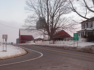
Tyre is a town in Seneca County, New York, United States. The population was 1,002 at the 2020 census. The town is named after the Lebanese city of Tyre.

<span class="mw-page-title-main">Oswego River (New York)</span> River in upstate New York in the United States

The Oswego River is a river in upstate New York in the United States. It is the second-largest river flowing into Lake Ontario. James Fenimore Cooper’s novel The Pathfinder, or The Inland Sea is set in the Oswego River valley.

<span class="mw-page-title-main">Seneca River (New York)</span> River in Upstate New York

The Seneca River flows 61.6 miles (99.1 km) through the Finger Lakes region of Upstate New York in the United States. The main tributary of the Oswego River – the second-largest river flowing into Lake Ontario – the Seneca drains 3,468 square miles (8,980 km2) in parts of fourteen New York counties. The Seneca flows generally east, and is wide and deep with a gentle gradient. Much of the river has been channelized to form part of the Erie Canal.

<span class="mw-page-title-main">Cayuga–Seneca Canal</span> Waterway in New York, U.S.

The Cayuga–Seneca Canal is a canal in New York, United States. It is now part of the New York State Canal System.

The Chemung Canal is a former canal in New York, United States. The canal connected Seneca Lake at Watkins Glen to the Chemung River at Elmira, New York. It was planned to connect the Finger Lakes region and Pennsylvania's Susquehanna River watershed with New York's Erie Canal system. The latter connected the Great Lakes with the Hudson River and ultimately the Atlantic port of New York City.

The Oswego Canal is a canal in the New York State Canal System located in New York, United States. Opened in 1828, it is 23.7 miles (38.1 km) in length, and connects the Erie Canal at Three Rivers to Lake Ontario at Oswego. The canal has a depth of 14 ft (4.3 m), with seven locks spanning the 118 ft (36 m) change in elevation.

<span class="mw-page-title-main">Champlain Canal</span> Canal in New York State, US

The Champlain Canal is a 60-mile (97 km) canal in New York that connects the Hudson River to the south end of Lake Champlain. It was simultaneously constructed with the Erie Canal for use by commercial vessels, fully opening in 1823. Today, it is mostly used by recreational boaters as part of the New York State Canal System and Lakes to Locks Passage.

The New York State Canal Corporation is a New York State public-benefit corporation responsible for the oversight, administration and maintenance of the New York State Canal System, which consists of the Erie Canal, Cayuga–Seneca Canal, Oswego Canal and Champlain Canal. It is also involved with the development and maintenance of the New York State Canalway Trail and with the general development and promotion of the Erie Canal Corridor as both a tourist attraction and a working waterway. The canal system totals 524 miles in length, and includes 57 locks and 17 lift bridges. The corporation suggests that canal boat travelers reserve 5 days to traverse the Erie Canal portion of the system.

New York state public-benefit corporations and authorities operate like quasi-private corporations, with boards of directors appointed by elected officials, overseeing both publicly operated and privately operated systems. Public-benefit nonprofit corporations share characteristics with government agencies, but they are exempt from many state and local regulations. Of particular importance, they can issue their own debt, allowing them to bypass limits on state debt contained in the New York State Constitution. This allows public authorities to make potentially risky capital and infrastructure investments without directly putting the credit of New York State or its municipalities on the line. As a result, public authorities have become widely used for financing public works, and they are now responsible for more than 90% of the state's debt.

The Commission to Explore a Route for a Canal to Lake Erie and Report, known as the Erie Canal Commission, was a body created by the New York State Legislature in 1810 to plan the Erie Canal. In 1817 a Canal Fund led by Commissioners of the Canal Fund was established to oversee the funding of construction of the canal. In 1826 a Canal Board, of which both the planning commissioners and the Canal Fund commissioners were members, was created to take control of the operational canal. The term "Canal Commission" was at times applied to any of these bodies. Afterwards the canal commissioners were minor state cabinet officers responsible for the maintenance and improvements of the state's canals.

<span class="mw-page-title-main">National Register of Historic Places listings in New York</span>

Buildings, sites, districts, and objects in New York listed on the National Register of Historic Places:

<span class="mw-page-title-main">New York State Route 370</span> State highway in central New York, US

New York State Route 370 (NY 370) is an east–west state highway in Central New York in the United States. It extends for about 35 miles (56.33 km) from an intersection with NY 104 and NY 104A south of the Wayne County village of Red Creek to a junction with U.S. Route 11 (US 11) in the Onondaga County city of Syracuse. The western and central portions of the route pass through mostly rural areas; however, the eastern section serves densely populated areas of Onondaga County, including the villages of Baldwinsville and Liverpool. NY 370 also passes through Cayuga County, where it connects to NY 34, a major north–south highway in Central New York.

<span class="mw-page-title-main">Port of Albany–Rensselaer</span> Port in United States

The Port of Albany–Rensselaer, widely known as the Port of Albany, is a port of entry in the United States with facilities on both sides of the Hudson River in Albany and Rensselaer, New York. Private and public port facilities have existed in both cities since the 17th century, with an increase in shipping after the Albany Basin and Erie Canal were built with public funds in 1825.

<span class="mw-page-title-main">Wood Creek</span> River in Central New York State

Wood Creek is a river in Central New York State that flows westward from the city of Rome, New York to Oneida Lake. Its waters flow ultimately to Lake Ontario, which is the easternmost of the five Great Lakes. Wood Creek is less than 20 miles (32 km) long, but has great historical importance. Wood Creek was a crucial, fragile link in the main 18th and early 19th century waterway connecting the Atlantic seaboard of North America and its interior beyond the Appalachian Mountains. This waterway ran upstream from the Hudson River along the Mohawk River. Near present day Rome, the Mohawk River is about one mile from Wood Creek across dry land. In the 18th century, cargo and boats were portaged between the Mohawk and Wood Creek; the crossing was called the "Oneida Carry". In 1797, the Rome Canal was completed and finally established an all-water route. The waterway then followed a downstream run along Wood Creek to the east end of Oneida Lake. After a 20 mile crossing to the west end of the lake, the waterway entered the Oswego River system. This system led either to the Lake Ontario port at Oswego, or further westward along the Seneca River.

<i>Day Peckinpaugh</i> The last self-propelled regularly scheduled commercial ship on the Erie canal.

Day Peckinpaugh is a historic canal motorship berthed at the Matton Shipyard on Peebles Island, Cohoes in Albany County, New York, United States.

<span class="mw-page-title-main">New York State Canalway Trail</span> Recreation trails along the NY State Canal System

The New York State Canalway Trail is a network of multi-use trails that runs parallel to current or former sections of the Erie, Oswego, Cayuga-Seneca, and Champlain canals. When completed, the system will have 524 miles (843 km) of trails following current and former sections of the canals. The longest of these is the 365 miles (587 km) long Erie Canalway Trail. The Erie and Champlain Canalway Trails are also part of the statewide Empire State Trail system.

<span class="mw-page-title-main">Mays Point, New York</span> Hamlet in New York, United States

Mays Point is a hamlet in the Town of Tyre, Seneca County, New York, United States, near the Wayne and Cayuga county lines. It is located seven miles (11 km) northeast of the hamlet of Seneca Falls, at an elevation of 381 feet (116 m). The primary intersection in the hamlet is at N.Y. Route 89 and Mays Point Road. Mays Point is situated along the Erie Canal near the junction of the Seneca and Clyde rivers within the Montezuma Marsh. The New York State Thruway passes just south of the hamlet.

References

  1. 1 2 "National Register of Historic Places listings for October 24, 2014". U.S. National Park Service. October 24, 2014. Retrieved October 26, 2014.
  2. 1 2 "About the Canal Corporation". New York State Canal Corporation. Retrieved June 25, 2015.
  3. "Weekly list of actions 2/16/2017 through 3/2/2017". National Park Service. Retrieved March 9, 2017.
  4. Whitford, Noble E. (1922). History of the Barge Canal of New York State. J. B. Lyon Company. p.  14 . Retrieved February 7, 2008.
  5. Whitford, Noble E. (1922). History of the Barge Canal of New York State. J. B. Lyon Company. p.  557 . Retrieved February 7, 2008.
  6. Associated Press, "Open Barge Canal Which Connects the Great Lakes With the Hudson River", The San Bernardino Daily Sun, San Bernardino, California, Wednesday 15 May 1918, Volume XLVIII, Number 65, page 1.
  7. Gleason, Gordon (August 1922). "The Worlds Largest Canal Terminal". Popular Mechanics. Retrieved February 20, 2015.
  8. "Cultural Resource Information System (CRIS)". New York State Office of Parks, Recreation and Historic Preservation. Archived from the original (Searchable database) on July 1, 2015. Retrieved November 1, 2015.Note: This includes JDuncan Hay and Kathleen LaFrank (April 2014). "National Register of Historic Places Registration Form: New York State Barge Canal" (PDF). Retrieved November 1, 2015. and Accompanying photographs
  9. "Day Peckinpaugh". Waterford Maritime Historical Society. Archived from the original on January 16, 2011. Retrieved February 13, 2011.
  10. "Tolls, Passes and Permits". New York State Canal Corporation. Retrieved May 1, 2013.
  11. New York State Canal Corporation, Report on Economic Benefits of Non‐Tourism Use of the NYS Canal System
  12. "NOTICE TO MARINERS". NY State Canal System. August 30, 2011. Retrieved November 15, 2011.
  13. "NOTICE TO MARINERS". NY State Canal System. September 26, 2011. Retrieved November 15, 2011.
  14. "Notice to Mariners: 2012 Navigation Season – Early Opening". New York State Canal Corporation. Retrieved January 17, 2013.
  15. McKinley, Jesse (May 28, 2017). "Afloat on the Erie Canal: Sonar Gear, Ferris Wheel Parts and Beer Tanks". New York Times. Retrieved May 29, 2017.
  16. McDermott, Meaghan M. (July 28, 2013). "Watchdog report: Workers 44% of canal's expense". Rochester Democrat & Chronicle. Archived from the original on November 14, 2014. Retrieved June 25, 2015.
  17. "Assessment of the Thruway Authority's Finances and Proposed Toll Increase" (PDF). Office of the State Comptroller. August 2012. p. 8. Retrieved June 25, 2015.
  18. Karlin, Rick (April 6, 2016). "NY Power Authority to absorb canal system". Times Union . Retrieved January 12, 2017.
  19. DeMasi, Michael (October 6, 2016). "State Canal Corp. moving headquarters to downtown Albany". Albany Business Review. Retrieved January 12, 2017.