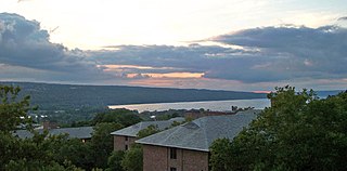
Cayuga Lake is the longest of central New York's glacial Finger Lakes, and is the second largest in surface area and second largest in volume. It is just under 39 miles (63 km) long. Its average width is 1.7 miles (2.8 km), and it is 3.5 mi wide (5.6 km) at its widest point, near Aurora. It is approximately 435 ft deep (133 m) at its deepest point, and has over 95 miles (153 km) of shoreline.

The Erie Canal is a historic canal in upstate New York that runs east–west between the Hudson River and Lake Erie. Completed in 1825, the canal was the first navigable waterway connecting the Atlantic Ocean to the Great Lakes, vastly reducing the costs of transporting people and goods across the Appalachians. The Erie Canal accelerated the settlement of the Great Lakes region, the westward expansion of the United States, and the economic ascendancy of New York state. It has been called "The Nation's First Superhighway".

Wayne County is a county in the U.S. state of New York. As of the 2020 Census, the population was 91,283. The county seat is Lyons. The name honors General Anthony Wayne, an American Revolutionary War hero and American statesman. The county is part of the Finger Lakes region of the state.

Montezuma is a town in Cayuga County, New York, United States. The population was 1,277 at the 2010 census.
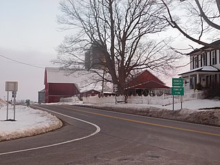
Tyre is a town in Seneca County, New York, United States. The population was 1,002 at the 2020 census. The town is named after the Lebanese city of Tyre.

Clyde is a village in Wayne County, New York, United States. The population was 2,093 at the 2010 census. It was named after the River Clyde, in Scotland, and the village sits on the Clyde River, a tributary of the Seneca River.

Galen is a town in Wayne County, New York, United States. The population was 4,290 at the 2010 census. The town is named after the classical physician Galen.

The Maumee River is a river running in the United States Midwest from northeastern Indiana into northwestern Ohio and Lake Erie. It is formed at the confluence of the St. Joseph and St. Marys rivers, where Fort Wayne, Indiana has developed, and meanders northeastwardly for 137 miles (220 km) through an agricultural region of glacial moraines before flowing into the Maumee Bay of Lake Erie. The city of Toledo is located at the mouth of the Maumee. The Maumee was designated an Ohio State Scenic River on July 18, 1974. The Maumee watershed is Ohio's breadbasket; it is two-thirds farmland, mostly corn and soybeans. It is the largest watershed of any of the rivers feeding the Great Lakes, and supplies five percent of Lake Erie's water.
Montezuma National Wildlife Refuge is a wildlife preserve operated by the United States Fish and Wildlife Service, encompassing part of the Montezuma Swamp at the north end of Cayuga Lake. The 10,004-acre (40.48 km2) preserve is composed of swamps, pools and channels and is a stopping point for migratory birds. It is the largest contiguous wetland complex in the northeastern United States and comprises a portion of the larger Montezuma Wetlands Complex, which is a partnership between the USFWS, the New York State Department of Environmental Conservation, as well as several other non-profit support organizations.

The Seneca River flows 61.6 miles (99.1 km) through the Finger Lakes region of Upstate New York in the United States. The main tributary of the Oswego River – the second-largest river flowing into Lake Ontario – the Seneca drains 3,468 square miles (8,980 km2) in parts of fourteen New York counties. The Seneca flows generally east, and is wide and deep with a gentle gradient. Much of the river has been channelized to form part of the Erie Canal.

The Cayuga–Seneca Canal is a canal in New York, United States. It is now part of the New York State Canal System. The canal connects the Erie Canal to Cayuga Lake and Seneca Lake and is approximately 20 miles (32 km) long. A multi-use trail runs beside a portion of the canal.

New York State Route 89 (NY 89) is a north–south state highway in central New York in the United States. It extends for 62.35 miles (100.34 km) from an intersection with NY 13, NY 34, and NY 96 in the Tompkins County city of Ithaca to an interchange with NY 104 in the Wayne County town of Wolcott. The route spans a total of three counties, connecting the heart of the Finger Lakes Region to a point 6 miles (10 km) south of Lake Ontario. Along the way, NY 89 intersects two regionally important highways: the conjoined routes of U.S. Route 20 (US 20) and NY 5 in Seneca Falls and NY 31 in Savannah. NY 89 runs along the western edge of Cayuga Lake from Ithaca to Seneca Falls.

Lake Erie Basin consists of Lake Erie and surrounding watersheds, which are typically named after the river, creek, or stream that provides drainage into the lake. The watersheds are located in the states of Indiana, Michigan, New York, Ohio, and Pennsylvania in the United States, and in the province of Ontario in Canada. The basin is part of the Great Lakes Basin and Saint Lawrence River Watershed, which feeds into the Atlantic Ocean. 80% of the lake's water flows in from the Detroit River, with only 9% coming from all of the remaining watersheds combined. A littoral zone serves as the interface between land and lake, being that portion of the basin where the lake is less than 15 feet (4.6 m) in depth.
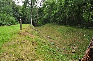
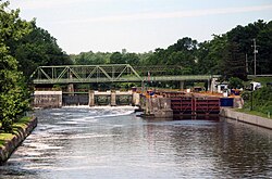
Seneca River Crossing Canals Historic District is a national historic district located at Montezuma and Tyre in Cayuga and Seneca Counties, New York. The district includes more than a mile of the Enlarged Erie Canal prism ; towpath and heelpath; a drydock; the remains of the Richmond (Montezuma) Aqueduct crossing the Seneca River; remnants of the original Erie Canal, built between 1817 and 1825 and including Lock #62 and piers of the original mule bridge from that era; and a culvert that carries a stream beneath the Enlarged Erie Canal.
Lyons is a hamlet in Wayne County, New York, United States. The population was 3,989 at the 2020 census. It is located in the southern half of the town of Lyons. The hamlet and the town are named after Lyon, France. Originally named "The Forks", Lyons was renamed by land agent George Williamson.

Ganargua Creek, also known as Mud Creek, is a main tributary which feeds the Erie Canal and Clyde River in Wayne County, New York, United States. The creek begins just east of the village of Victor in nearby Ontario County and meanders approximately 34 miles from west to east before emptying into the Erie Canal in the hamlet of Lyons. Ganargua Creek is actually split into two sections as it runs concurrent with the Erie Canal for about 3 miles near the village of Palmyra. Numerous tributaries feed Ganargua Creek along its route.

The Canandaigua Outlet is a main tributary which feeds the Erie Canal and Clyde River in Wayne County, New York, United States. It begins at Canandaigua Lake in nearby Ontario County and flows approximately 34 miles (55 km) north before emptying into the Erie Canal in the hamlet of Lyons. A number of tributaries feed the Canandaigua Outlet along its route. It is the primary outflow for Canandaigua Lake.
Marengo is a hamlet in the Town of Galen, Wayne County, New York, United States, located near the Seneca County line. It is located six miles (10 km) southwest of the Village of Clyde, at an elevation of 420 feet. The primary intersection in the hamlet is at Clyde-Marengo Road and Lyons-Marengo Road.
Lock Berlin is a hamlet in the Town of Galen, Wayne County, New York, United States. It is located four miles (6 km) west of the Village of Clyde and three miles (5 km) northeast of the hamlet of Lyons, at an elevation of 404 feet. The primary cross roads where the hamlet is located are Old Route 31, Stokes Road, Lock Berlin Road and Maple Street. N.Y. Route 31 passes just south of Lock Berlin.
Mays Point is a hamlet in the Town of Tyre, Seneca County, New York, United States, near the Wayne and Cayuga county lines. It is located seven miles (11 km) northeast of the hamlet of Seneca Falls, at an elevation of 381 feet (116 m). The primary intersection in the hamlet is at N.Y. Route 89 and Mays Point Road. Mays Point is situated along the Erie Canal near the junction of the Seneca and Clyde rivers within the Montezuma Marsh. The New York State Thruway passes just south of the hamlet.