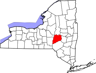
[3] Name on the Register Image Date listed [4] Location City or town Description 1 Automobile Club of Buffalo Automobile Club of Buffalo June 20, 2012 (# 12000341 10405 Main Street 42°58′47″N 78°35′56″W / 42.979857°N 78.599013°W / 42.979857; -78.599013 (Automobile Club of Buffalo ) Clarence 2 Baker Memorial Methodist Episcopal Church Baker Memorial Methodist Episcopal Church November 28, 2012 (# 12000981 345 Main St. 42°46′05″N 78°37′20″W / 42.768106°N 78.62223°W / 42.768106; -78.62223 (Baker Memorial Methodist Episcopal Church ) East Aurora 3 Bank of East Aurora Bank of East Aurora July 29, 2021 (# 100006757 649 Main St. 42°46′04″N 78°36′38″W / 42.7678°N 78.6106°W / 42.7678; -78.6106 (Bank of East Aurora ) East Aurora 4 The Baptist Church of Springville The Baptist Church of Springville December 5, 2008 (# 08001140 37 N. Buffalo St. 42°30′35″N 78°40′02″W / 42.509761°N 78.667089°W / 42.509761; -78.667089 (The Baptist Church of Springville ) Springville 5 Broadway Historic District Broadway Historic District February 17, 2015 (# 15000005 5423–5658 Broadway 42°54′00″N 78°40′13″W / 42.9000608°N 78.670387°W / 42.9000608; -78.670387 (Broadway Historic District ) Lancaster Architecture from many late 19th and early 20th centuries on this stretch of street 6 Bruce-Briggs Brick Block Bruce-Briggs Brick Block November 30, 1999 (# 99001409 5481-5483-5485 Broadway 42°53′57″N 78°40′02″W / 42.899167°N 78.667222°W / 42.899167; -78.667222 (Bruce-Briggs Brick Block ) Lancaster part of the Lancaster, New York Multiple Property Submission (MPS) 7 Buffalo Harbor South Entrance Light Buffalo Harbor South Entrance Light November 16, 2007 (# 07001191 Stony Pt. end of Buffalo Harbor S breakwater 42°50′00″N 78°52′03″W / 42.833333°N 78.8675°W / 42.833333; -78.8675 (Buffalo Harbor South Entrance Light ) Lackawanna part of the Light Stations of the United States MPS 8 Buffalo, Rochester and Pittsburgh Railroad Station Buffalo, Rochester and Pittsburgh Railroad Station November 7, 1991 (# 91001669 227 W. Main St. 42°30′32″N 78°40′32″W / 42.509006°N 78.675481°W / 42.509006; -78.675481 (Buffalo, Rochester and Pittsburgh Railroad Station ) Springville 9 Buffalo, Rochester and Pittsburgh Railroad Station Buffalo, Rochester and Pittsburgh Railroad Station August 30, 2007 (# 07000871 395 S. Lincoln Ave. 42°45′31″N 78°44′51″W / 42.758611°N 78.7475°W / 42.758611; -78.7475 (Buffalo, Rochester and Pittsburgh Railroad Station ) Orchard Park 10 Chapel of Our Lady Help of Christians Chapel of Our Lady Help of Christians December 14, 1978 (# 78001851 4125 Union Rd. 42°55′34″N 78°45′14″W / 42.926111°N 78.753889°W / 42.926111; -78.753889 (Chapel of Our Lady Help of Christians ) Cheektowaga 11 Central Avenue Historic District Central Avenue Historic District November 12, 2014 (# 14000911 16-50 Central Ave., 1-5 W. Main & 40 Clark Sts. 42°54′03″N 78°40′22″W / 42.9009623°N 78.6728664°W / 42.9009623; -78.6728664 (Central Avenue Historic District ) Lancaster Historic core of village 12 Citizens National Bank Citizens National Bank April 5, 1996 (# 96000295 5 W. Main St. 42°30′32″N 78°40′04″W / 42.508889°N 78.667778°W / 42.508889; -78.667778 (Citizens National Bank ) Springville 13 Clark-Lester House Clark-Lester House November 30, 1999 (# 99001408 5454 Broadway 42°54′00″N 78°40′06″W / 42.9°N 78.668333°W / 42.9; -78.668333 (Clark-Lester House ) Lancaster part of the Lancaster, New York MPS 14 Community of True Inspiration Residence Community of True Inspiration Residence June 25, 2013 (# 13000447 919 Mill Rd. 42°50′00″N 78°45′01″W / 42.833245°N 78.750306°W / 42.833245; -78.750306 (Community of True Inspiration Residence ) West Seneca 15 Depew High School Depew High School August 23, 2016 (# 16000593 591 Terrace Blvd. 42°54′12″N 78°41′39″W / 42.9033085°N 78.694088°W / 42.9033085; -78.694088 (Depew High School ) Depew Early example of standardized school building, constructed in 1914 and expanded to present size in 1927. After school use ended in 2008, was sold and is being converted into senior housing. 16 DePew Lodge No. 823, Free and Accepted Masons DePew Lodge No. 823, Free and Accepted Masons November 30, 1999 (# 99001410 5497 Broadway 42°53′56″N 78°40′00″W / 42.898889°N 78.666667°W / 42.898889; -78.666667 (DePew Lodge No. 823, Free and Accepted Masons ) Lancaster part of the Lancaster, New York MPS 17 East Hill Historic District East Hill Historic District August 5, 2015 (# 15000512 98-367 E. Main St 42°30′30″N 78°39′30″W / 42.5084613°N 78.6583569°W / 42.5084613; -78.6583569 (East Hill Historic District ) Springville Original residential district in village 18 East Main-Mechanic Streets Historic District East Main-Mechanic Streets Historic District January 24, 2002 (# 01001506 Approximately at the junction of East Main and Mechanic Sts. 42°30′30″N 78°39′59″W / 42.508333°N 78.666389°W / 42.508333; -78.666389 (East Main-Mechanic Streets Historic District ) Springville 19 Eaton Site Upload image April 3, 1979 (# 79001581 Address Restricted West Seneca 20 Eberhardt Mansion Eberhardt Mansion September 8, 1983 (# 83001671 2746 Delaware Ave. 42°57′32″N 78°52′12″W / 42.958889°N 78.87°W / 42.958889; -78.87 (Eberhardt Mansion ) Kenmore 21 Entranceway at Main Street at Darwin Drive Entranceway at Main Street at Darwin Drive July 23, 2009 (# 09000554 Main St. at Darwin Dr. 42°57′42″N 78°46′42″W / 42.961661°N 78.778344°W / 42.961661; -78.778344 (Entranceway at Main Street at Darwin Drive ) Amherst part of the Suburban Development of Buffalo, New York MPS 22 Entranceway at Main Street at High Park Boulevard Entranceway at Main Street at High Park Boulevard July 23, 2009 (# 09000555 Main St. at High Park Blvd. 42°57′52″N 78°48′01″W / 42.964486°N 78.800369°W / 42.964486; -78.800369 (Entranceway at Main Street at High Park Boulevard ) Amherst part of the Suburban Development of Buffalo, New York MPS 23 Entranceway at Main Street at Lafayette Boulevard Entranceway at Main Street at Lafayette Boulevard July 23, 2009 (# 09000556 Main St. at Lafayette Blvd. 42°57′37″N 78°45′39″W / 42.960192°N 78.760939°W / 42.960192; -78.760939 (Entranceway at Main Street at Lafayette Boulevard ) Amherst part of the Suburban Development of Buffalo, New York MPS 24 Entranceway at Main Street at LeBrun Road Entranceway at Main Street at LeBrun Road July 23, 2009 (# 09000557 Main St. at LeBrun Rd. 42°57′52″N 78°47′52″W / 42.964325°N 78.797653°W / 42.964325; -78.797653 (Entranceway at Main Street at LeBrun Road ) Amherst part of the Suburban Development of Buffalo, New York MPS 25 Entranceway at Main Street at Roycroft Boulevard Entranceway at Main Street at Roycroft Boulevard December 7, 2005 (# 05001378 Main St., junction with Roycroft Blvd. 42°57′44″N 78°46′48″W / 42.962208°N 78.779986°W / 42.962208; -78.779986 (Entranceway at Main Street at Roycroft Boulevard ) Amherst part of the Suburban Development of Buffalo, New York MPS 26 Entranceway at Main Street at Westfield Road and Ivyhurst Road Entranceway at Main Street at Westfield Road and Ivyhurst Road July 23, 2009 (# 09000558 Main St. at Westfield Rd. and Ivyhurst Rd. 42°57′51″N 78°48′06″W / 42.964214°N 78.801731°W / 42.964214; -78.801731 (Entranceway at Main Street at Westfield Road and Ivyhurst Road ) Amherst part of the Suburban Development of Buffalo, New York MPS 27 Entranceways at Main Street at Lamarck Drive and Smallwood Drive Entranceways at Main Street at Lamarck Drive and Smallwood Drive December 7, 2005 (# 05001379 Main St. at Lamarck Dr. and Smallwood Dr. 42°57′45″N 78°46′27″W / 42.9625°N 78.774167°W / 42.9625; -78.774167 (Entranceways at Main Street at Lamarck Drive and Smallwood Drive ) Amherst part of the Suburban Development of Buffalo, New York MPS 28 J. Eshelman and Company Store J. Eshelman and Company Store May 6, 1982 (# 82003356 6000 Goodrich Rd. 43°00′38″N 78°38′15″W / 43.010556°N 78.6375°W / 43.010556; -78.6375 (J. Eshelman and Company Store ) Clarence Center 29 Fiddlers Green Historic District Fiddlers Green Historic District September 14, 2018 (# 100002922 65-85 Franklin & 23-37 N Buffalo Sts. 42°30′32″N 78°40′17″W / 42.5088°N 78.6715°W / 42.5088; -78.6715 (Fiddlers Green Historic District ) Springville Core of present-day village, where buildings date to earliest settlement in 1818 30 Millard Fillmore House Millard Fillmore House May 30, 1974 (# 74001235 24 Shearer Ave. 42°46′06″N 78°37′21″W / 42.768333°N 78.6225°W / 42.768333; -78.6225 (Millard Fillmore House ) East Aurora 31 First Church of Evans Complex First Church of Evans Complex April 12, 2006 (# 06000257 7431 Erie Rd. 42°41′00″N 79°00′48″W / 42.683333°N 79.013333°W / 42.683333; -79.013333 (First Church of Evans Complex ) Derby 32 Gamel Hexadecagon Barn Gamel Hexadecagon Barn September 29, 1984 (# 84002386 Shirley Rd. 42°34′39″N 78°55′39″W / 42.5775°N 78.9275°W / 42.5775; -78.9275 (Gamel Hexadecagon Barn ) North Collins part of the Central Plan Dairy Barns of New York Thematic Resource (TR) 33 Garrison Cemetery Garrison Cemetery October 10, 2002 (# 02001113 Aero Dr. 42°56′49″N 78°43′50″W / 42.946944°N 78.730556°W / 42.946944; -78.730556 (Garrison Cemetery ) Cheektowaga 34 Graycliff Graycliff October 1, 1998 (# 98001222 6472-6482 Lakeshore Rd. 42°42′44″N 78°58′20″W / 42.712222°N 78.972222°W / 42.712222; -78.972222 (Graycliff ) Derby Designed by Frank Lloyd Wright as the summer estate for Isabelle and Darwin Martin (1926-31,) Graycliff is also a New York State Landmark 35 Hamburg Downtown Historic District Hamburg Downtown Historic District December 4, 2012 (# 12000997 11–235 Main Street 42°42′58″N 78°50′04″W / 42.716214°N 78.834373°W / 42.716214; -78.834373 (Hamburg Downtown Historic District ) Hamburg Intact downtown core of suburban village 36 Warren Hull House Warren Hull House May 11, 1992 (# 92000456 5976 Genesee St. 42°56′44″N 78°37′23″W / 42.945556°N 78.623056°W / 42.945556; -78.623056 (Warren Hull House ) Lancaster 37 Johnson-Jolls Complex Johnson-Jolls Complex May 6, 1980 (# 80002611 S-4287 S. Buffalo St. 42°45′28″N 78°44′39″W / 42.757778°N 78.744167°W / 42.757778; -78.744167 (Johnson-Jolls Complex ) Orchard Park 38 Kibler High School Kibler High School January 15, 1999 (# 98001612 284 Main St. 43°00′42″N 78°52′53″W / 43.011667°N 78.881389°W / 43.011667; -78.881389 (Kibler High School ) Tonawanda 39 Kleis Site Kleis Site April 20, 1979 (# 79001580 Address Restricted Hamburg 40 Lancaster District School No. 6 Lancaster District School No. 6 November 18, 2008 (# 08001076 3703 Bowen Rd. 42°52′53″N 78°38′24″W / 42.881389°N 78.64°W / 42.881389; -78.64 (Lancaster District School No. 6 ) Lancaster 41 Lancaster Municipal Building Lancaster Municipal Building November 30, 1999 (# 99001420 5423 Broadway 42°54′00″N 78°40′14″W / 42.9°N 78.670556°W / 42.9; -78.670556 (Lancaster Municipal Building ) Lancaster part of the Lancaster, New York MPS 42 Liebler-Rohl Gasoline Station Liebler-Rohl Gasoline Station November 30, 1999 (# 99001411 5500 Broadway 42°53′58″N 78°39′59″W / 42.8994°N 78.6664°W / 42.8994; -78.6664 (Liebler-Rohl Gasoline Station ) Lancaster part of the Lancaster, New York MPS 43 Lustron House Westchester Deluxe Model M02 #01310 Upload image August 16, 2023 (# 100008880 3381 North Boston Rd. 42°40′44″N 78°51′47″W / 42.6789°N 78.8631°W / 42.6789; -78.8631 (Lustron House Westchester Deluxe Model M02 #01310 ) Eden 44 Miller-Mackey House Miller-Mackey House November 30, 1999 (# 99001422 5440 Broadway 42°54′01″N 78°40′09″W / 42.9003°N 78.6692°W / 42.9003; -78.6692 (Miller-Mackey House ) Lancaster part of the Lancaster, New York MPS 45 Newton–Hopper Village Site Upload image April 3, 2012 (# 12000176 Address Restricted Elma 46 New York State Barge Canal New York State Barge Canal October 15, 2014 (# 14000860 Linear across county 43°01′13″N 78°52′30″W / 43.0204°N 78.8750°W / 43.0204; -78.8750 (New York State Barge Canal ) Amherst, Tonawanda Successor to Erie Canal approved by state voters in early 20th century to compete with railroads. 47 Dr. John J. Nowak House Dr. John J. Nowak House November 30, 1999 (# 99001414 5539 Broadway 42°53′51″N 78°39′49″W / 42.8975°N 78.6636°W / 42.8975; -78.6636 (Dr. John J. Nowak House ) Lancaster part of the Lancaster, New York MPS 48 Old Sardinia Town Hall Old Sardinia Town Hall December 23, 2008 (# 08001231 12070 Savage Road 42°32′58″N 78°30′29″W / 42.5495°N 78.5081°W / 42.5495; -78.5081 (Old Sardinia Town Hall ) Sardinia 49 Our Lady of Victory National Shrine and Basilica Historic District Our Lady of Victory National Shrine and Basilica Historic District February 26, 2024 (# 100009962 777 Ridge Road and 781 Ridge Road 42°49′33″N 78°49′25″W / 42.8258°N 78.8236°W / 42.8258; -78.8236 (Our Lady of Victory National Shrine and Basilica Historic District ) Lackawanna 50 Our Mother of Good Counsel Roman Catholic Church Complex Our Mother of Good Counsel Roman Catholic Church Complex December 21, 2020 (# 100005914 3688 South Park Ave. and 15 Oakwood Ave. 42°47′55″N 78°49′25″W / 42.7985°N 78.8237°W / 42.7985; -78.8237 (Our Mother of Good Counsel Roman Catholic Church Complex ) Blasdell 51 Pioneer Cemetery Pioneer Cemetery January 4, 2012 (# 11000997 West side of N. Main St. between Gold St. & Beach Rd. 42°39′11″N 79°02′07″W / 42.6531°N 79.0354°W / 42.6531; -79.0354 (Pioneer Cemetery ) Evans Center 52 Former Reformed Mennonite Church Former Reformed Mennonite Church July 3, 2003 (# 03000596 5178 Main St. 42°57′39″N 78°45′35″W / 42.9608°N 78.7597°W / 42.9608; -78.7597 (Former Reformed Mennonite Church ) Amherst 53 Rich-Twinn Octagon House Rich-Twinn Octagon House February 10, 1995 (# 95000050 145 Main St. 43°01′19″N 78°29′44″W / 43.0219°N 78.4956°W / 43.0219; -78.4956 (Rich-Twinn Octagon House ) Akron 54 John Richardson House John Richardson House November 30, 1999 (# 99001419 5653 Broadway 42°53′48″N 78°39′29″W / 42.8967°N 78.6581°W / 42.8967; -78.6581 (John Richardson House ) Lancaster part of the Lancaster, New York MPS 55 Rider-Hopkins Farm and Olmsted Camp Rider-Hopkins Farm and Olmsted Camp January 15, 1999 (# 98001613 12820 Benton Rd. 42°31′52″N 78°30′43″W / 42.5311°N 78.5119°W / 42.5311; -78.5119 (Rider-Hopkins Farm and Olmsted Camp ) Sardinia 56 Roycroft Campus Roycroft Campus November 8, 1974 (# 74001236 Main and W. Grove Sts. 42°46′01″N 78°37′09″W / 42.7669°N 78.6192°W / 42.7669; -78.6192 (Roycroft Campus ) East Aurora 57 St. Paul's Roman Catholic Church Complex St. Paul's Roman Catholic Church Complex July 11, 2022 (# 100007890 2930 Delaware Ave, 45 Victoria Blvd. 42°57′49″N 78°52′13″W / 42.9637°N 78.8703°W / 42.9637; -78.8703 (St. Paul's Roman Catholic Church Complex ) Kenmore 58 George and Gladys Scheidemantel House George and Gladys Scheidemantel House August 5, 1993 (# 93000778 363 Oakwood Ave. 42°45′56″N 78°37′18″W / 42.7656°N 78.6217°W / 42.7656; -78.6217 (George and Gladys Scheidemantel House ) East Aurora 59 Scobey Power Plant and Dam Scobey Power Plant and Dam September 20, 1996 (# 96000296 Junction of Scobey Hill Rd. and Cattaraugus Cr. 42°28′42″N 78°41′56″W / 42.4783°N 78.6989°W / 42.4783; -78.6989 (Scobey Power Plant and Dam ) Springville 60 John P. Sommers House John P. Sommers House January 4, 2012 (# 11000998 33 Lake Ave. 42°53′54″N 78°40′06″W / 42.8982°N 78.6684°W / 42.8982; -78.6684 (John P. Sommers House ) Lancaster part of the Lancaster, New York MPS 61 Spaulding-Sidway Boathouse Spaulding-Sidway Boathouse May 20, 1998 (# 98000552 2296 W. Oakfield Rd. 42°58′16″N 78°58′38″W / 42.9711°N 78.9772°W / 42.9711; -78.9772 (Spaulding-Sidway Boathouse ) Grand Island 62 St. Mary of the Angels Motherhouse Complex St. Mary of the Angels Motherhouse Complex October 24, 2002 (# 02001046 400 Mill St. 42°58′19″N 78°44′52″W / 42.9719°N 78.7478°W / 42.9719; -78.7478 (St. Mary of the Angels Motherhouse Complex ) Amherst 63 St. Matthias Episcopal Church Complex St. Matthias Episcopal Church Complex December 3, 2019 (# 100004735 374 Main St., 24 Maple St. 42°46′06″N 78°37′15″W / 42.7684°N 78.6207°W / 42.7684; -78.6207 (St. Matthias Episcopal Church Complex ) East Aurora 1928 English Gothc Revival church based on rural English parish churches 64 Thomas Indian School Thomas Indian School January 25, 1973 (# 73001188 NY 438 on Cattaraugus Reservation 42°32′22″N 78°59′48″W / 42.5394°N 78.9967°W / 42.5394; -78.9967 (Thomas Indian School ) Irving 65 Tonawanda (25th Separate Company) Armory Tonawanda (25th Separate Company) Armory January 28, 1994 (# 93001539 79 Delaware Ave. 43°02′39″N 78°52′22″W / 43.0442°N 78.8728°W / 43.0442; -78.8728 (Tonawanda (25th Separate Company) Armory ) Tonawanda Castellated armory building constructed in 1896; part of the Army National Guard Armories in New York State MPS 66 Tonawanda Municipal Building Tonawanda Municipal Building June 12, 2013 (# 13000370 2919 Delaware Ave. 42°57′49″N 78°52′11″W / 42.963619°N 78.8698°W / 42.963619; -78.8698 (Tonawanda Municipal Building ) Kenmore Art Deco municipal building constructed in 1930s. 67 US Post Office-Akron US Post Office-Akron November 17, 1988 (# 88002449 118 Main St. 43°01′13″N 78°29′53″W / 43.020321°N 78.497956°W / 43.020321; -78.497956 (US Post Office-Akron ) Akron part of the US Post Offices in New York State, 1858-1943, TR 68 US Post Office-Angola US Post Office-Angola November 17, 1988 (# 88002452 80 N. Main St. 42°38′23″N 79°01′42″W / 42.639722°N 79.028333°W / 42.639722; -79.028333 (US Post Office-Angola ) Angola part of the US Post Offices in New York State, 1858-1943, TR 69 US Post Office-Depew US Post Office-Depew November 17, 1988 (# 88002481 165 Warsaw St. [5] 42°54′14″N 78°41′25″W / 42.903889°N 78.690278°W / 42.903889; -78.690278 (US Post Office-Depew ) Depew part of the US Post Offices in New York State, 1858-1943, TR 70 US Post Office-Lancaster US Post Office-Lancaster May 11, 1989 (# 88002340 5406 Broadway St. [6] 42°54′01″N 78°40′17″W / 42.900278°N 78.671389°W / 42.900278; -78.671389 (US Post Office-Lancaster ) Lancaster part of the US Post Offices in New York State, 1858-1943, TR 71 US Post Office-Springville US Post Office-Springville May 11, 1989 (# 88002433 75 Franklin St. 42°30′34″N 78°39′58″W / 42.509444°N 78.666111°W / 42.509444; -78.666111 (US Post Office-Springville ) Springville part of the US Post Offices in New York State, 1858-1943, TR 72 US Post Office-Tonawanda US Post Office-Tonawanda May 11, 1989 (# 88002437 96 Seymour St. 43°01′01″N 78°52′47″W / 43.016944°N 78.879722°W / 43.016944; -78.879722 (US Post Office-Tonawanda ) Tonawanda part of the US Post Offices in New York State, 1858-1943, TR 73 Herman B. VanPeyma House Herman B. VanPeyma House November 30, 1999 (# 99001417 5565 Broadway 42°53′51″N 78°39′42″W / 42.8975°N 78.661667°W / 42.8975; -78.661667 (Herman B. VanPeyma House ) Lancaster part of the Lancaster, New York MPS 74 Villa Maria Motherhouse Complex Villa Maria Motherhouse Complex July 14, 2006 (# 06000571 600 Doat St. 42°54′37″N 78°47′55″W / 42.910278°N 78.798611°W / 42.910278; -78.798611 (Villa Maria Motherhouse Complex ) Cheektowaga 75 West End Historic District West End Historic District March 12, 2018 (# SG100002187 90-171 W Main, 17 Park & 186-244 Franklin Sts. & 24-110 N Central Ave. 42°30′32″N 78°40′17″W / 42.508784°N 78.671490°W / 42.508784; -78.671490 (West End Historic District ) Springville Intact enclave of religious buildings and houses at west side of village developed in late 19th and early 20th centuries following 1878 Springville and Sardinia Railroad completion 76 Williamsville Christian Church Williamsville Christian Church May 22, 2002 (# 02000546 5658 Main St. 42°57′48″N 78°44′33″W / 42.963333°N 78.7425°W / 42.963333; -78.7425 (Williamsville Christian Church ) Williamsville 77 Williamsville Junior and Senior High School Williamsville Junior and Senior High School May 12, 2008 (# 08000407 5950 Main St. 42°57′53″N 78°43′59″W / 42.964783°N 78.732997°W / 42.964783; -78.732997 (Williamsville Junior and Senior High School ) Williamsville 78 Williamsville Water Mill Complex Williamsville Water Mill Complex September 22, 1983 (# 83001675 56 and 60 Spring St. 42°57′48″N 78°43′56″W / 42.963333°N 78.732222°W / 42.963333; -78.732222 (Williamsville Water Mill Complex ) Williamsville 79 Wood and Brooks Company Factory Complex Upload image July 28, 2023 (# 100009162 2101 Kenmore Ave. 42°57′48″N 78°53′40″W / 42.9633°N 78.8945°W / 42.9633; -78.8945 (Wood and Brooks Company Factory Complex ) Tonawanda 80 Zuidema-Idsardi House Zuidema-Idsardi House November 30, 1999 (# 99001416 5556 Broadway 42°53′54″N 78°39′45″W / 42.898333°N 78.6625°W / 42.898333; -78.6625 (Zuidema-Idsardi House ) Lancaster part of the Lancaster, New York MPS