Entranceway at Main Street at Roycroft Boulevard

Last updated

Entranceway at Main Street at Roycroft Boulevard
20090412 Entranceway at Main Street at Roycroft Boulevard from south.JPG
Entranceway at Main Street at Roycroft Boulevard from south, April 12, 2009
USA New York location map.svg
Red pog.svg
Usa edcp location map.svg
Red pog.svg
LocationMain St., jct. with Roycroft Blvd., Amherst, New York
Coordinates 42°57′43.95″N78°46′47.95″W / 42.9622083°N 78.7799861°W / 42.9622083; -78.7799861
Built1918
ArchitectAbbot and Beymer
Architectural styleTudor Revival
MPS Suburban Development of Buffalo, New York MPS
NRHP reference No. 05001378 [1]
Added to NRHPDecember 7, 2005

Entranceway at Main Street at Roycroft Boulevard is a suburban residential subdivision entranceway built in 1918. It is on Main Street (New York State Route 5) in the hamlet of Snyder, New York, in the town of Amherst within Erie County. The entranceway is a marker that represents the American suburbanization of rural areas, suburbanization that occurred through transportation-related land development on the edges of urban areas. It consists of a variety of half-height wall formations, featuring a semicircular wall on the Roycroft Boulevard median's intersection with Main Street. [2] [3] The entranceway was added to the National Register of Historic Places on December 7, 2005. [1]

Contents

History

Williamsville developed around a mill erected in 1811, and the town of Amherst was born in 1818. At that time, Main Street was the main link from Williamsville and Amherst to Buffalo. [4] Main Street was displaced as "the unchallenged main artery of Amherst and Western New York" by the Erie Canal in 1825 and later by adjacent railroads. [4] By 1866, Buffalo Street Railway Company built a street car system that ran on Main Street from Amherst to Buffalo. [4] Daily stage coach service also began in 1866 along Main Street and continued until it was displaced by an electric trolley in 1893, the track ran 4.5 miles (7.2 km) from Main and Bailey Avenue (U.S. Route 62 in New York) to the east with stops that included Entranceways at Main Street at Lamarck Drive and Smallwood Drive. [4]

The early 20th century estate era gave way to the residential subdivision era. Suburban Buffalo's subdivisions took on an urban flavor along the area's main thoroughfares and paths of migration. Charles S. Burkhardt began Audubon Terrace on 400 acres north of Main Street in October 1919 on the Taylor and Satterfield Estates. [4]

Location

Snyder, NY's original National Register of Historic Places Entranceways at Lamarck Drive and Smallwood Drive and Roycroft Boulevard were added in to the register in 2005. Later other entranceways were added to the register. Snyder, New York National Register of Historic Places Entranceways.png
Snyder, NY's original National Register of Historic Places Entranceways at Lamarck Drive and Smallwood Drive and Roycroft Boulevard were added in to the register in 2005. Later other entranceways were added to the register.

Today, Main Street is a four-lane road running east–west through Snyder connecting Williamsville (the other side of Interstate 290, known as the Youngman Expressway) to points westward such as the neighboring hamlet of Eggertsville and downtown Buffalo. The entranceway is located proximate to large residential areas of trees and grass, 1920s-built subdivisions flanking a wide central median. [2] It is situated three blocks east of Harlem Road (New York State Route 240). Across Main Street and northeast from the Entranceway is the Eggertsville-Snyder Branch Library of the Buffalo & Erie County Public Library located at 4622 Main Street. [5] [6] Each side of the median serves one-way traffic. The entranceways sit on the two south side corners of this T-junction intersection. [2]

Architecture

20090412 Entranceway at Main Street at Roycroft Boulevard from northeast.JPG
20090412 Entranceway at Main Street at Roycroft Boulevard from northwest.JPG
Entranceway from Eggertsville-Snyder Branch Library to the northeast (top) and northwest (bottom)

Completed in 1918, the entranceway's featured element is the nearly semi-circular random ashlar stone half-walls on Roycroft Boulevard's axis of symmetry, which is at a 22 degree angle to Main Street. [2] The wall has one central and two end square posts that are approximately 4 feet (1.2 m) in height and that have poured concrete caps that are not original. [2] Each post has a metal and glass contemporary street lamp projecting from its center. Quarter points of the arc have stone pilaster ornamentation. [2] The running portion of the wall has a continuous cast in place coping cap shaped at a 45 degree angle, which forms an attached buttress three quarters the height of the posts. [2] Past repairs have included incompatible stone and mortar patches. [2] The Main Street paving and the grassy median abut the convex and concave sides, respectively. [2] According to the August 5, 2005, application, the entranceway is in a state of disrepair, lacking a visible base and having a tilt. [2] :3

On opposite sides of the Roycroft Boulevard roadways from the central feature are flanking structures with random ashlar stone posts and half-height walls. They are oriented parallel to the angular Roycroft Boulevard and have lengths proportionate to the central wall end post's distance from Main Street. [2] Both walls are L-shaped with the longer length extending along Roycroft Boulevard and having a short cornered length along Main Street. [2] These walls have capped, square stone buttress-less posts and corners marked by wall-height stone pilaster. [2] On the opposite side of each from the a concrete sidewalk parallel to Roycroft Boulevard is a free-standing stone post. [2] The west side is in fair condition, while the east side is out of vertical alignment and is in poor condition. [2] The east side has the distinction of retaining the only original cast concrete cap with a circular recess on its north end post. [2] It presumably once held an original lamp post and was once painted white. [2] Its south end post has a four-piece, white terra cotta cap resembling the other non-original end posts in the set of structures. [2]

Legacy

The entryways remain in their original location, retain original design, and setting. They continue to mark the entrance to the subdivision's entrance for vehicular and pedestrian traffic as they were originally designed to do. [2] Abbott and Beymer Land Co. purchased the land for the Aurora Park subdivision that the entranceway has marked since its 1918 construction. [2] The street and plot plan were designed by the Straley Brothers, who were civil engineers and surveyors from Buffalo. [2] County engineer, George C. Diehl, had a role in the development of this subdivision. [2] The entranceway was added to the National Register of Historic Places on December 7, 2005. [1]

See also

Related Research Articles

<span class="mw-page-title-main">Erie County, New York</span> County in New York, United States

Erie County is a county along the shore of Lake Erie in western New York State. As of the 2020 census, the population was 954,236. The county seat is Buffalo, which makes up about 28% of the county's population. Both the county and Lake Erie were named for the regional Iroquoian language-speaking Erie tribe of Native Americans, who lived in the area before 1654. They were later pushed out by the more powerful Iroquoian nations tribes.

<span class="mw-page-title-main">Amherst, New York</span> Town in New York, United States

Amherst is a town in Erie County, New York, United States. It is a suburb of Buffalo. As of 2020, the town had a total population of 129,595. This represents an increase from 122,366 as reported in the 2010 census. It is the 14th most populated City/Town in New York.

<span class="mw-page-title-main">Clarence, New York</span> Town in New York, United States

Clarence is a town and affluent suburb located in the northeastern part of Erie County, New York, United States, northeast of Buffalo. The population was 32,950 according to the 2020 census estimate. This represents an increase of 7.4% from the 2010 census figure. The Clarence census-designated place occupies the southeast part of the town and roughly corresponds to a postal district with ZIP code 14031 and 14221 in the western side which it shares with nearby Williamsville. The town is named in honor of Prince William, Duke of Clarence and St Andrews (1765–1837), the third son of King George III and later king himself, as William IV.

<span class="mw-page-title-main">Williamsville, New York</span> Village in New York, United States

Williamsville is a village in Erie County, New York, United States. The population was 5,423 at the 2020 census. The village is named after Jonas Williams, an early settler. It is part of the Buffalo-Niagara Falls metropolitan area.

<span class="mw-page-title-main">Cheektowaga, New York</span> Town in New York, United States

Cheektowaga is a town in Erie County, New York, United States. As of the 2020 census, the town has grown to a population of 89,877. The town is in the north-central part of the county, and is an inner ring suburb of Buffalo. The town is the second-largest suburb of Buffalo, after the Town of Amherst.

<span class="mw-page-title-main">University station (Buffalo Metro Rail)</span> Light rail station in Buffalo, New York, US

University is a Buffalo Metro Rail station located near the intersection of Main Street and Niagara Falls Boulevard on the University at Buffalo South Campus. It is a major transfer point between Metro Rail and many city and suburban bus routes and offers a unique "Kiss and Ride" facility on the top level, above the mezzanine. This allows drivers of automobiles a separate area to drop off passengers, so they do not add to the traffic congestion from buses at the station during rush-hour periods and a large park-and-ride facility directly to the east of the station. Since University station serves as a terminal, immediately south is a double crossover. From May 20, 1985, to November 10, 1986, due to construction issues at LaSalle station, Amherst Street station served as the northern terminus. Since November 10, 1986, university station has served as the northern terminus.

<span class="mw-page-title-main">East Amherst, New York</span> Hamlet in New York, United States

East Amherst is a suburban hamlet 16 miles (26 km) northeast of downtown Buffalo, Erie County, New York, United States. It straddles the towns of Amherst and Clarence, and comprises the majority of ZIP code 14051.

Amherst State Park is an 80-acre (0.32 km2) park in Erie County, New York, United States. The park is located northeast of Buffalo, partially in the Village of Williamsville with the balance located in the Town of Amherst. The park is managed by the Town of Amherst under an agreement with the New York State Office of Parks, Recreation and Historic Preservation.

<span class="mw-page-title-main">Williamsville South High School</span> School in Williamsville, New York, United States

Williamsville South High School is a high school located in Williamsville, New York, a suburb of Buffalo, New York. South is one of three high schools in the Williamsville Central School District, along with Williamsville North High School and Williamsville East High School.

<span class="mw-page-title-main">Snyder, New York</span> Hamlet in New York, United States

Snyder is a hamlet within the town of Amherst in Erie County, New York, that is part of the Buffalo–Niagara Falls metropolitan area. The hamlet was established in 1837. It was named for Michael Snyder, its first postmaster, who also operated a store at the corner of Harlem Road, which is also known as New York State Route 240, and Main Street, which is also known as New York State Route 5. The hamlet blossomed due to retail activity demand created along the Main Street transportation route between Buffalo and points to the east in the 19th and early 20th century.

<span class="mw-page-title-main">Buffalo & Erie County Public Library</span> Library system in western New York (USA)

The Buffalo & Erie County Public Library is located on Lafayette Square, Buffalo, New York. The current facility, designed by Kideney Architects and built in 1964, replaced the original Cyrus Eidlitz Buffalo Public Library Building dedicated in February 1887. The first Buffalo Public Library, in turn, replaced the Erie County, New York courthouse, which occupied the parcel from 1816-1876.

<span class="mw-page-title-main">Getzville, New York</span> Hamlet in New York, United States

Getzville is a hamlet in the town of Amherst in Erie County, New York, United States. Getzville's ZIP code is 14068, and its post office is located on Millersport Highway.

<span class="mw-page-title-main">Southtowns</span> Term for southern suburbs of Buffalo, NY

The Southtowns is a region of Western New York, United States, that lies within the snowbelt or ski country. It includes the southern suburbs of Buffalo, New York. This is the common name for the southern part of Erie County, New York.

<span class="mw-page-title-main">Entranceways at Main Street at Lamarck Drive and Smallwood Drive</span> United States historic place

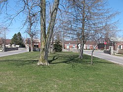
Entranceways at Main Street at Lamarck Drive and Smallwood Drive are a set of complementary residential subdivision stone entranceways built in 1926. They are located on Main Street in the hamlet of Snyder, New York within the town of Amherst, which is located in Erie County. These entranceways are markers representing the American suburbanization of rural areas through land development associated with transportation on the edges of urban developments. The Smallwood entranceway is a pair of symmetric groupings of stone gatehouses and posts flanking the two sides of the drive at Main Street. The Lamarck entranceway is a pair of Y-shaped and U-shaped stone half-walls flanking the two sides of the drive at Main Street. The entranceways were added to the National Register of Historic Places on December 7, 2005.

<span class="mw-page-title-main">Eggertsville, New York</span> Census-designated place in New York, United States

Eggertsville is a hamlet and census-designated place (CDP) within the town of Amherst in Erie County, New York, United States. The population of the CDP was 15,019 at the 2010 census.

<span class="mw-page-title-main">Entranceway at Main Street at Darwin Drive</span> United States historic place

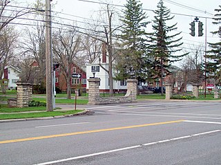
Entranceway at Main Street at Darwin Drive is a suburban residential subdivision entranceway and street furniture built about 1927 by developer Charles S. Burkhardt. It is located on Main Street in the town of Amherst within Erie County. It consists of two matching sets of stone sculptures set on either side of the drive. It also includes the painted metal street sign post.

<span class="mw-page-title-main">Entranceway at Main Street at High Park Boulevard</span> United States historic place

Entranceway at Main Street at High Park Boulevard is a suburban residential subdivision entranceway built about 1916 by developer Charles S. Burkhardt. It is located on Main Street at Eggertsville in the town of Amherst within Erie County. It consists of tall and short stone posts, corresponding quarter-height stone walls, and accent light fixtures set on either side of the streets' intersecting corners.

<span class="mw-page-title-main">Entranceway at Main Street at Lafayette Boulevard</span> United States historic place

Entranceway at Main Street at Lafayette Boulevard is a suburban residential subdivision entranceway built about 1920 by Orange & Black Corp., Developers. It is located on Main Street in the town of Amherst within Erie County. It consists of roofed stone archways, connecting half-height stone walls, and stone posts located on either corner.

<span class="mw-page-title-main">Entranceway at Main Street at LeBrun Road</span> United States historic place

Entranceway at Main Street at LeBrun Road is a suburban residential subdivision entranceway in Amherst, New York, USA. It was built about 1920 by Goode & Sickels, Realtors. It is located on Main Street at Eggertsville in the town of Amherst within Erie County. It consists of half-height brick masonry walls, brick masonry posts, and accent light fixtures located on either street corner.

<span class="mw-page-title-main">Entranceway at Main Street at Westfield Road and Ivyhurst Road</span> United States historic place

Entranceway at Main Street at Westfield Road and Ivyhurst Road is a suburban residential subdivision entranceway built about 1920 by John Sattler. It is located on Main Street in the town of Amherst within Erie County. It consists of stone posts, connecting quarter-height stone walls, and accent light fixtures located on either street corner.

References

  1. 1 2 3 "National Register Information System". National Register of Historic Places . National Park Service. March 13, 2009.
  2. 1 2 3 4 5 6 7 8 9 10 11 12 13 14 15 16 17 18 19 20 21 22 Ross, Claire L. (October 8, 2005). "NPS Form 10-900: Entranceway at Main Street at Roycroft Boulevard". National Park Service . Retrieved August 25, 2013.
  3. "Cultural Resource Information System (CRIS)". New York State Office of Parks, Recreation and Historic Preservation. Archived from the original (Searchable database) on April 4, 2019. Retrieved July 1, 2016.Note: This includes Claire L. Ross (July 2005). "National Register of Historic Places Registration Form: Entranceway at Main Street at Roycroft Boulevard" (PDF). Retrieved July 1, 2016. and Accompanying two photographs
  4. 1 2 3 4 5 "National Register of Historic Places Multiple Property Documentation Form: Multiple Resources Associated with the Suburban Development of Buffalo, New York". National Register of Historic Places. October 8, 2005. Retrieved August 28, 2013.
  5. "Eggertsville-Snyder Branch Library". JustDial.com. Retrieved August 21, 2013.
  6. "Eggertsville-Snyder Branch". Buffalo & Erie County Public Library. Archived from the original on July 10, 2013. Retrieved August 21, 2013.