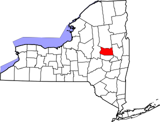
This is intended to be a complete list of properties and districts listed on the National Register of Historic Places in Herkimer County, New York. The locations of National Register properties and districts (at least for all showing latitude and longitude coordinates below) may be seen in a map by clicking on "Map of all coordinates".[1] Two districts are further designated a National Historic Landmark (NHL), and part of the county is included in the Adirondack Forest Preserve, another NHL.
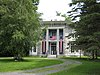
Home of George Ward, who prosecuted Chester Gillette for the murder of Grace Brown in 1906, the case which served as the model for Theodore Dreiser's An American Tragedy. Now a bed and breakfast operated by Ward's great-grandson
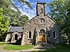
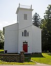
The district, declared a National Historic Landmark in 1993,[5] includes the Indian Castle Church as well as archaeological sites. Upper Castle was a fortified village. The Indian Castle Church, built in 1769, is the only colonial Indian missionary church surviving in New York State, and is the only Iroquois building surviving from its time.[6]
Little Falls, Danube, Frankfort, German Flatts, Herkimer, Ilion, Mannheim, Mohawk, Ohio, Russia, Schuyler
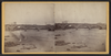
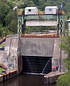
Successor to Erie Canal approved by state voters in early 20th century to compete with railroads; listing includes two of canal's reservoirs in Adirondacks.
An octagonal house and the adjoining site of the lock factory of Linus Yale Sr. and his son Linus Yale Jr., the inventor of the cylinder lock. Linus Yale Sr. built the house in 1849 as a gift for his daughter.
List of the National Register of Historic Places listings in Fulton County, New York
List of the National Register of Historic Places listings in Genesee County, New York
List of the National Register of Historic Places listings in Hamilton County, New York
List of the National Register of Historic Places listings in Lewis County, New York
List of the National Register of Historic Places listings in Livingston County, New York
List of the National Register of Historic Places listings in Montgomery County, New York
This is a list of the National Register of Historic Places listings in Erie County, New York.
List of the National Register of Historic Places listings in Ontario County, New York
List of the National Register of Historic Places listings in Oswego County, New York
List of the National Register of Historic Places listings in Putnam County, New York
List of the National Register of Historic Places listings in Saratoga County, New York
List of the National Register of Historic Places listings in Schuyler County, New York
List of Registered Historic Places in Seneca County, New York
List of the National Register of Historic Places listings in Washington County, New York
List of the National Register of Historic Places listings in Tompkins County, New York
List of the National Register of Historic Places listings in Madison County, New York
List of the National Register of Historic Places listings in Burlington County, New Jersey
This is intended to be a complete list of properties and districts listed on the National Register of Historic Places on Manhattan Island below 14th Street, which is a significant portion of the New York City borough of Manhattan. In turn, the borough of Manhattan is coterminous with New York County, New York. For properties and districts in other parts of Manhattan Island, the mainland neighborhood of Marble Hill, and the other islands of New York County, see National Register of Historic Places listings in Manhattan. The locations of National Register properties and districts may be seen in an online map by clicking on "Map of all coordinates".
This is intended to be a complete list of historic properties and districts listed on the National Register of Historic Places located on islands other than Manhattan Island but still in New York County, New York. For all properties and districts in the borough of Manhattan, see National Register of Historic Places listings in New York County, New York. The locations of National Register properties and districts may be seen in an online map by clicking on "Map of all coordinates".
This is a list of the National Register of Historic Places listings in northern Westchester County, New York, excluding the city of Peekskill, which has its own list.
References
↑ The latitude and longitude information provided in this table was derived originally from the National Register Information System, which has been found to be fairly accurate for about 99% of listings. Some locations in this table may have been corrected to current GPS standards.
↑ Numbers represent an alphabetical ordering by significant words. Various colorings, defined here, differentiate National Historic Landmarks and historic districts from other NRHP buildings, structures, sites or objects.
↑ The eight-digit number below each date is the number assigned to each location in the National Register Information System database, which can be viewed by clicking the number.
This page is based on this Wikipedia article Text is available under the CC BY-SA 4.0 license; additional terms may apply. Images, videos and audio are available under their respective licenses.