West Winfield, New York

Last updated

West Winfield, New York
US 20 wb and NY 51 sb in West Winfield (2), July 2023.jpg
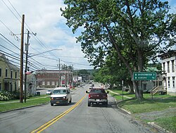
Along westbound Main Street
USA New York location map.svg
Red pog.svg
West Winfield
Usa edcp location map.svg
Red pog.svg
West Winfield
Coordinates: 42°53′4″N75°11′31″W / 42.88444°N 75.19194°W / 42.88444; -75.19194
CountryUnited States
State New York
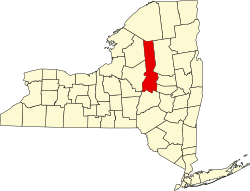
County Herkimer
Town Winfield
Government
  MayorAndrew Bryce
Area
[1]
  Total0.91 sq mi (2.36 km2)
  Land0.91 sq mi (2.36 km2)
  Water0.00 sq mi (0.00 km2)
Elevation
1,191 ft (363 m)
Population
 (2020)
  Total733
  Density804.61/sq mi (310.59/km2)
Time zone UTC-5 (Eastern (EST))
  Summer (DST) UTC-4 (EDT)
ZIP code
13491
Area code 315
FIPS code 36-81292 [2]
GNIS feature ID0970891 [3]
Website www.westwinfield.org

West Winfield is a village in the town of Winfield in Herkimer County, New York, United States. The population was 826 at the 2010 census. [2] The village is indirectly named after General Winfield Scott.[ citation needed ] The village is south of Utica.

Contents

History

An early school in the town, the West Winfield Academy (Mt. Markham), was established in 1850.

The Bonfoy–Barstow House was listed on the National Register of Historic Places in 2011. [4]

Geography

According to the United States Census Bureau, the village has a total area of 0.91 square miles (2.36 km2), all land. [2]

A branch of the Unadilla River, a tributary of the Susquehanna River, flows through the village.

The village is on U.S. Route 20 (Main Street) at the junction of New York State Route 51 (South Street). US-20 leads east 11 miles (18 km) to Richfield Springs and west 3 miles (5 km) to Bridgewater. NY-51 leads south 12 miles (19 km) to Burlington Flats. Utica is 17 miles (27 km) to the north via county roads.

Demographics

Historical population
CensusPop.Note
1880 594
1890 74124.7%
1900 7714.0%
1910 726−5.8%
1920 725−0.1%
1930 7797.4%
1940 754−3.2%
1950 83210.3%
1960 96015.4%
1970 1,0186.0%
1980 979−3.8%
1990 871−11.0%
2000 862−1.0%
2010 826−4.2%
2020 733−11.3%
U.S. Decennial Census [5]

As of the census [6] of 2000, there were 862 people, 352 households, and 241 families residing in the village. The population density was 959.3 inhabitants per square mile (370.4/km2). There were 372 housing units at an average density of 414.0 per square mile (159.8/km2). The racial makeup of the village was 99.65% White, 0.23% Asian and 0.12% Pacific Islander. Hispanic or Latino of any race were 0.12% of the population.

There were 352 households, out of which 27.6% had children under the age of 18 living with them, 53.1% were married couples living together, 11.4% had a female householder with no husband present, and 31.5% were non-families. 29.0% of all households were made up of individuals, and 19.9% had someone living alone who was 65 years of age or older. The average household size was 2.45 and the average family size was 3.00.

In the village, the population was spread out, with 26.0% under the age of 18, 7.0% from 18 to 24, 20.9% from 25 to 44, 25.5% from 45 to 64, and 20.6% who were 65 years of age or older. The median age was 41 years. For every 100 females, there were 88.2 males. For every 100 females age 18 and over, there were 84.9 males.

The median income for a household in the village was $33,947, and the median income for a family was $42,031. Males had a median income of $26,793 versus $23,500 for females. The per capita income for the village was $16,465. About 7.6% of families and 9.1% of the population were below the poverty line, including 11.9% of those under age 18 and 8.4% of those age 65 or over.

Schools

The village is within the Mt. Markham Central School District. The Mt. Markham Middle School is located within the village, however the high school and elementary school are located just outside the village but still within the town of Winfield.

Notable people

Related Research Articles

<span class="mw-page-title-main">Judith Basin County, Montana</span> County in Montana, United States

Judith Basin County is a county in the U.S. state of Montana. As of the 2020 census, the population was 2,023. Its county seat is the town of Stanford.

<span class="mw-page-title-main">Mount Union, Iowa</span> Census-designated place in Iowa, United States

Mount Union is an unincorporated community and census-designated place (CDP) in Henry County, Iowa, United States. It was formerly a city, but in a November 2016 referendum residents voted 32 to 31 to unincorporate. The 2010 census reported the city population to be 107.

<span class="mw-page-title-main">Winfield, Iowa</span> City in Iowa, United States

Winfield is a city in Henry County, Iowa, United States. The population was 1,033 at the time of the 2020 census.

<span class="mw-page-title-main">Roseville, Michigan</span> City in Michigan, United States

Roseville is a city in Macomb County in the U.S. state of Michigan. A northern suburb of Detroit, Roseville is located roughly 13 miles (20.9 km) northeast of downtown Detroit. As of the 2020 census, the city had a population of 47,710.

<span class="mw-page-title-main">Utica, Michigan</span> City in Michigan, United States

Utica is a city in Macomb County in the U.S. state of Michigan. The population was 5,245 at the 2020 census, up from 4,757 in 2010.

<span class="mw-page-title-main">Lakeview, Michigan</span> Village in Michigan, United States

Lakeview is a village in Cato Township in Montcalm County of the U.S. state of Michigan. The population was 1,024 at the 2020 census.

<span class="mw-page-title-main">Learned, Mississippi</span> Town in Mississippi, United States

Learned is a town in Hinds County, Mississippi, United States.

<span class="mw-page-title-main">Utica, Mississippi</span> Town in Mississippi, United States

Utica is a town in Hinds County, Mississippi, United States. The population was 820 at the 2010 census, down from 966 at the 2000 census. Utica is part of the Jackson Metropolitan Statistical Area.

<span class="mw-page-title-main">Utica, Missouri</span> Village in Missouri, United States

Utica is a village in Livingston County, Missouri, United States. The population was 222 at the 2020 census.

<span class="mw-page-title-main">Utica, Nebraska</span> Village in Seward County, Nebraska, United States

Utica is a village in Seward County, Nebraska, United States. It is part of the Lincoln, Nebraska Metropolitan Statistical Area. The population was 861 at the 2010 census.

<span class="mw-page-title-main">Middleville, New York</span> Village in New York, United States

Middleville is a village in Herkimer County, New York, United States. The population was 512 at the 2010 census.

Mohawk is a village in Herkimer County, New York, United States. The population was 2,731 at the 2010 census. The village was named after the adjacent Mohawk River.

<span class="mw-page-title-main">Winfield (town), New York</span> Town in New York, United States

Winfield is a town in Herkimer County, New York, United States. The population was 2,086 at the 2010 census. The town is named after General Winfield Scott and is in the southwestern corner of the county, south of Utica.

<span class="mw-page-title-main">Teays Valley, West Virginia</span> Census-designated place in West Virginia, United States

Teays Valley is a census-designated place in Putnam County, West Virginia, United States. The population was 14,350 at the 2020 census. Located about 20 miles (32 km) west of Charleston and 30 miles (48 km) east of Huntington, it is part of the Huntington–Ashland metropolitan area.

<span class="mw-page-title-main">Winfield, West Virginia</span> City in West Virginia, United States

Winfield is a city in and the county seat of Putnam County, West Virginia, United States, located along the Kanawha River. The population was 2,397 at the 2020 census. It is part of the Huntington–Ashland metropolitan area.

<span class="mw-page-title-main">Utica, Ohio</span> Village in Ohio, United States

Utica is a village in Knox and Licking counties in the U.S. state of Ohio, along the North Fork of the Licking River. The population was 2,064 at the 2020 census.

New Berlin is a village in Chenango County, New York, United States. The population was 1,028 at the 2010 census. The village is by the eastern town line of the town of New Berlin and is northeast of Norwich.

<span class="mw-page-title-main">Sherburne (village), New York</span> Village in New York, United States

Sherburne is a village in Chenango County, New York, United States. The population was 1,367 at the 2010 census. It is in the town of Sherburne, north of Norwich.

<span class="mw-page-title-main">Sullivan, Wisconsin</span> Village in Wisconsin, United States

Sullivan is a village in Jefferson County, Wisconsin, United States. The population was 651 at the 2020 census. The village is located within the Town of Sullivan, and is known to residents of southern Wisconsin including the Madison and Milwaukee metro areas as the location of the National Weather Service forecast office MKX, although its mailing address is in nearby Dousman.

<span class="mw-page-title-main">Washington Township, Macomb County, Michigan</span> Charter township in Michigan, United States

Washington Charter Township, located within Metro Detroit, is a charter township of Macomb County in the U.S. state of Michigan. The population was 28,165 at the 2020 census, up from 25,139 in 2010.

References

  1. "ArcGIS REST Services Directory". United States Census Bureau. Retrieved September 20, 2022.
  2. 1 2 3 "Geographic Identifiers: 2010 Census Summary File 1 (G001): West Winfield village, New York". American Factfinder. U.S. Census Bureau. Archived from the original on February 13, 2020. Retrieved December 6, 2017.
  3. "US Board on Geographic Names". United States Geological Survey. October 25, 2007. Retrieved January 31, 2008.
  4. "National Register of Historic Places". WEEKLY LIST OF ACTIONS TAKEN ON PROPERTIES: 8/22/11 THROUGH 8/26/11. National Park Service. September 2, 2011.
  5. "Census of Population and Housing". Census.gov. Retrieved June 4, 2015.
  6. "U.S. Census website". United States Census Bureau . Retrieved January 31, 2008.