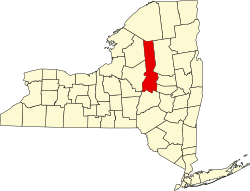
Nobleboro, New York

Last updated

Nobleboro, New York
USA New York location map.svg
Red pog.svg
Nobleboro
Usa edcp location map.svg
Red pog.svg
Nobleboro
Coordinates: 43°23′45″N74°51′43″W / 43.39583°N 74.86194°W / 43.39583; -74.86194
CountryUnited States
State New York
County Herkimer
Town Ohio
Elevation
1,430 [1]  ft (436 m)
Time zone UTC-5 (Eastern (EST))
  Summer (DST) UTC-4 (EDT)
ZIP code
13324
Area code(s) 315

Nobleboro, formally known as Noblesboro, is a hamlet located in the town of Ohio in Herkimer County, New York, United States. The South Branch West Canada Creek converges with the West Canada Creek in the hamlet.

The name "Noblesboro", now Nobleboro, is derived from its situation at the boundary of a royal grant to Sir William Johnson.[ citation needed ] The remains of a pulpwood boom and rossing mill on West Canada Creek, are located in Nobleboro and is commemorated today with a scenic overlook and kiosk.[ citation needed ]

Related Research Articles

<span class="mw-page-title-main">Caroga, New York</span> Town in New York, United States

Caroga is a town in Fulton County, New York, United States. The population was 1,205 at the 2010 census. The town was named after a local creek.

<span class="mw-page-title-main">Wells, New York</span> Town in New York, United States

Wells is a town in Hamilton County, New York, United States. The population was 674 at the 2010 census. The town is named after Joshua Wells, a land agent, who built the first mills in the area. It is in the Adirondack Park and on the eastern border of the county. It is northwest of Schenectady.

<span class="mw-page-title-main">Ohio, New York</span> Town in New York, United States

Ohio is a town in Herkimer County, New York, United States. The population was 1,002 at the 2010 census. The town is named after the state of Ohio. The town is in the northern part of the county and northeast of Utica. Part of Ohio is within the Adirondack Park.

<span class="mw-page-title-main">Russia, New York</span> Town in New York, United States

Russia is a town in Herkimer County, New York, United States. The population was 2,269 at the 2020 census, down from 2,587 in 2010. The town is located in the northwestern part of the county and is northeast of Utica.

<span class="mw-page-title-main">Maryland, New York</span> Town in New York, United States

Maryland is a town in Otsego County, New York, United States. The population was 1,897 at the 2010 census. It was named for the U.S. state of the same name. The Town of Maryland is on the county's southern border. It is northeast of the City of Oneonta.

<span class="mw-page-title-main">Shawangunk, New York</span> Town in New York, United States

Shawangunk is a town in southwestern Ulster County, New York, United States. The population was 13,563 at the 2020 census. The town takes its name from its largest stream, the Shawangunk Kill. The name Shawangunk is from the language of the Lenape people. Kill is an abbreviation of the Dutch word for creek, Killitje. It is pronounced Shuh-Whan-Gung

<span class="mw-page-title-main">Hebron, New York</span> Town in New York, United States

Hebron is a town in Washington County, New York, United States. It is part of the Glens Falls Metropolitan Statistical Area. The town population was 1,773 at the 2000 census. The town is named after the ancient city of Hebron, in the present-day West Bank.

<span class="mw-page-title-main">Mohawk River</span> River in the U.S. state of New York

The Mohawk River is a 149-mile-long (240 km) river in the U.S. state of New York. It is the largest tributary of the Hudson River. The Mohawk flows into the Hudson in Cohoes, New York, a few miles north of the state capital of Albany. The river is named for the Mohawk Nation of the Iroquois Confederacy. A major waterway, in the early 19th century, the river's east-west valley provided the setting and water for development of the Erie Canal, as a key to developing New York. The largest tributary, the Schoharie Creek, accounts for over one quarter (26.83%) of the Mohawk River's watershed. Another main tributary is the West Canada Creek, which makes up for 16.33% of the Mohawk's watershed.

<span class="mw-page-title-main">Missisquoi River</span> River in Canada, United States

The Missisquoi River is a transboundary river of the east shore of Lake Champlain, approximately 80 miles (130 km) long, in northern Vermont in the United States and southern Quebec in Canada.

<span class="mw-page-title-main">West Canada Creek</span> River in New York, United States

The West Canada Creek is a 76-mile-long (122 km) river in upstate New York, United States. West Canada Creek is an important water way in Hamilton, Oneida, and Herkimer counties, draining the south part of the Adirondack Mountains before emptying into the Mohawk River near the Village of Herkimer. The name "Canada" is derived from an Iroquoian word for "village" (Kanata).

<span class="mw-page-title-main">Division No. 4, Saskatchewan</span> Census division of Saskatchewan, Canada

Division No. 4 is one of eighteen census divisions in the province of Saskatchewan, Canada, as defined by Statistics Canada. It is located in the southwest corner of the province, bordering Alberta to the west and Montana, United States to the south. The most populous community in this division is Maple Creek.

Sprout Brook is a hamlet in the Town of Canajoharie in Montgomery County, New York, United States. It is located 60 miles (97 km) west of Albany. New York State Route 163 (NY 163) passes through the hamlet, as does Bowmans Creek.

Honnedaga Brook is a stream in the Adirondack Mountains of the U.S. state of New York. It starts at Honnedaga Lake and flows into West Canada Creek about 7 miles (11 km) upstream of Nobleboro, New York.

South Branch West Canada Creek empties into the West Canada Creek by Nobleboro, New York.

Cattown is a hamlet located at the corner of Cattown and Hoke Roads in the Town of Otsego, New York, in Otsego County, United States. It is west of Fly Creek and north of Oaksville. The hamlet was named Cattown because a girl's husband dropped a cat down a chimney of a house to break up a meeting she was attending because his dinner was late.

Seabury Brook flows into West Canada Creek a few miles upstream of Nobleboro, New York in Herkimer County, New York.

Big Brook flows into West Canada Creek a few miles upstream of Nobleboro, New York, in Herkimer County, New York.

Mill Creek flows into West Canada Creek in Nobleboro, New York, in Herkimer County, New York.

Metcalf Brook flows into West Canada Creek a few miles upstream of Nobleboro in Hamilton County, New York.

Betty Green Brook flows into West Canada Creek north of Nobleboro in Herkimer County, New York.

References

  1. "Nobleboro". Geographic Names Information System . United States Geological Survey, United States Department of the Interior . Retrieved November 5, 2017.