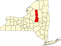
North Wilmurt, New York

Last updated

North Wilmurt, New York
USA New York location map.svg
Red pog.svg
North Wilmurt
Usa edcp location map.svg
Red pog.svg
North Wilmurt
Coordinates: 43°26′59″N75°01′00″W / 43.44972°N 75.01667°W / 43.44972; -75.01667
CountryUnited States
State New York
County Herkimer
Town Ohio
Elevation
1,621 [1]  ft (494 m)
Time zone UTC-5 (Eastern (EST))
  Summer (DST) UTC-4 (EDT)
ZIP code
13324
Area code(s) 315

North Wilmurt is a hamlet located on Farr Road in the town of Ohio in Herkimer County, New York, United States. Twin Lakes Stream flows west through the hamlet. [2]

Related Research Articles

<span class="mw-page-title-main">Ohio, New York</span> Town in New York, United States

Ohio is a town in Herkimer County, New York, United States. The population was 1,002 at the 2010 census. The town is named after the state of Ohio. The town is in the northern part of the county and northeast of Utica. Part of Ohio is within the Adirondack Park.

<span class="mw-page-title-main">Chugach Mountains</span> Mountains in southern Alaska

The Chugach Mountains of southern Alaska are the northernmost of the several mountain ranges that make up the Pacific Coast Ranges of the western edge of North America. The range is about 250 miles (402 km) long and 60 miles (97 km) wide, and extends from the Knik and Turnagain Arms of the Cook Inlet on the west to Bering Glacier, Tana Glacier, and the Tana River on the east. It is bounded on the north by the Matanuska, Copper, and Chitina rivers. The highest point of the Chugach Mountains is Mount Marcus Baker, at 13,094 feet (3,991 m), but with an average elevation of 4,006 feet (1,221 m), most of its summits are not especially high. Even so, its position along the Gulf of Alaska ensures more snowfall in the Chugach than anywhere else in the world, an annual average of over 1500 cm (800 in).

Lake Pleasant is a lake located in the Adirondack Park in New York in the United States. The lake is in the town of Lake Pleasant in Hamilton County.

<span class="mw-page-title-main">Chippewa River (Michigan)</span> River in Michigan, United States

The Chippewa River is a stream in Michigan, United States, that runs 91.8 miles (147.7 km) through the central Lower Peninsula. The Chippewa is a tributary of the Tittabawassee River and is thus part of the Saginaw River drainage basin. The river is named after the Chippewa people.

<span class="mw-page-title-main">West Canada Creek</span> River in New York, United States

The West Canada Creek is a 76-mile-long (122 km) river in upstate New York, United States. West Canada Creek is an important water way in Hamilton, Oneida, and Herkimer counties, draining the south part of the Adirondack Mountains before emptying into the Mohawk River near the Village of Herkimer. The name "Canada" is derived from an Iroquoian word for "village" (Kanata).

Black River is a 29.8-mile-long (48.0 km) river on the Upper Peninsula of the U.S. state of Michigan. The river flows into the Middle Branch Escanaba River in Ely Township of Marquette County at 46°23′53″N87°46′15″W and on into Lake Michigan.

East Ongul Island is an island in the Flatvaer Islands off of Antarctica. It is 2 kilometres (1 nmi) long, lying immediately east of the northern part of Ongul Island at the east side of the entrance of Lutzow-Holm Bay.

<span class="mw-page-title-main">Pine River (Chippewa River tributary)</span> River in the United States

The Pine River is a 103-mile-long (166 km) river in the Lower Peninsula of the U.S. state of Michigan. The Pine River is a tributary of the Chippewa River and is thus part of the Saginaw River drainage basin.

The Little Salmon River is a tributary of Lake Ontario located in Oswego County, New York. The river enters Lake Ontario approximately four miles (6.4 km) southwest from the mouth of the Salmon River.

Twin Lakes Stream drains Twin Lakes and flows into the Black River near North Wilmurt, New York.

Metcalf Lake is a lake located northeast of Hoffmeister, New York. Fish species present in the lake are brook trout, and black bullhead. There is trail off Wilmurt Lake Road. No motors are allowed on this lake.

Twin Lakes Inlet flows into Twin Lakes northeast of North Wilmurt, New York.

Canachagala Mountain is a summit located in Central New York Region of New York located in the Town of Ohio in Herkimer County, north of Wilmurt. Canachagala Lake is located north of Canachagala Mountain.

Stone Dam Mountain is a summit located in Central New York Region of New York located in the Town of Ohio in Herkimer County, northwest of North Wilmurt. Stone Dam Lake is located east of the elevation.

<span class="mw-page-title-main">Indian Lake (hamlet), New York</span> Hamlet in New York, United States

Indian Lake is a hamlet located in the Town of Indian Lake in Hamilton County, New York, United States. Adirondack Lake is located northeast of the hamlet and Indian Lake is located south of the hamlet. NY 28 and NY 30 run through the hamlet.

Butler Lake is a small lake south of Wilmurt in Herkimer County, New York. It drains north via an unnamed creek that flows into West Canada Creek. Butler Lake is home to a pair of loons who migrate in each spring to rear their young. The lake is only just large enough as they require a "long runway" of water from which to take off. Atwood Lake is located east of Butler Lake.

Buck Pond is a small lake north-northwest of the hamlet of North Wilmurt in Herkimer County, New York. It drains south via an unnamed creek that flows into Woodhull Creek.

Mad Tom Lake is a lake north of Wilmurt in Herkimer County, New York. It drains southwest via Mad Tom Brook which flows into the West Canada Creek.

References

  1. "North Wilmurt". Geographic Names Information System . United States Geological Survey, United States Department of the Interior . Retrieved October 4, 2017.
  2. "Twin Lakes Stream". Geographic Names Information System . United States Geological Survey, United States Department of the Interior . Retrieved October 4, 2017.