Danube, New York

Last updated
Danube, New York
Danube Herkimer NY.png
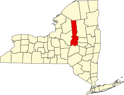
Location within Herkimer County
USA New York location map.svg
Red pog.svg
Danube
Usa edcp location map.svg
Red pog.svg
Danube
Coordinates: 42°59′17″N74°48′9″W / 42.98806°N 74.80250°W / 42.98806; -74.80250
CountryUnited States
State New York
County Herkimer
Government
  Type Town Council
   Town Supervisor Rick Mosher
   Town Council
Members' List
Area
[1]
  Total29.61 sq mi (76.70 km2)
  Land29.35 sq mi (76.03 km2)
  Water0.26 sq mi (0.67 km2)
Elevation
443 ft (135 m)
Population
 (2010)
  Total1,039
  Estimate 
(2019) [2]
1,020
  Density34.85/sq mi (13.46/km2)
Time zone UTC-5 (Eastern (EST))
  Summer (DST) UTC-4 (EDT)
FIPS code 36-043-19686
GNIS feature ID0978885
Website www.town.danube.ny.us

Danube is a town in Herkimer County, New York, United States. The population was 1,039 at the 2010 census. [3] Early Palatine German immigrants in the eighteenth century named the town after the Danube River [4] in Europe.

Contents

The town is in southeastern Herkimer County, southeast of the city of Little Falls and south of the Mohawk River.

History

The town was first settled by Europeans around 1730 on the territories of Lindsey's (1730) and Van Horne's (1731) patents. The town was within the territory of the Mohawk people.

In coordination with the colonial government the Mohawk had allowed a fortified settlement east of here. They had agreed in 1712 to allow some settlement by Palatine Germans in exchange for Queen Anne helping with their defense against the French and Indian allies. Fort Schuyler was constructed south of the Mohawk River near one of their major settlements at the time.

The town of Danube was formed in 1817 from the town of Minden (in Montgomery County). Part of Danube was taken off in 1828 to form the town of Stark.

The Herkimer Home and Mohawk Upper Castle Historic District are listed on the National Register of Historic Places. [5]

Notable people

Geography

According to the United States Census Bureau, the town has a total area of 29.6 square miles (76.7 km2), of which 29.3 square miles (76.0 km2) are land and 0.3 square miles (0.7 km2), or 0.87%, are water. [3]

The eastern town line is the border of Montgomery County. The northern town boundary is marked by the Mohawk River and the Erie Canal.

The New York State Thruway (Interstate 90) passes across the northern part of the town. New York State Route 5S is an east–west highway that parallels the Thruway. New York State Route 169 intersects NY-5S and the Thruway in the northwestern part of Danube.

Demographics

Historical population
CensusPop.Note
1820 3,187
1830 1,723−45.9%
1840 1,96013.8%
1850 1,730−11.7%
1860 1,711−1.1%
1870 1,324−22.6%
1880 1,235−6.7%
1890 1,116−9.6%
1900 1,043−6.5%
1910 941−9.8%
1920 746−20.7%
1930 7905.9%
1940 8497.5%
1950 847−0.2%
1960 9117.6%
1970 1,01511.4%
1980 1,0816.5%
1990 1,077−0.4%
2000 1,0981.9%
2010 1,039−5.4%
2019 (est.)1,020 [2] −1.8%
U.S. Decennial Census [6]

As of the census [7] of 2000, there were 1,098 people, 398 households, and 280 families residing in the town. The population density was 37.4 inhabitants per square mile (14.4/km2). There were 442 housing units at an average density of 15.0 per square mile (5.8/km2). The racial makeup of the town was 96.90% White, 0.82% African American, 0.36% Native American, 0.91% Asian, 0.09% from other races, and 0.91% from two or more races. Hispanic or Latino of any race were 0.91% of the population.

There were 398 households, out of which 35.9% had children under the age of 18 living with them, 52.8% were married couples living together, 9.3% had a female householder with no husband present, and 29.6% were non-families. 23.6% of all households were made up of individuals, and 9.8% had someone living alone who was 65 years of age or older. The average household size was 2.76 and the average family size was 3.22.

In the town, the population was spread out, with 31.1% under the age of 18, 6.6% from 18 to 24, 28.8% from 25 to 44, 22.8% from 45 to 64, and 10.8% who were 65 years of age or older. The median age was 35 years. For every 100 females, there were 111.6 males. For every 100 females age 18 and over, there were 112.0 males.

The median income for a household in the town was $31,815, and the median income for a family was $32,500. Males had a median income of $28,661 versus $20,000 for females. The per capita income for the town was $13,572. About 15.5% of families and 18.4% of the population were below the poverty line, including 27.8% of those under age 18 and 6.2% of those age 65 or over.

Communities

Related Research Articles

Oppenheim is a town in Fulton County, New York, United States. The town is in the southwestern corner of the county and is east of Utica. The population was 1,924 at the 2010 census.

<span class="mw-page-title-main">Fairfield, New York</span> Town in New York, United States

Fairfield is a town in Herkimer County, New York, United States. The population was 1,627 at the 2010 census. The town is named after Fairfield, Connecticut.

<span class="mw-page-title-main">German Flatts, New York</span> Town in Herkimer County, New York, US

German Flatts is a town in Herkimer County, New York, United States. The population was 13,258 at the 2010 census.

<span class="mw-page-title-main">Manheim, New York</span> Town in New York, United States

Manheim is a town in Herkimer County, New York, United States. The population was 3,334 at the 2010 census. The town name is derived from Mannheim in Baden, Germany.

<span class="mw-page-title-main">Middleville, New York</span> Village in New York, United States

Middleville is a village in Herkimer County, New York, United States. The population was 512 at the 2010 census.

<span class="mw-page-title-main">Norway, New York</span> Town in New York, United States

Norway is a town in Herkimer County, New York, United States. The population was 762 at the 2010 census. The town is located in the central part of the county and is northeast of Utica.

<span class="mw-page-title-main">Schuyler, New York</span> Town in Herkimer County, New York, US

Schuyler is a town in Herkimer County, New York, United States. The population was 3,420 at the 2010 census. The town is in the western part of Herkimer County and is east of Utica.

<span class="mw-page-title-main">Stark, New York</span> Town in New York, United States

Stark is a town in Herkimer County, New York, United States. The population was 757 at the 2010 census. The town was named after Revolutionary War general John Stark.

<span class="mw-page-title-main">Winfield (town), New York</span> Town in New York, United States

Winfield is a town in Herkimer County, New York, United States. The population was 2,086 at the 2010 census. The town is named after General Winfield Scott and is in the southwestern corner of the county, south of Utica. "The town has recently been certified a Clean Energy Community."

<span class="mw-page-title-main">Glen, New York</span> Town in New York, United States

Glen is a town in Montgomery County, New York, United States. The population was 2,507 at the 2010 census. The town was named after Jacob Glen, an early landowner.

<span class="mw-page-title-main">Minden, New York</span> Town in New York, United States

Minden is a town in Montgomery County, New York, United States. The population was 4,297 at the 2010 census. The town is located at the western edge of the county and south of the Mohawk River, which forms its northern border. It has possessed a post office from 1802 to 1903.

<span class="mw-page-title-main">Deerfield, New York</span> Town in New York, United States

Deerfield is a town in Oneida County, New York, United States. The population was 4,273 at the 2010 census.

<span class="mw-page-title-main">Marcy, New York</span> Town in New York, United States

Marcy is a town in Oneida County, New York, United States. The population was 8,982 at the 2010 census. The town was named after Governor William L. Marcy. It lies between the cities of Rome and Utica. The Erie Canal passes through the southern part of the town.

<span class="mw-page-title-main">Frankfort (town), New York</span> Town in New York, United States

Frankfort is a town in Herkimer County, New York, United States. The town is named after one of its earliest settlers, Lawrence (Lewis) Frank. The town of Frankfort includes a village, also called Frankfort. Frankfort is located east of Utica, and the Erie Canal passes along its northern border. At the time of the 2010 census, the population was 7,636.

<span class="mw-page-title-main">Herkimer (town), New York</span> Town in New York, United States

Herkimer is a town in Herkimer County, New York, United States, southeast of Utica. It is named after Nicholas Herkimer. The population was 10,175 at the 2010 census.

<span class="mw-page-title-main">Little Falls (town), New York</span> Town in New York, United States

Little Falls is a town in Herkimer County, New York, United States. The population was 1,587 at the 2010 census. The town is named after falls and rapids on the Mohawk River nearby.

<span class="mw-page-title-main">Newport, New York</span> Town in New York, United States

Newport is a town in Herkimer County, New York, United States. The population was 2,302 at the 2010 census. The town, located on the western edge of the county, contains the village of Newport. The town is northeast of Utica.

<span class="mw-page-title-main">Amsterdam (town), New York</span> Town in New York, United States

Amsterdam is a town in Montgomery County, New York, United States. The population was 5,566 at the 2010 census. The town is named after Amsterdam, the capital of the Netherlands.

<span class="mw-page-title-main">Rotterdam, New York</span> Town in New York, United States

Rotterdam is a town in Schenectady County, New York, United States. The population was 30,523 at the 2020 census.

<span class="mw-page-title-main">Plattekill (town), New York</span> Place in New York, United States

Plattekill is a town in Ulster County, New York, United States. The population was 10,424 in 2020, a slight decrease from 10,499 at the 2010 census. The name is derived from a stream, the Platte Kill.

References

  1. "2016 U.S. Gazetteer Files". United States Census Bureau. Retrieved Jul 5, 2017.
  2. 1 2 "Population and Housing Unit Estimates" . Retrieved November 10, 2020.
  3. 1 2 "Geographic Identifiers: 2010 Census Summary File 1 (G001): Danube town, Herkimer County, New York". American Factfinder. U.S. Census Bureau. Archived from the original on February 13, 2020. Retrieved November 28, 2017.
  4. Gannett, Henry (1905). The Origin of Certain Place Names in the United States. Govt. Print. Off. pp.  99.
  5. "National Register Information System". National Register of Historic Places . National Park Service. July 9, 2010.
  6. "Census of Population and Housing". Census.gov. Retrieved June 4, 2015.
  7. "U.S. Census website". United States Census Bureau . Retrieved 2008-01-31.
  8. "National Register Information System". National Register of Historic Places . National Park Service. March 13, 2009.