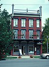
[3] Name on the Register Image Date listed [4] Location City or town Description 1 Abingdon and New Abingdon Apartments Upload image November 9, 2018 (# 100003114 327 Holcomb & 270-272 Mullin Sts. 43°58′18″N 75°55′09″W / 43.971737893462986°N 75.9190930816933°W / 43.971737893462986; -75.9190930816933 (Abingdon and New Abingdon Apartments ) Watertown First purpose-built apartment buildings in city, dating to 1908–10 2 Adams Commercial Historic District Adams Commercial Historic District September 29, 2006 (# 06000882 Main and North Main Sts. and portions of East and West Church Sts. 43°48′32″N 76°01′28″W / 43.808889°N 76.024444°W / 43.808889; -76.024444 (Adams Commercial Historic District ) Adams 3 Levi Anthony Building Upload image September 27, 1985 (# 85002451 Broadway 44°07′47″N 76°19′47″W / 44.129722°N 76.329722°W / 44.129722; -76.329722 (Levi Anthony Building ) Cape Vincent part of the Cape Vincent Town and Village Multiple Resource Area (MRA) 4 William Archer House William Archer House November 19, 1980 (# 80002623 112 Washington St. 44°00′11″N 75°58′56″W / 44.003056°N 75.982222°W / 44.003056; -75.982222 (William Archer House ) Brownville part of the Stone Houses of Brownville Thematic Resource (TR) 5 Aubertine Building Aubertine Building September 27, 1985 (# 85002452 Broadway 44°07′45″N 76°19′55″W / 44.129167°N 76.331944°W / 44.129167; -76.331944 (Aubertine Building ) Cape Vincent part of the Cape Vincent Town and Village MRA 6 Samuel F. Ballard House Upload image October 19, 2022 (# 100006515 15811 Cty. Rd. 64 43°53′49″N 75°58′29″W / 43.8970°N 75.9747°W / 43.8970; -75.9747 (Samuel F. Ballard House ) Watertown 7 Cyrus Bates House Cyrus Bates House July 14, 2004 (# 04000710 7185 NY 3 43°49′28″N 76°12′08″W / 43.824444°N 76.202222°W / 43.824444; -76.202222 (Cyrus Bates House ) Henderson 8 Bedford Creek Bridge Bedford Creek Bridge October 18, 1989 (# 89001617 Campbell's Point Rd. over Bedford Creek 43°54′32″N 76°07′12″W / 43.908889°N 76.12°W / 43.908889; -76.12 (Bedford Creek Bridge ) Hounsfield part of the Hounsfield MRA 9 Dr. Abner Benton House Dr. Abner Benton House August 23, 1984 (# 84002405 Main St. 44°17′20″N 75°37′36″W / 44.288889°N 75.626667°W / 44.288889; -75.626667 (Dr. Abner Benton House ) Oxbow 10 George C. Boldt Yacht House George C. Boldt Yacht House April 26, 1978 (# 78001853 Northwest of Alexandria Bay on Wellesley Island 44°20′47″N 75°55′37″W / 44.346389°N 75.926944°W / 44.346389; -75.926944 (George C. Boldt Yacht House ) Alexandria Bay G. W. & W. D. Hewitt , architects. 11 John Borland House John Borland House September 27, 1985 (# 85002453 Market St. 44°07′36″N 76°20′12″W / 44.126667°N 76.336667°W / 44.126667; -76.336667 (John Borland House ) Cape Vincent part of the Cape Vincent Town and Village MRA 12 Broadway Historic District Upload image September 27, 1985 (# 85002455 St. Lawrence River, W. edge of Village of Cape Vincent, on Broadway & Tibbetts Point 44°07′26″N 76°20′44″W / 44.123889°N 76.345556°W / 44.123889; -76.345556 (Broadway Historic District ) Cape Vincent part of the Cape Vincent Town and Village MRA 13 Gen. Jacob Brown Mansion Gen. Jacob Brown Mansion November 19, 1980 (# 80002624 Brown Blvd. 44°00′19″N 75°59′00″W / 44.005278°N 75.983333°W / 44.005278; -75.983333 (Gen. Jacob Brown Mansion ) Brownville part of the Stone Houses of Brownville TR 14 Brownville Hotel Upload image November 19, 1980 (# 80002625 Brown Blvd. and W. Main St. 44°00′10″N 75°59′02″W / 44.002778°N 75.983889°W / 44.002778; -75.983889 (Brownville Hotel ) Brownville part of the Stone Houses of Brownville TR 15 James Buckley House James Buckley House September 27, 1985 (# 85002454 Joseph St. 44°07′37″N 76°20′10″W / 44.126944°N 76.336111°W / 44.126944; -76.336111 (James Buckley House ) Cape Vincent part of the Cape Vincent Town and Village MRA 16 E. K. Burnham House E. K. Burnham House September 27, 1985 (# 85002456 565 Broadway 44°07′45″N 76°20′00″W / 44.129167°N 76.333333°W / 44.129167; -76.333333 (E. K. Burnham House ) Cape Vincent part of the Cape Vincent Town and Village MRA 17 Buttermilk Flat Schoolhouse No. 22 Upload image June 28, 1996 (# 96000671 South side of Buttermilk Flat Rd., east of junction with Carter St. Rd., 44°10′23″N 75°56′57″W / 44.173056°N 75.949167°W / 44.173056; -75.949167 (Buttermilk Flat Schoolhouse No. 22 ) Orleans part of the Orleans Multiple Property Submission (MPS) 18 Elisha Camp House Elisha Camp House April 23, 1973 (# 73001196 310 General Smith Dr. 43°56′55″N 76°07′05″W / 43.948611°N 76.118056°W / 43.948611; -76.118056 (Elisha Camp House ) Sackets Harbor 19 Carter Street Schoolhouse No. 21 Upload image June 28, 1996 (# 96000665 Junction of Vaadi and Dog Hill Rds., southwest corner 44°07′11″N 75°57′12″W / 44.119722°N 75.953333°W / 44.119722; -75.953333 (Carter Street Schoolhouse No. 21 ) Orleans part of the Orleans MPS 20 Cedar Grove Cemetery Upload image September 6, 1990 (# 90001324 Washington St. 44°03′51″N 76°08′02″W / 44.064167°N 76.133889°W / 44.064167; -76.133889 (Cedar Grove Cemetery ) Chaumont part of the Lyme MRA 21 Central Garage Central Garage October 18, 1996 (# 96001172 North side of Clayton St., west of junction with Main St., Hamlet of La Fargeville 44°11′41″N 75°58′00″W / 44.194722°N 75.966667°W / 44.194722; -75.966667 (Central Garage ) Orleans part of the Orleans MPS 22 Chaumont Grange Hall and Dairymen's League Building Upload image September 6, 1990 (# 90001337 Main St. 44°03′55″N 76°07′44″W / 44.065278°N 76.128889°W / 44.065278; -76.128889 (Chaumont Grange Hall and Dairymen's League Building ) Chaumont part of the Lyme MRA 23 Chaumont Historic District Upload image September 6, 1990 (# 90001336 Along Main St., roughly between Washington and Church Sts. 44°04′04″N 76°08′00″W / 44.067778°N 76.133333°W / 44.067778; -76.133333 (Chaumont Historic District ) Chaumont part of the Lyme MRA 24 Chaumont House Upload image September 6, 1990 (# 90001341 Main St. 44°04′08″N 76°08′19″W / 44.068889°N 76.138611°W / 44.068889; -76.138611 (Chaumont House ) Chaumont part of the Lyme MRA 25 Chaumont Railroad Station Upload image September 6, 1990 (# 90001332 Main St. 44°04′02″N 76°07′45″W / 44.067222°N 76.129167°W / 44.067222; -76.129167 (Chaumont Railroad Station ) Chaumont part of the Lyme MRA 26 Xavier Chevalier House Upload image September 27, 1985 (# 85002457 Gosier Rd. 44°09′29″N 76°14′27″W / 44.158056°N 76.240833°W / 44.158056; -76.240833 (Xavier Chevalier House ) Cape Vincent part of the Cape Vincent Town and Village MRA 27 Church of Saint Lawrence Church of Saint Lawrence May 16, 1997 (# 97000442 Fuller St., junction with Sisson St. 44°20′11″N 75°55′17″W / 44.336389°N 75.921389°W / 44.336389; -75.921389 (Church of Saint Lawrence ) Alexandria Bay part of the Historic Churches of the Episcopal Diocese of Central New York MPS 28 Clayton Historic District Clayton Historic District September 12, 1985 (# 85002368 203-215 & 200-326 James St., 500-544 & 507-537 Riverside Dr.May 9, 1997 , refnum 97000424): 335, 403, 409, 413, 419, and 435 Riverside Dr. 44°14′31″N 76°05′22″W / 44.241944°N 76.089444°W / 44.241944; -76.089444 (Clayton Historic District ) Clayton 29 Nicholas Cocaigne House Upload image September 27, 1985 (# 85002458 Favret Rd. 44°06′58″N 76°18′45″W / 44.116111°N 76.3125°W / 44.116111; -76.3125 (Nicholas Cocaigne House ) Cape Vincent part of the Cape Vincent Town and Village MRA 30 Conklin Farm Conklin Farm October 18, 1989 (# 89001624 Evans Rd. 43°59′02″N 75°59′29″W / 43.983889°N 75.991389°W / 43.983889; -75.991389 (Conklin Farm ) Hounsfield part of the Hounsfield MRA 31 Cornwall Brothers' Store Cornwall Brothers' Store May 2, 1975 (# 75001191 2 Howell Pl. 44°20′17″N 75°55′11″W / 44.338056°N 75.919722°W / 44.338056; -75.919722 (Cornwall Brothers' Store ) Alexandria Bay 32 Densmore Methodist Church of the Thousand Islands Upload image May 19, 1988 (# 88000591 Rt. 100 at Densmore Bay 44°19′19″N 75°57′15″W / 44.321944°N 75.954167°W / 44.321944; -75.954167 (Densmore Methodist Church of the Thousand Islands ) Alexandria 33 Dexter Universalist Church Dexter Universalist Church September 19, 2003 (# 03000249 Brown and Kirby Sts. 44°00′29″N 76°02′41″W / 44.008056°N 76.044722°W / 44.008056; -76.044722 (Dexter Universalist Church ) Dexter 34 Remy Dezengremel House Upload image September 27, 1985 (# 85002459 Rosiere Rd. 44°06′21″N 76°15′39″W / 44.105833°N 76.260833°W / 44.105833; -76.260833 (Remy Dezengremel House ) Cape Vincent part of the Cape Vincent Town and Village MRA 35 District School No. 19 Upload image October 18, 1989 (# 89001618 Co. Rd. 69 43°55′29″N 76°01′53″W / 43.924722°N 76.031389°W / 43.924722; -76.031389 (District School No. 19 ) Hounsfield part of the Hounsfield MRA 36 District School No. 20 Upload image October 18, 1989 (# 89001619 NY 3, south of Co. Rd. 75 43°55′34″N 76°06′32″W / 43.926111°N 76.108889°W / 43.926111; -76.108889 (District School No. 20 ) Hounsfield part of the Hounsfield MRA 37 District School No. 3 Upload image September 6, 1990 (# 90001326 Junction of NY 3 and County Rd. 57, Putnam Corners 44°04′09″N 76°14′18″W / 44.069167°N 76.238333°W / 44.069167; -76.238333 (District School No. 3 ) Lyme part of the Lyme MRA 38 Joseph Docteur House Upload image September 27, 1985 (# 85002460 Rosiere Rd. 44°07′06″N 76°13′52″W / 44.118333°N 76.231111°W / 44.118333; -76.231111 (Joseph Docteur House ) Cape Vincent part of the Cape Vincent Town and Village MRA 39 Duvillard Mill Duvillard Mill September 27, 1985 (# 85002461 Broadway 44°07′49″N 76°19′54″W / 44.130278°N 76.331667°W / 44.130278; -76.331667 (Duvillard Mill ) Cape Vincent part of the Cape Vincent Town and Village MRA 40 Reuter Dyer House Upload image September 27, 1985 (# 85002462 Rosiere Rd. 44°06′12″N 76°17′11″W / 44.103333°N 76.286389°W / 44.103333; -76.286389 (Reuter Dyer House ) Cape Vincent part of the Cape Vincent Town and Village MRA 41 East Charity Shoal Light East Charity Shoal Light March 27, 2008 (# 08000231 Northeast Lake Ontario at US-Canada boundary 9.5 miles (15.3 km) southwest of Cape Vincent 44°02′19″N 76°28′54″W / 44.038611°N 76.481667°W / 44.038611; -76.481667 (East Charity Shoal Light ) Cape Vincent part of the Light Stations of the United States MPS 42 East Hounsfield Christian Church Upload image October 18, 1989 (# 89001621 NY 3 43°58′08″N 75°59′33″W / 43.968889°N 75.9925°W / 43.968889; -75.9925 (East Hounsfield Christian Church ) Hounsfield part of the Hounsfield MRA 43 Emerson Place Emerson Place April 18, 2003 (# 03000241 20-30 Emerson Place 43°58′24″N 75°53′59″W / 43.973333°N 75.899722°W / 43.973333; -75.899722 (Emerson Place ) Watertown 44 Evans-Gaige-Dillenback House Upload image September 6, 1990 (# 90001340 Evans Rd. 44°04′09″N 76°08′13″W / 44.069167°N 76.136944°W / 44.069167; -76.136944 (Evans-Gaige-Dillenback House ) Lyme part of the Lyme MRA 45 Fairview Manor Fairview Manor August 30, 2007 (# 07000866 38289 NY 12-E 44°13′22″N 76°07′18″W / 44.222675°N 76.121608°W / 44.222675; -76.121608 (Fairview Manor ) Clayton 46 First Baptist Church and Cook Memorial Building First Baptist Church and Cook Memorial Building February 9, 2005 (# 05000016 511 State St. 43°58′55″N 75°36′29″W / 43.981944°N 75.608056°W / 43.981944; -75.608056 (First Baptist Church and Cook Memorial Building ) Carthage 47 First Presbyterian Society of Cape Vincent First Presbyterian Society of Cape Vincent February 5, 2013 (# 12001258 260 E. Broadway 44°07′36″N 76°20′23″W / 44.126666°N 76.339737°W / 44.126666; -76.339737 (First Presbyterian Society of Cape Vincent ) Cape Vincent from Cape Vincent Town and Village MRA 48 Roswell P. Flower Memorial Library Roswell P. Flower Memorial Library January 10, 1980 (# 80002628 229 Washington St. 43°58′23″N 75°54′39″W / 43.973056°N 75.910833°W / 43.973056; -75.910833 (Roswell P. Flower Memorial Library ) Watertown 49 Charles Ford House Upload image December 20, 1996 (# 96001472 West side of Ford St., south of junction with Co. Rd. 181, Hamlet of La Fargeville 44°11′36″N 75°58′17″W / 44.193333°N 75.971389°W / 44.193333; -75.971389 (Charles Ford House ) Orleans part of the Orleans MPS 50 Fort Haldimand Site Fort Haldimand Site December 15, 1978 (# 78001854 Address Restricted Cape Vincent 51 Jean Philippe Galband du Fort House Upload image September 27, 1985 (# 85002463 James St. 44°07′34″N 76°20′01″W / 44.126111°N 76.333611°W / 44.126111; -76.333611 (Jean Philippe Galband du Fort House ) Cape Vincent part of the Cape Vincent Town and Village MRA 52 Galloo Island Light Galloo Island Light August 4, 1983 (# 83001682 Galloo Island 43°53′18″N 76°26′40″W / 43.888333°N 76.444444°W / 43.888333; -76.444444 (Galloo Island Light ) Sackets Harbor part of the U.S. Coast Guard Lighthouses and Light Stations on the Great Lakes TR 53 George Brothers Building George Brothers Building September 6, 1990 (# 90001334 Mill St. 44°03′56″N 76°07′47″W / 44.065556°N 76.129722°W / 44.065556; -76.129722 (George Brothers Building ) Chaumont part of the Lyme MRA 54 George House Upload image September 6, 1990 (# 90001338 Washington St. 44°03′57″N 76°08′05″W / 44.065833°N 76.134722°W / 44.065833; -76.134722 (George House ) Chaumont part of the Lyme MRA 55 Getman Farmhouse Upload image September 6, 1990 (# 90001322 S. Shore Rd. 43°58′31″N 76°16′25″W / 43.975278°N 76.273611°W / 43.975278; -76.273611 (Getman Farmhouse ) Lyme part of the Lyme MRA 56 Glen Building Upload image September 27, 1985 (# 85002465 Broadway 44°07′42″N 76°20′03″W / 44.128333°N 76.334167°W / 44.128333; -76.334167 (Glen Building ) Cape Vincent part of the Cape Vincent Town and Village MRA 57 Grenadier Island Schoolhouse Grenadier Island Schoolhouse November 21, 2012 (# 12000955 Grenadier Island Rd. 3 44°02′53″N 76°21′15″W / 44.048112°N 76.354249°W / 44.048112; -76.354249 (Grenadier Island Schoolhouse ) Grenadier Island vicinity 58 Grindstone Island Upper Schoolhouse Upload image August 14, 2012 (# 12000509 41591 Cross Island Rd. 44°16′12″N 76°07′45″W / 44.26998°N 76.129183°W / 44.26998; -76.129183 (Grindstone Island Upper Schoolhouse ) Clayton vicinity 59 Dr. Samuel Guthrie House Dr. Samuel Guthrie House October 18, 1989 (# 89001616 Co. Rd. 75/Military Rd. 43°57′05″N 76°05′36″W / 43.951389°N 76.093333°W / 43.951389; -76.093333 (Dr. Samuel Guthrie House ) Hounsfield part of the Hounsfield MRA 60 Holland Library Holland Library November 15, 2002 (# 02001330 7 Market St. 44°20′11″N 75°55′06″W / 44.336389°N 75.918333°W / 44.336389; -75.918333 (Holland Library ) Alexandria Bay 61 Elijah Horr House Upload image June 28, 1996 (# 96000666 East side of NY 180, north of junction with Woodard Rd., Hamlet of Stone Mills 44°06′49″N 75°58′28″W / 44.113611°N 75.974444°W / 44.113611; -75.974444 (Elijah Horr House ) Orleans part of the Orleans MPS 62 Hiram Hubbard House Upload image September 9, 2009 (# 09000699 34237 NY 126 43°57′41″N 75°41′11″W / 43.961264°N 75.686461°W / 43.961264; -75.686461 (Hiram Hubbard House ) Champion 63 Ingleside Upload image April 16, 1980 (# 80002622 West of Alexandria Bay on Cherry Island 44°19′58″N 75°55′40″W / 44.332778°N 75.927778°W / 44.332778; -75.927778 (Ingleside ) Alexandria Bay 64 Irwin Brothers Store Upload image September 15, 1983 (# 83001681 NY 180 44°06′46″N 75°58′34″W / 44.112778°N 75.976111°W / 44.112778; -75.976111 (Irwin Brothers Store ) Stone Mills 65 Jefferson County Courthouse Complex Jefferson County Courthouse Complex June 7, 1974 (# 74001248 SE corner of Arsenal and Sherman Sts. 43°58′31″N 75°54′51″W / 43.975278°N 75.914167°W / 43.975278; -75.914167 (Jefferson County Courthouse Complex ) Watertown 66 Johnson House Upload image September 27, 1985 (# 85002466 Tibbetts Point Rd. 44°06′22″N 76°21′17″W / 44.106111°N 76.354722°W / 44.106111; -76.354722 (Johnson House ) Cape Vincent part of the Cape Vincent Town and Village MRA 67 Capt. Simon Johnston House Capt. Simon Johnston House June 17, 1982 (# 82003358 507 Riverside Dr. 44°14′31″N 76°05′18″W / 44.241944°N 76.088333°W / 44.241944; -76.088333 (Capt. Simon Johnston House ) Clayton 68 KESTREL (steam yacht) Upload image August 12, 1977 (# 77000873 George C. Boldt Yacht House , Saint Lawrence River 44°20′47″N 75°55′37″W / 44.34639°N 75.92695°W / 44.34639; -75.92695 (KESTREL (steam yacht) ) Alexandria Bay Moored at West New York, New Jersey when listed 69 La Farge Land Office La Farge Land Office June 28, 1996 (# 96000668 Junction of Main and Mill Sts., southwest corner, Hamlet of La Fargeville 44°11′35″N 75°58′03″W / 44.193056°N 75.9675°W / 44.193056; -75.9675 (La Farge Land Office ) Orleans part of the Orleans MPS 70 La Farge Retainer Houses La Farge Retainer Houses August 21, 1997 (# 97000941 Main St., south of junction of Main St. and Ford Rd. 44°11′28″N 75°58′04″W / 44.191111°N 75.967778°W / 44.191111; -75.967778 (La Farge Retainer Houses ) Orleans part of the Orleans MPS 71 La Fargeville United Methodist Church La Fargeville United Methodist Church June 28, 1996 (# 96000670 West side of Main St., south of junction with Co. Rt. 181, Hamlet of La Fargeville 44°11′27″N 75°58′08″W / 44.190833°N 75.968889°W / 44.190833; -75.968889 (La Fargeville United Methodist Church ) Orleans part of the Orleans MPS 72 Lance Farm Upload image September 6, 1990 (# 90001323 S. Shore Rd. 43°58′52″N 76°15′28″W / 43.981111°N 76.257778°W / 43.981111; -76.257778 (Lance Farm ) Lyme part of the Lyme MRA 73 LeRay Hotel Upload image October 29, 1982 (# 82001175 Main and Noble Sts. 44°05′16″N 75°48′28″W / 44.087778°N 75.807778°W / 44.087778; -75.807778 (LeRay Hotel ) Evans Mills 74 LeRay Mansion LeRay Mansion July 11, 1974 (# 74001245 Northeast of Black River on Fort Drum Military Reservation 44°03′00″N 75°45′48″W / 44.05°N 75.763333°W / 44.05; -75.763333 (LeRay Mansion ) Black River 75 Vincent LeRay House Vincent LeRay House November 15, 1973 (# 73001195 Broadway (NY 12E) 44°07′31″N 76°20′34″W / 44.125278°N 76.342778°W / 44.125278; -76.342778 (Vincent LeRay House ) Cape Vincent part of the Cape Vincent Town and Village MRA 76 LeRaysville Archeological District LeRaysville Archeological District November 2, 1995 (# 95000069 Address Restricted Le Ray 77 Lewis House Upload image September 27, 1985 (# 85002467 Market St. 44°07′45″N 76°20′18″W / 44.129167°N 76.338333°W / 44.129167; -76.338333 (Lewis House ) Cape Vincent part of the Cape Vincent Town and Village MRA 78 Longue Vue Island Longue Vue Island November 4, 1982 (# 82001176 St. Lawrence River 44°18′14″N 75°56′25″W / 44.303889°N 75.940278°W / 44.303889; -75.940278 (Longue Vue Island ) Alexandria Bay 79 John Losee House Upload image February 14, 2014 (# 14000004 17100 Cty. Rd. 155 43°55′01″N 75°55′47″W / 43.916896982082065°N 75.92981259188261°W / 43.916896982082065; -75.92981259188261 (John Losee House ) Watertown 80 Madison Barracks Madison Barracks November 21, 1974 (# 74001246 Military Rd. 43°57′10″N 76°06′35″W / 43.952778°N 76.109722°W / 43.952778; -76.109722 (Madison Barracks ) Sackets Harbor 81 Methodist Episcopal Church Methodist Episcopal Church June 28, 1996 (# 96000663 South side of NY 180, west of junction with Gore Rd., Hamlet of Omar 44°15′43″N 75°58′35″W / 44.261944°N 75.976389°W / 44.261944; -75.976389 (Methodist Episcopal Church ) Orleans part of the Orleans MPS 82 Methodist-Protestant Church at Fisher's Landing Methodist-Protestant Church at Fisher's Landing June 28, 1996 (# 96000667 Reed Point Rd., near junction with Co. Rd. 195, Hamlet of Fisher's Landing 44°16′34″N 76°00′33″W / 44.276111°N 76.009167°W / 44.276111; -76.009167 (Methodist-Protestant Church at Fisher's Landing ) Orleans part of the Orleans MPS 83 A. Newton Farm Upload image May 5, 1997 (# 97000356 NY 180, junction with Co. Rd. 13, Hamlet of Omar 44°15′45″N 75°58′44″W / 44.2625°N 75.978889°W / 44.2625; -75.978889 (A. Newton Farm ) Orleans part of the Orleans MPS 84 Norton–Burnham House Norton–Burnham House February 23, 2016 (# 16000034 8748 NY 178 43°50′45″N 76°11′22″W / 43.845799°N 76.189330°W / 43.845799; -76.189330 (Norton–Burnham House ) Henderson 1818 stone house built by early settler was birthplace of City Beautiful movement founder Daniel Burnham 85 Paddock Arcade Paddock Arcade June 15, 1976 (# 76001224 Public Square between Arsenal and Stone Sts. 43°58′28″N 75°54′41″W / 43.974444°N 75.911389°W / 43.974444; -75.911389 (Paddock Arcade ) Watertown 86 Paddock Mansion Paddock Mansion December 11, 1979 (# 79001587 228 Washington St. 43°58′23″N 75°54′43″W / 43.973056°N 75.911944°W / 43.973056; -75.911944 (Paddock Mansion ) Watertown 87 Captain Louis Peugnet House Upload image September 27, 1985 (# 85002469 Tibbetts Point Rd. 44°07′02″N 76°21′13″W / 44.117222°N 76.353611°W / 44.117222; -76.353611 (Captain Louis Peugnet House ) Cape Vincent part of the Cape Vincent Town and Village MRA 88 Pierrepont Manor Complex Upload image September 15, 1977 (# 77000943 North of Mannsville on Ellisburg St. 43°44′04″N 76°03′42″W / 43.734444°N 76.061667°W / 43.734444; -76.061667 (Pierrepont Manor Complex ) Mannsville 89 Point Salubrious Historic District Upload image September 6, 1990 (# 90001339 Point Salubrious Rd. 44°02′34″N 76°09′20″W / 44.042778°N 76.155556°W / 44.042778; -76.155556 (Point Salubrious Historic District ) Lyme part of the Lyme MRA 90 Public Square Historic District Public Square Historic District September 7, 1984 (# 8400240916000110 J.B. Wise & Park Pls., Arcade & Stone Sts., 43°58′28″N 75°54′37″W / 43.974444°N 75.910278°W / 43.974444; -75.910278 (Public Square Historic District ) Watertown 91 Ressequie Farm Upload image October 18, 1989 (# 89001622 Parker Rd. 43°56′05″N 76°02′31″W / 43.934722°N 76.041944°W / 43.934722; -76.041944 (Ressequie Farm ) Hounsfield part of the Hounsfield MRA 92 George Reynolds House Upload image September 27, 1985 (# 85002470 River Rd. 44°09′50″N 76°15′38″W / 44.163889°N 76.260556°W / 44.163889; -76.260556 (George Reynolds House ) Cape Vincent part of the Cape Vincent Town and Village MRA 93 George T. Robinson House Upload image April 17, 2017 (# 100000893 15082 Bluff Island 44°16′09″N 76°04′13″W / 44.26915°N 76.07017°W / 44.26915; -76.07017 (George T. Robinson House ) Clayton 1901 Shingle Style Thousand Island summer house on island in St. Lawrence built by Pittsburgh steel executive for family 94 Rock Island Light Station Rock Island Light Station November 14, 1978 (# 78001855 North of Fishers Landing on Rock Island 44°16′50″N 76°01′03″W / 44.280556°N 76.0175°W / 44.280556; -76.0175 (Rock Island Light Station ) Fishers Landing 95 Rogers Brothers Farmstead Upload image May 11, 1998 (# 98000392 Dablon Point Rd. 44°04′52″N 76°20′59″W / 44.081111°N 76.349722°W / 44.081111; -76.349722 (Rogers Brothers Farmstead ) Cape Vincent part of the Cape Vincent Town and Village MRA 96 John N. Rottiers Farm Upload image September 30, 1996 (# 96001022 East side of NY 180, approximately 2 miles (3.2 km) south of the Hamlet of Lafargeville 44°09′54″N 75°58′29″W / 44.165°N 75.974722°W / 44.165; -75.974722 (John N. Rottiers Farm ) Orleans part of the Orleans MPS 97 The Row Upload image September 6, 1990 (# 90001329 Main St. at Shaver Creek, Three Mile Bay 44°04′49″N 76°12′18″W / 44.080278°N 76.205°W / 44.080278; -76.205 (The Row ) Lyme part of the Lyme MRA 98 Roxy Hotel Roxy Hotel September 27, 1985 (# 85002472 310 Broadway 44°07′39″N 76°20′16″W / 44.1275°N 76.337778°W / 44.1275; -76.337778 (Roxy Hotel ) Cape Vincent part of the Cape Vincent Town and Village MRA 99 Cornelius Sacket House Cornelius Sacket House September 27, 1985 (# 85002473 571 Broadway 44°07′46″N 76°19′58″W / 44.129444°N 76.332778°W / 44.129444; -76.332778 (Cornelius Sacket House ) Cape Vincent part of the Cape Vincent Town and Village MRA 100 General Sacket House General Sacket House September 27, 1985 (# 85002464 4407 James St. 44°07′18″N 76°19′52″W / 44.121667°N 76.331111°W / 44.121667; -76.331111 (General Sacket House ) Cape Vincent part of the Cape Vincent Town and Village MRA 101 Sackets Harbor Battlefield Sackets Harbor Battlefield December 31, 1974 (# 74001247 Coastline and area from Sackets Harbor SW to and including Horse Island 43°56′43″N 76°07′59″W / 43.945278°N 76.133056°W / 43.945278; -76.133056 (Sackets Harbor Battlefield ) Sackets Harbor 102 Sackets Harbor Village Historic District Sackets Harbor Village Historic District September 15, 1983 (# 83001683 Main, Washington, Pike, Edmund, Hill, Hamilton, Broad, and Ambrose Sts. 43°56′44″N 76°07′10″W / 43.945556°N 76.119444°W / 43.945556; -76.119444 (Sackets Harbor Village Historic District ) Sackets Harbor 103 St. John's Episcopal Church St. John's Episcopal Church September 27, 1985 (# 85002476 Market St. 44°07′30″N 76°20′08″W / 44.125°N 76.335556°W / 44.125; -76.335556 (St. John's Episcopal Church ) Cape Vincent part of the Cape Vincent Town and Village MRA 104 St. Paul's Church Upload image August 30, 1996 (# 96000960 210 Washington St. 44°00′18″N 75°58′53″W / 44.005°N 75.981389°W / 44.005; -75.981389 (St. Paul's Church ) Brownville Historic Churches of the Episcopal Diocese of Central New York MPS 105 St. Paul's Episcopal Upload image June 28, 1996 (# 96000669 East side of Main St., south of the junction with Co. Rd. 181, Hamlet of La Fargeville 44°11′26″N 75°58′05″W / 44.190556°N 75.968056°W / 44.190556; -75.968056 (St. Paul's Episcopal ) Orleans part of the Orleans MPS 106 Saint Paul's Episcopal Church Saint Paul's Episcopal Church May 23, 1997 (# 97000413 308-314 Clay St. 43°58′19″N 75°54′28″W / 43.971944°N 75.907778°W / 43.971944; -75.907778 (Saint Paul's Episcopal Church ) Watertown Historic Churches of the Episcopal Diocese of Central New York MPS 107 St. Vincent of Paul Catholic Church St. Vincent of Paul Catholic Church September 27, 1985 (# 85002477 Kanady St. 44°07′28″N 76°20′24″W / 44.124444°N 76.34°W / 44.124444; -76.34 (St. Vincent of Paul Catholic Church ) Cape Vincent part of the Cape Vincent Town and Village MRA 108 Shore Farm Upload image October 18, 1989 (# 89001623 Military Rd., east of Mill Creek 43°57′27″N 76°06′14″W / 43.9575°N 76.103889°W / 43.9575; -76.103889 (Shore Farm ) Hounsfield part of the Hounsfield MRA 109 Stephen Simmons House Upload image October 18, 1989 (# 89001615 Camps Mills Rd., west of Old Slat Points Rd. 43°56′07″N 76°04′28″W / 43.935278°N 76.074444°W / 43.935278; -76.074444 (Stephen Simmons House ) Hounsfield part of the Hounsfield MRA 110 Smith-Ripley House Smith-Ripley House February 13, 2008 (# 08000021 29 E. Church St. 43°48′40″N 76°01′16″W / 43.811111°N 76.021111°W / 43.811111; -76.021111 (Smith-Ripley House ) Adams 111 Star Grange No. 9 Upload image October 18, 1989 (# 89001626 Sulphur Springs Rd. between Jericho and Spencer Rds. 43°55′38″N 76°01′40″W / 43.927222°N 76.027778°W / 43.927222; -76.027778 (Star Grange No. 9 ) Hounsfield part of the Hounsfield MRA 112 Otis Starkey House Otis Starkey House September 27, 1985 (# 85002478 Point St. 44°07′36″N 76°20′06″W / 44.126667°N 76.335°W / 44.126667; -76.335 (Otis Starkey House ) Cape Vincent part of the Cape Vincent Town and Village MRA 113 State Street Historic District State Street Historic District September 22, 1983 (# 83001684 249-401 State St., 246-274 State St. and 106-108 Mechanic St. 43°58′40″N 75°36′36″W / 43.977778°N 75.61°W / 43.977778; -75.61 (State Street Historic District ) Carthage 114 Sterlingville Archeological District Sterlingville Archeological District November 2, 1995 (# 95000070 Address Restricted Philadelphia 115 Stevenson-Frink Farm Upload image October 18, 1989 (# 89001625 Salt Point Rd. 44°00′10″N 76°03′56″W / 44.002778°N 76.065556°W / 44.002778; -76.065556 (Stevenson-Frink Farm ) Hounsfield part of the Hounsfield MRA 116 Stone Mills Union Church Upload image December 12, 1976 (# 76001223 NY 180 near junction with Carter St. 44°06′52″N 75°58′27″W / 44.114444°N 75.974167°W / 44.114444; -75.974167 (Stone Mills Union Church ) Stone Mills 117 Storrs' Harbor Naval Shipyard Site Storrs' Harbor Naval Shipyard Site February 7, 2012 (# 11001091 Address restricted Hounsfield vicinity 118 Old Stone Shop Upload image September 6, 1990 (# 90001328 Main St., Three Mile Bay 44°04′56″N 76°11′50″W / 44.082222°N 76.197222°W / 44.082222; -76.197222 (Old Stone Shop ) Lyme part of the Lyme MRA 119 Byron J. Strough House Upload image January 2, 1997 (# 96001549 South side of Clayton St., west of junction with NY 411, Hamlet of La Fargeville 44°11′41″N 75°58′10″W / 44.194722°N 75.969444°W / 44.194722; -75.969444 (Byron J. Strough House ) Orleans part of the Orleans MPS 120 Sulphur Springs Cemetery Upload image October 18, 1989 (# 89001620 Co. Rd. 62, southwest of Spencer Rd. 43°55′27″N 76°01′54″W / 43.924167°N 76.031667°W / 43.924167; -76.031667 (Sulphur Springs Cemetery ) Hounsfield part of the Hounsfield MRA 121 Swarthout Site-A04507.000038 Swarthout Site-A04507.000038 January 24, 2002 (# 01001504 Address Restricted Clayton 122 Taft House Upload image September 6, 1990 (# 90001297 Main St., Three Mile Bay 44°04′50″N 76°12′11″W / 44.080556°N 76.203056°W / 44.080556; -76.203056 (Taft House ) Lyme part of the Lyme MRA 123 Talcott Falls Site Talcott Falls Site June 5, 1974 (# 74001244 Address Restricted Adams 124 Taylor Boathouse Upload image September 6, 1990 (# 90001330 Bay View Dr., Three Mile Bay 44°04′46″N 76°12′02″W / 44.079444°N 76.200556°W / 44.079444; -76.200556 (Taylor Boathouse ) Lyme part of the Lyme MRA 125 Taylor Flats Upload image August 28, 2018 (# 100002834 550 Coffeen St. 43°58′51″N 75°55′15″W / 43.9808°N 75.9208°W / 43.9808; -75.9208 (Taylor Flats ) Watertown 1907 apartment building was one of the first upstate to be built for workers with middle-class aspirations. 126 Emma Flower Taylor Mansion Emma Flower Taylor Mansion October 10, 2002 (# 02001114 241 Clinton St. 43°58′20″N 75°55′04″W / 43.972222°N 75.917778°W / 43.972222; -75.917778 (Emma Flower Taylor Mansion ) Watertown 127 Thomas Memorial AME Zion Church Thomas Memorial AME Zion Church March 6, 2002 (# 02000144 715 Morrison St. 43°59′07″N 75°54′55″W / 43.985278°N 75.915278°W / 43.985278; -75.915278 (Thomas Memorial AME Zion Church ) Watertown 128 Thousand Island Grange Hall Upload image June 28, 1996 (# 96000664 East side of Gore Rd., north of junction with NY 180, Hamlet of Omar 44°15′40″N 75°58′20″W / 44.261111°N 75.972222°W / 44.261111; -75.972222 (Thousand Island Grange Hall ) Orleans part of the Orleans MPS 129 Thousand Island Park Historic District Thousand Island Park Historic District November 14, 1982 (# 82001177 Generally bounded by Coast Ave. East, Coast Ave. West, Prospect Ave., Park Ave. and Sunset Ave. 44°17′18″N 76°01′33″W / 44.288333°N 76.025833°W / 44.288333; -76.025833 (Thousand Island Park Historic District ) Orleans Boundary changes approved February 14, 2022. 130 Three Mile Bay Historic District Upload image September 6, 1990 (# 90001327 Junction of Church and Depot Sts., Three Mile Bay 44°04′56″N 76°11′53″W / 44.082222°N 76.198056°W / 44.082222; -76.198056 (Three Mile Bay Historic District ) Lyme part of the Lyme MRA 131 Tibbetts Point Light Tibbetts Point Light July 19, 1984 (# 84002412 Tibbetts Point 44°06′02″N 76°22′13″W / 44.100556°N 76.370278°W / 44.100556; -76.370278 (Tibbetts Point Light ) Cape Vincent 132 Tracy Farm Upload image February 14, 1997 (# 97000066 East side of Wilder Rd., south of junction with Overbluff Rd. 44°09′09″N 75°59′56″W / 44.1525°N 75.998889°W / 44.1525; -75.998889 (Tracy Farm ) Orleans part of the Orleans MPS 133 Trinity Episcopal Church and Parish House Trinity Episcopal Church and Parish House June 30, 2000 (# 00000747 227 Sherman St. 43°58′24″N 75°54′55″W / 43.973333°N 75.915278°W / 43.973333; -75.915278 (Trinity Episcopal Church and Parish House ) Watertown part of the Historic Churches of the Episcopal Diocese of Central New York MPS 134 Union Hall Upload image September 6, 1990 (# 90001333 S. Shore Rd. 44°00′21″N 76°13′08″W / 44.005833°N 76.218889°W / 44.005833; -76.218889 (Union Hall ) Lyme part of the Lyme MRA 135 Union Hotel Union Hotel June 19, 1972 (# 72000849 Main and Ray Sts. 43°56′55″N 76°07′24″W / 43.948611°N 76.123333°W / 43.948611; -76.123333 (Union Hotel ) Sackets Harbor 136 Union Meeting House Upload image September 27, 1985 (# 85002479 Millens Bay Rd. 44°10′19″N 76°14′32″W / 44.171944°N 76.242222°W / 44.171944; -76.242222 (Union Meeting House ) Cape Vincent part of the Cape Vincent Town and Village MRA 137 United Methodist Church Upload image September 6, 1990 (# 90001325 S. Shore Rd. 44°00′24″N 76°13′08″W / 44.006667°N 76.218889°W / 44.006667; -76.218889 (United Methodist Church ) Lyme part of the Lyme MRA 138 US Post Office-Carthage Upload image November 17, 1988 (# 88002470 521 State St. 43°58′49″N 75°36′27″W / 43.980278°N 75.6075°W / 43.980278; -75.6075 (US Post Office-Carthage ) Carthage part of the US Post Offices in New York State, 1858-1943, TR 139 Claude Vautrin House Upload image September 27, 1985 (# 85002480 Mason Rd. 44°08′39″N 76°13′43″W / 44.144167°N 76.228611°W / 44.144167; -76.228611 (Claude Vautrin House ) Cape Vincent part of the Cape Vincent Town and Village MRA 140 Village of Antwerp Historic District Upload image April 19, 2001 (# 01000389 Roughly Main, Depot, Maple, VanBuren, Mechanic, Fulton, Academy and Washington Sts., Lexington, Hoyt & Madison Aves. 44°11′53″N 75°36′33″W / 44.198056°N 75.609167°W / 44.198056; -75.609167 (Village of Antwerp Historic District ) Antwerp 141 Vogt House Upload image November 19, 1980 (# 80002626 110 Main St. 44°00′08″N 75°58′52″W / 44.002222°N 75.981111°W / 44.002222; -75.981111 (Vogt House ) Brownville part of the Stone Houses of Brownville TR 142 Arthur Walrath House Upload image November 19, 1980 (# 80002627 114 Corner Pike 44°00′11″N 75°58′55″W / 44.003056°N 75.981944°W / 44.003056; -75.981944 (Arthur Walrath House ) Brownville part of the Stone Houses of Brownville TR 143 Watertown Masonic Temple Watertown Masonic Temple January 23, 1980 (# 80002629 240 Washington St. 43°58′23″N 75°54′42″W / 43.973056°N 75.911667°W / 43.973056; -75.911667 (Watertown Masonic Temple ) Watertown 144 Menzo Wheeler House Upload image September 6, 1990 (# 90001335 Main and Depot Sts. 44°04′52″N 76°11′53″W / 44.081111°N 76.198056°W / 44.081111; -76.198056 (Menzo Wheeler House ) Chaumont part of the Lyme MRA 145 Wilcox Farmhouse Upload image September 6, 1990 (# 90001331 Carrying Place Rd. 44°03′33″N 76°15′25″W / 44.059167°N 76.256944°W / 44.059167; -76.256944 (Wilcox Farmhouse ) Three Mile Bay part of the Lyme MRA 146 Warren Wilson House Upload image September 27, 1985 (# 85002482 Favret Rd. 44°07′49″N 76°16′27″W / 44.130278°N 76.274167°W / 44.130278; -76.274167 (Warren Wilson House ) Cape Vincent part of the Cape Vincent Town and Village MRA 147 Amos Wood House Upload image January 4, 2012 (# 11001000 7751 County Road 120 43°44′28″N 76°10′51″W / 43.741083°N 76.180939°W / 43.741083; -76.180939 (Amos Wood House ) North Landing vicinity; Ellisburg 148 Wood's Grist Mill Wood's Grist Mill November 2, 1995 (# 95000072 Address Restricted Wilna