Bedford County is a United States county located in the Piedmont region of the Commonwealth of Virginia. Its county seat is the town of Bedford, which was an independent city from 1968 until rejoining the county in 2013.

Coffee County is a county located in the southern part of Tennessee, in the United States. As of the 2010 census, the county's population was 52,796. Its county seat is Manchester.

New Bedford is a city in Bristol County, Massachusetts, United States. As of the 2010 census, the city had a total population of 95,072, making it the sixth-largest city in Massachusetts. New Bedford is nicknamed "The Whaling City" because during the 19th century, the city was one of the most important whaling ports in the world, along with Nantucket, Massachusetts and New London, Connecticut. The city, along with Fall River and Taunton, make up the three largest cities in the South Coast region of Massachusetts and is known for its fishing fleet and accompanying seafood producing industries as well as having a high concentration of Luso Americans.

Bedford is a town in Middlesex County, Massachusetts, United States. It is within the Greater Boston area, 15 miles (24 km) north-west of the city of Boston. The population of Bedford was 13,320 at the 2010 census.

Hounsfield is a town in Jefferson County, New York, United States. The population was 3,466 at the 2010 census. The name of the town is from Ezra Hounsfield, a land agent and land owner.
Lyme is a town in Jefferson County, New York, United States. The population was 2,185 at the 2010 census.
Mannsville is a village in the town of Ellisburg in Jefferson County, New York, United States. The population was 354 at the 2010 census, down from 400 at the 2000 census. The name is from Barzillian Mann, early developer.

Mount Sinai is a hamlet and census-designated place (CDP) located within the Town of Brookhaven in Suffolk County, New York, United States. The population was 12,118 at the 2010 census. The hamlet is located on the North Shore of Long Island, and is served by the Mount Sinai School District and the Mount Sinai Fire Department, founded on October 25, 1930. The Mount Sinai Fire District covers approximately 5.5 square miles including the Mount Sinai Harbor and parts of the Long Island Sound. Mount Sinai's ZIP code is 11766.

The Thousand Islands constitute an archipelago of 1,864 islands that straddles the Canada–US border in the Saint Lawrence River as it emerges from the northeast corner of Lake Ontario. They stretch for about 50 miles (80 km) downstream from Kingston, Ontario. The Canadian islands are in the province of Ontario and the U.S. islands in the state of New York.
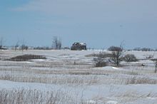
Cape Vincent is a village in Jefferson County, New York, United States. The population was 726 at the 2010 census. The village is in the west-central part of the town of Cape Vincent and is northwest of Watertown.
Clayton is a town in Jefferson County, New York, United States. The population was 5,153 at the 2010 census. The town is named after John M. Clayton, a federal political leader from Delaware.

Bedford is a town in Westchester County, New York, USA. The population was 17,335 at the 2010 census.
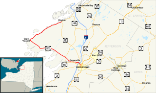
New York State Route 12E (NY 12E) is a state highway located entirely within the northwestern part of Jefferson County in northern New York in the United States. The southern terminus is at NY 12F in the village of Brownville. Its northern terminus, both signed and official, is at NY 12 in the village of Clayton. While NY 12 follows a direct north–south routing between Watertown and Clayton, NY 12E diverges westward to follow the shoreline of Lake Ontario. The portion of NY 12E north of its junction with NY 180 is part of the Seaway Trail, a National Scenic Byway.

The Craigflower Manor and Craigflower Schoolhouse are National Historic Sites of Canada located in View Royal, British Columbia and Saanich near Victoria. The centerpiece of each historic site is a 19th-century building — a manor and schoolhouse commissioned by the Hudson's Bay Company to provide education and lodging for their employees. Built as part of the agricultural community Craigflower Farm, the buildings served as a focal point for the community into the modern era; they remain open to the public today as museums devoted to the colonial history of Victoria.

Vincent LeRay House, also known as The Stone House, is a historic home located at Cape Vincent in Jefferson County, New York. It is located within the boundaries of the Broadway Historic District.

The Dry Mills Schoolhouse is a historic schoolhouse on Game Farm Road in Gray, Maine. Built about 1857, it is the town's last surviving single-room district schoolhouse, and is now a local museum. The building was added to the National Register of Historic Places listings on December 13, 1996.
Lamson Farm is a historic farm property on Lamson Road in Mont Vernon, New Hampshire. Founded in the 1770s and operated as a farm until 1975, it is one of the few surviving intact 19th-century farm properties in the community. Its land, over 300 acres (120 ha) in size, is now town-owned conservation and farmland. The property has trails open to the public, and an annual celebration of Lamson Farm Day is held here every September. The property was added to the National Register of Historic Places in 1981.