National Register of Historic Places listings in Wayne County, New York

Last updated

Location of Wayne County in New York Map of New York highlighting Wayne County.svg
Location of Wayne County in New York
Map all coordinates using: OpenStreetMap

List of the National Register of Historic Places listings in Wayne County, New York

Contents

This is intended to be a complete list of properties and districts listed on the National Register of Historic Places in Wayne County, New York. The locations of National Register properties and districts (at least for all showing latitude and longitude coordinates below) may be seen in a map by clicking on "Map of all coordinates". [1]


    This National Park Service list is complete through NPS recent listings posted October 20, 2023. [2]

Contents: Counties in New York
Albany (Albany)AlleganyBronxBroomeCattaraugusCayugaChautauquaChemungChenangoClintonColumbiaCortlandDelawareDutchess (Poughkeepsie, Rhinebeck)Erie (Buffalo)EssexFranklinFultonGeneseeGreeneHamiltonHerkimerJeffersonKingsLewisLivingstonMadisonMonroe (Rochester)MontgomeryNassauNew York (Below 14th Street, 14th to 59th Streets, 59th to 110th Streets, Above 110th Street, Islands)Niagara (Niagara Falls)OneidaOnondaga (Syracuse)OntarioOrangeOrleansOswegoOtsegoPutnamQueensRensselaerRichmondRocklandSt. LawrenceSaratogaSchenectadySchoharieSchuylerSenecaSteubenSuffolkSullivanTiogaTompkinsUlsterWarrenWashingtonWayneWestchester (Northern, Southern, New Rochelle, Peekskill, Yonkers)WyomingYates

Listings county-wide

[3] Name on the RegisterImageDate listed [4] Location City or townDescription
1 Alasa Farms
Alasa Farms 230 Alasa Farms barn on west side of road.JPG
Alasa Farms
October 16, 2009
(#09000835)
6450 Shaker Rd.
43°12′41″N76°58′48″W / 43.211278°N 76.980011°W / 43.211278; -76.980011 (Alasa Farms)
Alton
2 J. and E. Baker Cobblestone Farmstead
J. and E. Baker Cobblestone Farmstead J and E Baker Cobblestone Farmstead, Macedon, NY.JPG
J. and E. Baker Cobblestone Farmstead
November 7, 1995
(#95001281)
815 Canandaigua Rd.
43°02′04″N77°18′50″W / 43.034444°N 77.313889°W / 43.034444; -77.313889 (J. and E. Baker Cobblestone Farmstead)
Macedon
3 Brick Church Corners
Brick Church Corners North Ontario Methodist Church.JPG
Brick Church Corners
June 5, 1974
(#74001317)
Jct. of Brick Church and Ontario Center Rds.
43°15′27″N77°18′21″W / 43.2575°N 77.305833°W / 43.2575; -77.305833 (Brick Church Corners)
Ontario
4 Broad Street–Water Street Historic District
Broad Street-Water Street Historic District Broad and Water Street Historic District, Lyons, NY.JPG
Broad Street–Water Street Historic District
August 14, 1973
(#73001284)
Broad and Water Sts.
43°03′45″N76°59′43″W / 43.0625°N 76.995278°W / 43.0625; -76.995278 (Broad Street–Water Street Historic District)
Lyons
5 Charles Bullis House
Charles Bullis House Charles Bullis House, Macedon NY.JPG
Charles Bullis House
March 20, 1986
(#86000483)
1727 Canandaigua Rd.
43°04′10″N77°19′14″W / 43.069444°N 77.320556°W / 43.069444; -77.320556 (Charles Bullis House)
Macedon
6 Clyde Downtown Historic District
Clyde Downtown Historic District Clyde Downtown Historic District.jpg
Clyde Downtown Historic District
December 23, 2019
(#100004803)
Portions of Glasgow St., Caroline St., Columbia St., Sodus St., North & South Park, & West Genesee St.
43°05′03″N76°52′14″W / 43.0842°N 76.8705°W / 43.0842; -76.8705 (Clyde Downtown Historic District)
Clyde Core of village that developed around a local park from 1820 on, spurred by Erie Canal
7 Customs House May 6, 1980
(#80002787)
Sentell St.
43°16′01″N76°59′37″W / 43.266944°N 76.993611°W / 43.266944; -76.993611 (Customs House)
Sodus Point
8 Dipper Dredge No. 3
Dipper Dredge No. 3 Dipper Dredge 3, Lyons, NY.JPG
Dipper Dredge No. 3
December 11, 2007
(#07001257)
1665 Drydock Rd.
43°03′52″N77°01′10″W / 43.064444°N 77.019444°W / 43.064444; -77.019444 (Dipper Dredge No. 3)
Lyons
9 East Main Street Commercial Historic District
East Main Street Commercial Historic District East Main Street Commercial Historic District Palmyra NY Aug 09.jpg
East Main Street Commercial Historic District
November 21, 1974
(#74001318)
Between Clinton and William-Cuyler Sts.
43°03′49″N77°13′49″W / 43.063611°N 77.230278°W / 43.063611; -77.230278 (East Main Street Commercial Historic District)
Palmyra
10 East Palmyra Presbyterian Church
East Palmyra Presbyterian Church EastPalmyraPresbyterianChurch2020SouthwestSide.jpg
East Palmyra Presbyterian Church
December 31, 2002
(#02001651)
2102 Whitbeck Rd.
43°05′02″N77°08′52″W / 43.083889°N 77.147778°W / 43.083889; -77.147778 (East Palmyra Presbyterian Church)
East Palmyra
11 First Methodist Episcopal Church of Walworth
First Methodist Episcopal Church of Walworth FirstMethodistEpiscopalChurchOfWalworth2020.jpg
First Methodist Episcopal Church of Walworth
March 27, 2017
(#100000814)
3679 Main St.
43°08′17″N77°16′23″W / 43.138063°N 77.272926°W / 43.138063; -77.272926 (First Methodist Episcopal Church of Walworth)
Walworth Landmark in the community since its 1872 construction
12 First Presbyterian Church of Ontario Center
First Presbyterian Church of Ontario Center First Presbyterian Church of Ontario Center.JPG
First Presbyterian Church of Ontario Center
June 3, 1998
(#98000665)
1638 Ridge Rd.
43°13′31″N77°18′06″W / 43.225278°N 77.301667°W / 43.225278; -77.301667 (First Presbyterian Church of Ontario Center)
Ontario Center
13 Gates Hall and Pultneyville Public Square
Gates Hall and Pultneyville Public Square Gates Hall Sept 10.jpg
Gates Hall and Pultneyville Public Square
March 3, 2000
(#00000177)
Lake Rd.
43°16′48″N77°11′13″W / 43.28°N 77.186944°W / 43.28; -77.186944 (Gates Hall and Pultneyville Public Square)
Pultneyville
14 Grace Episcopal Church Complex
Grace Episcopal Church Complex Grace Episcopol, Lyons, NY.JPG
Grace Episcopal Church Complex
August 19, 1994
(#94000802)
7–9 Phelps St. and 12 Lawrence St.
43°03′55″N76°59′25″W / 43.065278°N 76.990278°W / 43.065278; -76.990278 (Grace Episcopal Church Complex)
Lyons
15 H. G. Hotchkiss Essential Oil Company Plant
H. G. Hotchkiss Essential Oil Company Plant H. G. HOTCHKISS ESSENTIAL OIL COMPANY PLANT, WAYNE COUNTY, NY.jpg
H. G. Hotchkiss Essential Oil Company Plant
November 2, 1987
(#87001897)
93-95 Water St.
43°03′46″N76°59′48″W / 43.062778°N 76.996667°W / 43.062778; -76.996667 (H. G. Hotchkiss Essential Oil Company Plant)
Lyons
16 Jackson–Perkins House
Jackson-Perkins House Jackson-Perkins House, Newark, NY.JPG
Jackson–Perkins House
July 14, 2006
(#06000567)
310 High St.
43°02′39″N77°05′58″W / 43.044167°N 77.099444°W / 43.044167; -77.099444 (Jackson–Perkins House)
Newark
17 Ambrose S. Lapham House
Ambrose S. Lapham House LaphamHousePalmyra2020c.jpg
Ambrose S. Lapham House
September 3, 2014
(#14000541)
352 W. Jackson St.
43°03′38″N77°14′36″W / 43.060544°N 77.2433057°W / 43.060544; -77.2433057 (Ambrose S. Lapham House)
Palmyra 1870 Italianate brick house built by local resident who returned after a successful banking career in Detroit
18 LOTUS (schooner)
LOTUS (schooner) Schooner Lotus at Mooring.JPG
LOTUS (schooner)
May 10, 1990
(#90000694)
Trestle Landing Marina, Co. Rt. 14 at Sentell Rd.
43°15′59″N76°59′29″W / 43.266389°N 76.991389°W / 43.266389; -76.991389 (LOTUS (schooner))
Sodus Point
19 Lyons Downtown Historic District
Lyons Downtown Historic District Wayne County Courthouse, Lyons, NY.jpg
Lyons Downtown Historic District
March 12, 2018
(#SG100002190)
Broad bounded by Phelps, William, Butternut, Pearl & Canal with portions of Bear, Lawrence, Geneva & Water Sts.
43°03′48″N76°59′36″W / 43.0634°N 76.9934°W / 43.0634; -76.9934 (Lyons Downtown Historic District)
Lyons Core of county seat, reflecting 18th century origins, 19th-century growth as canal town and 20th-century industrialization
20 Market Street Historic District
Market Street Historic District Market Street Historic District, Palymyra NY.JPG
Market Street Historic District
December 8, 1972
(#72000916)
Both sides of Market St. between Canal and Main Sts.
43°03′52″N77°13′47″W / 43.064444°N 77.229722°W / 43.064444; -77.229722 (Market Street Historic District)
Palmyra
21 Methodist Episcopal Church of Butler
Methodist Episcopal Church of Butler MethodistEpiscopalChurchOfButler2020FromSouthwest.jpg
Methodist Episcopal Church of Butler
November 24, 1997
(#97001459)
Butler Center Rd., jct. with Washburn Rd.
43°10′06″N76°46′17″W / 43.168333°N 76.771389°W / 43.168333; -76.771389 (Methodist Episcopal Church of Butler)
Butler Center
22 New York State Barge Canal
New York State Barge Canal FTCCanalLock27.jpg
New York State Barge Canal
October 15, 2014
(#14000860)
Linear across county
43°03′55″N77°14′47″W / 43.065224°N 77.246491°W / 43.065224; -77.246491 (New York State Barge Canal)
Arcadia, Clyde, Galen, Lyons, Newark, Palmyra, SavannahSuccessor to Erie Canal approved by state voters in early 20th century to compete with railroads.
23 Palmyra Village Historic District
Palmyra Village Historic District Palmyra Village Hall Aug 09.jpg
Palmyra Village Historic District
October 16, 2009
(#09000836)
Portions of Canandaigua, Church, Cuyler, E. and W. Jackson, Market, E. and W. Main Sts.
43°03′50″N77°14′00″W / 43.063953°N 77.233314°W / 43.063953; -77.233314 (Palmyra Village Historic District)
Palmyra
24 Ezra T. Phelps Farm Complex
Ezra T. Phelps Farm Complex Ezra T Phelps Farm Complex, Marion NY.JPG
Ezra T. Phelps Farm Complex
August 13, 1997
(#97000843)
4365 E. Williamson Rd.
43°09′13″N77°09′51″W / 43.153611°N 77.164167°W / 43.153611; -77.164167 (Ezra T. Phelps Farm Complex)
Marion
25 Preston-Gaylord Cobblestone Farmhouse
Preston-Gaylord Cobblestone Farmhouse PRESTON-GAYLORD COBBLESTONE FARMHOUSE, WAYNE COUNTY, NY.jpg
Preston-Gaylord Cobblestone Farmhouse
December 11, 2009
(#09001088)
7563 Lake Rd.
43°15′57″N77°01′28″W / 43.265967°N 77.024478°W / 43.265967; -77.024478 (Preston-Gaylord Cobblestone Farmhouse)
Sodus
26 Pultneyville Historic District
Pultneyville Historic District House on Lake Rd Pultneyville NY Sept 10.jpg
Pultneyville Historic District
September 11, 1985
(#85002325)
Sections of Lake Rd. and Jay St.
43°16′48″N77°10′54″W / 43.28°N 77.181667°W / 43.28; -77.181667 (Pultneyville Historic District)
Pultneyville
27 Red Brick Church
Red Brick Church RED BRICK CHURCH (SODUS CENTER) WAYNE COUNTY.jpg
Red Brick Church
December 8, 1997
(#97001527)
Jct. of Brick Church Rd. and S. Geneva Rd.
43°11′58″N77°00′42″W / 43.199444°N 77.011667°W / 43.199444; -77.011667 (Red Brick Church)
Sodus Center
28 Roe Cobblestone Schoolhouse
Roe Cobblestone Schoolhouse RoeCobblestoneSchoolhouse2020NorthwestView.jpg
Roe Cobblestone Schoolhouse
September 17, 2008
(#08000920)
12397 Van Vleck Rd.
43°11′25″N76°47′00″W / 43.190389°N 76.783453°W / 43.190389; -76.783453 (Roe Cobblestone Schoolhouse)
Butler
29 Smith-Ely Mansion
Smith-Ely Mansion Smith-Ely Mansion Oct 09.jpg
Smith-Ely Mansion
February 10, 1992
(#92000032)
39 W. Genesee St.
43°05′07″N76°52′25″W / 43.085278°N 76.873611°W / 43.085278; -76.873611 (Smith-Ely Mansion)
Clyde
30 Sodus Point Lighthouse
Sodus Point Lighthouse Soduspoint.JPG
Sodus Point Lighthouse
October 8, 1976
(#76001288)
Off NY 14 at Lake Ontario
43°16′25″N76°59′12″W / 43.273611°N 76.986667°W / 43.273611; -76.986667 (Sodus Point Lighthouse)
Sodus Point
31 St. Peter, (Shipwreck)
St. Peter, (Shipwreck) Lake Ontario at Pultneyville NY Sept 10.jpg
St. Peter, (Shipwreck)
March 22, 2004
(#04000226)
Address Restricted
43°18′42″N77°07′52″W / 43.311667°N 77.131111°W / 43.311667; -77.131111 (St. Peter, (Shipwreck))
Pultneyville
32 Isaac Shipley House
Isaac Shipley House Isaac E Shipley House.jpg
Isaac Shipley House
November 15, 2022
(#100008383)
7470 Lake Ave.
43°16′06″N77°11′04″W / 43.2683°N 77.1844°W / 43.2683; -77.1844 (Isaac Shipley House)
Williamson vicinity
33 Towar–Ennis Farmhouse and Barn Complex
Towar-Ennis Farmhouse and Barn Complex TOWAR-ENNIS FARMHOUSE AND BARN COMPLEX, WAYNE COUNTY.jpg
Towar–Ennis Farmhouse and Barn Complex
October 16, 2009
(#09000967)
265 NY-14
43°01′12″N76°59′12″W / 43.019922°N 76.986703°W / 43.019922; -76.986703 (Towar–Ennis Farmhouse and Barn Complex)
Lyons
34 US Post Office-Clyde
US Post Office-Clyde U.S. Post Office Clyde NY Jul 08.jpg
US Post Office-Clyde
November 17, 1988
(#88002472)
26 S. Park St.
43°05′01″N76°52′16″W / 43.083611°N 76.871111°W / 43.083611; -76.871111 (US Post Office-Clyde)
Clyde
35 US Post Office-Lyons
US Post Office-Lyons Lyons USPO, Lyons NY.JPG
US Post Office-Lyons
May 11, 1989
(#88002349)
1-5 Pearl St.
43°03′46″N76°59′37″W / 43.062778°N 76.993611°W / 43.062778; -76.993611 (US Post Office-Lyons)
Lyons
36 US Post Office-Newark
US Post Office-Newark U.S. Post Office Newark NY Aug 09.jpg
US Post Office-Newark
May 11, 1989
(#88002366)
300 S. Main St. [5]
43°02′37″N77°05′43″W / 43.043611°N 77.095278°W / 43.043611; -77.095278 (US Post Office-Newark)
Newark
37 Walling Cobblestone Tavern
Walling Cobblestone Tavern Walling Cobblestone Tavern.JPG
Walling Cobblestone Tavern
March 17, 1994
(#94000173)
7851 Ridge Rd., Hamlet of Wallington
43°13′18″N77°00′44″W / 43.221667°N 77.012222°W / 43.221667; -77.012222 (Walling Cobblestone Tavern)
Sodus
38 Wallington Cobblestone Schoolhouse District No. 8
Wallington Cobblestone Schoolhouse District No. 8 Wallington Cobblestone Schoolhouse District No. 8 212.JPG
Wallington Cobblestone Schoolhouse District No. 8
March 17, 1994
(#94000172)
6135 N. Geneva Rd., Hamlet of Wallington
43°13′23″N77°00′48″W / 43.223056°N 77.013333°W / 43.223056; -77.013333 (Wallington Cobblestone Schoolhouse District No. 8)
Sodus
39 Wolcott Square Historic District
Wolcott Square Historic District Venus Fountain and Village Hall Wolcott NY Oct 09.jpg
Wolcott Square Historic District
May 17, 2001
(#00001692)
W. Main, Park, and New Hartford Sts.
43°13′12″N76°48′58″W / 43.22°N 76.816111°W / 43.22; -76.816111 (Wolcott Square Historic District)
Wolcott
40 Zion Episcopal Church
Zion Episcopal Church Zion Episcopal Church Palmyra NY Aug 09.jpg
Zion Episcopal Church
November 29, 1996
(#96001388)
100-120 Main St.
43°03′47″N77°14′00″W / 43.063056°N 77.233333°W / 43.063056; -77.233333 (Zion Episcopal Church)
Palmyra

See also

Related Research Articles

<span class="mw-page-title-main">National Register of Historic Places listings in Fulton County, New York</span>

List of the National Register of Historic Places listings in Fulton County, New York

<span class="mw-page-title-main">National Register of Historic Places listings in Genesee County, New York</span>

List of the National Register of Historic Places listings in Genesee County, New York

<span class="mw-page-title-main">National Register of Historic Places listings in Jefferson County, New York</span>

List of the National Register of Historic Places listings in Jefferson County, New York

<span class="mw-page-title-main">National Register of Historic Places listings in Lewis County, New York</span>

List of the National Register of Historic Places listings in Lewis County, New York

<span class="mw-page-title-main">National Register of Historic Places listings in Livingston County, New York</span>

List of the National Register of Historic Places listings in Livingston County, New York

<span class="mw-page-title-main">National Register of Historic Places listings in Niagara County, New York</span>

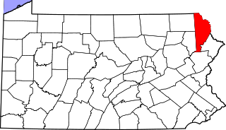
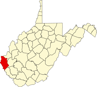
This is a list of the National Register of Historic Places listings in Erie County, New York.

<span class="mw-page-title-main">National Register of Historic Places listings in Oneida County, New York</span>

List of the National Register of Historic Places listings in Oneida County, New York

<span class="mw-page-title-main">National Register of Historic Places listings in Ontario County, New York</span>

List of the National Register of Historic Places listings in Ontario County, New York

<span class="mw-page-title-main">National Register of Historic Places listings in Oswego County, New York</span>

List of the National Register of Historic Places listings in Oswego County, New York

<span class="mw-page-title-main">National Register of Historic Places listings in Putnam County, New York</span>

List of the National Register of Historic Places listings in Putnam County, New York

<span class="mw-page-title-main">National Register of Historic Places listings in Saratoga County, New York</span>

List of the National Register of Historic Places listings in Saratoga County, New York

<span class="mw-page-title-main">National Register of Historic Places listings in Seneca County, New York</span>

List of Registered Historic Places in Seneca County, New York

<span class="mw-page-title-main">National Register of Historic Places listings in Steuben County, New York</span>

List of the National Register of Historic Places listings in Steuben County, New York

<span class="mw-page-title-main">National Register of Historic Places listings in Yates County, New York</span>

List of the National Register of Historic Places listings in Yates County, New York

<span class="mw-page-title-main">National Register of Historic Places listings in Washington County, New York</span>

List of the National Register of Historic Places listings in Washington County, New York

<span class="mw-page-title-main">National Register of Historic Places listings in Tompkins County, New York</span>

List of the National Register of Historic Places listings in Tompkins County, New York

<span class="mw-page-title-main">National Register of Historic Places listings in Tioga County, New York</span>

List of the National Register of Historic Places listings in Tioga County, New York

<span class="mw-page-title-main">National Register of Historic Places listings in Madison County, New York</span>

List of the National Register of Historic Places listings in Madison County, New York

This is intended to be a complete list of properties and districts listed on the National Register of Historic Places on Manhattan Island below 14th Street, which is a significant portion of the New York City borough of Manhattan. In turn, the borough of Manhattan is coterminous with New York County, New York. For properties and districts in other parts of Manhattan Island, the mainland neighborhood of Marble Hill, and the other islands of New York County, see National Register of Historic Places listings in Manhattan. The locations of National Register properties and districts may be seen in an online map by clicking on "Map of all coordinates".

This is intended to be a complete list of historic properties and districts listed on the National Register of Historic Places located on islands other than Manhattan Island but still in New York County, New York. For all properties and districts in the borough of Manhattan, see National Register of Historic Places listings in New York County, New York. The locations of National Register properties and districts may be seen in an online map by clicking on "Map of all coordinates".

References

  1. The latitude and longitude information provided in this table was derived originally from the National Register Information System, which has been found to be fairly accurate for about 99% of listings. Some locations in this table may have been corrected to current GPS standards.
  2. National Park Service, United States Department of the Interior, "National Register of Historic Places: Weekly List Actions", retrieved October 20, 2023.
  3. Numbers represent an alphabetical ordering by significant words. Various colorings, defined here, differentiate National Historic Landmarks and historic districts from other NRHP buildings, structures, sites or objects.
  4. The eight-digit number below each date is the number assigned to each location in the National Register Information System database, which can be viewed by clicking the number.
  5. Address based on USPS website. Accessed April 2, 2016.