Listings above 110th Street
| [3] | Name on the Register | Image | Date listed [4] | Location | City or town | Description |
|---|---|---|---|---|---|---|
| 1 | 32nd Police Precinct Station House Complex |  | August 8, 2019 (#100004243) | 1850–1854 Amsterdam Avenue 40°49′47″N73°56′41″W / 40.8296°N 73.9448°W | Harlem | 1870s Second Empire police station complex, now offices for community groups, reflects changing role of police at time of construction; was in use for almost a century |
| 2 | 116th Street-Columbia University Subway Station (IRT) |  | September 17, 2004 (#04001020) | Junction of Broadway and West 116th St. 40°48′28″N73°57′52″W / 40.807778°N 73.964444°W | Morningside Heights | Subway station ( 1 train) |
| 3 | 145th Street Subway Station (IRT) |  | March 30, 2005 (#05000231) | Under Lenox Avenue at the jct. with 145th St. 40°49′13″N73°56′12″W / 40.820278°N 73.936667°W | Harlem | Subway station ( 3 train) |
| 4 | 168th Street Subway Station (IRT) |  | March 30, 2005 (#05000232) | Under Broadway at the jct. of W. 168th St. 40°50′26″N73°56′26″W / 40.840556°N 73.940556°W | Washington Heights | Subway station ( 1 train). Lower set of tracks (1 train) is only station along Fort George Tunnel where its semicircular vaulted ceiling is visible. |
| 5 | 181st Street Subway Station (IND) |  | March 30, 2005 (#05000233) | Fort Washington Ave., Vet. W. 185th and 181st Sts. 40°51′06″N73°56′18″W / 40.851667°N 73.938333°W | Washington Heights | Subway station ( A train) |
| 6 | 181st Street Subway Station (IRT) | 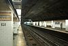 | March 30, 2005 (#05000224) | Under St. Nicholas Ave. bet. W. 181st and W. 180th St.s 40°50′58″N73°56′03″W / 40.849444°N 73.934167°W | Washington Heights | Subway station ( 1 train) |
| 7 | 190th Street Subway Station (IND) |  | March 30, 2005 (#05000225) | Under Fort Washington Ave. bet. Fort Tryon Park (Cabrini Blvd.) and W. 190th St/ 40°51′32″N73°56′05″W / 40.858889°N 73.934722°W | Washington Heights | Subway station ( A train) |
| 8 | 207th Street Yard – Signal Service Building and Tower B |  | February 9, 2006 (#06000018) | W. 215th St. bet. Tenth Ave. and the Harlem R 40°52′06″N73°54′49″W / 40.868333°N 73.913611°W | Inwood | |
| 9 | 369th Regiment Armory |  | January 28, 1994 (#93001537) | 2366 Fifth Ave. 40°49′03″N73°56′04″W / 40.8174°N 73.934337°W | Harlem | Home of the 369th Regiment, Harlem Hellfighters |
| 10 | Ansche Chesed Synagogue |  | June 9, 2014 (#14000289) | 1883 Adam Clayton Powell Jr. Blvd. 40°48′07″N73°57′11″W / 40.8019°N 73.9530°W | Harlem | Congregation founded in late 1820s was the largest synagogue in the country by mid-19th century. Now Mount Neboh Baptist Church. |
| 11 | Apollo Theater |  | November 17, 1983 (#83004059) | 253 W. 125th St. 40°48′36″N73°57′01″W / 40.81°N 73.950278°W | Harlem | Venue for African-American mid-20th century popular musicians |
| 12 | Audubon Park Historic District | August 9, 2024 (#100010615) | Generally, Broadway, Riverside Drive, Riverside Drive West, West 155th, 156th, 157th, and West 158th Street, and Edward M. Morgan Place 40°50′06″N73°56′49″W / 40.8349°N 73.9470°W | Washington Heights | ||
| 13 | Audubon Terrace Historic District |  | May 30, 1980 (#80002667) | Bounded by Broadway, W. 155th and W. 156th Sts. 40°50′00″N73°56′49″W / 40.833333°N 73.946944°W | Washington Heights | |
| 14 | John James Audubon Houses | July 5, 2022 (#100007881) | 1909 Amsterdam Ave. 40°49′52″N73°56′35″W / 40.8312°N 73.9430°W | |||
| 15 | James Bailey House |  | April 23, 1980 (#80002668) | 10 St. Nicholas Pl. (at 150th St.) 40°49′38″N73°56′33″W / 40.827222°N 73.9425°W | Harlem | (Ed. note: see NYTimes article) |
| 16 | Mary McLeod Bethune Gardens | February 14, 2022 (#100007411) | 1945 Amsterdam Ave. 40°49′57″N73°56′32″W / 40.8324°N 73.9422°W | |||
| 17 | Broadway Synagogue, Old |  | January 11, 2002 (#01001440) | 15 Old Broadway (nr 125th St & Bway) 40°48′55″N73°57′27″W / 40.815278°N 73.9575°W | Harlem | |
| 18 | Brooks and Hewitt Halls | 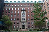 | November 15, 2003 (#03001151) | Jct. W. 116th St. and Claremont Ave. 40°48′30″N73°57′54″W / 40.808333°N 73.965°W | Morningside Heights | |
| 19 | Calvary Methodist Episcopal Church |  | May 16, 2016 (#16000255) | 211 W. 129th St., 2190 Adam Clayton Powell, Jr. Blvd. 40°48′43″N73°56′48″W / 40.81191°N 73.94679°W | Harlem | Elaborate Romanesque John Rochester Thomas church was largest in city upon 1887 construction; later expanded and sold to black congregation which renamed it Salem United Methodist Church. |
| 20 | Casa Italiana |  | October 29, 1982 (#82001188) | 1151–1161 Amsterdam Ave. (@ 116th) 40°48′26″N73°57′39″W / 40.807222°N 73.960833°W | Morningside Heights | |
| 21 | Central Harlem North Historic District | February 20, 2024 (#100009934) | Generally West 135th Street-West 144th Street, Adam Clayton Powell Jr. Boulevard, Lenox Avenue 40°48′57″N73°56′36″W / 40.8159°N 73.9432°W | Harlem | ||
| 22 | Chapel of the Intercession Complex and Trinity Cemetery |  | July 24, 1980 (#80002677) | 550 W. 155th St. 40°49′56″N73°56′50″W / 40.832222°N 73.947222°W | Washington Heights | |
| 23 | Church of Notre Dame and Rectory |  | May 6, 1980 (#80002678) | 405 W. 114th St. and 40 Morningside Dr. 40°48′18″N73°57′38″W / 40.805°N 73.960556°W | Morningside Heights | |
| 24 | College of the City of New York |  | September 7, 1984 (#84002763) | Bounded by Amsterdam Ave., St. Nicholas Terr., W. 138th, and W. 140th Sts. 40°49′15″N73°56′58″W / 40.820833°N 73.949444°W | Upper Manhattan | |
| 25 | Congregation Shaare Zedek of Harlem |  | February 23, 2015 (#15000031) | 23 W. 118th St. 40°48′10″N73°56′48″W / 40.8027°N 73.9468°W | Harlem | 1901 Moorish Revival synagogue built for one of city's oldest Jewish congregations has primarily been a Protestant church since 1930s serving local African-American community. |
| 26 | Will Marion Cook House |  | May 11, 1976 (#76001238) | 221 W. 138th St. 40°49′04″N73°56′37″W / 40.817778°N 73.943611°W | Harlem | Musician Will Marion Cook lived here |
| 27 | Croton Aqueduct Gate House |  | September 22, 1983 (#83001721) | 135th St. and Convent Ave. 40°49′06″N73°57′06″W / 40.818333°N 73.951667°W | Upper Manhattan | |
| 28 | Delta Psi, Alpha Chapter |  | April 26, 1996 (#96000484) | 434 Riverside Dr. (@ 115th) 40°48′30″N73°57′59″W / 40.808333°N 73.966389°W | Morningside Heights | |
| 29 | Dorrance Brooks Square Historic District |  | August 8, 2019 (#100004239) | Edgecombe Avenue, West 136th–140th Streets 40°49′08″N73°56′45″W / 40.8188°N 73.9459°W | Harlem | Neighborhood that takes its name from black serviceman killed during World War I was closely associated with many Harlem Renaissance figures; also contains many of the rowhouses that characterized Harlem's early development |
| 30 | Dunbar Apartments |  | March 29, 1979 (#79001601) | Bounded by 7th and 8th Aves. and W. 149th and 150th Sts. 40°49′30″N73°56′20″W / 40.825°N 73.938889°W | Harlem | |
| 31 | Dyckman Street Subway Station (IRT) |  | September 17, 2004 (#04001021) | Bet. Hillside and St. Nicholas Aves., jct. of Dyckman St. and Nagle Ave. 40°51′39″N73°55′34″W / 40.860833°N 73.926111°W | Inwood | Subway station ( 1 train) |
| 32 | William Dyckman House |  | December 24, 1967 (#67000014) | 4881 Broadway 40°52′03″N73°55′24″W / 40.8675°N 73.923333°W | Inwood | Last remaining farmhouse in Manhattan, dating to late 18th century. Now a museum run by the Parks Department. |
| 33 | Earl Hall |  | March 12, 2018 (#100002189) | 2980 Broadway 40°48′31″N73°57′46″W / 40.8086°N 73.96268°W | Morningside Heights | 1902 McKim, Mead and White building was one of first on Columbia's Morningside Heights campus; later housed offices of Student Homophile League, first U.S. student LGBT organization |
| 34 | East Harlem Historic District |  | July 10, 2019 (#100004218) | Generally E. 111th–120th Sts., Park, Lexington, Pleasant, 1st–3rd Aves. 40°47′54″N73°56′19″W / 40.7982°N 73.9385°W | East Harlem | Neighborhood mostly developed between Civil War and World War I, reflecting occupancy by several different ethnic groups |
| 35 | Edward Kennedy "Duke" Ellington House |  | May 11, 1976 (#76001239) | 935 St. Nicholas Ave., Apt. 4A 40°49′56″N73°56′29″W / 40.832147°N 73.9413°W | Harlem | Home of jazz legend Duke Ellington for much of his adult life |
| 36 | Elmendorf Reformed Church | 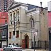 | April 27, 2010 (#10000225) | 171 E. 121st St. 40°48′05″N73°56′18″W / 40.801439°N 73.938347°W | Harlem | |
| 37 | Fire Hook and Ladder Company No. 14 |  | May 22, 2013 (#13000309) | 120 E. 125th St. 40°48′16″N73°56′17″W / 40.804444°N 73.938139°W | Harlem | currently accommodates the Caribbean Cultural Center African Diaspora Institute |
| 38 | First African Methodist Episcopal Church, Bethel |  | November 9, 2018 (#100003116) | 60 W. 132nd St. 40°48′41″N73°56′28″W / 40.8115°N 73.9411°W | Harlem | Neo-Gothic church houses one of Harlem's most important black churches, key to neighborhood development throughout 20th century; Marcus Garvey gave his first Harlem speech here. |
| 39 | Fort Tryon Park and the Cloisters | 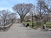 | December 19, 1978 (#78001870) | Broadway and Dyckman St. 40°51′39″N73°55′57″W / 40.860833°N 73.9325°W | Hudson Heights within Washington Heights | |
| 40 | Fort Washington Avenue Armory |  | March 2, 1995 (#95000085) | 216 Fort Washington Ave. (jct. with 168th St.) 40°50′31″N73°56′31″W / 40.841944°N 73.941944°W | Washington Heights | 1911 neoclassical armory was one of first in city in that style. Now home to National Track and Field Hall of Fame. |
| 41 | Fort Washington Presbyterian Church |  | January 7, 2010 (#09001209) | 21 Wadsworth Ave. 40°50′43″N73°56′16″W / 40.845278°N 73.937778°W | Washington Heights | |
| 42 | The Fourth Church of Christ, Scientist |  | August 31, 2011 (#11000620) | 551 Ft. Washington Ave. 40°51′13″N73°56′16″W / 40.853611°N 73.937778°W | Washington Heights | |
| 43 | Fort Washington Site |  | December 6, 1978 (#78001871) | Bennett Park, Ft. Washington Ave. at 183rd St. "Address Restricted" | Washington Heights | |
| 44 | General Grant National Memorial |  | October 15, 1966 (#66000055) | Riverside Dr. and W. 122nd St. 40°48′48″N73°57′49″W / 40.813333°N 73.963611°W | Morningside Heights | |
| 45 | Hamilton Grange National Memorial |  | October 15, 1966 (#66000097) | 414 W. 141st Street 40°49′17″N73°56′50″W / 40.8214°N 73.9473°W | Hamilton Heights | Home of Alexander Hamilton; relocated to St. Nicholas Park in 2008 |
| 46 | Hamilton Heights Historic District |  | September 30, 1983 (#83001727) | Roughly bounded by St. Nicholas and Amsterdam Aves, W. 145 and W. 140th Sts. 40°49′21″N73°56′54″W / 40.8225°N 73.9483°W | Hamilton Heights | |
| 47 | Harlem African Burial Ground |  | January 29, 2018 (#100002055) | 2460 2nd Ave. 40°48′10″N73°55′52″W / 40.8028°N 73.9312°W | Harlem | Burial ground of enslaved Africans from 1660s to 1858 rediscovered by 21st-century archaeologists; currently under 126th Street bus garage but will be preserved in redevelopment |
| 48 | Harlem Courthouse |  | April 16, 1980 (#80002692) | 170 E. 121st St. 40°48′04″N73°56′21″W / 40.8011°N 73.9392°W | Harlem | |
| 49 | Harlem Fire Watchtower |  | June 21, 1976 (#76001240) | Marcus Garvey Park at E. 122nd St. 40°48′14″N73°56′38″W / 40.8039°N 73.9439°W | Harlem | Only survivor of 11 fire watchtowers once covering Manhattan and/or the city |
| 50 | Harlem River Houses |  | December 18, 1979 (#79001605) | 151st to 153rd St., Macombs Pl. and Harlem River Dr. 40°49′33″N73°56′12″W / 40.8258°N 73.9367°W | Harlem | |
| 51 | Harlem Savings Bank |  | August 28, 2003 (#03000849) | 124 E. 125th St. 40°48′13″N73°56′20″W / 40.8036°N 73.9389°W | Harlem | |
| 52 | Matthew Henson Residence |  | May 15, 1975 (#75001207) | 246 W. 150th St., Apt. 3F 40°49′32″N73°56′19″W / 40.8256°N 73.9386°W | Harlem | |
| 53 | High Bridge Aqueduct and Water Tower |  | December 4, 1972 (#72001560) | Harlem River at W. 170th St. and High Bridge Park 40°50′34″N73°55′57″W / 40.8427°N 73.9325°W | Washington Heights | |
| 54 | Hispanic Society of America Complex |  | October 16, 2012 (#12001009) | 613 W. 155th St. 40°50′01″N73°56′47″W / 40.8336°N 73.9465°W | Washington Heights | |
| 55 | Holy Cross African Orthodox Pro-Cathedral |  | November 9, 2017 (#100001803) | 122 W. 129th St. 40°48′38″N73°56′41″W / 40.8106°N 73.9447°W | Harlem | First and only African Orthodox Church cathedral |
| 56 | Holyrood Protestant Episcopal Church |  | October 29, 2020 (#100005702) | 715 West 179th St. 40°50′58″N73°56′20″W / 40.8495°N 73.9389°W | Washington Heights | |
| 57 | Hotel Theresa |  | June 16, 2005 (#05000618) | 2082–2096 Adam Clayton Powell, Jr. Blvd. 40°48′31″N73°56′58″W / 40.8086°N 73.9494°W | Harlem | |
| 58 | Hudson View Gardens |  | February 16, 2016 (#16000020) | 116 Pinehurst Ave. 40°51′12″N73°56′20″W / 40.8533°N 73.9388°W | Hudson Heights | Largest housing cooperative in the U.S. when built in early 1920s |
| 59 | Langston Hughes House |  | October 29, 1982 (#82001198) | 20 E. 127th St. 40°48′26″N73°56′27″W / 40.8072°N 73.9408°W | Harlem | Home of Langston Hughes, important African-American poet |
| 60 | International House |  | September 10, 1999 (#99001129) | 500 Riverside Dr. 40°48′49″N73°57′43″W / 40.8136°N 73.9619°W | Morningside Heights | |
| 61 | IRT Broadway Line Viaduct | 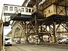 | September 15, 1983 (#83001749) | W. 122nd St. to W. 135th St., Broadway 40°49′12″N73°57′20″W / 40.82°N 73.9556°W | Harlem | Viaduct station on the 1 train. |
| 62 | Ivey Delph Apartments |  | January 20, 2005 (#04001531) | 17–19 Hamilton Terrace (at 141st St.) 40°49′20″N73°56′50″W / 40.8222°N 73.9472°W | Hamilton Heights | |
| 63 | Jeffrey's Hook Lighthouse |  | May 29, 1979 (#79003130) | Fort Washington Park 40°51′00″N73°56′52″W / 40.85°N 73.9478°W | Washington Heights | Famous as Little Red Lighthouse underneath the giant G W bridge |
| 64 | James Weldon Johnson House |  | May 11, 1976 (#76001241) | 187 W. 135th St. 40°48′54″N73°56′36″W / 40.8151°N 73.9432°W | Harlem | Home of James Weldon Johnson |
| 65 | Jumel Terrace Historic District |  | April 3, 1973 (#73001220) | W. 160th and 162nd Sts. between St. Nicholas and Edgecombe Aves. 40°50′05″N73°56′21″W / 40.8347°N 73.9392°W | Washington Heights | |
| 66 | Low Memorial Library, Columbia University | 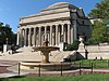 | December 23, 1987 (#87002599) | W. 116th St. between Broadway and Amsterdam Ave. 40°48′29″N73°57′45″W / 40.808056°N 73.9625°W | Morningside Heights | Largest granite domed building in U.S. Now used as Columbia's main administration building |
| 67 | Manhattan Avenue-West 120th–123rd Streets Historic District |  | January 17, 1992 (#91001920) | 242–262 W. 120th St., 341–362 W. 121st St., 341–362 W. 122nd St., 344–373 123rd St., 481–553 Manhattan Ave. W side 40°48′32″N73°57′19″W / 40.808889°N 73.955278°W | Harlem | |
| 68 | Manhattanville Houses |  | June 17, 2024 (#100010432) | 3224-3250 Broadway, 545-555 West 126th Street. 1414-1470 Amsterdam Avenue, 556-578 West 131th Street. 500-520 West 133th Street 40°48′58″N73°57′26″W / 40.8162°N 73.9571°W | Harlem | |
| 69 | Claude McKay Residence |  | December 8, 1976 (#76002143) | 180 W. 135th St. 40°48′54″N73°56′34″W / 40.814864°N 73.942881°W | Harlem | Also known as Harlem YMCA |
| 70 | Milbank, Brinckerhoff, and Fiske Halls |  | November 15, 2003 (#03001152) | Roughly bounded by W. 119th and W. 120th Sts., and Broadway and Claremont Aves. 40°48′38″N73°57′48″W / 40.810556°N 73.963333°W | Morningside Heights | |
| 71 | Minton's Playhouse |  | September 18, 1985 (#85002423) | 206–210 W. 118th St. 40°48′17″N73°57′12″W / 40.804722°N 73.953333°W | Harlem | |
| 72 | Morris-Jumel Mansion | 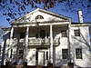 | October 15, 1966 (#66000545) | 160th St. and Edgecombe Ave. 40°50′04″N73°56′19″W / 40.834444°N 73.938611°W | Washington Heights | |
| 73 | Mount Morris Bank |  | December 7, 1989 (#89002087) | E. 125th St. and Park Ave. 40°48′19″N73°56′22″W / 40.805278°N 73.939444°W | Harlem | |
| 74 | Mount Morris Park Historic District |  | February 6, 1973 (#73001221) | Bounded roughly by Lenox Ave., Mount Morris Park West, and W. 124th and W. 119th Sts. 40°48′17″N73°56′49″W / 40.804722°N 73.946944°W | Harlem | |
| 75 | New York Amsterdam News Building |  | May 11, 1976 (#76001247) | 2293 7th Ave. 40°48′54″N73°56′41″W / 40.815°N 73.944722°W | Harlem | Once offices of major early 20th-century African-American newspaper, New York Amsterdam News . |
| 76 | New York Presbyterian Church | 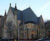 | June 3, 1982 (#82003385) | 151 W. 128th St & 7th Ave. 40°48′39″N73°56′49″W / 40.810833°N 73.946944°W | Harlem | Sign on church says it is Baptist |
| 77 | National Headquarters, March on Washington for Jobs and Freedom |  | February 3, 2020 (#100004933) | 170 W. 130th St. 40°48′42″N73°56′44″W / 40.8117°N 73.9456°W | Harlem | Townhouse where 1963 civil rights march where Martin Luther King Jr. gave his "I Have a Dream" speech was organized and planned |
| 78 | New York Public Library, 115th Street Branch |  | May 6, 1980 (#80002704) | 203 W. 115th St. 40°48′10″N73°57′14″W / 40.802778°N 73.953889°W | Harlem | |
| 79 | New York Public Library, Fort Washington Branch |  | August 27, 2020 (#100005470) | 535 West 179th St. 40°50′52″N73°56′02″W / 40.847781°N 73.933943°W | Washington Heights | |
| 80 | New York Public Library, Hamilton Grange Branch |  | July 23, 1981 (#81000410) | 503 and 505 W. 145th St. 40°49′32″N73°56′54″W / 40.825556°N 73.948333°W | Washington Heights | |
| 81 | North Presbyterian Church |  | February 5, 2014 (#13001153) | 525 W. 155th St. 40°49′57″N73°56′39″W / 40.8324°N 73.9442°W | Washington Heights | |
| 82 | Park and Tilford Building |  | May 1, 2009 (#09000258) | 310 Lenox Ave. 40°48′29″N73°56′41″W / 40.808119°N 73.944764°W | Harlem | |
| 83 | Philosophy Hall |  | July 31, 2003 (#03001046) | 1150 Amsterdam Avenue 40°48′26″N73°57′41″W / 40.807222°N 73.961389°W | Morningside Heights | Edwin Howard Armstrong invented FM radio in a basement lab |
| 84 | Public School 157 |  | December 10, 1982 (#82003387) | 327 St. Nicholas Ave. 40°48′42″N73°57′09″W / 40.811667°N 73.9525°W | Harlem | |
| 85 | Pupin Physics Laboratories, Columbia University |  | October 15, 1966 (#66000550) | Broadway and 120th St. 40°48′36″N73°57′42″W / 40.81°N 73.961667°W | Morningside Heights | First successful atom splitting on U.S. soil performed in basement lab |
| 86 | Riverside Church |  | December 12, 2012 (#12001036) | 478, 490 Riverside Dr. & 81 Claremont Ave. 40°48′43″N73°57′48″W / 40.811966°N 73.963321°W | Morningside Heights | John D. Rockefeller and Harry Emerson Fosdick established this interdenominational church in 1930, known for its role in social and political activism. Its 392-foot (119 m) tower makes it the tallest church in the U.S. |
| 87 | Riverside Park and Drive |  | September 2, 1983 (#83001743) | From 72nd St. to 129th St. 40°47′53″N73°58′31″W / 40.798056°N 73.975278°W | Upper West Side to Inwood | First major Robert Moses project in Manhattan sped travel to Bronx and made riverfront accessible as park |
| 88 | Paul Robeson Home |  | December 8, 1976 (#76001248) | 555 Edgecombe Ave. 40°50′04″N73°56′20″W / 40.834444°N 73.938889°W | Washington Heights | |
| 89 | St. Andrew's Episcopal Church | 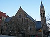 | March 18, 1980 (#80002717) | 2067 5th Ave. 40°48′28″N73°56′33″W / 40.807778°N 73.9425°W | Harlem | |
| 90 | St. Luke's Hospital |  | May 20, 2019 (#100003934) | 30 Morningside Drive 40°48′19″N73°57′39″W / 40.80539°N 73.96088°W | Morningside Heights | Complex of 11 pavilions built mostly between 1896 and 1928 that epitomizes changing role of large urban hospital. |
| 91 | St. Nicholas Historic District |  | October 29, 1975 (#75001209) | W. 138th and W. 139th Sts. (both sides) between 7th and 8th Aves. 40°49′05″N73°56′37″W / 40.818056°N 73.943611°W | Harlem | |
| 92 | St. Philip's Church | 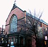 | September 25, 2008 (#08000933) | 210–216 West 134th St. 40°48′53″N73°56′43″W / 40.814672°N 73.945278°W | Harlem | |
| 93 | St. Walburga's Academy |  | July 28, 2004 (#04000755) | 630 Riverside Dr. (@ 140th) 40°49′27″N73°57′18″W / 40.824167°N 73.955°W | Hamilton Heights | |
| 94 | Schomburg Center for Research in Black Culture |  | September 21, 1978 (#78001881) | 103 W. 135th St. 40°48′52″N73°56′29″W / 40.814444°N 73.941389°W | Harlem | |
| 95 | Sheffield Farms Stable |  | November 9, 2005 (#05001285) | 3229 Broadway (@ 130th) 40°49′00″N73°57′30″W / 40.816667°N 73.958333°W | Manhattanville | |
| 96 | Students' Hall |  | November 15, 2003 (#03001150) | Barnard College, 3005 Broadway 40°48′32″N73°57′52″W / 40.808889°N 73.964444°W | Morningside Heights | built in 1916, now known as Barnard Hall |
| 97 | Substation 17 |  | February 9, 2006 (#06000025) | 127–129 Hillside Ave. (nr Ft Tryon) 40°51′36″N73°55′37″W / 40.86°N 73.926944°W | Washington Heights | |
| 98 | Substation 219 |  | February 9, 2006 (#06000023) | 309 W. 133rd St. 40°48′56″N73°56′55″W / 40.815556°N 73.948611°W | Harlem | |
| 99 | Sugar Hill Historic District |  | April 11, 2002 (#02000360) | Roughly bounded by W. 155th St., 145th St., Bradhurst Ave. and Convent Ave. 40°49′38″N73°56′36″W / 40.827222°N 73.943333°W | Harlem | |
| 100 | Union Theological Seminary |  | April 23, 1980 (#80002725) | W. 120th St. and Broadway 40°48′41″N73°57′51″W / 40.811389°N 73.964167°W | Morningside Heights | |
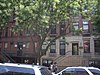
| 101 | US Post Office-Inwood Station |  | May 11, 1989 (#88002361) | 90 Vermilyea Ave. 40°51′58″N73°55′26″W / 40.866111°N 73.923889°W | Inwood | |
| 102 | Washington Bridge |  | September 22, 1983 (#83001645) | Between Amsterdam and Undercliff Aves. 40°50′42″N73°55′29″W / 40.845°N 73.924722°W | Washington Heights | |
| 103 | West 114th Street Historic District |  | July 16, 2014 (#14000399) | 204–246 & 215–277 W. 114th St. 40°48′09″N73°57′18″W / 40.8025°N 73.955°W | Morningside Heights | Brick rowhouses erected in last years of 19th century eventually became one of Harlem's most desirable blocks when African-Americans started moving in during Great Migration. |
| 104 | West 147th–149th Streets Historic District |  | May 18, 2003 (#03000407) | Roughly bounded by Eighth Ave., W. 149th St., Seventh Ave., and W. 147th Ave. 40°49′26″N73°56′22″W / 40.823889°N 73.939444°W | Harlem | |
| 105 | West Harlem Historic District | November 10, 2022 (#100008341) | West 135th to West 153rd Sts. between Amsterdam Ave. and Riverside Dr. 40°49′35″N73°57′02″W / 40.8263°N 73.9506°W | Harlem |