
The Erie Canal is a historic canal in upstate New York that runs east–west between the Hudson River and Lake Erie. Completed in 1825, the canal was the first navigable waterway connecting the Atlantic Ocean to the Great Lakes, vastly reducing the costs of transporting people and goods across the Appalachians. The Erie Canal accelerated the settlement of the Great Lakes region, the westward expansion of the United States, and the economic ascendancy of New York state. It has been called "The Nation's First Superhighway."

The St. Lawrence Seaway is a system of locks, canals, and channels in Canada and the United States that permits oceangoing vessels to travel from the Atlantic Ocean to the Great Lakes of North America, as far inland as Duluth, Minnesota, at the western end of Lake Superior. The seaway is named for the St. Lawrence River, which flows from Lake Ontario to the Atlantic Ocean. Legally, the seaway extends from Montreal, Quebec, to Lake Erie, and includes the Welland Canal. Ships from the Atlantic Ocean are able to reach ports in all five of the Great Lakes, via the Great Lakes Waterway.

The Hudson River is a 315-mile (507 km) river that flows from north to south primarily through eastern New York, United States. It originates in the Adirondack Mountains of upstate New York at Henderson Lake in the town of Newcomb, and flows southward through the Hudson Valley to the New York Harbor between New York City and Jersey City, eventually draining into the Atlantic Ocean at Upper New York Bay. The river serves as a physical boundary between the states of New Jersey and New York at its southern end. Farther north, it marks local boundaries between several New York counties. The lower half of the river is a tidal estuary, deeper than the body of water into which it flows, occupying the Hudson Fjord, an inlet that formed during the most recent period of North American glaciation, estimated at 26,000 to 13,300 years ago. Even as far north as the city of Troy, the flow of the river changes direction with the tides.

The Monongahela River, sometimes referred to locally as the Mon, is a 130-mile-long (210 km) river on the Allegheny Plateau in north-central West Virginia and Southwestern Pennsylvania. The river flows from the confluence of its west and east forks in north-central West Virginia northeasterly into southwestern Pennsylvania, then northerly to Pittsburgh and its confluence with the Allegheny River to form the Ohio River. The river includes a series of locks and dams that makes it navigable.
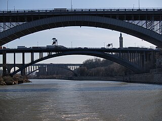
The Harlem River is an 8-mile (13 km) tidal strait in New York City, New York, flowing between the Hudson River and the East River and separating the island of Manhattan from the Bronx on the United States mainland.
The Hertford Union Canal or Duckett's Cut, just over 1 mile (1.6 km) long, connects the Regent's Canal to the Lee Navigation in the London Borough of Tower Hamlets in East London. It was opened in 1830 but quickly proved to be a commercial failure. It was acquired by the Regents Canal Company in 1857, and became part of the Grand Union Canal in 1927.

The Miami and Erie Canal was a 274-mile (441 km) canal that ran from Cincinnati to Toledo, Ohio, creating a water route between the Ohio River and Lake Erie. Construction on the canal began in 1825 and was completed in 1845 at a cost to the state government of $8 million. At its peak, it included 19 aqueducts, three guard locks, 103 canal locks, multiple feeder canals, and a few man-made water reservoirs. The canal climbed 395 feet (120 m) above Lake Erie and 513 feet (156 m) above the Ohio River to reach a topographical peak called the Loramie Summit, which extended 19 miles (31 km) between New Bremen, Ohio to lock 1-S in Lockington, north of Piqua, Ohio. Boats up to 80 feet long were towed along the canal by mules, horses, or oxen walking on a prepared towpath along the bank, at a rate of four to five miles per hour.

The Tennessee–Tombigbee Waterway is a 234-mile (377 km) artificial U.S. waterway built in the 20th century from the Tennessee River to the junction of the Black Warrior-Tombigbee River system near Demopolis, Alabama. The Tennessee–Tombigbee Waterway links commercial navigation from the nation's midsection to the Gulf of Mexico. The major features of the waterway are 234 miles (377 km) of navigation channels, a 175-foot-deep (53 m) cut between the watersheds of the Tombigbee and Tennessee rivers, and ten locks and dams. The locks are 9 by 110 by 600 feet, the same dimension as those on the Mississippi above Lock and Dam 26 at Alton, Illinois. Under construction for 12 years by the U.S. Army Corps of Engineers, the Tennessee–Tombigbee Waterway was completed in December 1984 at a total cost of nearly $2 billion.

The Warren County Canal was a branch of the Miami and Erie Canal in southwestern Ohio about 20 miles (32 km) in length that connected the Warren County seat of Lebanon to the main canal at Middletown in the mid-19th century. Lebanon was at the crossroads of two major roads, the highway from Cincinnati to Columbus and the road from Chillicothe to the College Township (Oxford), but Lebanon businessmen and civic leaders wanted better transportation facilities and successfully lobbied for their own canal, part of the canal fever of the first third of the 19th century. The Warren County Canal was never successful, operating less than a decade before the state abandoned it.

The Main Line of Public Works was a package of legislation passed by the Commonwealth of Pennsylvania in 1826 to establish a means of transporting freight between Philadelphia and Pittsburgh. It funded the construction of various long-proposed canal and road projects, mostly in southern Pennsylvania, that became a canal system and later added railroads. Built between 1826 and 1834, it established the Pennsylvania Canal System and the Allegheny Portage Railroad.

The Cayuga–Seneca Canal is a canal in New York, United States. It is now part of the New York State Canal System. The canal connects the Erie Canal to Cayuga Lake and Seneca Lake and is approximately 20 miles (32 km) long. A multi-use trail runs beside a portion of the canal.
The Oswego Canal is a canal in the New York State Canal System located in New York, United States. Opened in 1828, it is 23.7 miles (38.1 km) in length, and connects the Erie Canal at Three Rivers to Lake Ontario at Oswego. The canal has a depth of 14 ft (4.3 m), with seven locks spanning the 118 ft (36 m) change in elevation.

The Champlain Canal is a 60-mile (97 km) canal in New York that connects the Hudson River to the south end of Lake Champlain. It was simultaneously constructed with the Erie Canal for use by commercial vessels, fully opening in 1823. Today, it is mostly used by recreational boaters as part of the New York State Canal System and Lakes to Locks Passage.

Cohoes Falls [Kahón:iosKanien'ké:ha for "a boat is in the water / is actively submerged"] is a waterfall on the Mohawk River shared by the city of Cohoes and the town of Waterford, New York.

The Stainforth and Keadby Canal is a navigable canal in South Yorkshire and Lincolnshire, England. It connects the River Don Navigation at Bramwith to the River Trent at Keadby, by way of Stainforth, Thorne and Ealand, near Crowle. It opened in 1802, passed into the control of the River Don Navigation in 1849, and within a year was controlled by the first of several railway companies. It became part of the Sheffield and South Yorkshire Navigation, an attempt to remove several canals from railway control, in 1895. There were plans to upgrade it to take larger barges and to improve the port facilities at Keadby, but the completion of the New Junction Canal in 1905 made this unnecessary, as Goole could easily be reached and was already a thriving port.

The Lehigh Canal is a navigable canal that begins at the mouth of Nesquehoning Creek on the Lehigh River in the Lehigh Valley and Northeastern regions of Pennsylvania. It was built in two sections over a span of 20 years beginning in 1818. The lower section spanned the distance between Easton and present-day Jim Thorpe. In Easton, the canal met the Pennsylvania Canal's Delaware Division and Morris Canals, which allowed anthracite coal and other goods to be transported further up the U.S. East Coast. At its height, the Lehigh Canal was 72 miles (116 km) long.

The Poesten Kill is a 26.2-mile-long (42.2 km) creek in Rensselaer County, Upstate New York. It flows westerly from its source at Dyken Pond, located in the town of Berlin, to its mouth at the Hudson River in the city of Troy. The creek was historically used as a source of water for the local farmers and residents. During the Industrial Revolution, the creek became an important source of water power, and many mills and factories sprung up along its banks.

Starved Rock Lock and Dam, also known as Lock and Dam No. 6, is a lock and dam facility managed by the U.S. Army Corps of Engineers along the Illinois River, near Starved Rock. It is part of the Illinois Waterway and was constructed between 1926 and 1933. The lock and dam was added to the National Register of Historic Places as the Starved Rock Lock and Dam Historic District in 2004.

The Waterford Flight is a set of locks on the Erie Canal in upstate New York. Erie Canal Locks E-2 through E-6 make up the combined flight at Waterford, which lifts vessels from the Hudson River to the Mohawk River, bypassing Cohoes Falls. Built in 1915, the Waterford Flight is still in use today as part of the New York State Canal System, which is open to public and commercial traffic. The Waterford Flight is the series of locks with the highest elevation gain relative to its length for any canal lock system in the United States.

Aqueduct is a hamlet in the Town of Niskayuna, Schenectady County, New York, United States. Its center is at the south end of the bridge of New York State Route 146 over the Mohawk River, that connects Schenectady County to the south and Saratoga County to the north. It was formerly a transportation hub. Alexander's Bridge across the Mohawk antedated the Aqueduct. A new Route 146 steel highway bridge, with board pavement, parallel to the Aqueduct was built in the early 20th century. A Schenectady trolley line ended there, the line also serving Luna Park, just over the river in Rexford. There was, in Aqueduct, a staffed station of the Troy & Schenectady Railroad, which operated from 1841 to 1932.
