Related Research Articles

Oelwein is a city in Fayette County, Iowa, United States. The population was 5,920 at the time of the 2020 census, a decrease of 11.5% from the 2000 census. The largest community in Fayette County, it is located at the junction of State Highways 3 and 150.

Little Elm is a city in Denton County, Texas, United States, and a part of the Dallas–Fort Worth metroplex. It is an extended suburb of Denton; its population was 46,453 as of the 2020 census. In 2000, the census population was at 3,646. By the 2010 census, the city total had jumped to 25,898, making Little Elm one of the fastest-growing municipalities by percentage in Texas since 2000. The July 1, 2021 census estimates Little Elm's population as 51,042.

Robert Moses was an American urban planner and public official who worked in the New York metropolitan area during the early to mid 20th century. Despite never being elected to any office, Moses is regarded as one of the most powerful and influential individuals in the history of New York City and New York State. The grand scale of his infrastructural projects and his philosophy of urban development influenced a generation of engineers, architects, and urban planners across the United States.

Bayview Village is an neighbourhood in Toronto, Ontario, Canada. It is part of the federal Don Valley North riding and the provincial Don Valley North electoral district, and Toronto electoral Ward 17: Don Valley North. In 2006, it had a population of 15,370.

Parkway Forest is a neighbourhood in Toronto, Ontario, Canada. It is located in the north of the city, in the former suburb of North York. Parkway Forest is bounded on the west by Don Mills Road, on the north by Sheppard Avenue, on the east by the Don Valley Parkway, and on the south by Highway 401. It is contained within the city's officially designated neighbourhood of Henry Farm, although it is distinct in character from the residential community of that same name west of Don Mills Road. Parkway Forest is part of Ward 17 in the Toronto City Council, part of the new Don Valley North federal electoral district, and part of the Don Valley East provincial electoral district.
Tomball Independent School District is a K-12 education school district serving Tomball, Texas, United States as well as the surrounding area.

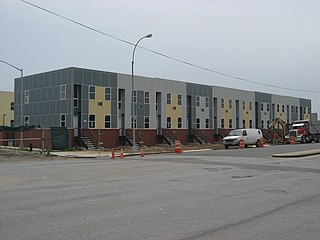
Starrett City is a housing development in the Spring Creek section of East New York, in Brooklyn, New York City. It is located on a peninsula on the north shore of Jamaica Bay, bounded by Fresh Creek to the west and Hendrix Creek to the east. Starrett City contains both residential and commercial buildings. The residential portion of the property contains eight "sections" in a towers in the park layout. The complex also contains a community and recreation center, as well as two schools.
Clayton Park is a community within Halifax, Nova Scotia, Canada.

Urbana is a suburban census-designated place located in Frederick County, Maryland, United States. It lies at the I-270/MD 80 interchange, approximately 7.5 miles (12.1 km) south-east of Frederick and about 37 miles (60 km) north-west of Washington, D.C. Urbana started to develop circa 1999 and, as of the 2010 census, had a population of 9,175. It is part of the Washington metropolitan area.

Fourth Ward is one of the historic six wards of Houston, Texas, United States. The Fourth Ward is located inside the 610 Loop directly west of and adjacent to Downtown Houston. The Fourth Ward is the site of Freedmen's Town, which was a post-U.S. Civil War community of African-Americans.

Torrance Unified School District (TUSD) is a school district in Los Angeles County, California, with its headquarters in Torrance.
The Near East Side is a neighborhood located near downtown Columbus, Ohio, made up of several neighborhoods: Mount Vernon, King-Lincoln Bronzeville, Eastgate, Franklin Park, Nelson Park, Olde Towne East, and Woodland Park.

Serra Mesa is a community in San Diego, California, roughly between Interstate 805 and Interstate 15, north of Friars Road and south of Aero Drive. It is named for Junípero Serra, a Majorcan (Spain) Franciscan friar who founded the Mission San Diego de Alcalá. Adjacent communities include Kearny Mesa, Tierrasanta, Mission Valley, and Linda Vista.

Washington Highlands is a residential neighborhood in Southeast Washington, D.C., in the United States. It lies within Ward 8.
The Urban Growth and New Community Development Act is a statute enacted by the United States Congress in 1970.

Bartram Springs is a master-planned residential community located in Jacksonville, Florida. It resides on the Duval County and St. Johns County line.
Spring Creek, previously called Spring Creek Basin, is a neighborhood within the East New York section of Brooklyn in New York City. It roughly comprises the southern portions of East New York between Flatlands Avenue to the north, and Jamaica Bay and the Gateway National Recreation Area to the south, with the Brooklyn neighborhood of Canarsie to the west and the Queens neighborhood of Howard Beach to the east. It is named after Spring Creek, one of several creeks that formerly ran through the area and drained into Jamaica Bay.

Riverstone is a 3,700-acre (15 km2) upscale master-planned residential community in Fort Bend County, Texas. About 18,000 residents ultimately will live in 6000 homes. The development is largely located in the unincorporated areas of Sugar Land and Missouri City, with a portion being in Missouri City proper.

Historic Oaks of Allen Parkway Village, formerly Allen Parkway Village (APV) and San Felipe Courts Apartments, is a public housing complex in the northern Fourth Ward, Houston, Texas, operated by the Houston Housing Authority (HHA). Allen Parkway Village occupies 37 acres (15 ha) of land.
African American Library at the Gregory School is a branch of the Houston Public Library (HPL) in the Fourth Ward, Houston. The library preserves historical information about the African-American community in Houston. It is the city's first library to focus on African-American history and culture. The library features galleries, an oral history recording room, and reading rooms. $11 million from federal community development block grants and construction funds from Houston Public Library and the City of Houston financed the renovation of the Gregory facility. The building was initially used as the Edgar M. Gregory School, a K-8 school of the Houston Independent School District (HISD).
References
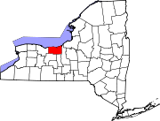
- ↑ "State of New York Census Designated Places - Current/BAS20 - Data as of January 1, 2019". tigerweb.geo.census.gov. Retrieved February 25, 2020.
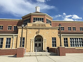
- ↑ "Gananda Central School District, NY". censusreporter.org. Retrieved February 15, 2018.
- ↑ "1973 Executive Summary of Gananda" (PDF). U.S. Department of Housing and Urban Development. Retrieved September 26, 2016.
- ↑ "Note from Grant Mitchell, Assistant General Counsel New Communities, to Robert Elliot concerning the progress of Title IV and VII new communities" (PDF). U.S. Department of Housing and Urban Development. Retrieved September 26, 2016.
- ↑ "Press Release from the Department of Housing and Urban Development entitled "History of the New Communities Program"" (PDF). U.S. Department of Housing and Urban Development. Retrieved September 26, 2016.
- ↑ "Use of Revolving Funds Under New Community Development Program" (PDF). Government Accountability Office. Retrieved February 15, 2009.
- ↑ "Wayne County, NY Tax Map detailing location of Fox Tail Park" (PDF). Wayne County Real Property Tax Service. Retrieved September 26, 2016.