
Research Natural Area is a designation for certain protected areas in the United States.

The Three Mile River or Threemile River is a river in Bristol County, Massachusetts. It is formed by the junction of the Rumford and Wading rivers in the town of Norton. It flows in a southeasterly direction for 13.5 miles (21.7 km) through the towns of Norton, Taunton and Dighton, where it joins the Taunton River.

Watson Pond is a small freshwater lake within Watson Pond State Park, in Taunton, Massachusetts, United States. The lake is connected to Lake Sabbatia and much of its coastline is forested. The lake is open to the public for swimming and ice fishing.
The Fish Slough Area of Critical Environmental Concern is a protected slough in Inyo County, eastern California. It is located on the western side of the Chalfant Valley, 5 miles (8.0 km) north of Bishop in the northern Owens Valley area.

The Jawbone–Butterbredt Area of Critical Environmental Concern (ACEC), is located in the Mojave Desert and Southern Sierra Nevada, northwest of California City and California State Route 14, in Kern County, California.

The New River is a stream, about 8 miles (13 km) long, on the southern coast of the U.S. state of Oregon. It begins slightly north of Floras Lake, at the confluence of the lake outlet and Floras Creek, and runs north behind a foredune until entering the Pacific Ocean between Bandon and Port Orford.

The Canoe River is a river in southeastern Massachusetts. It is 14.4 miles (23.2 km) long and part of the Taunton River Watershed.

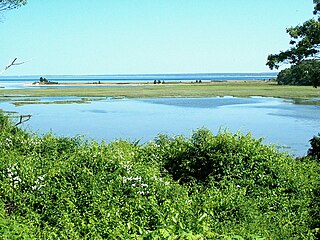
The Pocasset River is a small tidal river and estuary on the eastern shore of Buzzards Bay, in Bourne, Massachusetts, United States. It is located between the villages of Monument Beach and Pocasset along the western coast of Cape Cod. The river flows westward through a series of small ponds and wetlands, with a total length of about 2 miles (3.2 km).
Areas of Critical Environmental Concern (ACEC) is a conservation ecology program in the Western United States, managed by the Bureau of Land Management (BLM). The ACEC program was conceived in the 1976 Federal Lands Policy and Management Act (FLPMA), which established the first conservation ecology mandate for the BLM. The FLPMA mandate directs the BLM to protect important riparian corridors, threatened and endangered species habitats, cultural and archeological resources, as well as unique scenic landscapes that the agency assesses as in need of special management attention.
Ellisville Harbor State Park is a nature preserve and public recreation area located in the village of Ellisville, Massachusetts, on the western shore of Cape Cod Bay. Natural features of the coastal property include a barrier beach, sphagnum bog, salt marsh, rolling meadows, and red pine forest habitats. Scenic features include views of the South Shore coastline, small fishing boats, harbor seals seen offshore during fall and winter, and birds attracted to the park's bog as both habitat and migration stopover. The state park is managed by the Department of Conservation and Recreation.
The Massachusetts Executive Office of Energy and Environmental Affairs (EOEEA) is a Cabinet level agency under the Governor of Massachusetts. EOEEA is responsible for promoting efficient energy use throughout the Commonwealth while protecting and preserving Massachusetts' natural environment.

Oxbow National Wildlife Refuge is a property of the United States National Wildlife Refuge (NWR) system located in Middlesex and Worcester counties in Massachusetts. It was founded in 1974.
The American Council of Engineering Companies of California is a statewide group representing consulting engineering and land surveying firms in California. The organization promotes use of the private sector in the growth and improvement of California. The ACEC California membership provides engineering, surveying, construction management and environmental consulting services for all project phases.
The American Council of Engineering Companies (ACEC) is the oldest and largest business association of engineering companies. It is organized as a federation of 52 state and regional councils with national headquarters in Washington, D.C., comprising thousands of engineering practices throughout the country. It administers extensive lobbying and education programs.

The South Fork Eel River Wilderness is a 12,868-acre (5,207 ha) wilderness area located in Mendocino County, California. The wilderness was added to the National Wilderness Preservation System when the United States Congress passed the Northern California Coastal Wild Heritage Wilderness Act in 2006. The Department of the Interior's Bureau of Land Management (BLM) is the agency in charge.

The Snake River is a small river in Bristol County, Massachusetts. It flows 4.0 miles (6.4 km) from Winnecunnet Pond to Lake Sabbatia in the northern part of Taunton, Massachusetts.
The Back River is a small tidal estuary in Bourne, Massachusetts on the eastern shore of Buzzards Bay. It lies just south of the Cape Cod Canal near the village of Monument Beach. It is separated from Buzzards Bay by Phinneys Harbor. The river's length is 2.1 miles (3.4 km).

Floras Lake is a natural 236-acre (96 ha) body of water on the southern Oregon Coast of the United States. Fed by four small tributaries from a basin of about 10 square miles (26 km2) in Curry County, it lies about 10 miles (16 km) north of Port Orford and 2 miles (3 km) west of U.S. Route 101. It was probably named for Fred Flora, a 19th-century settler and miner who lived nearby.

Mormon Mesa is a mesa between the Virgin River and the Muddy River in Clark County, southern Nevada.


