
The Pawcatuck River is a river in the US states of Rhode Island and Connecticut flowing approximately 34 miles (55 km). There are eight dams along the river's length. USS Pawcatuck was named after the river.
The River Moselle, also referred to as Moselle Brook, is in North London and flows through Tottenham towards the Lea Valley. The river was originally a tributary of the River Lea, but it now flows into Pymmes Brook, another Lea tributary.

The Seekonk River is a tidal extension of the Providence River in the U.S. state of Rhode Island. It flows approximately 8 km (5 mi). The name may be derived from an Algonquian word for skunk or for black goose. The river is home to the Brown University men's rowing team, India Point Park, Blackstone Park Conservation District, Crook Point Bascule Bridge, Narragansett Boat Club, Swan Point Cemetery, and the Bucklin Point waste-water treatment facility. The River is listed by the Rhode Island Department of Environmental Management as an impaired waterway.

The Meers Brook is a stream in Sheffield, England and one of the main tributaries of the River Sheaf. The Meers Brook originates in Gleadless and flows downhill through Gleadless Valley and Meersbrook then, culverted, continues underneath Heeley to pour into the River Sheaf near Saxon Road and Clyde Road in Lowfield.

The Pawtuxet River, also known as the Pawtuxet River Main Stem and the Lower Pawtuxet, is a river in the U.S. state of Rhode Island. It flows 12.3 miles (19.8 km) and empties into the upper Narragansett Bay of the Atlantic Ocean. Together with its two main tributary branches, the North Branch Pawtuxet River and the South Branch Pawtuxet River, it drains a watershed of 231.6 square miles (600 km2), all of which is in the state of R.I.
The Malden River is a 2.3-mile-long (3.7 km) river in Malden, Medford, and Everett, Massachusetts. It is roughly 675 feet (206 m) wide at its widest point and is very narrow at its smallest point. Its banks are largely occupied by industrial business, and the river is scarcely used or even mentioned. Its water quality is worse than most local waters, including the Mystic River, into which it flows.
The Bungay River is a short river in southeastern Massachusetts that is a tributary of the Ten Mile River.

The Ten Mile River is a river within the U.S. states of Massachusetts and Rhode Island. It flows approximately 22 miles (35 km) and drains a watershed of 54 square miles (140 km2).

The Wood River is a river in the U.S. states of Connecticut and Rhode Island. It flows approximately 25 miles (40 km) and is a major tributary of the Pawcatuck River. There are 8 dams along the river's length.
The Sevenmile River or Seven Mile River is a river which flows through U.S. states of Massachusetts and Rhode Island. It flows approximately 9.8 miles (15.8 km).
The Runnins River is a river in the U.S. states of Massachusetts and Rhode Island. It flows approximately 14 km (9 mi).
Abbott Run is a de facto river in the U.S. state of Massachusetts and Rhode Island. It flows approximately 10 miles (16 km).

Piethorne Brook is a watercourse in Greater Manchester. It is a tributary of the River Beal.
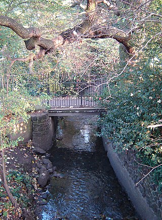
Blageddy Stream is a small brook in Slater Park in Pawtucket, Rhode Island. It connects the Slater Park Duck Pond, Friendship Gardens Pond, and the Blageddy Swamp to the Ten Mile River. Originally, the Blaggeddy Stream was a much larger Swamp before the creation of the park. The water that was there was routed into a narrow channel, which is the Blageddy Stream that is there today. The brook is formed by two channels. One flows north out of Friendship Gardens. The other flows south out of the Blaggeddy Swamp. They meet in a culvert and enter the Duck Pond, before flowing east into the Ten Mile River.
The Sheldrake River is a freshwater stream located in Southern Westchester County, New York. The river forms in White Plains and flows six miles (9.7 km) south until it joins the Mamaroneck River. Approximately 1.58 miles (2.54 km) of the Sheldrake River flow through Scarsdale, 2.13 miles (3.43 km) through New Rochelle and two miles (3.2 km) through the Town of Mamaroneck.
Stafford Meadow Brook is a tributary of the Lackawanna River in Lackawanna County, Pennsylvania, in the United States. It is approximately 11.2 miles (18.0 km) long and flows through Roaring Brook Township, Scranton, and Moosic. The watershed of the stream has an area of 14.1 square miles (37 km2). Part of it is designated as a High-Quality Coldwater Fishery and a Migratory Fishery. The other part is a Warmwater Fishery and a Migratory Fishery. The stream has one named tributary, which is known as Mountain Lake Run. Stafford Meadow Brook has a very high level of water quality for much of its length and part of it meets the criteria for an Exceptional Value designation. The stream begins on the Pocono Plateau and flows through the Moosic Mountains in a mountainous watershed. Its channel has been substantially altered in its lower reaches.
Meadow Brook is a tributary of the Lackawanna River in Lackawanna County, Pennsylvania, in the United States. It is approximately 2.0 miles (3.2 km) long and flows through Dunmore and Scranton. The watershed of the stream has an area of 2.43 square miles (6.3 km2), though it used to be considerably larger. It is designated as a Coldwater Fishery and a Migratory Fishery, but many reaches of the stream have been destroyed by mining or post-mining development impacts. The stream flows through a culvert system for much of its length. However, there are areas where it is in an open concrete channel or has a natural streambed. There are also patches of old-growth forest along the stream in the Forest Hill Cemetery.
Coal Brook is a tributary of the Lackawanna River in Lackawanna County, Pennsylvania, in the United States. It is approximately 2.2 miles (3.5 km) long and flows through Fell Township and Carbondale. The watershed of the stream has an area of 1.93 square miles (5.0 km2). The stream experiences flow loss and is impaired by flow alterations and metals. Most of its length is heavily impacted by past mining and the lower reaches are in an underground culvert. The Coal Brook Colliery was historically in the stream's watershed. Coal Brook is a first-order stream and is designated as a Coldwater Fishery and a Migratory Fishery.

Moston Brook is a stream in Greater Manchester in north-west England and a tributary of the River Irk. The brook is formed at the confluence of Bower Brook and Hole Bottom Brook. This occurs near the Rochdale Canal in Failsworth in the Metropolitan Borough of Oldham. It flows southwest, forming the border between Moston, Manchester and Failsworth before being culverted almost all of the remaining route to its meeting the River Irk. It has a total length of about 3.7 miles.

Rattlesnake Creek is an underground waterway in the northeast Bronx, New York City. It flowed above ground level until the mid-20th century, with a waterfall and a pond over its course. Rattlesnake Creek has since been mostly covered over, but a small portion of it is still visible in Seton Falls Park.