National Register of Historic Places listings in Pawtucket, Rhode Island

Last updated

Location of Pawtucket in Providence County, Rhode Island Pawtucket RI highlight.PNG
Location of Pawtucket in Providence County, Rhode Island

This is a list of the National Register of Historic Places listings in Pawtucket, Rhode Island.

Contents

This is intended to be a complete list of the properties and districts on the National Register of Historic Places in Pawtucket, Rhode Island, United States. Latitude and longitude coordinates are provided for many National Register properties and districts; these locations may be seen together in an online map. [1]

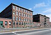
There are 434 properties and districts listed on the National Register in Providence County, including 15 National Historic Landmarks. The city of Pawtucket is the location of 57 these properties and districts, including 1 National Historic Landmark; they are listed here. Properties and districts located in the county's other municipalities are listed separately. Two Pawtucket listings, the Blackstone Canal and the Conant Thread-Coats & Clark Mill Complex District, extend into other parts of Providence County, and appear on multiple lists.

Contents: Counties in Rhode Island

Bristol | Kent | Newport | Providence | Washington


    This National Park Service list is complete through NPS recent listings posted February 9, 2024. [2]
Map all coordinates using: OpenStreetMap

Current listings

[3] Name on the Register [4] ImageDate listed [5] Location City or townDescription
1 John E. Adams House
John E. Adams House PawtucketRI JohnEAdamsHouse.jpg
John E. Adams House
November 18, 1983
(#83003804)
11 Allen Ave.
41°52′59″N71°22′38″W / 41.883056°N 71.377222°W / 41.883056; -71.377222 (John E. Adams House)
Pawtucket
2 Art's Auto
Art's Auto One Lonsdale Avenue, Pawtucket RI.jpg
Art's Auto
December 15, 1978
(#78000071)
5-7 Lonsdale Ave.
41°52′07″N71°23′56″W / 41.868611°N 71.398889°W / 41.868611; -71.398889 (Art's Auto)
Pawtucket
3 Blackstone Canal
Blackstone Canal PawtucketRI BlackstoneCanalAtWeedenStreet.jpg
Blackstone Canal
May 6, 1971
(#71000030)
From Steeple and Promenade Sts. in Providence to the Massachusetts border in North Smithfield
41°55′16″N71°25′21″W / 41.921111°N 71.4225°W / 41.921111; -71.4225 (Blackstone Canal)
Pawtucket, Lincoln, Woonsocket, and North Smithfield 
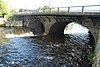
Initial listing extended from Providence, through Pawtucket, and as far north as Lincoln; a 1991 expansion (#91001536) extended it to the state line; the canal itself extended into Worcester County, Massachusetts, where it is the subject of separate listings.
4 Bridge Mill Power Plant
Bridge Mill Power Plant Pawtucket Power Plant.jpg
Bridge Mill Power Plant
November 18, 1983
(#83003805)
25 Roosevelt Ave.
41°52′35″N71°23′04″W / 41.876389°N 71.384444°W / 41.876389; -71.384444 (Bridge Mill Power Plant)
Pawtucket
5 G.A. Burnham House
G.A. Burnham House 17 Nickerson Street, Pawtucket RI.jpg
G.A. Burnham House
November 18, 1983
(#83003806)
17 Nickerson St.
41°52′58″N71°23′20″W / 41.882778°N 71.388889°W / 41.882778; -71.388889 (G.A. Burnham House)
Pawtucket
6 Childs-Brown House
Childs-Brown House Childs-Brown House, Pawtucket RI.jpg
Childs-Brown House
November 18, 1983
(#83003807)
172 Pine St.
41°52′28″N71°23′23″W / 41.874397°N 71.389739°W / 41.874397; -71.389739 (Childs-Brown House)
Pawtucket
7 Church Hill Grammar School
Church Hill Grammar School Church Hill Grammar School Pawtucket RI.jpg
Church Hill Grammar School
April 23, 2010
(#10000165)
81 Park Pl.
41°52′33″N71°23′16″W / 41.875878°N 71.387694°W / 41.875878; -71.387694 (Church Hill Grammar School)
Pawtucket
8 Church Hill Industrial District
Church Hill Industrial District Church Street Pawtucket.jpg
Church Hill Industrial District
August 12, 1982
(#82000135)
Roughly bounded by S. Union, Pine, Baley, Commerce, Main, and Hill Sts.
Boundary increase (listed 2/7/2011): 60 Dexter St., 125 Goff Ave., 265 Pine St.

41°52′34″N71°23′22″W / 41.8761°N 71.3894°W / 41.8761; -71.3894 (Church Hill Industrial District)
Pawtucket
9 Collyer Monument
Collyer Monument Collyer Monument, Pawtucket RI.jpg
Collyer Monument
November 18, 1983
(#83003808)
Mineral Spring Park
41°52′29″N71°23′35″W / 41.874722°N 71.393056°W / 41.874722; -71.393056 (Collyer Monument)
Pawtucket
10 Conant Thread-Coats & Clark Mill Complex District
Conant Thread-Coats & Clark Mill Complex District Conant Thread Mills.jpg
Conant Thread-Coats & Clark Mill Complex District
November 18, 1983
(#83003809)
Roughly bounded by Lonsdale Ave., Pine, Conant, Carpenter, and Rand Sts.
41°52′51″N71°23′53″W / 41.880833°N 71.398056°W / 41.880833; -71.398056 (Conant Thread-Coats & Clark Mill Complex District)
Pawtucket Extends into Central Falls
11 Lorenzo Crandall House
Lorenzo Crandall House PawtucketRI LorenzoCrandallHouse.jpg
Lorenzo Crandall House
December 10, 1984
(#78000072)
221 High St.
41°52′53″N71°23′03″W / 41.881389°N 71.384167°W / 41.881389; -71.384167 (Lorenzo Crandall House)
Pawtucket
12 Division Street Bridge
Division Street Bridge Division Street Bridge Pawtucket.jpg
Division Street Bridge
November 18, 1983
(#83003810)
Division St. at the Seekonk River
41°52′20″N71°23′06″W / 41.872222°N 71.385°W / 41.872222; -71.385 (Division Street Bridge)
Pawtucket
13 Donwell's Diner-Worcester Lunch Car Company Diner No. 774
Donwell's Diner-Worcester Lunch Car Company Diner No. 774 Miss Lorraine Diner, Pawtucket Rhode Island.jpg
Donwell's Diner-Worcester Lunch Car Company Diner No. 774
October 25, 2021
(#100007075)
560 Mineral Springs Ave.
41°52′22″N71°24′23″W / 41.8729°N 71.4064°W / 41.8729; -71.4064 (Donwell's Diner-Worcester Lunch Car Company Diner No. 774)
Pawtucket Currently the Lorraine Diner.
13 Downtown Pawtucket Historic District
Downtown Pawtucket Historic District Pawtucket Times.jpg
Downtown Pawtucket Historic District
April 5, 2007
(#06001227)
Roughly bounded by Broad St., Grant St., High St., the East Ave. Extension, and Main St.
41°52′43″N71°23′05″W / 41.878692°N 71.384856°W / 41.878692; -71.384856 (Downtown Pawtucket Historic District)
Pawtucket
14 Exchange Street Historic District
Exchange Street Historic District Pawtucket Armory 2013.jpg
Exchange Street Historic District
September 6, 2002
(#02000952)
Roughly along Exchange, Front and Fountain Sts.
41°52′47″N71°22′50″W / 41.879722°N 71.380556°W / 41.879722; -71.380556 (Exchange Street Historic District)
Pawtucket
15 Fifth Ward Wardroom
Fifth Ward Wardroom Fifth Ward Wardroom, Pawtucket RI.jpg
Fifth Ward Wardroom
November 18, 1983
(#83003817)
47 Mulberry St.
41°52′27″N71°23′36″W / 41.874167°N 71.393333°W / 41.874167; -71.393333 (Fifth Ward Wardroom)
Pawtucket
16 Fire Station No. 4
Fire Station No. 4 Fire Station No. 4, Pawtucket.jpg
Fire Station No. 4
November 18, 1983
(#83003819)
474 Broadway
41°53′11″N71°22′36″W / 41.886389°N 71.376667°W / 41.886389; -71.376667 (Fire Station No. 4)
Pawtucket
17 First Ward Wardroom
First Ward Wardroom PawtucketRI FirstWardWardroom.jpg
First Ward Wardroom
November 18, 1983
(#83003820)
171 Fountain St.
41°53′04″N71°22′41″W / 41.884372°N 71.378075°W / 41.884372; -71.378075 (First Ward Wardroom)
Pawtucket Now a VFW hall.
18 Foster-Payne House
Foster-Payne House 25 Belmont Street, Pawtucket RI.jpg
Foster-Payne House
November 18, 1983
(#83003823)
25 Belmont St.
41°51′46″N71°23′45″W / 41.862792°N 71.395806°W / 41.862792; -71.395806 (Foster-Payne House)
Pawtucket
19 Fuller Houses
Fuller Houses Fuller Houses, Pawtucket RI.jpg
Fuller Houses
November 18, 1983
(#83003825)
339-341 and 343-345 Broadway
41°53′04″N71°22′38″W / 41.884444°N 71.377222°W / 41.884444; -71.377222 (Fuller Houses)
Pawtucket
20 Gately Building
Gately Building Gately Building, Pawtucket, RI-2.jpg
Gately Building
March 20, 2012
(#12000135)
335 Main St.
41°52′09″N71°23′21″W / 41.869167°N 71.389167°W / 41.869167; -71.389167 (Gately Building)
Pawtucket
21 Gilbane's Service Center Building
Gilbane's Service Center Building Gilbanes Service Center Building, Pawtucket RI.jpg
Gilbane's Service Center Building
November 18, 1983
(#83003827)
175-191 Pawtucket Ave.
41°52′09″N71°23′21″W / 41.869167°N 71.389167°W / 41.869167; -71.389167 (Gilbane's Service Center Building)
Pawtucket
22 Hope Webbing Company Mill
Hope Webbing Company Mill Hope Webbing Pawt.jpg
Hope Webbing Company Mill
April 19, 2006
(#06000297)
999-1005 Main St.
41°51′46″N71°24′04″W / 41.862778°N 71.401111°W / 41.862778; -71.401111 (Hope Webbing Company Mill)
Pawtucket
23 Jenckes Spinning Company
Jenckes Spinning Company Jenckes Spinning Company Pawtucket, Rhode Island-windows.jpg
Jenckes Spinning Company
January 25, 2018
(#100002059)
Weeden, Barton, Pine, Lily Pond & Conant Sts.
41°52′43″N71°23′35″W / 41.878677°N 71.393095°W / 41.878677; -71.393095 (Jenckes Spinning Company)
Pawtucket
24 Louis Kotzow House
Louis Kotzow House Louis Kotzow House, Pawtucket RI.jpg
Louis Kotzow House
November 18, 1983
(#83003829)
641 East Ave.
41°51′37″N71°23′24″W / 41.860278°N 71.39°W / 41.860278; -71.39 (Louis Kotzow House)
Pawtucket
25 Leroy Theatre
Leroy Theatre LeroyTheater.jpg
Leroy Theatre
August 4, 1983
(#83000181)
66 Broad St.
41°52′48″N71°23′15″W / 41.88°N 71.3875°W / 41.88; -71.3875 (Leroy Theatre)
Pawtucket Demolished in 1996.
26 Liberty Arming the Patriot
Liberty Arming the Patriot Liberty Arming the Patriot, Pawtucket, RI.jpg
Liberty Arming the Patriot
October 19, 2001
(#01000467)
Park Place
41°52′37″N71°23′14″W / 41.876944°N 71.387222°W / 41.876944; -71.387222 (Liberty Arming the Patriot)
Pawtucket
27 Main Street Bridge
Main Street Bridge Main Bridge Pawtucket.jpg
Main Street Bridge
November 18, 1983
(#83003832)
Main St. at Pawtucket Falls
41°52′35″N71°23′02″W / 41.876389°N 71.383889°W / 41.876389; -71.383889 (Main Street Bridge)
Pawtucket
28 Mitchell-Arnold House
Mitchell-Arnold House 41 Waldo Street, Pawtucket RI.jpg
Mitchell-Arnold House
November 18, 1983
(#83003833)
41 Waldo St.
41°51′58″N71°23′27″W / 41.866111°N 71.390833°W / 41.866111; -71.390833 (Mitchell-Arnold House)
Pawtucket
29 Modern Diner
Modern Diner Modern Diner Pawtucket RI 2012.jpg
Modern Diner
October 19, 1978
(#78000002)
364 East Ave.
41°52′08″N71°23′13″W / 41.868889°N 71.386944°W / 41.868889; -71.386944 (Modern Diner)
Pawtucket
30 Nathaniel Montgomery House
Nathaniel Montgomery House Nathaniel Montgomery House, Pawtucket RI.jpg
Nathaniel Montgomery House
January 19, 1984
(#84002030)
178 High St.
41°52′51″N71°23′05″W / 41.880833°N 71.384722°W / 41.880833; -71.384722 (Nathaniel Montgomery House)
Pawtucket
31 Moore Fabric Company Plant December 19, 2019
(#100004785)
45-47 Washington St.
41°52′13″N71°23′35″W / 41.8704°N 71.3930°W / 41.8704; -71.3930 (Moore Fabric Company Plant)
Pawtucket
32 Old Slater Mill
Old Slater Mill Slater Mill close.jpg
Old Slater Mill
November 13, 1966
(#66000001)
Roosevelt Ave.
41°52′39″N71°22′57″W / 41.8775°N 71.3825°W / 41.8775; -71.3825 (Old Slater Mill)
Pawtucket
33 Pawtucket Armory
Pawtucket Armory Pawt Armory.jpg
Pawtucket Armory
November 18, 1983
(#83003836)
172 Exchange St.
41°52′49″N71°22′49″W / 41.880278°N 71.380278°W / 41.880278; -71.380278 (Pawtucket Armory)
Pawtucket
34 Pawtucket City Hall
Pawtucket City Hall Pawtucket City Hall.jpg
Pawtucket City Hall
November 18, 1983
(#83003838)
137 Roosevelt Ave.
41°52′45″N71°22′57″W / 41.879167°N 71.3825°W / 41.879167; -71.3825 (Pawtucket City Hall)
Pawtucket
35 Pawtucket Congregational Church
Pawtucket Congregational Church Pawt church.jpg
Pawtucket Congregational Church
September 18, 1978
(#78000004)
40 and 56 Walcott St.
41°52′36″N71°22′54″W / 41.876667°N 71.381667°W / 41.876667; -71.381667 (Pawtucket Congregational Church)
Pawtucket Currently (2012) the church is the home to The Temple of Restoration Pentecostal Church.
36 Pawtucket Elks Lodge Building
Pawtucket Elks Lodge Building Pawtucket Elks.jpg
Pawtucket Elks Lodge Building
November 18, 1983
(#83003840)
27 Exchange
41°52′47″N71°23′08″W / 41.879781°N 71.385567°W / 41.879781; -71.385567 (Pawtucket Elks Lodge Building)
Pawtucket
37 Pawtucket Post Office
Pawtucket Post Office Former Pawtucket Post Office.jpg
Pawtucket Post Office
April 30, 1976
(#76000226)
56 High St.
41°52′42″N71°23′04″W / 41.878333°N 71.384444°W / 41.878333; -71.384444 (Pawtucket Post Office)
Pawtucket
38 Pawtucket Times Building
Pawtucket Times Building Pawtucket Times.jpg
Pawtucket Times Building
November 18, 1983
(#83003842)
23 Exchange St.
41°52′47″N71°23′09″W / 41.87975°N 71.385697°W / 41.87975; -71.385697 (Pawtucket Times Building)
Pawtucket
39 Pawtucket West High School
Pawtucket West High School Shea High School, Pawtucket RI.jpg
Pawtucket West High School
November 18, 1983
(#83003845)
485 East Ave.
41°51′55″N71°23′19″W / 41.865278°N 71.388611°W / 41.865278; -71.388611 (Pawtucket West High School)
Pawtucket
40 Charles Payne House
Charles Payne House 25 Brown Street, Pawtucket RI.jpg
Charles Payne House
November 18, 1983
(#83003847)
25 Brown St.
41°52′17″N71°23′29″W / 41.871389°N 71.391389°W / 41.871389; -71.391389 (Charles Payne House)
Pawtucket
41 Phillips Insulated Wire Company Complex
Phillips Insulated Wire Company Complex 413 Central Ave Pawtucket.jpg
Phillips Insulated Wire Company Complex
March 19, 2004
(#04000194)
413 Central Ave.
41°53′04″N71°21′59″W / 41.884444°N 71.366389°W / 41.884444; -71.366389 (Phillips Insulated Wire Company Complex)
Pawtucket
42 Pitcher-Goff House
Pitcher-Goff House Pitcher-Goff House with sign.jpg
Pitcher-Goff House
June 24, 1976
(#76000001)
58 Walcott St.
41°52′37″N71°22′49″W / 41.876944°N 71.380278°W / 41.876944; -71.380278 (Pitcher-Goff House)
Pawtucket
43 Potter-Collyer House
Potter-Collyer House Potter-Collyer House.jpg
Potter-Collyer House
November 18, 1983
(#83003849)
67 Cedar St.
41°52′24″N71°23′23″W / 41.873333°N 71.389722°W / 41.873333; -71.389722 (Potter-Collyer House)
Pawtucket
44 Prospect Heights Housing Project
Prospect Heights Housing Project PawtucketRI ProspectHeights 1.jpg
Prospect Heights Housing Project
December 15, 2015
(#15000904)
560 Prospect St.
41°51′41″N71°22′01″W / 41.861426°N 71.366949°W / 41.861426; -71.366949 (Prospect Heights Housing Project)
Pawtucket
45 Quality Hill Historic District
Quality Hill Historic District PawtucketRI QualityHill ArmisticeBlvd2.jpg
Quality Hill Historic District
April 13, 1984
(#84002041)
Roughly bounded by Interstate 95, Cottage, Lyon, Bend, and Potter Sts.
41°52′40″N71°22′25″W / 41.877778°N 71.373611°W / 41.877778; -71.373611 (Quality Hill Historic District)
Pawtucket
46 Riverside Cemetery
Riverside Cemetery PawtucketRI RiversideCemetery FalesMemorial.jpg
Riverside Cemetery
November 18, 1983
(#83003853)
724 Pleasant St.
41°51′33″N71°22′56″W / 41.859167°N 71.382222°W / 41.859167; -71.382222 (Riverside Cemetery)
Pawtucket
47 St. John the Baptist Church
St. John the Baptist Church St John the Baptist Pawtucket.jpg
St. John the Baptist Church
November 18, 1983
(#83003855)
68 Slater
41°52′24″N71°23′52″W / 41.873333°N 71.397778°W / 41.873333; -71.397778 (St. John the Baptist Church)
Pawtucket
48 St. Mary's Church of the Immaculate Conception Complex
St. Mary's Church of the Immaculate Conception Complex St. Marys Church of the Immaculate Conception, Pawtucket RI.jpg
St. Mary's Church of the Immaculate Conception Complex
November 18, 1983
(#83003856)
103 Pine St.
41°52′17″N71°23′21″W / 41.871389°N 71.389167°W / 41.871389; -71.389167 (St. Mary's Church of the Immaculate Conception Complex)
Pawtucket
49 St. Paul's Church
St. Paul's Church Saint Pauls Pawtucket.jpg
St. Paul's Church
November 18, 1983
(#83003857)
50 Park Pl.
41°52′32″N71°23′14″W / 41.875556°N 71.387222°W / 41.875556; -71.387222 (St. Paul's Church)
Pawtucket
50 Deborah Cook Sayles Public Library
Deborah Cook Sayles Public Library Pawtucket Library.jpg
Deborah Cook Sayles Public Library
December 6, 1975
(#75000002)
13 Summer St.
41°52′44″N71°23′07″W / 41.878889°N 71.385278°W / 41.878889; -71.385278 (Deborah Cook Sayles Public Library)
Pawtucket
51 Scholze-Sayles House
Scholze-Sayles House 625 East Avenue, Pawtucket RI.jpg
Scholze-Sayles House
November 18, 1983
(#83003859)
625 East Ave.
41°51′39″N71°23′21″W / 41.860783°N 71.389244°W / 41.860783; -71.389244 (Scholze-Sayles House)
Pawtucket
52 Slater Park
Slater Park Slater Park Daggett House 2 2009.JPG
Slater Park
June 30, 1976
(#76000004)
Armistice Boulevard
41°52′07″N71°20′43″W / 41.868611°N 71.345278°W / 41.868611; -71.345278 (Slater Park)
Pawtucket
53 South Street Historic District
South Street Historic District PawtucketRI SouthStreetHD 2.jpg
South Street Historic District
November 18, 1983
(#83003864)
Roughly South Street between Meadow and Fruit Sts.
41°52′17″N71°22′47″W / 41.871389°N 71.379722°W / 41.871389; -71.379722 (South Street Historic District)
Pawtucket
54 Joseph Spaulding House
Joseph Spaulding House Joseph Spaulding House, Pawtucket RI.jpg
Joseph Spaulding House
October 22, 1976
(#76000005)
30 Fruit St.
41°52′26″N71°22′50″W / 41.873889°N 71.380556°W / 41.873889; -71.380556 (Joseph Spaulding House)
Pawtucket
55 Standard Paper Box Corporation
Standard Paper Box Corporation PawtucketRI StandardPaperBoxCorp.jpg
Standard Paper Box Corporation
February 24, 2015
(#15000055)
110 Kenyon Ave.
41°53′21″N71°21′57″W / 41.889237°N 71.365800°W / 41.889237; -71.365800 (Standard Paper Box Corporation)
Pawtucket
56 Trinity Church
Trinity Church TrinityChurchPawtucket.png
Trinity Church
January 13, 1972
(#72000003)
50 Main St.
41°52′33″N71°22′52″W / 41.875886°N 71.380997°W / 41.875886; -71.380997 (Trinity Church)
Pawtucket Burned down in 2005

See also

Related Research Articles

<span class="mw-page-title-main">National Register of Historic Places listings in Franklin County, Massachusetts</span>

This is a list of the National Register of Historic Places listings in Franklin County, Massachusetts.

<span class="mw-page-title-main">National Register of Historic Places listings in Hampshire County, Massachusetts</span>

This is a list of properties on the National Register of Historic Places in Hampshire County, Massachusetts.

<span class="mw-page-title-main">National Register of Historic Places listings in Lauderdale County, Alabama</span>

This is a list of the National Register of Historic Places listings in Lauderdale County, Alabama.

<span class="mw-page-title-main">National Register of Historic Places listings in the Bronx</span>

List of Registered Historic Places in Bronx County, New York :

<span class="mw-page-title-main">National Register of Historic Places listings in Staten Island</span>

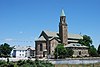
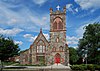
List of the National Register of Historic Places listings in Richmond County, New York.

<span class="mw-page-title-main">National Register of Historic Places listings in Scott County, Iowa</span>

This is intended to be a complete list of the properties and districts on the National Register of Historic Places in Scott County, Iowa, United States. Latitude and longitude coordinates are provided for many National Register properties and districts; these locations may be seen together in a map.

<span class="mw-page-title-main">National Register of Historic Places listings in Erie County, Ohio</span>

This is a list of the National Register of Historic Places listings in Erie County, Ohio.

<span class="mw-page-title-main">National Register of Historic Places listings in Hillsborough County, Florida</span>

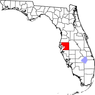
This is a list of the National Register of Historic Places listings in Hillsborough County, Florida.

<span class="mw-page-title-main">National Register of Historic Places listings in Bristol County, Rhode Island</span>

This is a list of the National Register of Historic Places listings in Bristol County, Rhode Island.

<span class="mw-page-title-main">National Register of Historic Places listings in Kent County, Rhode Island</span>

This is a list of the National Register of Historic Places listings in Kent County, Rhode Island.

<span class="mw-page-title-main">National Register of Historic Places listings in Newport County, Rhode Island</span>

This is a list of the National Register of Historic Places listings in Newport County, Rhode Island.

<span class="mw-page-title-main">National Register of Historic Places listings in Providence County, Rhode Island</span>

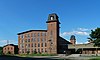
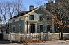
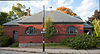
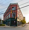
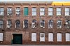
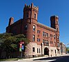
This is a list of the National Register of Historic Places listings in Providence County, Rhode Island.

<span class="mw-page-title-main">National Register of Historic Places listings in Washington County, Rhode Island</span>

This is a list of the National Register of Historic Places listings in Washington County, Rhode Island.

<span class="mw-page-title-main">National Register of Historic Places listings in Providence, Rhode Island</span>

This is a list of the National Register of Historic Places listings in Providence, Rhode Island.

This is intended to be a complete list of properties and districts listed on the National Register of Historic Places on Manhattan Island below 14th Street, which is a significant portion of the New York City borough of Manhattan. In turn, the borough of Manhattan is coterminous with New York County, New York. For properties and districts in other parts of Manhattan Island, the mainland neighborhood of Marble Hill, and the other islands of New York County, see National Register of Historic Places listings in Manhattan. The locations of National Register properties and districts may be seen in an online map by clicking on "Map of all coordinates".

This is intended to be a complete list of properties and districts listed on the National Register of Historic Places on Manhattan Island, the primary portion of the New York City borough of Manhattan, from 14th to 59th Streets. For properties and districts in other parts of Manhattan, whether on Manhattan Island, other islands within the borough, or the neighborhood of Marble Hill on the North American mainland, see National Register of Historic Places listings in Manhattan. The locations of National Register properties and districts may be seen in an online map by clicking on "Map of all coordinates".

This is intended to be a complete list of historic properties and districts listed on the National Register of Historic Places located on islands other than Manhattan Island but still in New York County, New York. For all properties and districts in the borough of Manhattan, see National Register of Historic Places listings in New York County, New York. The locations of National Register properties and districts may be seen in an online map by clicking on "Map of all coordinates".

<span class="mw-page-title-main">National Register of Historic Places listings in Charles City County, Virginia</span>

This is a list of the National Register of Historic Places listings in Charles City County, Virginia.

<span class="mw-page-title-main">National Register of Historic Places listings in Clinton County, Iowa</span>

This is a list of the National Register of Historic Places listings in Clinton County, Iowa.

<span class="mw-page-title-main">National Register of Historic Places listings in Rock Island County, Illinois</span>

This is a list of the National Register of Historic Places listings in Rock Island County, Illinois.

References

  1. The latitude and longitude information provided in this table was derived originally from the National Register Information System, which has been found to be fairly accurate for about 99% of listings. Some locations in this table may have been corrected to current GPS standards.
  2. National Park Service, United States Department of the Interior, "National Register of Historic Places: Weekly List Actions", retrieved February 9, 2024.
  3. Numbers represent an alphabetical ordering by significant words. Various colorings, defined here, differentiate National Historic Landmarks and historic districts from other NRHP buildings, structures, sites or objects.
  4. "National Register Information System". National Register of Historic Places . National Park Service. March 13, 2009.
  5. The eight-digit number below each date is the number assigned to each location in the National Register Information System database, which can be viewed by clicking the number.