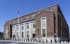
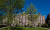
[3] Name on the Register [4] Image Date listed [5] Location Description 1 Nelson W. Aldrich House Nelson W. Aldrich House December 8, 1976 (# 76000040 110 Benevolent St. 41°49′30″N 71°23′46″W / 41.825°N 71.396111°W / 41.825; -71.396111 (Nelson W. Aldrich House ) Home of Aldrich , a longtime U.S. Senator. Today home of the Rhode Island Historical Society 2 All Saints Memorial Church All Saints Memorial Church January 7, 1980 (# 80000083 674 Westminster St. 41°49′05″N 71°25′09″W / 41.818056°N 71.419167°W / 41.818056; -71.419167 (All Saints Memorial Church ) A significant work of architect Edward Tuckerman Potter . 3 Candace Allen House Candace Allen House April 11, 1973 (# 73000062 12 Benevolent St. 41°49′29″N 71°24′15″W / 41.824834°N 71.404272°W / 41.824834; -71.404272 (Candace Allen House ) An exemplar of the domestic architectural taste of wealthy Providence families in the 1820s 4 Zachariah Allen House Zachariah Allen House September 15, 1994 (# 94001152 1093 Smith St. 41°50′39″N 71°26′56″W / 41.844167°N 71.448889°W / 41.844167; -71.448889 (Zachariah Allen House ) A well-preserved example of a transitional Georgian -Federal style house 5 America Street School America Street School June 18, 1987 (# 87000996 22 America St. 41°49′23″N 71°25′42″W / 41.823056°N 71.428333°W / 41.823056; -71.428333 (America Street School ) Demolished 1996. [6] 6 American Brewing Company Plant American Brewing Company Plant June 21, 2016 (# 16000395 431 Harris Ave. 41°49′29″N 71°26′05″W / 41.824841°N 71.434690°W / 41.824841; -71.434690 (American Brewing Company Plant ) A well-preserved example of a state of the art late 19th century brewery facility 7 Andrew Dickhaut Cottages Historic District Andrew Dickhaut Cottages Historic District February 23, 1984 (# 84001904 114–141 Bath St., 6-18 Duke St., and 377 Orms St. 41°50′00″N 71°25′33″W / 41.833333°N 71.425833°W / 41.833333; -71.425833 (Andrew Dickhaut Cottages Historic District ) A discrete and intact collection of late 19th-century workers' housing 8 The Arcade The Arcade May 6, 1971 (# 71000029 130 Westminster St. and 65 Weybosset St. 41°49′25″N 71°24′39″W / 41.823611°N 71.410833°W / 41.823611; -71.410833 (The Arcade ) First enclosed shopping mall in the United States, built 1828 9 Arnold-Palmer House Arnold-Palmer House January 20, 1972 (# 72000034 33 Chestnut St. 41°49′09″N 71°24′50″W / 41.819167°N 71.413889°W / 41.819167; -71.413889 (Arnold-Palmer House ) A well-preserved and fine example of late Federal architecture 10 Aylesworth Apartments Aylesworth Apartments November 12, 1982 (# 82000133 188–194 Broad St. 41°49′00″N 71°25′06″W / 41.816587°N 71.418245°W / 41.816587; -71.418245 (Aylesworth Apartments ) Providence's oldest known purpose-built apartments 11 William L. Bailey House William L. Bailey House March 7, 1973 (# 73000064 Eaton St., Providence College campus 41°50′31″N 71°26′07″W / 41.841944°N 71.435278°W / 41.841944; -71.435278 (William L. Bailey House ) Now known as Dominic Hall, the official residence of the Providence College president 12 Beaman and Smith Company Mill Beaman and Smith Company Mill April 20, 2006 (# 06000299 20 Gordon Ave. 41°48′17″N 71°24′57″W / 41.804635°N 71.415926°W / 41.804635; -71.415926 (Beaman and Smith Company Mill ) 13 Bell Street Chapel Bell Street Chapel March 14, 1973 (# 73000065 5 Bell St. 41°49′07″N 71°26′12″W / 41.818611°N 71.436667°W / 41.818611; -71.436667 (Bell Street Chapel ) 14 Beneficent Congregational Church Beneficent Congregational Church January 13, 1972 (# 72000035 300 Weybosset St. 41°49′11″N 71°24′51″W / 41.819722°N 71.414167°W / 41.819722; -71.414167 (Beneficent Congregational Church ) The oldest church in Providence west of the Providence River ] and an outstanding example of Greek Revival architecture 15 Blackstone Boulevard Realty Plat Historic District Blackstone Boulevard Realty Plat Historic District June 9, 1995 (# 95000711 Roughly bounded by Blackstone Boulevard, Rochambeau Ave., Holly St., and Elmgrove Ave. 41°50′54″N 71°23′24″W / 41.848333°N 71.39°W / 41.848333; -71.39 (Blackstone Boulevard Realty Plat Historic District ) 16 Blackstone Boulevard-Cole Avenue-Grotto Avenue Historic District Blackstone Boulevard-Cole Avenue-Grotto Avenue Historic District November 12, 2009 (# 09000363 Roughly bounded by Blackstone Boulevard and Cole, Grotto, President, and Rochambeau Aves. 41°50′27″N 71°23′08″W / 41.840936°N 71.385619°W / 41.840936; -71.385619 (Blackstone Boulevard-Cole Avenue-Grotto Avenue Historic District ) 17 Blackstone Canal Blackstone Canal May 6, 1971 (# 71000030 From Steeple and Promenade Sts. to the Ashton Dam ; also from the Ashton Dam north to the Massachusetts state line 41°55′16″N 71°25′21″W / 41.921111°N 71.4225°W / 41.921111; -71.4225 (Blackstone Canal ) Initial listing extended from Providence, through Pawtucket, and as far north as Lincoln; a November 1, 1991 expansion extended it to the state line; the canal itself extended into Worcester County, Massachusetts , where it is the subject of separate listings. 18 Blackstone Park Historic District Upload image June 5, 1998 (# 98000575 Roughly bounded by the Seekonk River , Laurell Ave., Blackstone Boulevard, and S. Angell St. 41°50′02″N 71°22′56″W / 41.833889°N 71.382222°W / 41.833889; -71.382222 (Blackstone Park Historic District ) 19 Charles Brackett House Charles Brackett House April 3, 1970 (# 70000018 45 Prospect St. 41°49′39″N 71°24′18″W / 41.8275°N 71.405°W / 41.8275; -71.405 (Charles Brackett House ) Built in 1875 by George Henry Corliss , this house is a large and monumental example of the Italian Villa style 20 George M. Bradley House George M. Bradley House January 13, 1972 (# 72000037 Eaton St., Providence College campus 41°50′31″N 71°26′14″W / 41.841944°N 71.437222°W / 41.841944; -71.437222 (George M. Bradley House ) 21 William J. Braitsch and Company Plant William J. Braitsch and Company Plant July 11, 2016 (# 16000443 472 Potters Ave. 41°48′05″N 71°25′28″W / 41.801489°N 71.424389°W / 41.801489; -71.424389 (William J. Braitsch and Company Plant ) 22 Brick Schoolhouse Brick Schoolhouse December 5, 1972 (# 72000038 24 Meeting St. 41°49′43″N 71°24′34″W / 41.828611°N 71.409444°W / 41.828611; -71.409444 (Brick Schoolhouse ) Home of one of the first free schools in the United States and the first brick schoolhouse in the city of Providence 23 Bridgham-Arch-Wilson Streets Historic District Bridgham-Arch-Wilson Streets Historic District September 1, 1988 (# 88001433 Roughly bounded by Lester and Bridgham Sts., Elmwood Ave., and Warren and Dexter Sts. 41°48′43″N 71°25′36″W / 41.811944°N 71.426667°W / 41.811944; -71.426667 (Bridgham-Arch-Wilson Streets Historic District ) 24 Broadway-Armory Historic District Broadway-Armory Historic District May 1, 1974 (# 74000047 Providence; specifically 144-146, 148, 150, and 156-158 Broadway and 226 and 230 Dean St. 41°48′58″N 71°25′46″W / 41.816111°N 71.429444°W / 41.816111; -71.429444 (Broadway-Armory Historic District ) Specific boundaries represent a boundary increase of January 2, 2008 25 Brown and Sharpe Manufacturing Company Complex Brown and Sharpe Manufacturing Company Complex April 18, 2003 (# 03000081 Promenade, Bath, Calverly, West Park, Holden, and Brownell Sts, and Interstate 95 41°49′48″N 71°25′15″W / 41.83°N 71.420833°W / 41.83; -71.420833 (Brown and Sharpe Manufacturing Company Complex ) 26 John Brown House John Brown House November 24, 1968 (# 68000007 52 Power St. 41°49′22″N 71°24′16″W / 41.822778°N 71.404444°W / 41.822778; -71.404444 (John Brown House ) Late Georgian house of early benefactor of Brown University; one of the first large houses built in Providence's post-Revolutionary expansion 27 Morris Brown House Morris Brown House August 22, 1991 (# 91001025 317 Rochambeau Ave. 41°50′48″N 71°23′39″W / 41.846667°N 71.394167°W / 41.846667; -71.394167 (Morris Brown House ) 28 Moses Brown School Moses Brown School July 24, 1980 (# 80000088 250 Lloyd Ave. 41°50′00″N 71°23′56″W / 41.833333°N 71.398889°W / 41.833333; -71.398889 (Moses Brown School ) 29 Burrows Block Burrows Block September 5, 1990 (# 90001347 735–745 Westminster St. 41°49′05″N 71°25′15″W / 41.818056°N 71.420833°W / 41.818056; -71.420833 (Burrows Block ) 30 Butler Hospital Butler Hospital October 8, 1976 (# 76000041 345 Blackstone Boulevard 41°50′35″N 71°22′54″W / 41.843056°N 71.381667°W / 41.843056; -71.381667 (Butler Hospital ) 31 Calvary Baptist Church Calvary Baptist Church January 7, 1980 (# 80000089 747 Broad St. 41°48′13″N 71°24′29″W / 41.803611°N 71.408056°W / 41.803611; -71.408056 (Calvary Baptist Church ) 32 A. F. Cappelli Block A. F. Cappelli Block March 3, 1980 (# 80000090 263–265 Atwells Ave. 41°49′24″N 71°25′38″W / 41.823333°N 71.427222°W / 41.823333; -71.427222 (A. F. Cappelli Block ) Exemplary of mixed-use commercial blocks constructed at the turn of the century 33 Dr. George W. Carr House Dr. George W. Carr House March 7, 1973 (# 73000067 29 Waterman St. 41°49′36″N 71°24′31″W / 41.826667°N 71.408611°W / 41.826667; -71.408611 (Dr. George W. Carr House ) 34 Cathedral of Saints Peter and Paul Cathedral of Saints Peter and Paul February 10, 1975 (# 75000057 Cathedral Sq. 41°49′09″N 71°25′01″W / 41.819167°N 71.416944°W / 41.819167; -71.416944 (Cathedral of Saints Peter and Paul ) 35 Central Diner Central Diner January 13, 2010 (# 09001231 777 Elmwood Ave. 41°47′28″N 71°25′21″W / 41.791031°N 71.422558°W / 41.791031; -71.422558 (Central Diner ) 36 Chemical Building, Fields Point Sewage Treatment Plant Chemical Building, Fields Point Sewage Treatment Plant January 13, 1989 (# 88003106 Ernest St. at Fields Point 41°47′40″N 71°23′26″W / 41.794444°N 71.390556°W / 41.794444; -71.390556 (Chemical Building, Fields Point Sewage Treatment Plant ) 37 Christ Episcopal Church Christ Episcopal Church June 30, 1976 (# 76000043 909 Eddy St. 41°48′09″N 71°24′27″W / 41.8025°N 71.4075°W / 41.8025; -71.4075 (Christ Episcopal Church ) Demolished in 2006 38 College Hill Historic District College Hill Historic District November 10, 1970 (# 70000019 Roughly bounded by the Providence and Seekonk Rivers, Olney, Hope, and Governor Sts., Carrington and Whittier 41°49′35″N 71°24′12″W / 41.826389°N 71.403333°W / 41.826389; -71.403333 (College Hill Historic District ) Original 120 acres (0.49 km2 ) of city of Providence, laid out by Roger Williams . Contains many well-preserved 18th- and 19th-century buildings and homes as well as Brown and the Rhode Island School of Design 39 Columbus Columbus October 19, 2001 (# 01000468 Columbus Square, at Elmwood Ave. and Reservoir Ave. 41°47′48″N 71°25′33″W / 41.79679°N 71.42577°W / 41.79679; -71.42577 (Columbus Removed in June 2020 [7] 40 Congdon Street Baptist Church Congdon Street Baptist Church June 21, 1971 (# 71000032 17 Congdon St. 41°49′42″N 71°24′25″W / 41.828333°N 71.406944°W / 41.828333; -71.406944 (Congdon Street Baptist Church ) 41 John Corliss House John Corliss House May 1, 1974 (# 74000049 201 S. Main St. 41°49′23″N 71°24′24″W / 41.823056°N 71.406667°W / 41.823056; -71.406667 (John Corliss House ) A rare survivor of a major 1801 fire and one of only a few remaining houses in the area constructed prior to the American Revolution 42 Corliss-Carrington House Corliss-Carrington House December 30, 1970 (# 70000020 66 Williams St. 41°49′21″N 71°24′09″W / 41.8225°N 71.4025°W / 41.8225; -71.4025 (Corliss-Carrington House ) Well-preserved Adamesque -Federal style townhouse from 1812, with wrought iron columns on front facade 43 Covell Street School Covell Street School September 30, 1976 (# 76000044 231 Amherst St. 41°49′24″N 71°26′51″W / 41.8233°N 71.4474°W / 41.8233; -71.4474 (Covell Street School ) 44 Customhouse Historic District Customhouse Historic District February 20, 1975 (# 75000058 Bounded by Westminster, Exchange, Dyer, Pine, and Peck Sts. 41°49′26″N 71°24′36″W / 41.823889°N 71.41°W / 41.823889; -71.41 (Customhouse Historic District ) 45 Susan S. & Edward J. Cutler House Susan S. & Edward J. Cutler House April 6, 2015 (# 15000138 12 Woodbine St. 41°50′45″N 71°24′18″W / 41.8458°N 71.405°W / 41.8458; -71.405 (Susan S. & Edward J. Cutler House ) 46 Davol Rubber Company Davol Rubber Company June 27, 1980 (# 80000093 Point and Eddy Sts. 41°49′02″N 71°24′25″W / 41.817222°N 71.406944°W / 41.817222; -71.406944 (Davol Rubber Company ) 47 Richard Henry Deming House Richard Henry Deming House January 7, 1980 (# 80000094 66 Burnett St. 41°48′09″N 71°25′38″W / 41.8025°N 71.427222°W / 41.8025; -71.427222 (Richard Henry Deming House ) 48 Edward Dexter House Edward Dexter House June 21, 1971 (# 71000033 72 Waterman St. 41°49′37″N 71°24′15″W / 41.826944°N 71.404167°W / 41.826944; -71.404167 (Edward Dexter House ) 49 Jeremiah Dexter House Jeremiah Dexter House October 8, 1976 (# 76000046 957 N. Main St. 41°50′48″N 71°24′19″W / 41.846667°N 71.405278°W / 41.846667; -71.405278 (Jeremiah Dexter House ) 50 Charles Dowler House Charles Dowler House February 23, 1984 (# 84001955 581 Smith St. 41°50′09″N 71°25′51″W / 41.835833°N 71.430833°W / 41.835833; -71.430833 (Charles Dowler House ) 51 Downtown Providence Historic District Downtown Providence Historic District February 10, 1984 (# 84001967 Roughly bounded by Washington, Westminster, Empire, and Weybosset Sts.; also along Friendship, Pine, and Richmond Sts.; also 250 and 254 Washington Sts. 41°49′24″N 71°24′48″W / 41.823333°N 71.413333°W / 41.823333; -71.413333 (Downtown Providence Historic District ) Second and third sets of locations represent boundary increases of October 11, 2007 and July 25, 2012 52 Doyle Avenue Historic District Doyle Avenue Historic District February 22, 1990 (# 90000104 Doyle Ave. from N. Main St. to Hope St. 41°50′19″N 71°24′26″W / 41.838611°N 71.407222°W / 41.838611; -71.407222 (Doyle Avenue Historic District ) 53 Dyerville Mill Dyerville Mill June 18, 1979 (# 79000055 610 Manton Ave. 41°49′35″N 71°27′42″W / 41.826389°N 71.461667°W / 41.826389; -71.461667 (Dyerville Mill ) 54 Earnscliffe Woolen-Paragon Worsted Company Mill Complex Earnscliffe Woolen-Paragon Worsted Company Mill Complex April 4, 2007 (# 07000265 25 and 39 Manton Ave. 41°49′05″N 71°26′39″W / 41.818056°N 71.444167°W / 41.818056; -71.444167 (Earnscliffe Woolen-Paragon Worsted Company Mill Complex ) 55 Elizabeth Building Elizabeth Building November 5, 1971 (# 71000034 100 N. Main St. 41°49′41″N 71°24′38″W / 41.828056°N 71.410556°W / 41.828056; -71.410556 (Elizabeth Building ) One of Providence's few surviving commercial buildings with a cast iron facade 56 Elmgrove Gardens Historic District Elmgrove Gardens Historic District February 2, 2005 (# 04001589 Rochambeau, Morris, and Cole Aves. and Fosdyke and Woodbury Sts. 41°50′52″N 71°23′31″W / 41.847778°N 71.391944°W / 41.847778; -71.391944 (Elmgrove Gardens Historic District ) 57 Elmwood Historic District Elmwood Historic District January 7, 1980 (# 80004603 North Section bounded by Broad Street and Elmwood Avenue, along sections of Whitmarsh, Moore, Daboll, and Mawney Sts. and Princeton Ave. South Section along Ontario St. and Congress, Lexington, Atlantic, and Adelaide Aves. [8] 41°48′03″N 71°25′23″W / 41.800833°N 71.423056°W / 41.800833; -71.423056 (Elmwood Historic District ) 58 Ernest Street Sewage Pumping Station Ernest Street Sewage Pumping Station January 13, 1989 (# 88003103 Ernest and Ellis Sts. 41°47′42″N 71°23′52″W / 41.795°N 71.397778°W / 41.795; -71.397778 (Ernest Street Sewage Pumping Station ) 59 Federal Building Federal Building April 13, 1972 (# 72000040 Kennedy Plaza 41°49′33″N 71°24′40″W / 41.825833°N 71.411111°W / 41.825833; -71.411111 (Federal Building ) 60 First Baptist Meetinghouse First Baptist Meetinghouse October 15, 1966 (# 66000017 N. Main St. between Thomas and Waterman Sts. 41°49′38″N 71°24′33″W / 41.827222°N 71.409167°W / 41.827222; -71.409167 (First Baptist Meetinghouse ) Oldest Baptist church congregation in U.S., founded by Roger Williams in 1638; the present Joseph Brown building dates to 1775. 61 First Universalist Church First Universalist Church August 16, 1977 (# 77000026 250 Washington St. 41°49′15″N 71°25′04″W / 41.820833°N 71.417778°W / 41.820833; -71.417778 (First Universalist Church ) 62 Fleur-de-Lys Studios Fleur-de-Lys Studios October 5, 1992 (# 92001886 7 Thomas St. 41°49′40″N 71°24′33″W / 41.827778°N 71.409167°W / 41.827778; -71.409167 (Fleur-de-Lys Studios ) 63 Freeman Plat Historic District Freeman Plat Historic District June 2, 1995 (# 95000664 Roughly bounded by Morris, Sessions, Cole, and Everett Aves. 41°50′18″N 71°23′38″W / 41.838333°N 71.393889°W / 41.838333; -71.393889 (Freeman Plat Historic District ) 64 General Ice Cream Corporation Building General Ice Cream Corporation Building August 19, 2008 (# 08000788 485 Plainfield St. 41°48′49″N 71°27′16″W / 41.813622°N 71.454567°W / 41.813622; -71.454567 (General Ice Cream Corporation Building ) 65 Gloria Dei Evangelical Lutheran Church Gloria Dei Evangelical Lutheran Church February 23, 1984 (# 84002006 15 Hayes St. 41°49′46″N 71°25′03″W / 41.829444°N 71.4175°W / 41.829444; -71.4175 (Gloria Dei Evangelical Lutheran Church ) 66 Grace Church Grace Church June 19, 1972 (# 72000042 175 Mathewson St. 41°49′18″N 71°24′50″W / 41.821667°N 71.413889°W / 41.821667; -71.413889 (Grace Church ) 67 Joseph Haile House Joseph Haile House May 19, 1972 (# 72000007 106 George St. 41°49′32″N 71°24′10″W / 41.825556°N 71.402778°W / 41.825556; -71.402778 (Joseph Haile House ) A free-standing 1806 townhouse restored extensively in the 1930s to house a collection of furniture and paitnings 68 Hay and Owen Buildings Hay and Owen Buildings November 12, 1982 (# 82001859 101 and 117–135 Dyer St. 41°49′24″N 71°24′33″W / 41.823333°N 71.409167°W / 41.823333; -71.409167 (Hay and Owen Buildings ) 69 Heaton and Cowing Mill Heaton and Cowing Mill June 6, 2012 (# 12000332 1115 Douglas Ave. 41°51′26″N 71°26′34″W / 41.85724°N 71.442765°W / 41.85724; -71.442765 (Heaton and Cowing Mill ) 70 Hope Block and Cheapside Hope Block and Cheapside May 21, 1975 (# 75000059 22–26 and 40 N. Main St. 41°49′35″N 71°24′33″W / 41.826389°N 71.409167°W / 41.826389; -71.409167 (Hope Block and Cheapside ) 71 Hope-Power-Cooke Streets Historic District Hope-Power-Cooke Streets Historic District January 12, 1973 (# 73000070 Roughly bounded by Angell, Governor, Williams, and Brook Sts. 41°49′35″N 71°23′51″W / 41.826389°N 71.3975°W / 41.826389; -71.3975 (Hope-Power-Cooke Streets Historic District ) 72 Esek Hopkins House Esek Hopkins House May 22, 1973 (# 73000071 97 Admiral St. 41°50′29″N 71°25′15″W / 41.841389°N 71.420833°W / 41.841389; -71.420833 (Esek Hopkins House ) 73 Gov. Stephen Hopkins House Gov. Stephen Hopkins House April 3, 1970 (# 70000022 15 Hopkins St. 41°49′29″N 71°24′25″W / 41.824722°N 71.406944°W / 41.824722; -71.406944 (Gov. Stephen Hopkins House ) Home of colonial and state governor and signer of the Declaration of Independence 74 Thomas F. Hoppin House Thomas F. Hoppin House February 6, 1973 (# 73000072 383 Benefit St. 41°49′17″N 71°24′11″W / 41.821389°N 71.403056°W / 41.821389; -71.403056 (Thomas F. Hoppin House ) Home to the Annenberg Institute for School Reform at Brown University 75 Thomas P. Ives House Thomas P. Ives House December 30, 1970 (# 70000023 66 Power St. 41°49′24″N 71°24′10″W / 41.823333°N 71.402778°W / 41.823333; -71.402778 (Thomas P. Ives House ) 76 Jones Warehouses Jones Warehouses January 7, 1980 (# 80000099 49–63 Central St. 41°48′50″N 71°25′23″W / 41.813949°N 71.423118°W / 41.813949; -71.423118 (Jones Warehouses ) 77 Ladd Observatory Ladd Observatory June 6, 2000 (# 93000583 210 Doyle Ave., at its junction with Hope St. 41°50′21″N 71°23′59″W / 41.839167°N 71.399722°W / 41.839167; -71.399722 (Ladd Observatory ) A significant work of locally eminent firm Stone, Carpenter & Willson 78 Governor Henry Lippitt House Governor Henry Lippitt House November 27, 1972 (# 72000043 199 Hope St. 41°49′41″N 71°23′52″W / 41.828056°N 71.397778°W / 41.828056; -71.397778 (Governor Henry Lippitt House ) Italian villa home by Henry Childs with many original interiors 79 Loew's State Theater Loew's State Theater August 19, 1977 (# 77000027 220 Weybosset St. 41°49′15″N 71°24′45″W / 41.820833°N 71.4125°W / 41.820833; -71.4125 (Loew's State Theater ) Now known as the Providence Performing Arts Center 80 Louttit Laundry Louttit Laundry March 18, 2004 (# 04000197 93 Cranston St. 41°49′04″N 71°25′27″W / 41.817778°N 71.424167°W / 41.817778; -71.424167 (Louttit Laundry ) Demolished 2008 [9] 81 Matthew Lynch House Matthew Lynch House March 8, 1978 (# 78000001 120 Robinson St. 41°48′29″N 71°25′01″W / 41.808116°N 71.416985°W / 41.808116; -71.416985 (Matthew Lynch House ) 82 Market House Market House April 13, 1972 (# 72000001 Market Sq. 41°49′32″N 71°24′31″W / 41.825556°N 71.408611°W / 41.825556; -71.408611 (Market House ) 83 Israel B. Mason House Israel B. Mason House August 16, 1977 (# 77000001 571 Broad St. 41°48′31″N 71°25′16″W / 41.808701°N 71.421039°W / 41.808701; -71.421039 (Israel B. Mason House ) 84 Mechanical Fabric Company Mechanical Fabric Company January 8, 2014 (# 13001059 55 Cromwell St., 40, 40R, 50, and 50R Sprague St. 41°48′33″N 71°25′35″W / 41.809278°N 71.426407°W / 41.809278; -71.426407 (Mechanical Fabric Company ) 85 Merchants Bank Building Merchants Bank Building November 21, 1977 (# 77000002 32 Westminster St. 41°49′29″N 71°24′36″W / 41.824722°N 71.41°W / 41.824722; -71.41 (Merchants Bank Building ) 86 Moshassuck Square Moshassuck Square September 8, 1970 (# 70000001 Roughly bounded by Charles, Randall, N. Main, and Smith Sts. 41°50′03″N 71°24′43″W / 41.834167°N 71.411944°W / 41.834167; -71.411944 (Moshassuck Square ) 87 National and Providence Worsted Mills National and Providence Worsted Mills July 11, 2003 (# 03000656 166 Valley St. 41°49′16″N 71°26′27″W / 41.821051°N 71.440957°W / 41.821051; -71.440957 (National and Providence Worsted Mills ) 88 New England Butt Company New England Butt Company January 7, 1980 (# 80000001 304 Pearl St. 41°48′54″N 71°25′22″W / 41.815°N 71.422778°W / 41.815; -71.422778 (New England Butt Company ) 89 Nicholson File Company Mill Complex Nicholson File Company Mill Complex August 22, 2005 (# 05000918 1–45 Acorn St. 41°49′39″N 71°25′47″W / 41.8275°N 71.429722°W / 41.8275; -71.429722 (Nicholson File Company Mill Complex ) 90 Nightingale-Brown House Nightingale-Brown House June 29, 1989 (# 89001242 357 Benefit St. 41°49′16″N 71°24′09″W / 41.821111°N 71.4025°W / 41.821111; -71.4025 (Nightingale-Brown House ) One of the most accomplished Georgian homes in the country; later renovations and additions by Richard Upjohn and grounds by Frederick Law Olmsted 91 North Burial Ground North Burial Ground September 13, 1977 (# 77000003 Between Branch Ave. and N. Main St. 41°50′55″N 71°24′24″W / 41.848611°N 71.406667°W / 41.848611; -71.406667 (North Burial Ground ) 92 Norwood Avenue Historic District Norwood Avenue Historic District April 26, 2002 (# 02000412 Roughly along Norwood Ave. between Roger Williams Park and Broad St. 41°46′51″N 71°24′12″W / 41.780833°N 71.403333°W / 41.780833; -71.403333 (Norwood Avenue Historic District ) Extends into Cranston 93 Oakland Avenue Historic District Oakland Avenue Historic District November 1, 1984 (# 84000378 Roughly bounded by Pembroke Ave. and Eaton, Malbone, and Dickens Sts. 41°50′20″N 71°25′48″W / 41.838889°N 71.43°W / 41.838889; -71.43 (Oakland Avenue Historic District ) 94 Olney Street-Alumni Avenue Historic District Olney Street-Alumni Avenue Historic District May 11, 1989 (# 89000333 Roughly bounded by Olney St., Arlington Ave., Alumni Ave., and Hope St. 41°50′09″N 71°23′53″W / 41.835725°N 71.398019°W / 41.835725; -71.398019 (Olney Street-Alumni Avenue Historic District ) 95 Ontario Apartments Ontario Apartments March 5, 1998 (# 98000214 25–31 and 37–41 Ontario St. 41°48′00″N 71°25′11″W / 41.8°N 71.419722°W / 41.8; -71.419722 (Ontario Apartments ) 96 Oriental Mills Oriental Mills December 23, 2005 (# 05001463 10 Admiral St. 41°50′23″N 71°25′10″W / 41.839722°N 71.419444°W / 41.839722; -71.419444 (Oriental Mills ) 97 Our Lady of Lourdes Church Complex Our Lady of Lourdes Church Complex March 15, 1990 (# 90000343 901–903 Atwells Ave. 41°49′32″N 71°26′52″W / 41.825556°N 71.447778°W / 41.825556; -71.447778 (Our Lady of Lourdes Church Complex ) 98 Parkis-Comstock Historic District Parkis-Comstock Historic District January 7, 1980 (# 80000005 Broad St. and Parkis and Comstock Aves.; also 568 and 570-572 Broad St. and 39-41, 54-56, and 60-62 Harvard Ave. 41°48′33″N 71°25′15″W / 41.809294°N 71.420891°W / 41.809294; -71.420891 (Parkis-Comstock Historic District ) Specific addresses represent a boundary increase of May 5, 1988 99 Nathaniel Pearce House Nathaniel Pearce House May 19, 1972 (# 72000002 305 Brook St. 41°49′31″N 71°23′56″W / 41.825312°N 71.398777°W / 41.825312; -71.398777 (Nathaniel Pearce House ) 100 Pekin Street Historic District Pekin Street Historic District November 1, 1984 (# 84000381 Roughly bounded by Pekin and Candace Sts., Douglas and Chalkstone Aves. 41°50′12″N 71°25′29″W / 41.836667°N 71.424722°W / 41.836667; -71.424722 (Pekin Street Historic District ) 101 Perkins Buildings Perkins Buildings January 30, 2004 (# 03001521 85 Sprague St., 101 and 102 Westfield St. 41°48′37″N 71°25′40″W / 41.8103°N 71.4278°W / 41.8103; -71.4278 (Perkins Buildings ) 102 Pine Street Historic District Pine Street Historic District September 13, 1978 (# 78000005 Irregular pattern along Pine St. from Myrtle to Seekill Sts. 41°48′50″N 71°25′06″W / 41.8139°N 71.4183°W / 41.8139; -71.4183 (Pine Street Historic District ) 103 Plain Farm House Plain Farm House June 27, 1980 (# 80000006 108 Webster Ave. 41°48′48″N 71°27′01″W / 41.8134°N 71.4504°W / 41.8134; -71.4504 (Plain Farm House ) 104 Plymouth Congregational Church Plymouth Congregational Church March 12, 2021 (# 100006299 1014 Broad St. 41°47′50″N 71°24′48″W / 41.7973°N 71.4134°W / 41.7973; -71.4134 (Plymouth Congregational Church ) 104 Poirier's Diner Poirier's Diner July 17, 2003 (# 03000657 1380 Westminster St. 41°49′07″N 71°26′01″W / 41.818611°N 71.433611°W / 41.818611; -71.433611 (Poirier's Diner ) Originally located at 1467 Westminster St.; moved to 1380 Westminster Street in 2011. Operating as "West Side Diner." 105 Power Street-Cooke Street Historic District Upload image July 30, 1974 (# 74002345 Roughly bounded by Angell, Governor, Power, and Hope Sts. 41°49′33″N 71°23′47″W / 41.825833°N 71.396389°W / 41.825833; -71.396389 (Power Street-Cooke Street Historic District ) 106 Providence City Hall Providence City Hall January 23, 1975 (# 75000001 Dorrance and Washington Sts. 41°49′26″N 71°24′48″W / 41.823889°N 71.413333°W / 41.823889; -71.413333 (Providence City Hall ) 107 Providence Dyeing, Bleaching, Calendring Company Providence Dyeing, Bleaching, Calendring Company October 18, 2004 (# 04000809 46, 50, 52, and 60 Valley St. and 80 Delaine St. 41°49′07″N 71°26′31″W / 41.818611°N 71.441944°W / 41.818611; -71.441944 (Providence Dyeing, Bleaching, Calendring Company ) 108 Providence Fruit and Produce Warehouse Company Building Providence Fruit and Produce Warehouse Company Building June 10, 2005 (# 05000583 6–64 Harris Ave. 41°49′40″N 71°25′49″W / 41.827778°N 71.430278°W / 41.827778; -71.430278 (Providence Fruit and Produce Warehouse Company Building ) Demolished in January 2008. 109 Providence Gas Company Purifier House Providence Gas Company Purifier House June 21, 2007 (# 07000589 200 Allens Ave. 41°48′29″N 71°24′11″W / 41.808185°N 71.403160°W / 41.808185; -71.403160 (Providence Gas Company Purifier House ) 110 Providence Jewelry Manufacturing Historic District Providence Jewelry Manufacturing Historic District December 5, 1985 (# 85003088 Bounded by Ship St., Ashcroft and Elbow and Hospital Sts., Point and South Sts., Imperial and Claverick Sts., and U.S. Route 195 ; also bounded by U.S. Route 195 and Point, Parsonage, South, Hospital, Elbow, Ashcroft, Richmond, Eddy, and Ship Sts. 41°49′02″N 71°24′39″W / 41.817222°N 71.410833°W / 41.817222; -71.410833 (Providence Jewelry Manufacturing Historic District ) Second set of boundaries represents a boundary increase of March 20, 2012 111 Providence Lying-In Hospital Providence Lying-In Hospital August 13, 1986 (# 86001512 50 Maude St. 41°50′08″N 71°25′47″W / 41.835556°N 71.429722°W / 41.835556; -71.429722 (Providence Lying-In Hospital ) 112 Providence Steel and Iron Company Complex Providence Steel and Iron Company Complex August 24, 2005 (# 05000919 27 Sims Ave. 41°49′34″N 71°26′05″W / 41.826111°N 71.434722°W / 41.826111; -71.434722 (Providence Steel and Iron Company Complex ) 113 Providence Telephone Company Providence Telephone Company August 4, 1983 (# 83000002 112 Union St. 41°49′19″N 71°24′53″W / 41.821944°N 71.414722°W / 41.821944; -71.414722 (Providence Telephone Company ) 114 Providence-Biltmore Hotel Providence-Biltmore Hotel May 27, 1977 (# 77000005 11 Dorrance St. 41°49′27″N 71°24′49″W / 41.824167°N 71.413611°W / 41.824167; -71.413611 (Providence-Biltmore Hotel ) 115 Reservoir Avenue Sewage Pumping Station Reservoir Avenue Sewage Pumping Station January 13, 1989 (# 88003108 Reservoir and Pontiac Aves. 41°47′15″N 71°25′56″W / 41.7875°N 71.432222°W / 41.7875; -71.432222 (Reservoir Avenue Sewage Pumping Station ) 116 Return Sludge Pumping Station, Fields Point Sewage Treatment Plant Return Sludge Pumping Station, Fields Point Sewage Treatment Plant January 13, 1989 (# 88003105 Ernest St. 41°47′40″N 71°23′18″W / 41.794444°N 71.388333°W / 41.794444; -71.388333 (Return Sludge Pumping Station, Fields Point Sewage Treatment Plant ) 117 Rhode Island Hospital Trust Building Rhode Island Hospital Trust Building October 22, 1976 (# 76000002 15 Westminster St. 41°49′31″N 71°24′37″W / 41.825278°N 71.410278°W / 41.825278; -71.410278 (Rhode Island Hospital Trust Building ) 118 Rhode Island Medical Society Building Rhode Island Medical Society Building June 4, 1984 (# 84002043 106 Francis St. 41°49′46″N 71°25′00″W / 41.829444°N 71.416667°W / 41.829444; -71.416667 (Rhode Island Medical Society Building ) 119 Rhode Island Statehouse Rhode Island Statehouse April 28, 1970 (# 70000002 90 Smith St. 41°49′48″N 71°24′55″W / 41.83°N 71.415278°W / 41.83; -71.415278 (Rhode Island Statehouse ) 120 Rhode Island Tool Company Rhode Island Tool Company August 4, 2004 (# 04000808 146–148 W. River St. 41°50′36″N 71°24′56″W / 41.843333°N 71.415556°W / 41.843333; -71.415556 (Rhode Island Tool Company ) 121 Rhodes Street Historic District Rhodes Street Historic District November 12, 1982 (# 82000004 Rhodes, Janes, and Alphonso Sts. 41°48′28″N 71°24′32″W / 41.807778°N 71.408889°W / 41.807778; -71.408889 (Rhodes Street Historic District ) 122 Rochambeau Branch-Providence Public Library Rochambeau Branch-Providence Public Library March 5, 1998 (# 98000215 708 Hope St. 41°50′46″N 71°23′50″W / 41.846111°N 71.397222°W / 41.846111; -71.397222 (Rochambeau Branch-Providence Public Library ) 123 Rochambeau Worsted Company Mill Rochambeau Worsted Company Mill July 24, 2017 (# 100001366 60 King St. 41°49′23″N 71°27′13″W / 41.823171°N 71.453567°W / 41.823171; -71.453567 (Rochambeau Worsted Company Mill ) 124 Roger Williams National Memorial Roger Williams National Memorial October 15, 1966 (# 66000942 Bounded by N. Main, Canal, Smith, and Haymarket Sts. 41°49′48″N 71°24′38″W / 41.830053°N 71.410547°W / 41.830053; -71.410547 (Roger Williams National Memorial ) 125 Roger Williams Park Historic District Roger Williams Park Historic District October 15, 1966 (# 66000002 Roger Williams Park 41°46′55″N 71°24′43″W / 41.781944°N 71.411944°W / 41.781944; -71.411944 (Roger Williams Park Historic District ) 126 Joseph and William Russell House Joseph and William Russell House August 12, 1971 (# 71000001 118 N. Main St. 41°49′41″N 71°24′34″W / 41.828192°N 71.409575°W / 41.828192; -71.409575 (Joseph and William Russell House ) 127 St. Joseph's Roman Catholic Church St. Joseph's Roman Catholic Church July 15, 1974 (# 74000004 86 Hope St. 41°49′17″N 71°23′50″W / 41.821389°N 71.397222°W / 41.821389; -71.397222 (St. Joseph's Roman Catholic Church ) 128 Saint Martin's Church Saint Martin's Church May 16, 1996 (# 96000571 50 Orchard Ave. 41°49′55″N 71°23′10″W / 41.831944°N 71.386111°W / 41.831944; -71.386111 (Saint Martin's Church ) 129 St. Michael's Roman Catholic Church, Convent, Rectory, and School St. Michael's Roman Catholic Church, Convent, Rectory, and School March 25, 1977 (# 77000006 251 Oxford St. 41°48′06″N 71°24′52″W / 41.801700°N 71.414424°W / 41.801700; -71.414424 (St. Michael's Roman Catholic Church, Convent, Rectory, and School ) 130 St. Stephen's Church St. Stephen's Church February 6, 1973 (# 73000001 114 George St. 41°49′32″N 71°24′04″W / 41.825675°N 71.401214°W / 41.825675; -71.401214 (St. Stephen's Church ) 131 Shakespeare Hall Shakespeare Hall June 18, 1979 (# 79000002 128 Dorrance St. 41°49′20″N 71°24′36″W / 41.822222°N 71.41°W / 41.822222; -71.41 (Shakespeare Hall ) 132 Shepard Company Building Shepard Company Building August 11, 1976 (# 76000003 259 Westminster Mall, 72–92 Washington St. 41°49′22″N 71°24′51″W / 41.822778°N 71.414167°W / 41.822778; -71.414167 (Shepard Company Building ) 133 Sixth District Courthouse Sixth District Courthouse April 28, 1970 (# 70000092 150 Benefit St. 41°49′44″N 71°24′34″W / 41.828889°N 71.409444°W / 41.828889; -71.409444 (Sixth District Courthouse ) Also known as Old State House 134 Sludge Press House, Fields Point Sewage Treatment Plant Sludge Press House, Fields Point Sewage Treatment Plant January 13, 1989 (# 88003104 Ernest St. at Fields Point 41°47′40″N 71°23′24″W / 41.794444°N 71.39°W / 41.794444; -71.39 (Sludge Press House, Fields Point Sewage Treatment Plant ) 135 Smith Hill Branch-Providence Public Library Smith Hill Branch-Providence Public Library March 5, 1998 (# 98000216 31 Candace St. 41°50′07″N 71°25′21″W / 41.835278°N 71.4225°W / 41.835278; -71.4225 (Smith Hill Branch-Providence Public Library ) 136 Smith Hill Historic District Smith Hill Historic District November 4, 1993 (# 93001183 57–65 Brownell St., 73–114 Holden St., 23–80 Jewett St., 189–240 Smith St., and 10–18 W. Park St. 41°49′55″N 71°25′08″W / 41.831944°N 71.418889°W / 41.831944; -71.418889 (Smith Hill Historic District ) 137 Smith Street Primary School Smith Street Primary School February 23, 1984 (# 84002050 396 Smith St. 41°50′02″N 71°25′30″W / 41.833889°N 71.425°W / 41.833889; -71.425 (Smith Street Primary School ) 138 Sons of Jacob Synagogue Sons of Jacob Synagogue August 24, 1989 (# 89001152 24 Douglas Ave. 41°50′06″N 71°25′02″W / 41.834915°N 71.417212°W / 41.834915; -71.417212 (Sons of Jacob Synagogue ) 139 South Providence Branch-Providence Public Library South Providence Branch-Providence Public Library March 5, 1998 (# 98000218 455 Prairie Ave. 41°48′07″N 71°24′51″W / 41.801944°N 71.414167°W / 41.801944; -71.414167 (South Providence Branch-Providence Public Library ) 140 South Street Station South Street Station June 30, 2006 (# 06000553 360 Eddy St. 41°49′07″N 71°24′24″W / 41.818611°N 71.406667°W / 41.818611; -71.406667 (South Street Station ) 141 David Sprague House David Sprague House May 23, 1978 (# 78000010 7 Harvard Ave. at Taylor St. 41°48′32″N 71°25′06″W / 41.8088°N 71.4182°W / 41.8088; -71.4182 (David Sprague House ) This house was moved from its original location at 263 Public St. 142 State Arsenal State Arsenal April 28, 1970 (# 70000003 176 Benefit St. 41°49′42″N 71°24′32″W / 41.8283°N 71.4089°W / 41.8283; -71.4089 (State Arsenal ) 143 State Home and School for Dependent and Neglected Children State Home and School for Dependent and Neglected Children December 30, 2019 (# 100004820 Rhode Island College , East Campus, 600 Mount Pleasant Ave. 41°50′38″N 71°27′24″W / 41.8438°N 71.4566°W / 41.8438; -71.4566 (State Home and School for Dependent and Neglected Children ) 144 Stedman & Fuller Manufacturing Company Complex Stedman & Fuller Manufacturing Company Complex June 14, 2021 (# 100006644 49 Westfield St. 41°48′37″N 71°25′36″W / 41.8103°N 71.4266°W / 41.8103; -71.4266 (Stedman & Fuller Manufacturing Company Complex ) 144 Stimson Avenue Historic District Stimson Avenue Historic District April 24, 1973 (# 73000003 Both sides of Stimson Ave. and Diman Pl. between Angell St. on the south, Hope St. on the west, and a stone wall on the north 41°49′42″N 71°23′44″W / 41.8283°N 71.3956°W / 41.8283; -71.3956 (Stimson Avenue Historic District ) 145 Summit Historic District Summit Historic District September 23, 2003 (# 03000495 Summit Ave., Rochambeau Ave., Camp St., Memorial Rd., and Creston Way 41°50′52″N 71°23′57″W / 41.8479°N 71.3993°W / 41.8479; -71.3993 (Summit Historic District ) 146 Swan Point Cemetery Swan Point Cemetery October 5, 1977 (# 77000007 585 Blackstone Boulevard; also opposite 585 Blackstone 41°51′09″N 71°23′00″W / 41.8525°N 71.3833°W / 41.8525; -71.3833 (Swan Point Cemetery ) Second address represents a boundary increase of November 28, 1978 147 Temple Beth-El Temple Beth-El December 29, 1988 (# 88003074 688 Broad St. 41°48′19″N 71°25′11″W / 41.8053°N 71.4197°W / 41.8053; -71.4197 (Temple Beth-El ) 148 Trinity Square Historic District Trinity Square Historic District January 7, 1980 (# 80000011 Broad St. and Elmwood Ave. 41°48′44″N 71°25′24″W / 41.8122°N 71.4233°W / 41.8122; -71.4233 (Trinity Square Historic District ) 149 Trinity Square Repertory Theatre Trinity Square Repertory Theatre June 5, 1972 (# 72000004 201 Washington St. 41°49′19″N 71°25′01″W / 41.8219°N 71.4169°W / 41.8219; -71.4169 (Trinity Square Repertory Theatre ) 150 U.S. Customshouse U.S. Customshouse April 13, 1972 (# 72000005 24 Weybosset St. 41°49′28″N 71°24′36″W / 41.8244°N 71.41°W / 41.8244; -71.41 (U.S. Customshouse ) 151 Union Station Union Station February 20, 1975 (# 75000003 Exchange Ter. 41°49′32″N 71°24′50″W / 41.8256°N 71.4139°W / 41.8256; -71.4139 (Union Station ) 152 Union Trust Company Building Union Trust Company Building March 1, 1973 (# 73000004 62 Dorrance St. 41°49′24″N 71°24′42″W / 41.8233°N 71.4117°W / 41.8233; -71.4117 (Union Trust Company Building ) 153 United States Post Office Annex United States Post Office Annex December 7, 2017 (# 100001887 2 Exchange Terrace 41°49′35″N 71°24′40″W / 41.8264°N 71.4112°W / 41.8264; -71.4112 (United States Post Office Annex ) Now known as the John O. Pastore Federal Building. 154 United States Rubber Company Mill Complex United States Rubber Company Mill Complex August 24, 2005 (# 05000917 Bounded by Hemlock and Valley Sts., Richmond Pl., and the Woonasquatucket River 41°49′40″N 71°26′02″W / 41.8278°N 71.4339°W / 41.8278; -71.4339 (United States Rubber Company Mill Complex ) 155 University Hall, Brown University University Hall, Brown University October 15, 1966 (# 66000003 Brown University campus 41°49′34″N 71°24′16″W / 41.8261°N 71.4044°W / 41.8261; -71.4044 (University Hall, Brown University ) Oldest building on Brown campus; built 1770 156 Veterans Memorial Auditorium – Masonic Temple Veterans Memorial Auditorium – Masonic Temple November 16, 1993 (# 93001181 Junction of Brownell and Park Sts. 41°49′48″N 71°25′00″W / 41.8300°N 71.4168°W / 41.8300; -71.4168 (Veterans Memorial Auditorium – Masonic Temple ) 157 Wanskuck Branch-Providence Public Library Wanskuck Branch-Providence Public Library March 5, 1998 (# 98000217 233 Veazie St. 41°51′04″N 71°26′05″W / 41.8511°N 71.4347°W / 41.8511; -71.4347 (Wanskuck Branch-Providence Public Library ) 158 Wanskuck Historic District Wanskuck Historic District December 1, 1983 (# 83003867 Roughly bounded by Branch Ave., Louisquisset Pike, and town boundary 41°51′20″N 71°25′56″W / 41.8556°N 71.4322°W / 41.8556; -71.4322 (Wanskuck Historic District ) 159 Washington Park Sewage Pumping Station Washington Park Sewage Pumping Station January 13, 1989 (# 88003107 Shipyard St. 41°47′29″N 71°23′24″W / 41.7914°N 71.39°W / 41.7914; -71.39 (Washington Park Sewage Pumping Station ) 160 Wayland Historic District Wayland Historic District December 8, 2005 (# 05001399 Roughly bounded by Arlington and Laurel Aves., Weymouth St., Blackstone Boulevard, Butler Ave., and Angell and S. Angell Sts. 41°50′01″N 71°23′20″W / 41.8336°N 71.3889°W / 41.8336; -71.3889 (Wayland Historic District ) 161 Weybosset Mills Complex Weybosset Mills Complex January 10, 2008 (# 07001381 Dike, Oak, Magnolia, Agnes, and Troy Sts. 41°48′52″N 71°26′31″W / 41.814444°N 71.441944°W / 41.814444; -71.441944 (Weybosset Mills Complex ) 162 Wesleyan Avenue Historic District Wesleyan Avenue Historic District November 23, 1982 (# 82000011 Roughly Wesleyan Ave., between Taylor and Broad Sts. 41°48′28″N 71°25′11″W / 41.807778°N 71.419722°W / 41.807778; -71.419722 (Wesleyan Avenue Historic District ) 163 Westminster Street Historic District Westminster Street Historic District May 30, 2003 (# 03000494 Roughly along Westminster St., between Stewart St. and Sawins Ln. 41°49′06″N 71°25′13″W / 41.818347°N 71.420276°W / 41.818347; -71.420276 (Westminster Street Historic District ) 164 Josephine White Block Josephine White Block January 7, 1980 (# 80000014 737–739 Cranston St. 41°48′17″N 71°26′19″W / 41.804708°N 71.438542°W / 41.804708; -71.438542 (Josephine White Block ) 165 Winsor-Swan-Whitman Farm Winsor-Swan-Whitman Farm May 1, 1974 (# 74000006 416 Eaton St. 41°50′36″N 71°26′33″W / 41.8432°N 71.4424°W / 41.8432; -71.4424 (Winsor-Swan-Whitman Farm ) 166 Constance Witherby Park Constance Witherby Park November 25, 1975 (# 75000005 210 Pitman St. 41°49′37″N 71°23′03″W / 41.826944°N 71.384167°W / 41.826944; -71.384167 (Constance Witherby Park ) 167 Woods-Gerry House Woods-Gerry House February 12, 1971 (# 71000003 62 Prospect St. 41°49′42″N 71°24′21″W / 41.828333°N 71.405833°W / 41.828333; -71.405833 (Woods-Gerry House )