
Cranston, formerly known as Pawtuxet, is a city in Providence County, Rhode Island, United States. The official population of the city in the 2020 United States Census was 82,934, making it the second-largest city in the state. The center of population of Rhode Island is located in Cranston. Cranston is a part of the Providence metropolitan area.
Oak Lawn or Oaklawn is a historical village in southwest Cranston, Rhode Island. Before being named "Oak Lawn" in 1872 the area was known as "Searle's Corner". The Edward Searle House, built in 1677, and one of the oldest standing structures in Rhode Island, is located in Oak Lawn. The village is known for its annual May Breakfast, a New England tradition that began in Oak Lawn in 1865 as a way for the members of the Oak Lawn Baptist Church to raise money for local American Civil War veterans. The 1855 Herman Melville novel "Israel Potter" is based on the life and adventures of an American Revolutionary soldier who was raised on a farm near present-day Oak Lawn. Oak Lawn is also the site of an important archeological excavation: in the 1950s archeologists discovered bowls and other Native American artifacts, carved from soapstone and dating back more than 10,000 years. In the pre-colonial era the area was populated with bands of the Narragansett Indians known as the "Meshanticut" and "Natick" Indians.

Edgewood is located in eastern Cranston, Rhode Island. It is three miles away from Providence.
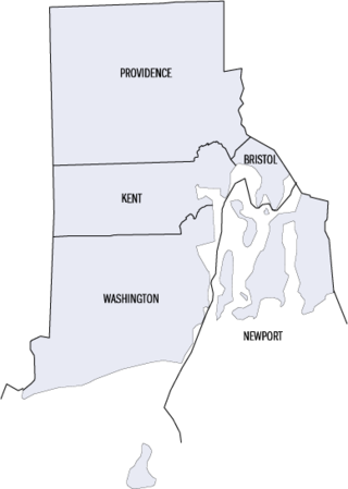
This is a list of properties and districts listed on the National Register of Historic Places in Rhode Island. As of May 29, 2015, there are more than 750 listed sites in Rhode Island. All 5 of the counties in Rhode Island have listings on the National Register.

Roger Williams Park is an elaborately landscaped 427-acre (173 ha) city park in Providence, Rhode Island and a historic district listed on the National Register of Historic Places. The park is named after Roger Williams, the founder of the city of Providence and the primary founder of the state of Rhode Island.

This is a list of the National Register of Historic Places listings in Providence County, Rhode Island.

This is a list of the National Register of Historic Places listings in Providence, Rhode Island.

The Edgewood Historic District–Taft Estate Plat is a historic district in Cranston, Rhode Island that is bounded by Windsor Road, Narragansett Bay, Circuit Drive and Broad Street. The district represents the final subdivision of a country estate amassed by industrialist Orray Taft (1793-1865). It was laid out in 1904 and most of its residential stock was built between 1905 and 1930. The average size of the lots was 5400 square feet, although there was some variance in size, and a one-acre plot was reserved for the Taft mansion. The houses are architecturally heterogeneous, reflecting all of the major styles of the period; some properties were designed by Norman Isham.

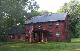
The Joy Homestead, also known as the Job Joy House, is a historic house on Old Scituate Avenue in Cranston, Rhode Island. This 2+1⁄2-story gambrel-roof wood-framed house was built between 1764 and 1778. It was occupied by members of the Joy family until 1884, and was acquired by the Cranston Historical Society in 1959. It was a stopping point on the first day's march in 1781 of the French Army troops marching from Providence to Yorktown, Virginia during the American Revolutionary War.

The Knightsville Meetinghouse was a historic church and meeting hall building at 67 Phenix Avenue within the village of Knightsville in Cranston, Rhode Island.

The Lippitt Hill Historic District is a historic district in Cranston, Rhode Island along Hope Road between Laten Knight Road and Hope Road's junction with Burlingame Road and Lippitt Avenue. This area was settled by Moses Lippitt, who in 1735 built a Georgian farmhouse for his son Christopher. Christopher later (1805) built a Federal style house for his son William. These two farmhouses are the anchors of this rural district, which also includes a historical cemetery in which many generations of Lippitts are buried, and which features a unique heart-shaped planting of pine trees.
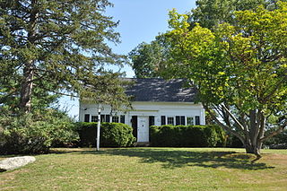
Westcote is a historic house in Cranston, Rhode Island. This 1+1⁄2-story Greek Revival cottage was built c. 1843, and was originally located on Oaklawn Avenue before being moved to its present location. It was built by a member of the locally prominent Westcott family as a farmhouse, and is a well-preserved and little-altered example of vernacular Greek Revival style.

The Broadway–Armory Historic District is a historic district encompassing a mainly residential mixed-used urban area west of downtown Providence, Rhode Island.

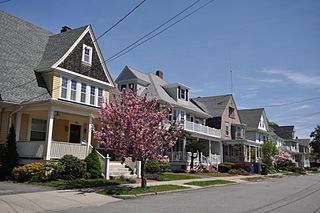
The Edgewood Historic District–Shaw Plat is a residential historic district in the Edgewood neighborhood of northeastern Cranston, Rhode Island. It is bounded by Broad Street on the west, Marion Avenue on the south, and Narragansett Bay on the east; it consists of the properties that line the parallel streets, Shaw and Marion Avenues, and the short section of Narragansett Boulevard that runs between Shaw and Marion Avenues. On the north, it abuts the separately-listed Edgewood Historic District–Arnold Farm Plat. The area was platted out between 1867 and 1895, with the construction of most of its housing taking place between 1867 and the start of World War II, with the most construction going on between 1895 and 1930. The district also includes the previously listed Edgewood Yacht Club. In 1853, the 25 acres of land that became the Shaw Plat was sold to Allen Shaw of Providence for $3,660.

The Edgewood Historic District–Arnold Farm Plat is a residential historic district in the Edgewood neighborhood of eastern Cranston, Rhode Island. It is bounded on the north by Albert Avenue, on the east by Narragansett Bay, on the south by Columbia Avenue, and on the west by Broad Street. The district was primarily built out as a streetcar suburb of Providence between 1890 and 1930, and feature styles from Queen Anne and Colonial Revival to Dutch Colonials and two- and three-decker multiunit houses. Prior to its development, the area had been farmed by several generations of the Arnold family.

Edwin Thomas Banning (1864–1940) was an American architect from Providence, Rhode Island.

The Edgewood Historic District–Anstis Greene Estate Plat is a residential historic district in the Edgewood neighborhood of eastern Cranston, Rhode Island. The 34-acre (14 ha) area is bounded on the west by Broad Street, the east by Narragansett Bay, the south by Rosewood Avenue, and on the north by Marion Avenue, where it abuts the Edgewood Historic District-Shaw Plat. The area, originally part of a much larger property belonging to Zachariah Rhodes in the 17th century, was platted for residential development in the decades following the arrival of the streetcar on Broad Street, providing commuter service to Providence. The land was willed by Anstis Rhodes Greene to a group of heirs, who progressively developed their individual portions. The only significant surviving elements that predate this development are two small family cemeteries.
This is a list of Registered Historic Places in Cranston, Rhode Island.
The Edgewood Historic District–Sally Greene Homestead Plats is a residential historic district in the Edgewood neighborhood of eastern Cranston, Rhode Island. Bounded by Glen Avenue to the north, Broad Street to the west, Massasoit Street to the south, and the Providence River to the east, this area was developed between 1900 and 1963 as a streetcar suburb for middle and lower middle class residents on what was once a country estate. The district was listed on the National Register of Historic Places in 2016.
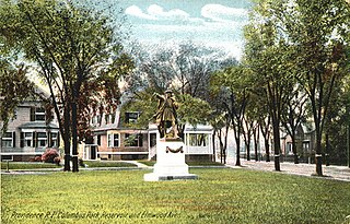
Columbus Square is a historic public square in the Historic Elmwood Neighborhood of Providence, Rhode Island. Located at the intersection of Elmwood Avenue and Reservoir Avenue, it serves as a gateway to Elmwood from the Reservoir and West End Neighborhoods.


