
West Warwick is a town in Kent County, Rhode Island, United States. The population was 31,012 at the 2020 census.

Wakefield is a village in the town of South Kingstown, Rhode Island, United States, and the commercial center of South Kingstown. Together with the village of Peace Dale, it is treated by the U.S. Census as a component of the census-designated place identified as Wakefield-Peacedale. West Kingston, another South Kingstown village, was the traditional county seat of Washington County. Since 1991, the Washington County Courthouse has been in Wakefield. The Sheriff's Office which handles corrections is also in Wakefield.

The Blackstone Canal was a manmade waterway, linking Worcester, Massachusetts, to Providence, Rhode Island, and Narragansett Bay, through the Blackstone Valley, via a series of locks and canals in the early 19th century. Construction started in 1825, and the canal opened three years later. After the opening of the Boston and Providence Railroad (1835), the canal struggled for business. Its transportation role was taken over by the Providence and Worcester Railroad, which completed a parallel line in 1847. The canal shut down in 1848. Several segments of the canal are preserved, and the canal alignment and remains are on the National Register of Historic Places.

The Mechanic Street Historic District encompasses a historic 19th-century mill and mill village in a 14-block area of the Pawcatuck section of Stonington, Connecticut. Extending along the Pawcatuck River and south of West Broad Street, the area includes a large brick mill complex on the banks of the river, and a neighborhood of well-preserved worker housing on the road grid to its west. The district was listed on the National Register of Historic Places in 1988.

Pawtuxet Village is a section of the New England cities of Warwick and Cranston, Rhode Island, United States. It is located at the point where the Pawtuxet River flows into the Providence River and Narragansett Bay.

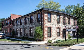
Slatersville is a village on the Branch River in the town of North Smithfield, Rhode Island, United States. It includes the Slatersville Historic District, a historic district listed on the National Register of Historic Places. The historic district has been included as part of the Blackstone River Valley National Historical Park. The North Smithfield Public Library is located in Slatersville.
Georgiaville is a village in Smithfield, Providence County, Rhode Island, United States. The village was named after the Georgia Cotton Manufacturing Company mill located in the area. The Georgiaville Pond Beach is located in the village and is a popular recreation spot. In the 1920s the Ku Klux Klan was active in the area, and Klan rallies were held in Georgiaville. The village, which has retained many features of its origin as a mid-19th century mill village, including the mill complex and several blocks of mill worker housing, was added to the National Register of Historic Places in 1985. Georgiaville is also where Smithfield's town hall is located.
Oakland is a village in Burrillville, Providence County, Rhode Island, United States. It was developed in the 19th century at the site of a stone mill near the confluence of the Chepachet and Clear Rivers. It is one of the few remaining stone mills in this state. Most of the village is included in the Oakland Historic District, a historic district listed on the National Register of Historic Places. Most of the housing in the village was originally built to house mill workers, although there are several more elaborate houses built for mill executives.
Albion is a village and historic district in Lincoln, Rhode Island, United States.

The Woonsocket Company Mill Complex is a historic district encompassing one of the largest mill complexes in Woonsocket, Rhode Island. The district includes all of the buildings historically associated with the Woonsocket Company, a major manufacturer of cotton textiles in the 19th century. The complex is located along the eastern bank of the Blackstone River between Court and Bernon Streets. It includes three handsome stone mills, built between 1827 and 1859, and a power plant that was built on the site of the former #3 mill between 1890 and 1920, as well as the remnants of the canal that originally carried water to the buildings for power.

The Wanskuck Library—A Community Library of Providence is an historic branch library building at 233 Veazie Street in Providence, Rhode Island. It is a single-story brick and stone structure, built in 1928, replacing an earlier library building which had originally housed a library established by the Wanskuck Mill Company for its employees. The building was designed by Clarke & Howe, and is an excellent local example of Colonial Revival design, with a tetrastyle entrance portico. It was the first of ten libraries built based on Howe designs.

The Hope Village Historic District is a historic rural mill settlement within Hope Village in Scituate, Rhode Island. Hope Village is located on a bend in the North Pawtuxet River in the southeastern corner of Scituate. Industrial activity has occurred in Hope Village since the mid-eighteenth century. Surviving industrial and residential buildings in the Historic District date back to the early 19th century. The village center sits at junction of Main Street and North Road. Hope Village radiates out from the center with houses on several smaller side streets in a compact configuration. Currently there is little commercial or industrial activity in Hope Village and none in the Historic District. The present stone mill building on the south side of Hope Village was built in 1844 by Brown & Ives of Providence, expanded in 1871 and modified in 1910. Approximately one quarter of the village's current housing stock was built as mill worker housing by various owners of Hope Mill.

The Shannock Historic District is a historic mill village located along the Pawcatuck River in the towns of Richmond and Charlestown, Rhode Island. The postal code for Shannock is 02875. The village extends along Old Shannock Road, Railroad Street, and Shannock Village Road between two crossings of the Pawcatuck, which forms the border between the two towns. It lies mainly in Richmond, but extends along the road running southwest and southeast from the two crossings. Two mill complexes are the visual focal points of the village: the Carmichael plant on the west, and the Columbia Narrow Fabrics Company complex near the village center. The buildings in the village are predominantly residential worker housing set close to the road, which were built in the second half of the 19th century. There are two imposing Greek Revival houses, both built c. 1850, and one Late Victorian house, all of which belonged to mill owners. The area was listed on the National Register of Historic Places in 1983.

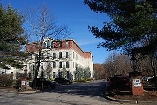
The Crompton Mill Historic District is a historic district encompassing a mill complex at 20 Remington Street, 53 and 65 Manchester Street in West Warwick, Rhode Island. The mill complex consists of a collection of mainly brick buildings, bounded by the Pawtuxet River and Pulaski, Remington, and Manchester Streets in the village of Crompton. The mill complex formerly extended across the river, but the complex on the west bank was destroyed by fire in 1992. The oldest elements of the complex are the dam site and some of the raceways that provided water power to the mills. The present dam was built in 1908, replacing an 1882 structure. The raceways were built in 1807, around the time of the first mill buildings. The stone Mill No. 1, built 1807, is believed to be the oldest stone mill building in the state. Most of the complex's buildings were built in the late 19th and early 20th centuries by the Providence Manufacturing Company and its successors. The mill was used for textile processing until 1946, when the Crompton Corporation ended production.

The Blackstone Manufacturing Company Historic District encompasses the "New City" or "High Rocks" area of Blackstone, Massachusetts, an industrial village associated with the Blackstone Manufacturing Company, which began operations in 1809. It includes an area roughly surrounding Butler, Canal, Church, County, Ives, Main, Mendon, Old Mendon, and School Streets. The district includes a wide variety of worker housing, as well as a granite storehouse, the only surviving company structure. The district was added to the National Register of Historic Places in 1995.

The East Blackstone Village Historic District is a historic district roughly along Elm Street at the junction with Summer Street in eastern Blackstone, Massachusetts. It encompasses a small 19th-century mill village center that developed along what was once a major roadway connecting Worcester with Providence, Rhode Island. The district was added to the National Register of Historic Places in 1995.

The Greystone Historic District is a historic district encompassing the early 20th-century mill village of Greystone in North Providence, Rhode Island. The district most significant elements is the Greystone Mill, a complex of brick industrial buildings on the North Providence side of the Woonasquatucket River, as well as the dam spanning the river and a water tank in Johnston. The village, entirely in North Providence, was developed between 1904 and 1912 by Joseph Benn and Company, the mill proprietors, to provide housing for its workers. The main focus of the village is on junction of Greystone Road and Oakleigh Avenue. The company built a variety of housing types, including duplexes and tenements, which line some of the side streets. There are four houses, dating as far back as 1822, that predate the primary industrial activity here. The most prominent feature of the village is the Greystone (Primitive) Methodist Church on Oakleigh Avenue.
Wanskuck is a neighborhood in the northern part of Providence, Rhode Island. Along with Charles, it is one of two neighborhoods comprising what is often referred to as the North End. Wanskuck is bounded to the east by Route 146, to the west by Providence College, Admiral Street, Route 7, and Huxley Avenue, and to the south roughly by Fillmore Street. Parts of Wanskuck north of Branch Avenue are the Wanskuck Historic District.
The Heaton and Cowing Mill is a historic industrial facility at 1115 Douglas Avenue in Providence, Rhode Island. The small mill complex consists of three connected building sections; the oldest is a c. 1832 rubble-walled two story mill building constructed by David Heaton and Martin Cowing on the banks of the West River. The partners used the facility to manufacture and dye cotton cloth. The building is the remnant of a much larger Geneva Worsted Company works that Heaton and Cowing built on the site in the 1860s and 1870s.

Blackstone River Valley National Historical Park is a National Park Service unit in the states of Rhode Island and Massachusetts. The park was created for the purpose of preserving, protecting, and interpreting the industrial heritage of the Blackstone River Valley and the urban, rural, and agricultural landscape of that region. The Blackstone River Valley was the site of some of the earliest successful textile mills in the United States, and these mills contributed significantly to the earliest American Industrial Revolution. The subsequent construction of the Blackstone Canal, a few years after the successful completion of the Erie Canal, helped to sustain the region's industrial strength.


