Manton, Providence, Rhode Island

Last updated
Providence neighborhoods with Manton in red MantonProv.JPG
Providence neighborhoods with Manton in red
Rhode Island College Superintendent's home at the former State Home and School for Dependent and Neglected Children.jpg
Rhode Island College

Manton is a residential neighborhood in Providence, Rhode Island and part of Johnston, Rhode Island. It is in the westernmost part of the city. of Providence The town of North Providence borders it to the north, Johnston to the west, while the neighborhoods of Hartford, Olneyville, and Mount Pleasant border it inside Providence. Separating it from other Providence neighborhoods to its east are Rushmore Ave, Chalkstone Ave, Smith Street, and the Triggs Memorial Golf Course. The Woonasquatucket River separates it from Johnston to the west.

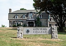
Throughout the 17th and 18th centuries, Manton remained a rural agrarian region. The eponymous Edward Manton was one of the original land owners, whose family would accumulate a huge tract of land. Toward the late 18th and early 19th centuries, the proximity of the Woonasquatucket River was responsible for the establishment of a few tanneries in Manton and neighboring Olneyville. The rural location of Manton made it ideal for the establishment of vacation homes. A stagecoach inn was one of the earliest places to take summer vacations. In 1835, the hotel was converted to a school. In 1862, the school was demolished to make way for present-day Rhode Island College.

Taking advantage of the water power provided by the Woonasquatucket River, early industrialists established mills, the first two being constructed in 1827 and 1830. Railroad lines running east through Olneyville to Downtown facilitated the rapid development of the area, which was heavily industrial by the end of the 19th century.

The closure of the textile mills and collapse of heavy industry encouraged the exodus of working class residents to the suburbs. A public housing project, Manton Heights, was built in 1953, and may have contributed to the white flight. During the 1970s Manton lost 15 percent of its population. By the 1980s Manton Heights had, like so many public housing complexes, fallen into disrepair. The Manton-Fruit Hill Neighborhood Association was founded about this time and encourages neighborhood participation and improvement.

Demographics

Manton's population nearly doubled from 1,406 in 1980 to 2,584 in 1990. In 1990, 90 percent of Manton was white, 4 percent Native American, 2 percent black, and 1 percent Hispanic. Almost two-thirds of residents over the age of 25 had completed high school. The largest sources of employment were professional services (28.2%), manufacturing (21.4%), and retail trade (19.4%). The 11.2 percent unemployment rate in Manton is higher than the 9.2 percent rate for the city as a whole.

The median family income in Manton in 1989 was $27,262, which is 4 percent lower than the citywide average. Poverty rate had increased from 2.1 percent in 1980 to 12.2 percent in 1990, while families below the poverty line rose from 2.1 percent to 8.6 percent. The rate of elderly living in poverty rose from 2.9 percent in 1980 to 23.9 percent in 1990.

The number of housing units in Manton more than doubled recently, increasing from 549 in 1980 to 1,227 in 1990. Since most of these were rental units, the owner-occupied units declined from 63 percent to 41.7 percent.

The housing stock in Manton is also fairly new. More than one in three units were built within the last decade, and almost half of all units were constructed within the past 20 years. The median value of a single family owner-occupied housing unit in Manton in 1990 was $103,900, which was 7 percent lower than the citywide median. The median rent in Manton was 8 percent lower than the citywide figure.

Related Research Articles

Providence County, Rhode Island County in Rhode Island, US

Providence County is the most populous county in the U.S. state of Rhode Island. As of the 2010 census, the county's population was 626,667, or 59.5% of the state's population. Providence County contains the city of Providence, the state capital of Rhode Island and the county's most populous city, with an estimated 179,335 residents in 2018. Providence County is included in the Providence-Warwick, RI-MA Metropolitan Statistical Area, which in turn constitutes a portion of the greater Boston-Worcester-Providence, MA-RI-NH-CT Combined Statistical Area. In 2010, the center of population of Rhode Island was located in Providence County, in the city of Cranston.

Johnston, Rhode Island Town in Rhode Island, United States

Johnston is a town in Providence County, Rhode Island, United States. The population was 28,769 at the 2010 census. Johnston is the site of the Clemence Irons House (1691), a stone-ender museum, and the only landfill in Rhode Island. Incorporated on March 6, 1759, Johnston was named for the colonial attorney general, Augustus Johnston.

North Providence, Rhode Island Town in Rhode Island, United States

North Providence is a town in Providence County, Rhode Island, United States. The population was 32,078 at the 2010 census.

Melrose, Bronx Neighborhood of the Bronx in New York City

Melrose is a mostly residential neighborhood in the southwestern section of the New York City borough of the Bronx. It adjoins the business and one-time theater area known as The Hub. Melrose is rectangular-shaped, being bordered by Third Avenue on the east, 149th Street on the south, Park Avenue on the west and 161st Street to the north. Melrose Avenue and Third Avenue are the primary thoroughfares through Melrose.

Olneyville, Providence, Rhode Island

Olneyville is a neighborhood in Providence, Rhode Island bordered by Atwells Avenue to the north, U.S. Route 6 to the south and Rhode Island Route 10 to the east. The Woonasquatucket River runs through the southern portion of the neighborhood. The area is roughly triangular.

Woonasquatucket River

The Woonasquatucket River is a river in the U.S. state of Rhode Island. It flows approximately 15.8 miles (25.4 km) and drains a watershed of 130 km2 (50 sq mi).

Federal Hill, Providence, Rhode Island Place

The Federal Hill neighborhood has a salient role in the history of Providence due to its central location within the city. This part of Providence is best known for its Italian American community and abundance of Italian restaurants.

Smith Hill, Providence, Rhode Island United States historic place

Smith Hill is a neighborhood in Providence, Rhode Island. Its traditional bounds are the Woonasquatucket River, the Chad Brown public housing complex, Interstate 95 and West River.

Blackstone, Providence, Rhode Island

Blackstone is a predominantly residential neighborhood in Providence, Rhode Island. It is in the northeast corner of the city and is bounded to the south and west by Lloyd Avenue and Hope Street respectively. It is one of six neighborhoods comprising the East Side of Providence.

College Hill, Providence, Rhode Island Neighborhood in Providence, Rhode Island, United States

College Hill is a historic neighborhood of Providence, Rhode Island, and one of six neighborhoods comprising the city's East Side. It is roughly bounded by South and North Main Street to the west, Power Street to the south, Governor Street and Arlington Avenue to the east and Olney Street to the north. The neighborhood's primary commercial area extends along Thayer Street, a strip frequented by students in the Providence area.

Fox Point, Providence, Rhode Island Place in Rhode Island, United States

Fox Point is a neighborhood in the East Side of Providence, Rhode Island. It is bounded by the Providence and Seekonk rivers, Interstate 195 and the College Hill and Wayland neighborhoods. Fox Point is the southernmost neighborhood in the East Side area of Providence.

Charles, Providence, Rhode Island

Charles is a neighborhood in northern Providence, Rhode Island. Along with Wanskuck, it comprises what is sometimes referred to as the North End. To the west Charles is partitioned from Wanskuck by Route 146, while the Chad Brown public housing complex separates Charles from Smith Hill to the south, and the West River and Interstate 95 bounds the area to the east. The city limits abutting the city of North Providence bound Charles to the north.

West End, Providence, Rhode Island Neighborhood in the southwestern part of Providence, Rhode Island

The West End is a neighborhood in the southwestern part of Providence, Rhode Island in the region often referred to as the South Side. Its boundaries are delineated by Westminster Street to the north, Huntington Avenue to the south, Elmwood Avenue to the east and the railroad tracks with Route 10 to the west. Cranston Street runs through the center of West End, past the Cranston Street Armory which has given the neighborhood the alternative name of the "Armory District."

Elmhurst, Providence, Rhode Island

Elmhurst is a primarily residential neighborhood in the northwest quadrant of Providence, Rhode Island. Douglas Avenue and Admiral Street bound Elmhurst to the northeast, Academy Avenue and Smith Street bound it to the west, while Chalkstone Avenue marks the southern border.

Silver Lake, Providence, Rhode Island

Silver Lake is a neighborhood on the western edge of Providence, Rhode Island. It is bordered by the Hartford neighborhood to the north, Route 10 to the east, Johnston and Cranston on the West and separated from Olneyville by Route 6.

Hartford, Providence, Rhode Island

Hartford is a neighborhood located along the western edge of Providence, Rhode Island. Route 6 and the Woonasquatucket River separates it from Olneyville.

Upper South Providence, Providence, Rhode Island

Upper South Providence is an official neighborhood in the South Side in the city of Providence, Rhode Island. It is bound to the north by Interstate 95, the east by the Providence River, to the south by Public Street, and the west by Broad Street. Often associated with Lower South Providence directly to its south, Upper South Providence is a distinct neighborhood.

Hope, Providence, Rhode Island

Hope is a neighborhood on the northern border of Providence, Rhode Island. To the west, it is bounded by North Main Street, the North Burial Ground, and Interstate 95, while Rochambeau Ave, Hope Street, and the Providence-Pawtucket city line roughly delineate its boundaries to the south, east, and north respectively. Hope is sometimes referred to as "Summit", named for the street that runs through the middle of the neighborhood. Though "Hope" is officially recognized, residents and the local neighborhood organization more often use "Summit".

Mount Pleasant, Providence, Rhode Island

Mount Pleasant is a working-class residential neighborhood situated in the northwest of the city of Providence, Rhode Island. It is bordered by Olneyville to the south, Valley to the east, Manton to the west, and Elmhurst to the northeast, and the Town of North Providence to the north. The major street boundaries that define Mount Pleasant are Academy Avenue to the east, Smith Street to the northeast, Atwells Avenue to the south, and portions of Bullock, Chalkstone, Mera, and Rushmore Avenues to the west.

Valley, Providence, Rhode Island

Valley is a neighborhood in northwestern Providence, Rhode Island. It is bounded to the north by Chalkstone Avenue, to the east by Raymond Street, to the south by Harris Avenue and Atwells Avenue, and to the west by Academy Avenue. The population of the neighborhood, as of 2000, was 4,765.

References

    Coordinates: 41°50′02″N71°28′00″W / 41.8339°N 71.4667°W / 41.8339; -71.4667