Jewelry District (Providence)

Last updated
Jewelry District
Davol Square PVD.jpg
Providence Jewelry District Locator.svg
Location of the Jewelry District (dark gray) and Downtown (medium gray) in Providence
Coordinates: 41°49′05″N71°24′25″W / 41.818°N 71.407°W / 41.818; -71.407 Coordinates: 41°49′05″N71°24′25″W / 41.818°N 71.407°W / 41.818; -71.407

The Jewelry District is a neighborhood of Providence, Rhode Island located just southeast of Downtown. The historical path of Interstate 195 delineates the neighborhood's northern border while Interstate 95 and the Providence River define its western, southern and eastern edges. [1] [2]

Contents

Beginning in the 19th century, the area became a center of jewelry manufacturing. In the 1960s, the area was detached from the rest of Downtown with the construction of Interstate 195. A major construction project completed in 2013 relocated Interstate 195 further south, reconnecting the district with Downtown Providence and freeing 19 buildable acres of land. [3] [4]

Contained within the Jewelry District neighborhood is the Providence Jewelry Manufacturing Historic District, added to the National Register of Historic Places in 1985 and expanded in 2012.

History

During 19th and 20th centuries, the manufacturing of jewelry and costume jewelry emerged as a dominant local industry. [5] [6] Jewelry manufacturing began in the Providence in 1794; by 1880 Rhode Island's jewelry industry accounted for more than one quarter of the nation's jewelry production. [7] The industry peaked in 1978 with 32,500 workers, then began a swift decline. [5] By 1996, the number of jewelry workers shrank to 13,500. [5]

Over the following decades, the large jewelry factories that had once dominated the Jewelry District were closed or vacated.

During the 2000s and early 2010s, a segment of Interstate 195 that marked the northeastern edge of the Jewelry District was relocated south. Dubbed the "Iway", the relocation project made available buildable 19 acres of land in and adjacent to the Jewelry District. Since 2018, a number of major projects have begun and been completed on and adjacent to the redevelopment parcels. Among the development project are multiple housing complexes, a six story parking garage, and a hotel. [8] [9]

The city and state have marketed the new neighborhood as Providence's "Innovation & Design District", with the intention of establishing the area as a hub for science, technology, and education in the city. [10] [11]

In 2019, the city opened a new pedestrian bridge, connecting the Jewelry District to East Side; an adjacent waterfront park was opened the following year. [12]

Geography

Landmarks

South Street Landing in 2021 South Street Station.jpg
South Street Landing in 2021

The Fox Point Hurricane Barrier is the most prominent feature of this area. The barrier protects Providence from storm surge flooding like that it endured in the 1938 New England Hurricane and again in 1954 from Hurricane Carol. [13] In both storms, downtown flooded to a depth of over eight feet at some locations. [14] Downtown has not suffered substantial flooding since the construction of the barrier.

Additionally recognizable are the three smokestacks of the Manchester Street Generating Station and the large brick form of South Street Station.

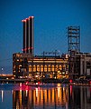
South Street Landing is a prominent structure in the neighborhood, located on Eddy Street right on the river, adjacent to the Point Street Bridge. The large building had served as a power station from 1912 to 1995, and subsequently sat vacant and decaying for many years. [8] Various redevelopment projects were proposed which never came to fruition. [8] In 2017 the structure was entirely renovated and re-opened under the name South Street Landing. [8] The building is shared by Brown University, Rhode Island College, and University of Rhode Island. [8] A 750-space parking garage was constructed adjacent to the building. [8]

Collier Point Park

Collier Point Park is located along the Providence waterfront south of Davol Square. The park was home to a decommissioned Russian submarine, Juliet 484, which was used in 2000 for the filming of the movie K-19: The Widowmaker in Halifax, Nova Scotia. [15] The submarine had been in use as a museum until the submarine sank in a storm April 17–18, 2007. The submarine's owners had planned to salvage the submarine and reopen the museum, but were unable to obtain sufficient funds for the project.

Related Research Articles

Interstate 195 (I-195) is an Interstate Highway running a combined 44.23 miles (71.18 km) in the U.S. states of Rhode Island and Massachusetts. It travels from a junction with I-95 in Providence, Rhode Island, east to a junction with I-495 and Route 25 in Wareham, Massachusetts. It runs east–west and passes through the cities of Fall River, Massachusetts, and New Bedford, Massachusetts. The portion of I-195 in East Providence is also known as the East Providence Expressway.

Route 10 is a numbered state highway connector in the U.S. state of Rhode Island, traveling along the Huntington Expressway, the first freeway in the state. It connects Route 12 on the Cranston–Providence city line with Interstate 95 (I-95), U.S. Route 6 (US 6), and Memorial Boulevard in downtown Providence, passing just east of the Olneyville area of Providence. It provides an alternate route to I-95 south of downtown, and connects it with the US 6 freeway west from Olneyville towards I-295 and Connecticut.

Interstate 95 (I-95) is the main north–south Interstate Highway on the east coast of the United States, running generally southwest-northeast through the U.S. state of Rhode Island. It runs from the border with Connecticut near Westerly, through Warwick and Providence, and to the Massachusetts state line in Pawtucket. It has two auxiliary routes, both of which enter Massachusetts—I-195: a spur from Providence east to Cape Cod, and I-295, a western bypass of the Providence-Pawtucket area.

U.S. Route 6 (US 6) is a major east–west road in the U.S. state of Rhode Island. Nationally, the route continues west to Bishop, California and east to Provincetown, Massachusetts. In western Rhode Island, it forms part of one of several routes between Hartford, Connecticut and Providence, Rhode Island, and was planned to be replaced by Interstate 84. The part of I-84 that was built, from Interstate 295 to Olneyville, is now part of US 6. At Olneyville, US 6 joins Route 10 and heads east towards downtown Providence, where it turns south on Interstate 95 and east on Interstate 195. US 6 splits from I-195 in East Providence, crossing into Massachusetts on Warren Avenue. The whole route of US 6 is a state highway maintained by the Rhode Island Department of Transportation.

History of Providence, Rhode Island

The Rhode Island city of Providence has a nearly 400-year history integral to that of the United States, including significance in the Transatlantic Slave Trade and the American Revolutionary War by providing leadership and fighting strength, quartering troops, and supplying goods to residents by circumventing the blockade of Newport. The city is also noted for the first bloodshed of the American Revolution in the Gaspée Affair. Additionally, Providence is notable for economic shifts, moving from trading to manufacturing; the decline of manufacturing devastated the city during the Great Depression, but the city eventually attained economic recovery through investment of public funds.

College Hill, Providence, Rhode Island Neighborhood of Providence in Rhode Island, United States

College Hill is a historic neighborhood of Providence, Rhode Island, and one of six neighborhoods comprising the city's East Side. It is roughly bounded by South and North Main Street to the west, Power Street to the south, Governor Street and Arlington Avenue to the east and Olney Street to the north. The neighborhood's primary commercial area extends along Thayer Street, a strip frequented by students in the Providence area.

Fox Point, Providence, Rhode Island Neighborhood of Providence in Rhode Island, United States

Fox Point is a neighborhood in the East Side of Providence, Rhode Island. It is bounded by the Providence and Seekonk rivers, Interstate 195 and the College Hill and Wayland neighborhoods. Fox Point is the southernmost neighborhood in the East Side area of Providence.

India Point Park

India Point Park is a park in the Fox Point neighborhood of Providence, Rhode Island at the confluence of the Seekonk River and Providence River. The park takes its name from the maritime activity connecting Providence with the East and West Indies. The East Bay Bike Path begins at the eastern end of the park, and crosses over the Washington Bridge before heading to Watchemoket Square in East Providence and continuing on to Bristol and the Mount Hope Bridge. The park is also a part of the Washington–Rochambeau Revolutionary Route.

Providence River River in Rhode Island, United States

The Providence River is a tidal river in the U.S. state of Rhode Island. It flows approximately 8 miles (13 km). There are no dams along the river's length, although the Fox Point Hurricane Barrier is located south of downtown to protect the city of Providence from damaging tidal floods.

East Side, Providence, Rhode Island

The East Side is a collection of neighborhoods in the eastern part of the city of Providence, Rhode Island. It officially comprises the neighborhoods of Blackstone, Hope, Mount Hope, College Hill, Wayland, and Fox Point.

Fox Point Hurricane Barrier

The Fox Point Hurricane Barrier is a 3,000-foot (910 m) long tidal flood barrier spanning the Providence River in Providence, Rhode Island, located 750 feet (230 m) upstream from Fox Point. It was constructed between 1960 and 1966 to protect the low-lying downtown area of the city from damaging storm surge and floods associated with hurricanes and other major storm events.

Downtown, Providence, Rhode Island United States historic place

Downtown is the central economic, political, and cultural district of the city of Providence, Rhode Island. It is bounded on the east by Canal Street and the Providence River, to the north by Smith Street, to the west by Interstate 95, and to the south by Henderson Street. I-95 serves as a physical barrier between the city's commercial core and neighborhoods of Federal Hill, West End, and Upper South Providence. Most of the downtown is listed on the National Register of Historic Places as the Downtown Providence Historic District.

Neighborhoods in Providence, Rhode Island

The city of Providence, Rhode Island has 25 official neighborhoods.

Lower South Providence, Providence, Rhode Island

The Lower South Side is a neighborhood in the southern part of Providence, Rhode Island. It is bounded by Public Street to the north, by Interstate 95 to the south, by Broad Street to the west, and by the Providence River to the east.

Providence Jewelry Manufacturing Historic District United States historic place

The Providence Jewelry Manufacturing Historic District is a predominantly industrial historic district in Providence, Rhode Island. It covers a roughly 19-acre (7.7 ha) area in the city's Jewelry District, just south of Downtown Providence. While the area began as a residential neighborhood, it emerged in the late 19th and early 20th centuries as a center of Providence's jewelry manufacturing businesses. The oldest industrial building in the district is the 1848 Elm Street Machine Shop, a 2+12-story stone structure that now houses offices of Brown University.

Davol Square

Davol Square is a historic public square in central Providence, Rhode Island. It is located at the intersection of Point Street and Eddy Street in the Upper South Providence neighborhood, in the middle of the Jewelry District.

Providence, Rhode Island Capital of Rhode Island

Providence is the capital and most populous city of the U.S. state of Rhode Island. One of the oldest cities in the United States, it was founded in 1636 by Roger Williams, a Reformed Baptist theologian and religious exile from the Massachusetts Bay Colony. He named the area in honor of "God's merciful Providence" which he believed was responsible for revealing such a haven for him and his followers. The city is situated at the mouth of the Providence River at the head of Narragansett Bay.

Freeway removal

Freeway removal is a public policy of urban planning policy to demolish freeways and create mixed-use urban areas, parks, residential, commercial, or other land uses. Such highway removal is often part of a policy to promote smart growth, transit-oriented development, walkable and bicycle-friendly cities. In some cases freeways are re-imagined as boulevards, rebuilt as tunneled freeways or relocated through less densely-developed areas.

The following is a timeline of the history of the city of Providence, Rhode Island, United States.

Michael S. Van Leesten Memorial Bridge

The Michael S. Van Leesten Memorial Bridge is a footbridge crossing the Providence River located in the city of Providence, Rhode Island. The bridge connects Providence's Fox Point neighborhood to the city's Jewelry District. Originally known as the Providence River Pedestrian Bridge, in July 2020 it was renamed in honor of Michael S. Van Leesten.

References

  1. "Providence Neighborhood Profiles". Archived from the original on 2008-11-20. Retrieved 2009-05-18.
  2. The Jewelry District
  3. RIDOT's Iway - Relocating I-195 in Providence Archived 2005-11-09 at the Wayback Machine
  4. Abbott, Elizabeth (2015-08-18). "Providence, R.I., Is Building on a Highway's Footprint". The New York Times. ISSN   0362-4331 . Retrieved 2021-09-12.
  5. 1 2 3 Abbott, Elizabeth (26 January 1997). "Providence Jewelry District Gets a New Luster". The New York Times. Retrieved 27 July 2016.
  6. Davis, Paul (4 July 2015). "R.I.'s jewelry industry history in search of a permanent home". Providence: The Providence Journal. Retrieved 27 July 2016. In 1794, Seril Dodge opened a jewelry store on North Main Street in Providence, and Nehemiah Dodge developed a process for coating lesser metals with gold and silver. Historians say that the two men started Rhode Island’s jewelry industry.
  7. Lightfoot, D. Tulla (2019-02-21). The Culture and Art of Death in 19th Century America. McFarland. p. 132. ISBN   978-1-4766-3518-7.
  8. 1 2 3 4 5 6 Nesi, Ted (29 November 2017). "Old power station transformed as ribbon cut on $220M South Street Landing project". WPRI Eyewitness News. Retrieved 3 May 2018.
  9. Fenton, Josh. "New Providence — Wexford & Pedestrian Bridge Shift City's Focus From Superman and Financial District". GoLocalProv. Retrieved 2020-11-17.
  10. Brown, Eliot (2014-03-05). "Providence Reclaims a 'Link' to Its Past". The Wall Street Journal. ISSN   0099-9660 . Retrieved 2020-10-20.
  11. D'Ambrosio, Daniel. "How Rhode Island Is Sparking Another Industrial Revolution". Forbes. Retrieved 2020-10-21.
  12. NEWS, R. J. HEIM, NBC 10 (2020-05-21). "Waterfront parks adjacent to the Providence pedestrian bridge ready to open soon". WJAR. Retrieved 2020-11-17.
  13. "History: A Rhode Island Tradition". The Providence Biltimore. Archived from the original on 2007-07-07. Retrieved 2007-07-11.
  14. Providence Emergency Management Agency
  15. "Juliett 484 - A History of Submarine K-77". Archived from the original on 2007-09-28. Retrieved 2007-08-04.
  16. List, Madeleine. "R.I., Providence officials laud opening of 'beehive of innovation'". providencejournal.com. Retrieved 2021-03-12.