Dutch Island Light

Last updated
Dutch Island Light
Dutch Island Lighthouse.jpg
Dutch Island light in 2009, viewed from a kayak
Dutch Island Light
Location Jamestown, Rhode Island
Coordinates 41°29′48.27″N71°24′15.35″W / 41.4967417°N 71.4042639°W / 41.4967417; -71.4042639 Coordinates: 41°29′48.27″N71°24′15.35″W / 41.4967417°N 71.4042639°W / 41.4967417; -71.4042639
Tower
Constructed1826
FoundationSurface rock
ConstructionBrick
Height13 m (43 ft)  OOjs UI icon edit-ltr-progressive.svg
ShapeSquare
MarkingsWhite with black lantern
HeritageNational Register of Historic Places listed place  OOjs UI icon edit-ltr-progressive.svg
Fog signal none
Light
First lit1857
Automated1947
Deactivated1979 - 2007
Focal height56 feet (17 m)
Lens4th order Fresnel lens (original), 9.8 inches (250 mm) (current)
Characteristic Flashing red 6 seconds
Dutch Island Lighthouse
Dutch Island Light USCG.JPG
Built1857
MPS Lighthouses of Rhode Island TR
NRHP reference No. 87001701 [1]
Added to NRHPFebruary 25, 1988
Dutch Island Light postcard Dutch Island.jpg
Dutch Island Light postcard

Dutch Island Light is a historic lighthouse on Dutch Island off Jamestown, Rhode Island. [2] [3] [4]

Contents

In 1825 the federal government acquired 6 acres (2.4 ha) at the southern end of the island, and on January 1, 1827, Dutch Island Light was established to mark the west passage of Narragansett Bay and to aid vessels entering Dutch Island Harbor. The first 30-foot (9.1 m) tower was built of stones found on the island. The government constructed a new 42-foot (13 m) brick tower in 1857 with a fog bell added in 1878.

Additional history

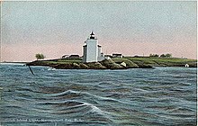
Dutch Island is located in the West Passage of Narragansett Bay between Jamestown and Saunderstown, Rhode Island. Originally it was called "Quetenis" by the Narragansett people, who sold it to the Dutch West India Company about 1636. The Dutch from New Amsterdam (later New York) used the island as a safe place to trade their goods to the Narragansett for meat, fish and furs. Later the English settlers of Rhode Island used the island to graze sheep.

For many years it was fortified to protect the West Passage from sea invasion. It is not known whether this included the Revolutionary War era when the Conanicut Battery was activated further south on the western shore of Conanicut (Jamestown) Island. Dutch Island was later heavily fortified with massive concrete gun emplacements. These were started with large granite store structures near the southern end of the island during the Civil War. In the late 19th century there was a battery of 15-inch (380 mm) Rodman guns (25-ton cannon which used a 50-pound charge of black powder to fire a 300-pound cannonball as far as 3 miles (4.8 km)) on the point at the southern end of the island.

In the late 1890s the Army established Fort Greble on Dutch Island. Fort Greble was an Endicott-era coastal fortification which featured long-range rifled artillery pieces and could house as many as 495 officers and men. Fort Greble was an active post until 1924 and was used for National Guard training up to World War II.

In 1825, the U.S. government bought 6 acres (24,000 m2) on the southern tip of the island with the purpose of establishing a "light station". The first tower was built in 1826 using native stone from the island. It was 30 feet (9.1 m) tall. One of the first keepers was Robert Dennis, whose father had fought in the Revolution and who was also present at the Boston Tea Party. Dennis was 78 years old when he became keeper and apparently remained keeper until he was well into his nineties. His son, Robert, took his position when his father died.

According to Jeremy D'Entremont, a member of the American Lighthouse Foundation and the first Board of Directors of the Dutch Island Lighthouse Society, the lighthouse and keeper's house were described in the mid-19th century as "the worst construction of any in the state", and the lantern was described as "wretched".

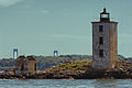
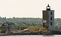
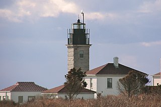
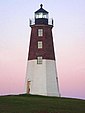
In 1857, the old tower and the Keeper's House were demolished and replaced by the present 42-foot (13 m) brick tower and a four-room Keeper's House. The basic structure of this tower was described in 2007 as still being "very sound". The cost of these two structures in the 1850s was $4,000, and included a "fourth-order" Fresnel lens and a fixed white light. In 1878, a fog bell was installed on the west side of the tower to be activated by a clockwork mechanism.

In 1924, a flashing red kerosene light was installed, the lens for which was rotated by "…a very big weight on pulleys", recalls a local resident.

Keepers:

John Paul was one of the last keepers (1929–1931), and his son Louis remembered that this father kept a vegetable garden and a flock of ducks. He said that the fishing off the rocks was "excellent" and that his father would catch "…a bushel of blackfish before breakfast." He would buy a whole side of beef in Jamestown or Saunderstown, salt it thoroughly and keep it for prolonged use.

In 1947, the light was automated and lit by electricity, as a flashing red beacon. The military left the island, and in 1950 the Keeper's House was demolished because of vandalism and because toadstools and moss were growing in the house.

In 1972, the Coast Guard proposed discontinuing the light altogether. This was followed by at least 40-50 letters of protest written to the Rhode Island Department of Natural Resources and to the Coast Guard. As a result, the Coast Guard not only retained the light but even increased its intensity. Extensive vandalism, however, continued and again the proposition to discontinue the light was made in 1977. This time it was discontinued and was replaced by a flashing red buoy off the tip of the island in 1979.

Dutch Island Lighthouse Society is formed

The Dutch Island Lighthouse Society was born in 2000 as a Chapter of the American Lighthouse Foundation and with the objective of restoring the lighthouse and hopefully a functioning light.

In May 2000, the lighthouse was visited by Dave Lombardi, Keith Fornal, Jeremy D'Entremont and Chris Powell of the Rhode Island Department of Environmental Management (which had jurisdiction over the island). In June 2000, Ginger Hesse and Roberta Randall of the Rhode Island State Historic Preservation Office also visited the lighthouse. The building, though needing extensive repairs, was found to be basically very sound, and they named it an Historic Building.

In the summer of 2001, DILS filed an application for funds for restoration and reactivation with an estimated cost of $120,000, and the application was "accepted". It took another 7 years to complete all the many details of design, planning, restoration and activation along with endless encounters with "red tape". Meanwhile, a set of by-laws was approved which established a board of directors.

In January 2004, DILS was accepted as a non-profit organization in the state of Rhode Island. The DILS treasurer, Betty Aschman, reported that there was $16,000 from "big donors" including the Kimball Foundation, BankNewport's Community Fund, and several family foundations. There were 188 "small" donors, and on May 21, 2004, Al Potter reported that the Society had an easement agreement with the state and the necessary insurance and project agreement. On July 1, 2004, the visitors to the island included key people from the Rhode Island Department of Transportation and Keith Lescarbeau, who was the president and owner of the Abcore Restoration Company that was already at work on Plum Beach Light.

By the spring of 2005, DILS negotiated a long-term lease from the DEM, which was in charge of the island for the state, including the lighthouse. In July of that year, engineering firm Vanasse Hangen and Brustlin (VHB) visited the lighthouse with Bill DeSantis of RIDOT, architect Richard Ventrone, Jr., and planner Arnold Robinson of the Newport Collaborative Architects. (Campbell Construction Co. had already had a site visit). Their charge was to come up with drawings and specifications that would get the job done and relight the light, and if possible, to stay within the $120,000 grant from RIDOT.

The details of their specifications had to be cleared by the DILS Building Committee, RIDOT, the town of Jamestown, the US Coast Guard and RIDEM (Parks Department) before the Society could advertise for bids. After a short time, RIDOT gave DILS permission to advertise for bids; the Building Committee reviewed the four bids. The winning bidder was Abcore Restoration of Narragansett, which had a very good reputation and had recently completed the restoration of the Plum Beach Lighthouse, also in Narragansett Bay. Keith Lescarbeau, the president and owner of Abcore, was also well known and admired in the area. The Building Committee's choice of Abcore was approved by the Board of Directors, and on July 3, 2007, Craig Amerigian agreed to serve as the DILS Project Manager and Owner Representative.

Abcore started July 25. They made a temporary landing area on the rock near the lighthouse of about 20 tires tied together and built a plywood walkway from this landing area to the lighthouse. They had a small launch with a hoist which transported all the scaffolding, ladders and supplies to the island from Jamestown. It was heartening to see the scaffolding in place and to watch the exterior gradually change from mottled brown to gleaming white with the final parging.

Another detail in the rebuilding was the fabrication and testing of a solar-powered workable light, as well as chipping away all loose material on the exterior of the tower, repairing with tuck pointing, coating with a parging (tested in Newport for appropriate whiteness) and then coating with an antifungal material. The roof had to be replaced. The glass in the tower had to be replaced with double glazing. The brass window frames needed repair and replacement, and much of the walkway also needed repair and replacement. Considerable work had to be done to the inside staircase, wooden window boards were replaced with metal ones, and the door was replaced.

The separate small "oil house" was cleaned out and fitted with a new roof and door, and the exterior was refinished.

The grant from RIDOT specifically stated that the grant money could not be used for maintenance, nor would RIDOT or the Enhancement Program pay for maintenance. The final field report was received from the Newport Collaborative Architects on November 20, 2007.

On November 17, 2007, many gathered at vantage points to see the great occasion. At the appointed time (7:00 p.m.) the "count-down" was started, the cannon fired, and founding member Shirley Sheldon pushed the button, and for the first time in 28 years Dutch Island had a flashing red light and a gleaming white lighthouse.

See also

Notes

  1. "National Register Information System". National Register of Historic Places . National Park Service. January 23, 2007.
  2. Light List, Volume I, Atlantic Coast, St. Croix River, Maine to Shrewsbury River, New Jersey (PDF). Light List. United States Coast Guard. 2012. p. 179.
  3. "Historic Light Station Information and Photography: Rhode Island". United States Coast Guard Historian's Office. Archived from the original on 2017-05-01.
  4. Rowlett, Russ (2012-10-31). "Lighthouses of Rhode Island". The Lighthouse Directory. University of North Carolina at Chapel Hill.
  5. ancestry.com

Related Research Articles

Jamestown, Rhode Island Town in Rhode Island, United States

Jamestown is a town in Newport County, Rhode Island in the United States. The population was 5,559 at the 2020 census. Jamestown is situated almost entirely on Conanicut Island, the second largest island in Narragansett Bay. It also includes the uninhabited Dutch Island and Gould Island.

Conanicut Island Island in Rhode Island, USA

Conanicut Island is the second-largest island in Narragansett Bay in the American state of Rhode Island. It is connected on the east to Newport on Aquidneck Island via the Claiborne Pell Bridge, commonly known as the Newport Bridge, and on the west to North Kingstown on the mainland via the Jamestown-Verrazano Bridge. The town of Jamestown comprises the entire island. The U.S. Census Bureau reported a land area of 24.46 km2 (9.44 sq mi) and a population of 5,622 in 2000.

Rose Island Light lighthouse on Rose Island, Narragansett Bay, Rhode Island

The Rose Island Light, built in 1870, is on Rose Island in Narragansett Bay in Newport, Rhode Island in the United States. It is preserved, maintained and operated by The Rose Island Lighthouse Foundation.

Jamestown Bridge Now-demolished bridge in Narragansett Bay, Rhode Island

The Jamestown Bridge,, was a cantilever truss bridge that connected Conanicut Island to mainland North Kingstown, Rhode Island, spanning the West passage of Narragansett Bay. The bridge first opened to traffic in 1940, replacing ferry service as the primary connection for the town of Jamestown, situated on Conanicut Island. It was constructed for just over $3 million 1940 USD, which was paid for by tolls until June 28, 1969. With a total length of 6,892 feet, the Jamestown Bridge was the third longest in Rhode Island at the time of its destruction, ranking behind its replacement, the adjacent 7,350-foot Jamestown Verrazzano Bridge, and the 11,248-foot Claiborne Pell Newport Bridge connecting Conanicut Island to Aquidneck Island and Newport. The Jamestown Bridge was closed to vehicular traffic on October 8, 1992, and its main span was destroyed through a controlled demolition on April 18, 2006.

Newport Harbor Light

The Newport Harbor Light, also known as the Goat Island Light or Green Light, built in 1842, is located on north end of Goat Island, which is part of the city of Newport, Rhode Island, United States, in Narragansett Bay. The light was added to the National Register of Historic Places in 1988.

Dutch Island (Rhode Island)

Dutch Island is an island lying west of Conanicut Island at an entrance to Narragansett Bay in Rhode Island, United States. It is part of the town of Jamestown, Rhode Island, and has a land area of 0.4156 km². It was uninhabited as of the United States Census, 2000. The island was fortified from the American Civil War through World War II and was known as Fort Greble from 1898 to 1947.

Beavertail State Park State park in Rhode Island, United States

Beavertail State Park is a public recreation area encompassing 153 acres (62 ha) at the southern end of Conanicut Island in Narragansett Bay, Rhode Island. The state park's main attraction is the active Beavertail Lighthouse, the current tower of which dates from 1856. During World War II, the park area was part of Fort Burnside, one of several coastal fortifications designed to protect Narragansett Bay. The park's scenic shoreline offers hiking, picnicking, and saltwater fishing.

Beavertail Lighthouse United States historic place

Beavertail Lighthouse was built in 1856 and is the premier lighthouse in Rhode Island, marking the entrance to Narragansett Bay. The 64-foot (20 m) lighthouse lies on the southernmost point of Conanicut Island in the town of Jamestown, Rhode Island in Beavertail State Park, on a site where beacons have stood since the early 18th century. The light provides navigation for boats and ships entering Narragansett Bay in the East Passage between Conanicut Island and Newport, Rhode Island on Aquidneck Island. Other lighthouses are visible from Beavertail Lighthouse, such as Castle Hill Lighthouse, Point Judith Light, and Rose Island Light.

Castle Hill Light

Castle Hill Lighthouse is located on Narragansett Bay in Newport, Rhode Island at the end of the historic Ocean Drive. It is an active navigation aid for vessels entering the East Passage, between Conanicut Island and Aquidneck Island. The lighthouse has become a symbol of Newport, and a frequent site for wedding photos, proposals, and tourist photos. Although the property is owned by the nearby Castle Hill Inn, the lighthouse is owned by the United States Coast Guard.

Fort Wetherill Historic site in Rhode Island, United States

Fort Wetherill is a former coast artillery fort that occupies the southern portion of the eastern tip of Conanicut Island in Jamestown, Rhode Island. It sits atop high granite cliffs, overlooking the entrance to Narragansett Bay. Fort Dumpling from the American Revolutionary War occupied the site until it was built over by Fort Wetherill. Wetherill was deactivated and turned over to the State of Rhode Island after World War II and is now operated as Fort Wetherill State Park, a 51-acre (210,000 m2) reservation managed by the Rhode Island Department of Environmental Management.

Conanicut Island Light United States historic place

Conanicut Island Light, built in 1886, is an inactive lighthouse in Jamestown, Rhode Island.

Sakonnet Light

Sakonnet Light, built in 1884, is a sparkplug lighthouse near Sakonnet Point, Little Compton, Rhode Island, on the eastern side of the state.

Conanicut Battery United States historic place

The Conanicut Battery is a colonial and 20th century military battery in Jamestown, Rhode Island, west of Beaver Tail Road. The site offers a commanding view of the West Passage of Narragansett Bay.

The Brenton Reef Light was a Texas tower lighthouse at the entrance to Narragansett Bay, Rhode Island, United States, south of Beavertail Point. Erected to replace a lightship in 1962, it was decommissioned in 1989 due to its deteriorating condition.

The Gull Rocks Light was a lighthouse at the entrance to Newport harbor northwest of Rose Island. A unique A-frame structure, it was supplemented with a skeleton tower in 1928.

Annisquam Harbor Light

Annisquam Harbor Light Station is a historic lighthouse on Wigwam Point in the Annisquam neighborhood of Gloucester, Massachusetts. It can be viewed from nearby Wingaersheek Beach, Gloucester. It lies on the Annisquam River and is one of the four oldest lighthouses to surround the Gloucester peninsula as well as; Eastern Point Light, Ten Pound Island Light, and Thacher Island Light.

Fort Getty

Fort Getty is a town park in Jamestown, Rhode Island, on Conanicut Island in Narragansett Bay. From 1900 through World War II it was a military fort. The Town of Jamestown later received the property and opened it as a park, primarily a campground.

Wickford Harbor Light

Wickford Harbor Light, now officially Wickford Harbor Light 1, was built in 1882 as a square wood tower attached to a 1+12-story keeper's dwelling on Old Gay Rock on the south side of the entrance to Wickford Harbor on the west side of Narragansett Bay. It was deactivated and torn down in 1930 and replaced with the current black steel skeleton tower.

Harbor Defenses of Narragansett Bay Military unit

The Harbor Defenses of Narragansett Bay was a United States Army Coast Artillery Corps harbor defense command. It coordinated the coast defenses of Narragansett Bay and Rhode Island from 1895 to 1950, beginning with the Endicott program. These included both coast artillery forts and underwater minefields. The command originated circa 1895 as an Artillery District, was renamed Coast Defenses of Narragansett Bay in 1913, and again renamed Harbor Defenses of Narragansett Bay in 1925.

References