Barrington is a suburban, residential town in Bristol County, Rhode Island located approximately 7 miles (11 km) southeast of Providence. It was founded by Congregationalist separatists from Swansea, Massachusetts and incorporated in 1717.

Block Island Southeast Light is a lighthouse located on Mohegan Bluffs at the southeastern corner of Block Island, Rhode Island. It was designated a U.S. National Historic Landmark in 1997 as one of the most architecturally sophisticated lighthouses built in the United States in the 19th century.
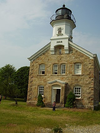
Sheffield Island Light is a historic lighthouse located at the southern end of the Norwalk Islands in Norwalk, Connecticut. It marks the west side of the mouth of the Norwalk River on northern Long Island Sound.

The Rose Island Light, built in 1870, is on Rose Island in Narragansett Bay in Newport, Rhode Island in the United States. It is preserved, maintained and operated by The Rose Island Lighthouse Foundation.

The Newport Harbor Light, also known as the Goat Island Light or Green Light, built in 1842, is located on north end of Goat Island, which is part of the city of Newport, Rhode Island, United States, in Narragansett Bay. The light was added to the National Register of Historic Places in 1988.

Great Captain Island Lighthouse is a lighthouse on Great Captain Island in the western Long Island Sound off the coast of Greenwich, Connecticut, United States. Built in 1829, the first lighthouse, made of stone, was of such poor construction that the walls were severely cracked a decade later. In 1868, a new granite dwelling with attached lantern was completed. The lighthouse is of the same design as lighthouses at Sheffield Island in Norwalk; Morgan Point in Noank; Old Field Point Light and Plum Island in New York; and Block Island North in Rhode Island. In 1890, a fog whistle was added, in 1905 a siren was installed. The lighthouse was deactivated in 1970 when a skeletal tower replaced it. The Town of Greenwich acquired the property in 1973 and had full-time caretakers on the site until the lighthouse became too dilapidated in 2003. A successful restoration effort was completed in 2009 and a non-navigational light was activated in 2012. In 2010, a memorial plaque was installed to "honor the 23 people who lived in Greenwich, or had a connection to the town", who died in the September 11, 2001 attacks. In 1991, the Great Captain Island Light was added to the National Register of Historic Places.

The Lynde Point Light or Lynde Point Lighthouse, also known as Saybrook Inner Lighthouse, is a lighthouse in Connecticut, United States, on the west side of the mouth of the Connecticut River on the Long Island Sound, Old Saybrook, Connecticut. The first light was a 35 feet (11 m) wooden tower constructed by Abisha Woodward for $2,200 and it was completed in 1803. A new lighthouse was eventually needed and a total of $7,500 was appropriated on July 7, 1838. Jonathan Scranton, Volney Pierce, and John Wilcox were contracted to build the new 65-foot (20 m) octagonal brownstone tower. It was constructed in 1838 and lit in 1839. The lighthouse was renovated in 1867 and had its keeper's house from 1833 replaced in 1858 with a Gothic Revival gambrel-roofed wood-frame house. In 1966, the house was torn down and replaced by a duplex house. The original ten lamps were replaced in 1852 with a fourth-order Fresnel lens, and with a fifth-order Fresnel lens in 1890. Lynde Point Lighthouse used whale oil until 1879 when it switched to kerosene. It was electrified in 1955 and fully automated by the United States Coast Guard in 1978. In 1990, it was added to the National Register of Historic Places and is significant for its "superior stone work in the tapering brownstone walls".
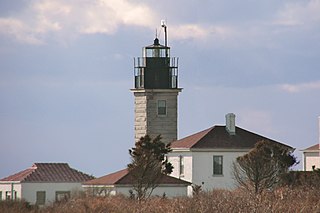
Beavertail Lighthouse was built in 1856 and is the premier lighthouse in Rhode Island, marking the entrance to Narragansett Bay. The 64-foot (20 m) lighthouse lies on the southernmost point of Conanicut Island in the town of Jamestown, Rhode Island in Beavertail State Park, on a site where beacons have stood since the early 18th century. The light provides navigation for boats and ships entering Narragansett Bay in the East Passage between Conanicut Island and Newport, Rhode Island on Aquidneck Island. Other lighthouses are visible from Beavertail Lighthouse, such as Castle Hill Lighthouse, Point Judith Light, and Rose Island Light.

Castle Hill Lighthouse is located on Narragansett Bay in Newport, Rhode Island at the end of the historic Ocean Drive. It is an active navigation aid for vessels entering the East Passage, between Conanicut Island and Aquidneck Island. The lighthouse has become a symbol of Newport, and a frequent site for wedding photos, proposals, and tourist photos. Although the property is owned by the nearby Castle Hill Inn, the lighthouse is owned by the United States Coast Guard.

The Providence River is a tidal river in the U.S. state of Rhode Island. It flows approximately 8 miles (13 km). There are no dams along the river's length, although the Fox Point Hurricane Barrier is located south of downtown to protect the city of Providence from damaging tidal floods.

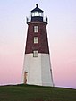
The Prudence Island Lighthouse, more commonly known locally as the Sandy Point Lighthouse, is located on Prudence Island, Rhode Island and is the oldest lighthouse tower in the state. Sandy Point is nicknamed Chibacoweda, meaning "little place separated by a passage", because the location is a little more than one mile offshore.
Bristol Ferry Light is a historic lighthouse in Bristol, Rhode Island, United States. It is located on the shores of Narragansett Bay at Bristol Point, the northern land point of Mount Hope Bay at the base of the Mount Hope Bridge.

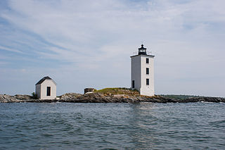
Conanicut Island Light, built in 1886, is an inactive lighthouse in Jamestown, Rhode Island.

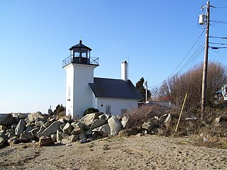
Sakonnet Light, built in 1884, is a sparkplug lighthouse near Sakonnet Point, Little Compton, Rhode Island, on the eastern side of the state.

Poplar Point Light (Lighthouse), built in 1831, is an historic lighthouse in North Kingstown, Rhode Island. It stands at the end of Poplar Point, marking the southern point of Wickford Harbor. The lighthouse was built in 1831 with a stone keeper's dwelling and wooden tower. The light was deactivated in 1882 and replaced by the Wickford Harbor Light. It was sold at auction in 1894 and has been altered by later owners. The lighthouse was listed on the National Register of Historic Places in 1988. The tower is the oldest surviving wooden lighthouse tower in the United States, and the oldest in Rhode Island still standing at its original location.
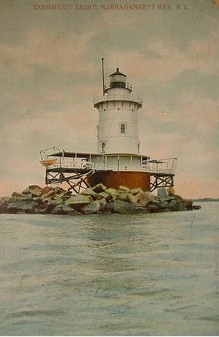
Conimicut Light, built in 1883, is a historic sparkplug lighthouse in Warwick, Rhode Island. The lighthouse was listed on the National Register of Historic Places in 1988. The lighthouse is said to be in "relatively good condition."

Warwick Light, also known as Warwick Lighthouse, is an historic lighthouse in Warwick, Rhode Island, United States.
Dutch Island Light is a historic lighthouse on Dutch Island off Jamestown, Rhode Island.

The Squantum Association is a private club in East Providence, Rhode Island on 947 Veterans Memorial Parkway. Its main Club House overlooks the Providence River on a rocky promontory. This Colonial Revival building was constructed in 1900 by Martin & Hall and added to the National Register of Historic Places in 1980. The brick bakehouse was built in 1899 and has weathered numerous hurricanes from its lofty perch right on the rocky coast. The "Cottage" is the oldest building on the property and was originally built as a billiard hall. Also surviving from the 19th century is the club office, formerly the manager's residence.

The Benjamin Aborn Jackson House is an historic house at 115 Nayatt Road in Barrington, Rhode Island. The 2+1⁄2-story brick house was designed by architect Norman M. Isham and completed in 1913 for Benjamin Aborn Jackson, a Rhode Island banking and railroad executive. The house is a rare survivor of the development of Nayatt Point as a resort area. The L-shaped building is set well back from Nayatt Road, and is not far from the Nayatt Point Light.