
Narragansett is a town in Washington County, Rhode Island, United States. The population was 14,532 at the 2020 census. However, during the summer months the town's population more than doubles to near 34,000. The town of Narragansett occupies a narrow strip of land running along the eastern bank of the Pettaquamscutt River to the shore of Narragansett Bay. It was separated from South Kingstown in 1888 and incorporated as a town in 1901.

Wakefield is a village in the town of South Kingstown, Rhode Island, United States, and the commercial center of South Kingstown. Together with the village of Peace Dale, it is treated by the U.S. Census as a component of the census-designated place identified as Wakefield-Peacedale, Rhode Island. West Kingston, another South Kingstown village, was the traditional county seat of Washington County. Since 1991, the Washington County Courthouse has been in Wakefield. The Sheriff's Office which handles corrections is also in Wakefield.

Wickford is a small village in the town of North Kingstown, Rhode Island, United States, which is named after Wickford in Essex, England. Wickford is located on the west side of Narragansett Bay, just about a 20-minute drive across two bridges from Newport, Rhode Island. The village is built around one of the most well-protected natural harbors on the eastern seaboard, and features one of the largest collections of 18th century dwellings to be found anywhere in the northeast. Today the majority of the village's historic homes and buildings remain largely intact upon their original foundations.

Saunderstown is a small village and historic district in the towns of Narragansett and North Kingstown in Washington County, Rhode Island, United States. Saunderstown has its own post office with the ZIP Code of 02874, which also includes a small part of South Kingstown. Its population is 6,245.

The Blackstone Canal was a waterway linking Worcester, Massachusetts, to Providence, Rhode Island through the Blackstone Valley via a series of locks and canals during the early 19th century.

The Washington–Rochambeau Revolutionary Route is a 680-mile (1,090 km) series of roads used in 1781 by the Continental Army under the command of George Washington and the Expédition Particulière under the command of Jean-Baptiste de Rochambeau during their 14-week march from Newport, Rhode Island, to Yorktown, Virginia. 4,000 French and 3,000 American soldiers began the march.

Saylesville is a village and historic district in Lincoln, Rhode Island.

The Windmill Hill Historic District is a historic district encompassing a large rural landscape in Jamestown, Rhode Island. It is bounded on the north by Eldred Avenue, on the east by East Shore Road, on the south by Great Creek, and on the west by Narragansett Bay. The area's historical resources included six farmsteads, as well as the Quaker Meetinghouse, the Jamestown Windmill, and its associated miller's house and barn. The area is predominantly rolling hills with open pastureland and forest. The district was listed on the National Register of Historic Places in 1978. The area is also rich in prehistoric evidence of Native American occupation, which is the subject of the Jamestown Archeological District listing on the National Register.

Miantonomi Memorial Park is a public park between Hillside Avenue and Girard Avenue in Newport, Rhode Island.

The Edgewood Historic District–Taft Estate Plat is a historic district in Cranston, Rhode Island that is bounded by Windsor Road, Narragansett Bay, Circuit Drive and Broad Street. The district represents the final subdivision of a country estate amassed by industrialist Orray Taft (1793-1865). It was laid out in 1904 and most of its residential stock was built between 1905 and 1930. The average size of the lots was 5400 square feet, although there was some variance in size, and a one-acre plot was reserved for the Taft mansion. The houses are architecturally heterogeneous, reflecting all of the major styles of the period; some properties were designed by Norman Isham.

The Reservoir Avenue Sewage Pumping Station is an historic wastewater pumping facility on the south side of the junction of Reservoir and Pontiac Avenues in southern Providence, Rhode Island. From the street it looks like a single-story brick structure with a hip roof, and metal doorways on its north and east elevations. This building stands atop a substantial concrete substructure, which houses a dry well and wet well. The dry well, on the eastern side, houses the pumps, while the wet well, occupies the western two-thirds of the facility. The floor of the interior includes glass blocks for viewing the facilities below, as well as metal trapdoors for accessing the pumps. Manual gate valves on the west side are used to control sewage flow through the west well. This facility is used to pump raw sewage eastward and uphill to a gravity conduit in Rutherglen Avenue. This conduit carries the sewage to the Field's Point treatment facility. The pumping station was built by the city of Providence in 1931, and is now owned by the Narragansett Bay Commission, which operates the region's wastewater treatment facilities.

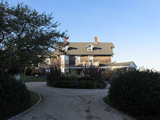
Druidsdream is a historic house at 144 Gibson Avenue in Narragansett, Rhode Island. It is a 2-1/2 story stone structure, completed in 1884. It was built, probably by predominantly Narragansett stonemasons, for Joseph Hazard, a locally prominent landowner and botanist. It has a cross gable plan, with its main facade divided into three bays, looking south over landscaped grounds. The central bay has a slightly-projecting pavilion, with the second floor bays filled with French doors and iron railings.

Earlscourt Historic District is a residential historic district in Narragansett, Rhode Island, United States. It is centered on a stretch of Earles Court, between Gibson Avenue and Noble Street, and includes a few properties on the adjacent Gibson Avenue and Woodward and Westminster Streets. It includes nine residential properties developed in the 1880s and 1890s, during the height of Narragansett Pier's popularity as a summer resort community. All are in the then-popular Shingle Style, and most were designed by well-known architects. The Sherry Cottages, a series of four buildings on Gibson Avenue, were all designed by McKim, Mead & White, who also designed The Towers. The other development is that on Earles Court, designed by D. J. Jardine and Constable Brothers for Edward Earle, a New York lawyer. The central focus of this development is a stone water tower which bisects the roadway.

For the Gardencourt Historic District is Louisville Kentucky see Cherokee-Seneca, Louisville
The Ocean Road Historic District is a residential historic district, encompassing an area of fashionable summer houses built in the late 19th and early 20th centuries in Narragansett, Rhode Island. The area is located south of The Towers, the center of the Narragansett Pier area, extending along Ocean Road roughly from Hazard Street to Wildfield Farm Road. Many of the 45 houses in the district were built between about 1880 and 1900, with a few built earlier and later. The Shingle style is prominent in the architectural styles found, including among houses designed by architects, including McKim, Mead & White and William Gibbons Preston. The most unusual property is called Hazard's Castle, a rambling stone structure built beginning in the 1840s by Joseph Peace Hazard, who was a major landowner in the area prior to its development in the 1880s.

St. Paul's Church is a historic church at 55 Main Street in the village of Wickford within the town of North Kingstown, Rhode Island. It is a single-story Romanesque Revival structure, designed by Rhode Island architect Thomas Tefft and built in 1847. Its main rectangular block has a gable roof, and narrow round-arch windows on the side walls with molded surrounds. The front of the church is asymmetrical, with the tower on the left and its entry slightly off-center between the tower and a small projecting narthex area. The square tower has single narrow round-arch windows on the first level, paired round-arch windows on the second, and clock faces on the third. A roof skirt rises to an open octagonal belfry, which is capped by a steeple and spire.

The Towers Historic District is a historic district in Narragansett, Rhode Island, encompassing a city block bounded by the Atlantic Ocean, Exchange Place, Mathewson and Taylor Streets. It is centered on The Towers, the surviving remnant of the Narragansett Casino, built 1883-86 to a design by McKim, Mead & White. This area was always near the center of resort-oriented development in Narragansett from the mid-19th century on, including four summer cottages on Taylor and Mathewson Streets built in the 1860s and 1870s. Most of the casino was destroyed by fire in 1900, leaving its stone towers, and the nearby Coast Guard station, also designed by McKim, Mead & White. The oldest building in the district is an 1822 2+1⁄2-story house at 18 Mathewson Street.

The Edgewood Historic District–Shaw Plat is a residential historic district in the Edgewood neighborhood of northeastern Cranston, Rhode Island. It is bounded by Broad Street on the west, Marion Avenue on the south, and Narragansett Bay on the east; it consists of the properties that line the parallel streets, Shaw and Marion Avenues, and the short section of Narragansett Boulevard that runs between Shaw and Marion Avenues. On the north, it abuts the separately-listed Edgewood Historic District–Arnold Farm Plat. The area was platted out between 1867 and 1895, with the construction of most of its housing taking place between 1867 and the start of World War II, with the most construction going on between 1895 and 1930. The district also includes the previously listed Edgewood Yacht Club. In 1853, the 25 acres of land that became the Shaw Plat was sold to Allen Shaw of Providence for $3,660.

The Edgewood Historic District–Arnold Farm Plat is a residential historic district in the Edgewood neighborhood of eastern Cranston, Rhode Island. It is bounded on the north by Albert Avenue, on the east by Narragansett Bay, on the south by Columbia Avenue, and on the west by Broad Street. The district was primarily built out as a streetcar suburb of Providence between 1890 and 1930, and feature styles from Queen Anne and Colonial Revival to Dutch Colonials and two- and three-decker multiunit houses. Prior to its development, the area had been farmed by several generations of the Arnold family.

The Edgewood Historic District–Anstis Greene Estate Plat is a residential historic district in the Edgewood neighborhood of eastern Cranston, Rhode Island. The 34-acre (14 ha) area is bounded on the west by Broad Street, the east by Narragansett Bay, the south by Rosewood Avenue, and on the north by Marion Avenue, where it abuts the Edgewood Historic District-Shaw Plat. The area, originally part of a much larger property belonging to Zachariah Rhodes in the 17th century, was platted for residential development in the decades following the arrival of the streetcar on Broad Street, providing commuter service to Providence. The land was willed by Anstis Rhodes Greene to a group of heirs, who progressively developed their individual portions. The only significant surviving elements that predate this development are two small family cemeteries.


