
Wakefield is a village in the town of South Kingstown, Rhode Island, United States, and the commercial center of South Kingstown. Together with the village of Peace Dale, it is treated by the U.S. Census as a component of the census-designated place identified as Wakefield-Peacedale. West Kingston, another South Kingstown village, was the traditional county seat of Washington County. Since 1991, the Washington County Courthouse has been in Wakefield. The Sheriff's Office which handles corrections is also in Wakefield.

Wickford is a small village in the town of North Kingstown, Rhode Island, United States, which is named after Wickford in Essex, England. Wickford is located on the western side of Narragansett Bay, just about a 20-minute drive across two bridges from Newport, Rhode Island. The village is built around one of the most well-protected natural harbors on the eastern seaboard, and features one of the largest collections of 18th century dwellings to be found anywhere in the Northeast. Today, the majority of the village's historic homes and buildings remain largely intact upon their original foundations.

Saunderstown is a small village and historic district in the towns of Narragansett and North Kingstown in Washington County, Rhode Island, United States. It was named in honor of John Aldrich Saunders, a member of the Saunders family. Saunderstown has its own post office with the ZIP Code of 02874, which also includes a small part of South Kingstown. Its population is 6,245.

The Newport Harbor Light, also known as the Goat Island Light or Green Light, built in 1842, is located on north end of Goat Island, which is part of the city of Newport, Rhode Island, United States, in Narragansett Bay. The light was added to the National Register of Historic Places in 1988.
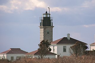
Beavertail Lighthouse was built in 1856 and is the premier lighthouse in Rhode Island, marking the entrance to Narragansett Bay. The 64-foot (20 m) lighthouse lies on the southernmost point of Conanicut Island in the town of Jamestown, Rhode Island in Beavertail State Park, on a site where beacons have stood since the early 18th century. The light provides navigation for boats and ships entering Narragansett Bay in the East Passage between Conanicut Island and Newport, Rhode Island on Aquidneck Island. Other lighthouses are visible from Beavertail Lighthouse, such as Castle Hill Lighthouse, Point Judith Light, and Rose Island Light.

The Naval War College Museum in Newport, Rhode Island, is one of 10 official American museums operated by the United States Navy, under the direction of the Naval History & Heritage Command and in co-operation with the Naval War College. It is located at Building 10, Luce Avenue, Naval Station Newport. It is located in the building which first housed the Naval War College, a structure built in the early 19th century to house Newport's poor. The building is a contributing element to a National Historic Landmark District, along with Luce Hall, the college's first purpose-built building, in recognition of the War College's historical significance.

Smith's Castle, built in 1678, is a house museum at 55 Richard Smith Drive, near Wickford, a village in North Kingstown, Rhode Island. Smith's Castle is one of the oldest houses in the state. It was designated a National Historic Landmark in 1993 as Cocumscussoc Archeological Site due to the artifacts and information that digs have yielded in the area. It is located just off U.S. Route 1 in Rhode Island.

This is a list of the National Register of Historic Places listings in Kent County, Rhode Island.
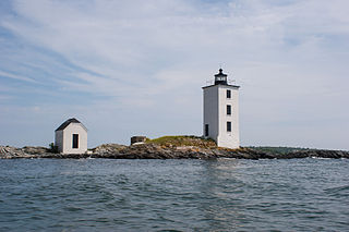
Bristol Ferry Light is a historic lighthouse in Bristol, Rhode Island, United States. It is located on the shores of Narragansett Bay at Bristol Point, the northern land point of Mount Hope Bay at the base of the Mount Hope Bridge.

The Windmill Hill Historic District is a historic district encompassing a large rural landscape in Jamestown, Rhode Island. It is bounded on the north by Eldred Avenue, on the east by East Shore Road, on the south by Great Creek, and on the west by Narragansett Bay. The area's historical resources included six farmsteads, as well as the Quaker Meetinghouse, the Jamestown Windmill, and its associated miller's house and barn. The area is predominantly rolling hills with open pastureland and forest. The district was listed on the National Register of Historic Places in 1978. The area is also rich in prehistoric evidence of Native American occupation, which is the subject of the Jamestown Archeological District listing on the National Register.
The Wreck Sites of HMS Cerberus and HMS Lark are located in the waters of Narragansett Bay on the west side of Aquidneck Island near South Portsmouth, Rhode Island.
The Jamestown Archeological District is an expansive archaeological district which is the site of a major prehistoric Native American settlement in Jamestown, Rhode Island. The full extent of archaeologically-sensitive areas has not been fully identified, but is known to extend from Narragansett Avenue in the south to Rhode Island Route 138 in the north, and from Narragansett Bay in the west to North Road. The district overlaps the historically significant Windmill Hill Historic District, and the nearly 300-acre (120 ha) Watson Farm. The district includes one of largest Native American burying grounds in New England, and includes evidence of occupation dating to 3,000 BC.
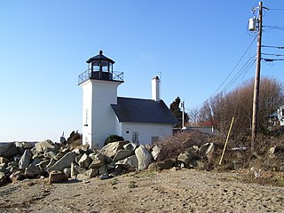
Dutch Island Light is a historic lighthouse on Dutch Island off Jamestown, Rhode Island.

Old Narragansett Church is a historic Episcopal church located at 60 Church Lane in Wickford, Rhode Island, believed to be the oldest Episcopal church building in the Northeastern United States.

The Crowfield Historic District is a small residential historic district in North Kingstown, Rhode Island. It encompasses a cluster of four early 20th-century summer houses, all connected via family or friendship connections to the writer Owen Wister. The occupy a large parcel of land sloping down to the shore of Narragansett Bay on the east side of Boston Neck Road, a short way north of the Jamestown Verrazzano Bridge. The area was named "Crowfield" by Elizabeth Middleton Cope, who built a Shingle-style mansion in 1906. Owen Wister, her uncle, built his house, Champ de Corbeau, in 1909-10 to a design by Grant Lafarge. The Jamieson House was also built in 1906, and was designed by the same architect, James P. Jamieson. The fourth house, Orchard House, was built in 1924. All are Shingle style houses. The compound is unusual for North Kingstown, where most summer estates were isolated individual properties.

Fort Ninigret is a historic fort and trading post site at Fort Neck Road in Charlestown, Rhode Island, built and occupied by European settlers in the seventeenth century. At its 1883 dedication, Commissioner George Carmichael, Jr. referred to it as "the oldest military post on the Atlantic coast."

The Benjamin Aborn Jackson House is an historic house at 115 Nayatt Road in Barrington, Rhode Island. The 2+1⁄2-story brick house was designed by architect Norman M. Isham and completed in 1913 for Benjamin Aborn Jackson, a Rhode Island banking and railroad executive. The house is a rare survivor of the development of Nayatt Point as a resort area. The L-shaped building is set well back from Nayatt Road, and is not far from the Nayatt Point Light.

Rosedale Apartments are a historic apartment house at 1180 Narragansett Boulevard in Cranston, Rhode Island. This U-shaped apartment block stands overlooking Narragansett Bay, with three stories facing the street and four toward the bay. The Art Moderne structure was designed by Herbert R. Hunt and built in 1939–40. It is a rare statewide example of a large-scale building in this style, and was one of only a few built in Cranston before the Second World War.

The Edgewood Historic District–Arnold Farm Plat is a residential historic district in the Edgewood neighborhood of eastern Cranston, Rhode Island. It is bounded on the north by Albert Avenue, on the east by Narragansett Bay, on the south by Columbia Avenue, and on the west by Broad Street. The district was primarily built out as a streetcar suburb of Providence between 1890 and 1930, and feature styles from Queen Anne and Colonial Revival to Dutch Colonials and two- and three-decker multiunit houses. Prior to its development, the area had been farmed by several generations of the Arnold family.
List of Registered Historic Places in West Greenwich, Rhode Island, which has been transferred from and is an integral part of National Register of Historic Places listings in Kent County, Rhode Island


