The Towers (Narragansett, Rhode Island)

Last updated

The Towers
Narragansett Towers intersection 2008.jpg
USA Rhode Island location map.svg
Red pog.svg
Usa edcp location map.svg
Red pog.svg
Location35 Ocean Road, Narragansett, Rhode Island, U.S.
Coordinates 41°25′50″N71°27′22″W / 41.43056°N 71.45611°W / 41.43056; -71.45611
Built1883
Architect McKim, Mead, and White
Part of Towers Historic District (ID82000021)
NRHP reference No. 69000001 [1]
Significant dates
Added to NRHPNovember 25, 1969
Designated CPAugust 18, 1982

The Towers is a historic structure located at 35 Ocean Road in Narragansett, Rhode Island. It is the only remnant of the Narragansett Pier Casino built in the 1880s. On November 25, 1969, it was added to the National Register of Historic Places.

Contents

History (1883–1900)

The Narragansett Pier Casino was the center of social life in Narragansett during the late 19th century. The Narragansett Pier Casino rivaled the Newport Casino’s popularity as a resort for the social elite until it burned to the ground in 1900.

Built between 1883–1886, the Narragansett Pier Casino was a fine example of Victorian Shingle style architecture (a variation of Queen Anne style architecture in the United States), designed by McKim, Mead, and White. The Casino offered a variety of sports, including boating, tennis, billiards, bowling, cards, and shooting, restaurants, stores, reading rooms, a theater, a bandstand, a ballroom, and a beautiful beach. [2]

The Narragansett Pier Casino thrived during the Gilded Age until it burned down during the Great Fire of September 12, 1900. That day, a fire broke out in the neighboring Rockingham Hotel. The flames spread quickly to the Casino, leaving only the granite walls of The Towers standing. More recently Hurricane Sandy has uncovered the foundation and part of the old boardwalk belonging to the old casino that had been buried by sand.

Recent history

Today, the Narragansett Towers are the only remaining part of the original Narragansett Pier Casino, having survived a number of fires, nor'easters, and hurricanes. one of the most recognizable landmarks in Narragansett. The Towers currently hosts weddings, dances, dinners, plays, and fashion shows. Its location adjacent to Narragansett town beach makes it an ideal venue for social events.
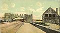
Many events take place on the land adjacent to The Towers, as well as the land next door, where the Casino once stood, that now includes a lawn and a courtyard with a fountain. Events such as The Blessing of the Fleet road race and festival, local art festivals, the Lighting of the town Christmas tree, and many beautiful weddings.

The Casino at the Narragansett Towers is also the location of the first reports of the now-popular seafood dish "clams casino."

The Towers can be seen in the background of the Rhode Island-based cartoon Family Guy , episode "Peter's Got Woods," when Peter rides by on a tandem bicycle with James Woods, both engaged in song.

See also

Related Research Articles

<span class="mw-page-title-main">Narragansett, Rhode Island</span> Town in Rhode Island, United States

Narragansett is a town in Washington County, Rhode Island, United States. The population was 14,532 at the 2020 census. However, during the summer months the town's population more than doubles to near 34,000. The town of Narragansett occupies a narrow strip of land running along the eastern bank of the Pettaquamscutt River to the shore of Narragansett Bay. It was separated from South Kingstown in 1888 and incorporated as a town in 1901.

<span class="mw-page-title-main">Prudence Island</span>

Prudence Island is the third-largest island in Narragansett Bay in the state of Rhode Island and part of the town of Portsmouth, Rhode Island, United States. It is located near the geographic center of the bay. It is defined by the United States Census Bureau as Block Group 3, Census Tract 401.03 of Newport County, Rhode Island. As of the 2010 census, the population was 278 people living on a land area of 14.43 km2.

<span class="mw-page-title-main">Jersey Shore</span> Coastal region of the U.S. state of New Jersey

The Jersey Shore is the coastal region of the U.S. state of New Jersey. Geographically, the term encompasses about 141 miles (227 km) of oceanfront bordering the Atlantic Ocean, from Perth Amboy in the north to Cape May Point in the south. The region includes Middlesex, Monmouth, Ocean, Atlantic, and Cape May counties, which are in the central and southern parts of the state. Located in the center of the Northeast Megalopolis, the northern half of the shore region is part of the New York metropolitan area, while the southern half of the shore region is part of the Philadelphia metropolitan area, also known as the Delaware Valley. The Jersey Shore hosts the highest concentration of oceanside boardwalks in the United States.

<span class="mw-page-title-main">Wakefield, Rhode Island</span> Village in Rhode Island, United States

Wakefield is a village in the town of South Kingstown, Rhode Island, United States, and the commercial center of South Kingstown. Together with the village of Peace Dale, it is treated by the U.S. Census as a component of the census-designated place identified as Wakefield-Peacedale, Rhode Island. West Kingston, another South Kingstown village, was the traditional county seat of Washington County. Since 1991, the Washington County Courthouse has been in Wakefield. The Sheriff's Office which handles corrections is also in Wakefield.

<span class="mw-page-title-main">Peace Dale, Rhode Island</span> United States historic place

Peace Dale is a village in the town of South Kingstown, Rhode Island. Together with the village of Wakefield, it is treated by the U.S. Census as a component of the census-designated place identified as Wakefield-Peacedale, Rhode Island.

Watch Hill is an affluent coastal neighborhood and census-designated place in the town of Westerly, Rhode Island. The population was 154 at the 2010 census. It sits at the most-southwestern point in Rhode Island. It came to prominence in the late 19th and early 20th century as an exclusive summer resort, with wealthy families building sprawling Victorian-style "cottages" along the peninsula. Watch Hill is characterized by The New York Times as a community "with a strong sense of privacy and of discreetly used wealth," in contrast with "the overpowering castles of the very rich" in nearby Newport.

<span class="mw-page-title-main">Wickford, Rhode Island</span> Village in North Kingstown, Rhode Island, US

Wickford is a small village in the town of North Kingstown, Rhode Island, United States, which is named after Wickford in Essex, England. Wickford is located on the west side of Narragansett Bay, just about a 20-minute drive across two bridges from Newport, Rhode Island. The village is built around one of the most well-protected natural harbors on the eastern seaboard, and features one of the largest collections of 18th century dwellings to be found anywhere in the Northeast. Today the majority of the village's historic homes and buildings remain largely intact upon their original foundations.

<span class="mw-page-title-main">Beavertail Lighthouse</span> United States historic place

Beavertail Lighthouse was built in 1856 and is the premier lighthouse in Rhode Island, marking the entrance to Narragansett Bay. The 64-foot (20 m) lighthouse lies on the southernmost point of Conanicut Island in the town of Jamestown, Rhode Island in Beavertail State Park, on a site where beacons have stood since the early 18th century. The light provides navigation for boats and ships entering Narragansett Bay in the East Passage between Conanicut Island and Newport, Rhode Island on Aquidneck Island. Other lighthouses are visible from Beavertail Lighthouse, such as Castle Hill Lighthouse, Point Judith Light, and Rose Island Light.

<span class="mw-page-title-main">Charles I. D. Looff</span> Danish carver and amusement park ride builder

Charles I. D. Looff was a Danish master carver and builder of hand-carved carousels and amusement rides, who immigrated to the United States of America in 1870. Looff built the first carousel at Coney Island in 1876. During his lifetime, he built over 40 carousels, several amusements parks, numerous roller coasters and Ferris wheels, and built California's famous Santa Monica Pier. He became famous for creating the unique Coney Island style of carousel carving.

<span class="mw-page-title-main">Kingston station (Rhode Island)</span> Railway station in Kingston, Rhode Island

Kingston is a historic railroad station located on the Northeast Corridor in the village of West Kingston, in the town of South Kingstown, Rhode Island. It was built at this location in 1875 by the New York, Providence and Boston Railroad, replacing earlier stations dating back to the opening of the line in 1837. Current rail services consist of Northeast Regional trains in each direction, most of which stop at the station. Historically Kingston provided commuter rail service to Providence and Boston via Amtrak's commuter rail services. The MBTA is looking at extending their commuter service on the Providence/Stoughton Line.

<span class="mw-page-title-main">Earlscourt Historic District</span> Historic district in Rhode Island, United States

Earlscourt Historic District is a residential historic district in Narragansett, Rhode Island, United States. It is centered on a stretch of Earles Court, between Gibson Avenue and Noble Street, and includes a few properties on the adjacent Gibson Avenue and Woodward and Westminster Streets. It includes nine residential properties developed in the 1880s and 1890s, during the height of Narragansett Pier's popularity as a summer resort community. All are in the then-popular Shingle Style, and most were designed by well-known architects. The Sherry Cottages, a series of four buildings on Gibson Avenue, were all designed by McKim, Mead & White, who also designed The Towers. The other development is that on Earles Court, designed by D. J. Jardine and Constable Brothers for Edward Earle, a New York lawyer. The central focus of this development is a stone water tower which bisects the roadway.

<span class="mw-page-title-main">Dunmere (Narragansett, Rhode Island)</span> Historic house in Rhode Island, United States

Dunmere is a historic estate at 560 Ocean Road in Narragansett, Rhode Island.

<span class="mw-page-title-main">Gardencourt</span> Historic house in Rhode Island, United States

Gardencourt is an historic home at 10 Gibson Avenue in Narragansett, Rhode Island.

<span class="mw-page-title-main">Greene Inn</span> United States historic place

The Greene Inn was a historic summer resort hotel at 175 Ocean Road in Narragansett, Rhode Island.

<span class="mw-page-title-main">Narragansett Pier Life Saving Station</span> Historic building in Rhode Island, US

The Coast Guard House is an historic lifesaving station at 40 Ocean Road in Narragansett, Rhode Island.

<span class="mw-page-title-main">Ocean Road Historic District</span> Historic district in Rhode Island, United States

The Ocean Road Historic District is a residential historic district, encompassing an area of fashionable summer houses built in the late 19th and early 20th centuries in Narragansett, Rhode Island. The area is located south of The Towers, the center of the Narragansett Pier area, extending along Ocean Road roughly from Hazard Street to Wildfield Farm Road. Many of the 45 houses in the district were built between about 1880 and 1900, with a few built earlier and later. The Shingle style is prominent in the architectural styles found, including among houses designed by architects, including McKim, Mead & White and William Gibbons Preston. The most unusual property is called Hazard's Castle, a rambling stone structure built beginning in the 1840s by Joseph Peace Hazard, who was a major landowner in the area prior to its development in the 1880s.

<span class="mw-page-title-main">Towers Historic District</span> Historic district in Rhode Island, United States

The Towers Historic District is a historic district in Narragansett, Rhode Island, encompassing a city block bounded by the Atlantic Ocean, Exchange Place, Mathewson and Taylor Streets. It is centered on The Towers, the surviving remnant of the Narragansett Casino, built 1883-86 to a design by McKim, Mead & White. This area was always near the center of resort-oriented development in Narragansett from the mid-19th century on, including four summer cottages on Taylor and Mathewson Streets built in the 1860s and 1870s. Most of the casino was destroyed by fire in 1900, leaving its stone towers, and the nearby Coast Guard station, also designed by McKim, Mead & White. The oldest building in the district is an 1822 2+12-story house at 18 Mathewson Street.

Crescent Park was an amusement park in Riverside, East Providence, Rhode Island which ran from 1886 to 1979. The park was known for its Rhode Island Shore Dinners, the Alhambra Ballroom and its midway.

<span class="mw-page-title-main">Willard Kent</span> American architect

Willard Kent (1851–1924) was an architect and engineer of Woonsocket, Rhode Island.

St. Thomas More Parish includes both St. Thomas More Church and St. Veronica Chapel, both located in Narragansett, Rhode Island. Father Marcel Taillon is the pastor.

References

  1. "National Register Information System". National Register of Historic Places . National Park Service. January 23, 2007.
  2. "Our Past". The Towers. Retrieved October 21, 2014.