Providence County is the most populous county in the U.S. state of Rhode Island. As of the 2020 census, the county's population was 660,741, or 60.2% of the state's population. Providence County contains the city of Providence, the state capital of Rhode Island and the county's most populous city, with an estimated 190,934 residents in 2020. Providence County is included in the Providence-Warwick, RI-MA Metropolitan Statistical Area, which in turn constitutes a portion of the greater Boston-Worcester-Providence, MA-RI-NH-CT Combined Statistical Area. As of 2010, the center of population in Rhode Island is located in Providence County, in the city of Cranston.

Newport County is one of five counties located in the U.S. state of Rhode Island. As of the 2020 census, the population was 85,643. It is also one of the seven regions of Rhode Island. The county was created in 1703. Like all of the counties in Rhode Island, Newport County no longer has any governmental functions. All of those functions in Rhode Island are now carried out by the state government, or by the cities and towns of Rhode Island. Newport County is included in the Providence-Warwick, RI-MA Metropolitan Statistical Area, which is in turn constitutes a portion of the greater Boston-Worcester-Providence, MA-RI-NH-CT Combined Statistical Area.

Kent County is a county located in the U.S. state of Rhode Island. As of the 2020 census, the population was 170,363, making it the second-most populous county in Rhode Island. The county was formed in 1750 from the southern third of Providence County. It was named after the county of Kent, England. Kent County, like other counties in Rhode Island, no longer has governmental functions. Its seat is East Greenwich. Kent County is included in the Providence-Warwick, RI-MA Metropolitan Statistical Area, which in turn constitutes a portion of the greater Boston-Worcester-Providence, MA-RI-NH-CT Combined Statistical Area.

Bristol County is a county located in the U.S. state of Rhode Island. As of the 2020 census, the population was 50,793, making it the least populous county in Rhode Island. In terms of land area, it is the third-smallest county in the United States, at only 25 square miles (65 km2). The county was created in 1747 when it was separated from Bristol County, Massachusetts. Bristol County is included in the Providence-Warwick, RI-MA Metropolitan Statistical Area, which in turn constitutes a portion of the greater Boston-Worcester-Providence, MA-RI-NH-CT Combined Statistical Area.

Exeter Township is a township within the Greater Pittston area of Luzerne County, Pennsylvania, United States. The population was 2,047 at the 2020 census. Upper Exeter and Harding are two villages in the township.

Coventry is a town in Kent County, Rhode Island, United States. The population was 35,688 at the 2020 census and is part of the Pawtuxet River Valley.

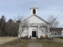
East Greenwich is a town and the county seat of Kent County, Rhode Island. The population was 14,312 at the 2020 census. East Greenwich is the wealthiest municipality within the state of Rhode Island. It is part of the Providence metropolitan statistical area and the Greater Boston combined statistical area.

West Greenwich is a town in Kent County, Rhode Island, United States. The population was 6,528 at the 2020 census. West Greenwich was named for the historic town of Greenwich, Kent, England. It was separated from East Greenwich in 1741. Students go to Exeter-West Greenwich Regional School in West Greenwich.
Glocester is a town in Providence County, Rhode Island, United States. The population was 9,974 as of the 2020 census. The villages of Chepachet and Harmony are in Glocester. Putnam Pike runs west through the town center of Glocester into Putnam, Connecticut.

Charlestown is a town in Washington County, Rhode Island, United States. The population was 7,997 at the 2020 census.
Hopkinton is a town in Washington County, Rhode Island, United States. The population was 8,398 at the 2020 census.

Narragansett is a town in Washington County, Rhode Island, United States. The population was 14,532 at the 2020 census. However, during the summer months the town's population more than doubles to near 34,000. The town of Narragansett occupies a narrow strip of land running along the eastern bank of the Pettaquamscutt River to the shore of Narragansett Bay on the Atlantic Ocean. It was separated from South Kingstown in 1888 and incorporated as a town in 1901. With several ocean beaches and a walkable strip along the ocean front, Narragansett is a resort area in the summer season as well as a popular East Coast surfing spot due to frequent southerly swells from Atlantic Ocean.

North Kingstown is a town in Washington County, Rhode Island, United States, and is part of the Providence metropolitan area. The population was 27,732 in the 2020 census. North Kingstown is home to the birthplace of American portraitist Gilbert Stuart, who was born in the village of Saunderstown. Within the town is Quonset Point, location of the former Naval Air Station Quonset Point, known for the invention of the Quonset hut, as well as the historic village of Wickford.

Richmond is a town in Washington County, Rhode Island, United States. The population was 8,020 at the 2020 census. It contains the villages of Alton, Arcadia, Barberville, Carolina, Hillsdale, Kenyon, Shannock, Tug Hollow, Usquepaug, Wood River Junction, Woodville, and Wyoming. Students in Richmond are part of the Chariho Regional School District.

South Kingstown is a town in, and the county seat of, Washington County, Rhode Island, United States. The population was 31,931 at the 2020 census. South Kingstown is the second largest town in Rhode Island by total geographic area, behind New Shoreham, and the third largest town in Rhode Island by geographic land area, behind Exeter and Coventry.

Wakefield-Peacedale is a census-designated place (CDP) in the town of South Kingstown in Washington County, Rhode Island, United States that includes the villages of Peace Dale and Wakefield. The population was 8,487 at the 2010 census.

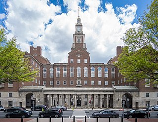
Kingston is a village and a census-designated place within the town of South Kingstown in Washington County, Rhode Island, United States, and the site of the main campus of the University of Rhode Island. The population was 6,974 at the 2010 census. Much of the village center is listed on the National Register of Historic Places as Kingston Village Historic District. It was originally known as Little Rest.
Carolina is a village that straddles the border of the towns of Charlestown and Richmond on the Pawcatuck River in Washington County, Rhode Island, United States. Rhode Island Route 112 passes through the village. Carolina is identified as a census-designated place, with a population of 970 at the 2010 census.

Wyoming is a village and census-designated place on the Wood River in southern Rhode Island, United States, primarily in the town of Richmond, but extending north across the river into the town of Hopkinton. The population was 270 at the 2010 census. It is the site of the Wyoming Village Historic District and a post office, assigned ZIP code 02898.

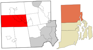
Washington County, known locally as South County, is a county located in the U.S. state of Rhode Island. As of the 2020 census, the population was 129,839. Rhode Island counties have no governmental functions other than as court administrative boundaries, which are part of the state government.