
Wakefield is a village in the town of South Kingstown, Rhode Island, United States, and the commercial center of South Kingstown. Together with the village of Peace Dale, it is treated by the U.S. Census as a component of the census-designated place identified as Wakefield-Peacedale, Rhode Island. West Kingston, another South Kingstown village, was the traditional county seat of Washington County. Since 1991, the Washington County Courthouse has been in Wakefield. The Sheriff's Office which handles corrections is also in Wakefield.

Peace Dale is a village in the town of South Kingstown, Rhode Island. Together with the village of Wakefield, it is treated by the U.S. Census as a component of the census-designated place identified as Wakefield-Peacedale, Rhode Island.

Slatersville is a village on the Branch River in the town of North Smithfield, Rhode Island, United States. It includes the Slatersville Historic District, a historic district listed on the National Register of Historic Places. The historic district has been included as part of the Blackstone River Valley National Historical Park. The North Smithfield Public Library is located in Slatersville.
Oakland is a village in Burrillville, Providence County, Rhode Island, United States. It was developed in the 19th century at the site of a stone mill near the confluence of the Chepachet and Clear Rivers. It is one of the few remaining stone mills in this state. Most of the village is included in the Oakland Historic District, a historic district listed on the National Register of Historic Places. Most of the housing in the village was originally built to house mill workers, although there are several more elaborate houses built for mill executives.

Saylesville is a village and historic district in Lincoln, Rhode Island.

The Jamestown Windmill is a smock mill in Jamestown, Rhode Island within the Windmill Hill Historic District on North Road north of Weeden Lane.

Arnold Mills Historic District is a historic district encompassing a modest 19th-century mill village in eastern Cumberland, Rhode Island. The district lies along the Nate Whipple Highway and Sneech Pond Road, south of the Arnold Mills Reservoir. Sneech Pond Road was formerly the major east-west highway through the area prior to the construction of the Nate Whipple Highway in the 1960s. The Arnold Mills village is in part bisected by Abbott Run, the stream which serves as the outlet of the reservoir; Sneech Pond Road crosses the run on an early 20th-century steel Pratt pony truss, now closed to vehicular traffic. The houses along this road generally date from the late 18th to mid-19th century, and mainly reflect Federal and Greek Revival styling. The most prominent structure in the district is the Arnold Mills United Methodist Church, located at the western end of the district on Nate Whipple Highway; it was built 1825-27 and remodeled in 1846.

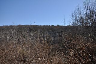
The Greystone Mill Historic District encompasses an early 20th-century textile mill complex on Greystone Avenue in Johnston and North Providence, Rhode Island. The complex consists of three brick buildings on the North Providence side of the Woonasquatucket River, a dam spanning the river, and a water tank near the dam in Johnston. The main structure consists of a series of structures combined to form a rambling structure, built between 1904 and 1911 to designs by Frank Sheldon and Son, an architectural firm that was a leading designer of textile facilities at the time.

The Old Ashton Historic District is a historic district encompassing an early 18th-century industrial area along Lower River Road in Lincoln, Rhode Island. It includes the site of the first textile mill in Lincoln, which was established in 1810–15, and whose original mill building no longer survives. The proprietors of the mill built a series of modest worker houses on Lower River Road, which are now separated from the mill site by a section of the Blackstone Canal. The only structure near the mill site is the Kelly House, built in the 1820s by Wilbur Kelly, one of the mill owners. The area is now a stopping point in Blackstone River Bikeway State Park, with interpretive signs explaining the area's history.

The Saylesville Friends Meetinghouse is an historic Quaker meetinghouse located at 374 Great Road within the village of Saylesville in the town of Lincoln, Rhode Island.

The South Central Falls Historic District is a historic district in Central Falls, Rhode Island. It is a predominantly residential area, densely populated, which was developed most heavily in the late 19th century. It is bounded roughly by Broad Street to the east, the Pawtucket city line to the south, Dexter Street to the west, and Rand Street and Jenks Park to the north. It has 377 contributing buildings, most of which were built before 1920. The district was added to the National Register of Historic Places in 1991.

The Wanskuck Historic District is a historic district in the city of Providence, Rhode Island encompassing a mill village with more than two hundred years of history. As early as the mid-18th century, mills stood on the West River in northern Providence, a development which continued with the rise of industrialization in the 19th century. The mill village of Wanskuck is organized around three thoroughfares: Branch Street, Veazie Street, and Woodward Road, and is roughly bounded on the east by Louisquisset Pike and to the northwest by the city line with North Providence. The West River runs through the district, with its banks lined by two late-19th-century mill complexes. The village area includes a variety of examples of mill worker housing, from duplexes to rowhouses, as well as two church complexes and a community hall built in 1884 by the Wanskuck Company.

The Davisville Historic District is a historic district on Davisville Road in Davisville, Rhode Island, a village in North Kingstown. It encompasses the site of an early 19th-century mill, and several associated buildings, including five houses dating to the 18th or 19th century and a cemetery. It is located on either side of Davisville Road, between the Hunt River and Olde Mill Lane.

The Shady Lea Historic District is a historic district on Shady Lea and Tower Hill Roads in North Kingstown, Rhode Island. It encompasses a predominantly residential linear district extending along Shady Lea Road southward from Tower Hill Road. Most of the houses along Shady Lea Road are mill worker housing built in the 19th century for workers at the mill complex which stands at the edge of the Shady Lea Mill Pond, at the southern end of the district. This area is a well-preserved example of the numerous rural mill complexes which dotted the Rhode Island countryside in the 19th century.

The Crompton Mill Historic District is a historic district encompassing a mill complex at 20 Remington Street, 53 and 65 Manchester Street in West Warwick, Rhode Island. The mill complex consists of a collection of mainly brick buildings, bounded by the Pawtuxet River and Pulaski, Remington, and Manchester Streets in the village of Crompton. The mill complex formerly extended across the river, but the complex on the west bank was destroyed by fire in 1992. The oldest elements of the complex are the dam site and some of the raceways that provided water power to the mills. The present dam was built in 1908, replacing an 1882 structure. The raceways were built in 1807, around the time of the first mill buildings. The stone Mill No. 1, built 1807, is believed to be the oldest stone mill building in the state. Most of the complex's buildings were built in the late 19th and early 20th centuries by the Providence Manufacturing Company and its successors. The mill was used for textile processing until 1946, when the Crompton Corporation ended production.

The South Main Street Historic District is a historic district in Coventry, Rhode Island. It extends along South Main Street from its crossing of the South Branch of the Pawtuxet River in the north, to just below Wood Street in the south, and includes a few properties on immediately adjacent streets. The area is almost entire residential, and was developed in the 19th century, providing housing for middle-class workers not directly affiliated with the mills that lined the river. About half the houses were built before 1850, and exhibit either Federal or Greek Revival styling, while most of the remaining houses were built before 1920. The principal non-residential structures are a VFW hall, which began as a mid-19th century residential structure associated with Rhode Island's prominent Whipple family, the Stillwater Company mill at the northern end of the district (1914), and the three-room Cady Street Schoolhouse (1844).

The East Blackstone Village Historic District is a historic district roughly along Elm Street at the junction with Summer Street in eastern Blackstone, Massachusetts. It encompasses a small 19th-century mill village center that developed along what was once a major roadway connecting Worcester with Providence, Rhode Island. The district was added to the National Register of Historic Places in 1995.

Hallville Mill Historic District is a historic district in the town of Preston, Connecticut, that was listed on the National Register of Historic Places in 1996. Contributing properties in the district are 23 buildings, two other contributing structures, and one other contributing site over a 50-acre (20 ha) area. The district includes the dam that forms Hallville Pond, historic manufacturing buildings and worker housing, and the Hallville Mill Bridge, a lenticular pony truss bridge built circa 1890 by the Berlin Iron Bridge Company.
Hallville Mill may refer to:
Blackstone River Valley National Historical Park is a National Park Service unit in the states of Rhode Island and Massachusetts. The park was created for the purpose of preserving, protecting, and interpreting the industrial heritage of the Blackstone River Valley and the urban, rural, and agricultural landscape of that region. The Blackstone River Valley was the site of some of the earliest successful textile mills in the United States, and these mills contributed significantly to the earliest American Industrial Revolution. The subsequent construction of the Blackstone Canal, a few years after the successful completion of the Erie Canal, helped to sustain the region's industrial strength.
