
North Kingstown is a town in Washington County, Rhode Island, United States, and is part of the Providence metropolitan area. The population was 27,732 in the 2020 census. North Kingstown is home to the birthplace of American portraitist Gilbert Stuart, who was born in the village of Saunderstown. Within the town is Quonset Point, location of the former Naval Air Station Quonset Point, known for the invention of the Quonset hut, as well as the historic village of Wickford.

Wakefield is a village in the town of South Kingstown, Rhode Island, United States, and the commercial center of South Kingstown. Together with the village of Peace Dale, it is treated by the U.S. Census as a component of the census-designated place identified as Wakefield-Peacedale. West Kingston, another South Kingstown village, was the traditional county seat of Washington County. Since 1991, the Washington County Courthouse has been in Wakefield. The Sheriff's Office which handles corrections is also in Wakefield.

Peace Dale is a village in the town of South Kingstown, Rhode Island, United States. Together with the village of Wakefield, it is treated by the U.S. Census as a component of the census-designated place identified as Wakefield-Peacedale.

Saunderstown is a small village and historic district in the towns of Narragansett and North Kingstown in Washington County, Rhode Island, United States. It was named in honor of John Aldrich Saunders, a member of the Saunders family. Saunderstown has its own post office with the ZIP Code of 02874, which also includes a small part of South Kingstown. Its population is 6,245.
The Hunt River is a river in the U.S. state of Rhode Island. It flows approximately 11 km (7 mi). There is a small stone dam just upstream from the Davisville Road bridge that powered a woolen mill active in the period 1811–1924.

Arnold Mills Historic District is a historic district encompassing a modest 19th-century mill village in eastern Cumberland, Rhode Island. The district lies along the Nate Whipple Highway and Sneech Pond Road, south of the Arnold Mills Reservoir. Sneech Pond Road was formerly the major east-west highway through the area prior to the construction of the Nate Whipple Highway in the 1960s. The Arnold Mills village is in part bisected by Abbott Run, the stream which serves as the outlet of the reservoir; Sneech Pond Road crosses the run on an early 20th-century steel Pratt pony truss, now closed to vehicular traffic. The houses along this road generally date from the late 18th to mid-19th century, and mainly reflect Federal and Greek Revival styling. The most prominent structure in the district is the Arnold Mills United Methodist Church, located at the western end of the district on Nate Whipple Highway; it was built 1825-27 and remodeled in 1846.

The Allen–Madison House is a historic house on Marine Road in North Kingstown, Rhode Island. It is located on the grounds of the former Davisville Naval Construction Battalion Center, set on an isolated plot apart from the main portion of the base.

The Wanskuck Historic District is a historic district in the city of Providence, Rhode Island encompassing a mill village with more than two hundred years of history. As early as the mid-18th century, mills stood on the West River in northern Providence, a development which continued with the rise of industrialization in the 19th century. The mill village of Wanskuck is organized around three thoroughfares: Branch Street, Veazie Street, and Woodward Road, and is roughly bounded on the east by Louisquisset Pike and to the northwest by the city line with North Providence. The West River runs through the district, with its banks lined by two late-19th-century mill complexes. The village area includes a variety of examples of mill worker housing, from duplexes to rowhouses, as well as two church complexes and a community hall built in 1884 by the Wanskuck Company.

Camp Endicott was a United States Navy Seabee facility, part of Davisville Naval Construction Battalion Center at Quonset Point in North Kingstown, Rhode Island. A surviving portion of the camp, now mostly demolished, was listed on the National Register of Historic Places in 1978.

The Crowfield Historic District is a small residential historic district in North Kingstown, Rhode Island. It encompasses a cluster of four early 20th-century summer houses, all connected via family or friendship connections to the writer Owen Wister. The occupy a large parcel of land sloping down to the shore of Narragansett Bay on the east side of Boston Neck Road, a short way north of the Jamestown Verrazzano Bridge. The area was named "Crowfield" by Elizabeth Middleton Cope, who built a Shingle-style mansion in 1906. Owen Wister, her uncle, built his house, Champ de Corbeau, in 1909-10 to a design by Grant Lafarge. The Jamieson House was also built in 1906, and was designed by the same architect, James P. Jamieson. The fourth house, Orchard House, was built in 1924. All are Shingle style houses. The compound is unusual for North Kingstown, where most summer estates were isolated individual properties.

The George Douglas House is an historic house at Tower Hill and Gilbert Stuart Roads in North Kingstown, Rhode Island. Its oldest section dated to the 1730s, it is one of a small number of surviving colonial-era stone ender houses in the state. This original block is three bays wide and two stories high, with a massive fieldstone chimney at its north end. Its exterior ornamentation is minimal, limited to pilasters on either side of the main entrance, and a triangular pediment above. A small kitchen ell was added to the north side, probably early in the 19th century, and a bedroom further extended this ell in the 1940s.

The Ezekial Gardner House was an historic house at 297 Pendar Road in North Kingstown, Rhode Island. It was a 1+1⁄2-story wood-frame house, with a gambrel roof. The oldest portion of the house dated to the early 18th century, and was the best-preserved of several period houses built by members of the locally prominent Gardner family. The house stood, along with an early 20th-century barn, at the end of a long tree-lined lane on the west side of Pendar Road.

The Hamilton Mill Village Historic District is a historic district encompassing a small mill village in North Kingstown, Rhode Island. It is located on the south side of the Annaquatucket River, near its mouth at Bissell Cove. The village includes two wood-frame mill buildings and a collection of mill worker housing units, which line a short section of Boston Neck Road as well as Salisbury Avenue, Web Avenue, and Martha Road. The most impressive mill building is the main mill, built in 1853 and enlarged in 1866 with a double clerestory roof, something not found in other surviving mills in the state.
Lafayette Village is a historic district extending along Ten Rod Road in North Kingstown, Rhode Island. It encompasses a linear rural and industrial village, running from the Wickford Junction railroad crossing in the west to Angel Avenue in the east, and includes a number of residential properties on adjacent side streets. The centerpiece of the district is the Rodman Manufacturing Company complex, which operated here for a century beginning in the 1840s. The Robert Rodman Mansion, a Second Empire house with an elaborate porch, stands at 731 Ten Rod Road, and the Walter Rodman House, built in the 1870s, is even more elaborately decorated. Most of the residential stock in the district is mill-related housing built by the Rodmans for their workers.
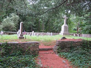
The Old Narragansett Cemetery is an historic cemetery on Shermantown Road in North Kingstown, Rhode Island. Variant names for the cemetery include Narragansett Cemetery, Platform Cemetery, and The Platform Cemetery. The cemetery occupies a 1.2 acres (0.49 ha) plot about 300 feet (91 m) south of Shermantown Road, roughly midway between its two junctions with Mourning Dove Drive. It was established early in the 18th century, and is one of North Kingstown's oldest and longest-used cemeteries. It has 110 marked graves, and was used from its establishment c. 1705 to the 1880s. The most prominent memorials are to James MacSparran and Samuel Fayerweather, two long-serving ministers at the Old Narragansett Church, which stood nearby when it was built in 1706.

The Joseph Pierce Farm is an historic farm at 933 Gilbert Stuart Road in North Kingstown, Rhode Island. It consists of 18 acres (7.3 ha) of land, along with an 18th-century farmhouse and a number of 19th-century outbuildings. The oldest portion of the house, its southern ell, was originally built with a gable roof, but this was extended to the north in the late 18th or early 19th century, and given it present gambrel roof and Federal styling. Later additions in the 19th and 20th centuries gave the house its present cruciform appearance. Outbuildings dating to the 19th century include a barn with attached privy, a toolshed, and a henhouse. The complex is a well-preserved reminder of the area's rural heritage.

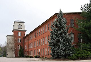
The Shady Lea Historic District is a historic district on Shady Lea and Tower Hill Roads in North Kingstown, Rhode Island. It encompasses a predominantly residential linear district extending along Shady Lea Road southward from Tower Hill Road. Most of the houses along Shady Lea Road are mill worker housing built in the 19th century for workers at the mill complex which stands at the edge of the Shady Lea Mill Pond, at the southern end of the district. This area is a well-preserved example of the numerous rural mill complexes which dotted the Rhode Island countryside in the 19th century.

Six Principle Baptist Church is a historic church in North Kingstown, Rhode Island. As of 2009 it was one of the last surviving historical congregations of the Six Principle Baptist denomination and one of the oldest churches in the United States.

The Joseph Slocum House is an historic house on Slocum Road in North Kingstown, Rhode Island. It is a 1+1⁄2-story wood-frame house, five bays wide, with a large central chimney. It faces south on the east side of Slocum Road. The house has been dated to the mid-18th century based on architectural evidence; its first documented owner was Joseph Slocum, in the early 19th century. The house is a rare surviving 18th-century farmhouse, a type once numerous in the town.

The Spink Farm is a historic farm at 1325 Shermantown Road in North Kingstown, Rhode Island. The only surviving element of the farmstead on this 55-acre (22 ha) farm is the main house, a 2+1⁄2-story five-bay wood-frame structure built in 1798 by Isaac Spink. The house exhibits modest Federal styling, its doorway flanked by small sidelight windows and simple pilasters, and topped by a shallow hood. The interior follows a typical center-chimney plan, with its original Federal period fireplace mantels intact. The house has been extended to the rear by a kitchen ell and porch, both added in the 20th century. The house is one of a small number of 18th-century farmsteads left in the town.


