
West Warwick is a town in Kent County, Rhode Island, United States. The population was 31,012 at the 2020 census.

Wakefield is a village in the town of South Kingstown, Rhode Island, United States, and the commercial center of South Kingstown. Together with the village of Peace Dale, it is treated by the U.S. Census as a component of the census-designated place identified as Wakefield-Peacedale, Rhode Island. West Kingston, another South Kingstown village, was the traditional county seat of Washington County. Since 1991, the Washington County Courthouse has been in Wakefield. The Sheriff's Office which handles corrections is also in Wakefield.

Peace Dale is a village in the town of South Kingstown, Rhode Island. Together with the village of Wakefield, it is treated by the U.S. Census as a component of the census-designated place identified as Wakefield-Peacedale, Rhode Island.
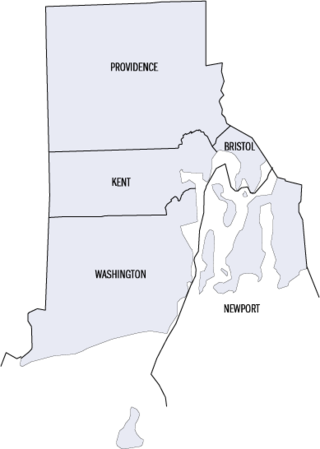
This is a list of properties and districts listed on the National Register of Historic Places in Rhode Island. As of May 29, 2015, there are more than 750 listed sites in Rhode Island. All 5 of the counties in Rhode Island have listings on the National Register.

Slatersville is a village on the Branch River in the town of North Smithfield, Rhode Island, United States. It includes the Slatersville Historic District, a historic district listed on the National Register of Historic Places. The historic district has been included as part of the Blackstone River Valley National Historical Park. The North Smithfield Public Library is located in Slatersville.
Forestdale is a village and historic district in North Smithfield, Providence County, Rhode Island, United States, one-half mile from Slatersville, Rhode Island. The historic district runs east and west along Main Street and north on Maple Avenue. School Street is the primary road through the village, and the one-room schoolhouse for which the street is named still stands. The Branch River runs through the valley adjacent to the School Street. The Village Haven Restaurant and local VFW chapter are also located in the village.
Carolina is a village that straddles the border of the towns of Charlestown and Richmond on the Pawcatuck River in Washington County, Rhode Island. Rhode Island Route 112 passes through the village. Carolina is identified as a census-designated place, with a population of 970 at the 2010 census.

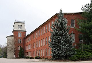
Saylesville is a village and historic district in Lincoln, Rhode Island.

The Central Falls Mill Historic District is located between Roosevelt Avenue and the Blackstone River in Central Falls, Rhode Island. It encompasses a collection of six mill buildings, as well as a stone dam which impounds the river, representing the finest mill constructions in the city during the 19th century. The layout of the buildings, whose short ends face the river and Roosevelt Avenue, was defined by a series of trenches which channeled water from the river to power the machinery of the mills. The oldest building dates to 1825, and the most recent to c. 1910; all have been modified to some extent by later industrial tenants.

The Ashton Historic District is a historic district in Cumberland, Rhode Island. The district consists of a mill and an adjacent mill village that was built for the workers of the mill. It lies between Mendon Road, Scott Road, Angell Road, Store Hill Road, Front Street and Middle Street. The district was added to the National Register of Historic Places on November 1, 1984.
Clayville Historic District is an 81-acre (33 ha) historic district in Foster and Scituate, Rhode Island. The district encompasses the heart of the village of Clayville, a small 19th-century mill village. It is centered on the junction of Plainfield Pike, Field Hill Road, and Victory Highway near the Clayville Mill pond, and is roughly bisected by the town line between Foster and Scituate. The mill pond is impounded by a c. 1847 dam, which powered mills whose ruins and waterways lie downstream. The village is mainly residential, with vernacular 19th-century construction predominating. Notable buildings include the Clayville Christian Union Church, built 1867–71 with Greek Revival styling, and the c. 1845 Clayville Schoolhouse.

The Davisville Historic District is a historic district on Davisville Road in Davisville, Rhode Island, a village in North Kingstown. It encompasses the site of an early 19th-century mill, and several associated buildings, including five houses dating to the 18th or 19th century and a cemetery. It is located on either side of Davisville Road, between the Hunt River and Olde Mill Lane.

The Hope Village Historic District is a historic rural mill settlement within Hope Village in Scituate, Rhode Island. Hope Village is located on a bend in the North Pawtuxet River in the southeastern corner of Scituate. Industrial activity has occurred in Hope Village since the mid-eighteenth century. Surviving industrial and residential buildings in the Historic District date back to the early 19th century. The village center sits at junction of Main Street and North Road. Hope Village radiates out from the center with houses on several smaller side streets in a compact configuration. Currently there is little commercial or industrial activity in Hope Village and none in the Historic District. The present stone mill building on the south side of Hope Village was built in 1844 by Brown & Ives of Providence, expanded in 1871 and modified in 1910. Approximately one quarter of the village's current housing stock was built as mill worker housing by various owners of Hope Mill.
Lafayette Village is a historic district extending along Ten Rod Road in North Kingstown, Rhode Island. It encompasses a linear rural and industrial village, running from the Wickford Junction railroad crossing in the west to Angel Avenue in the east, and includes a number of residential properties on adjacent side streets. The centerpiece of the district is the Rodman Manufacturing Company complex, which operated here for a century beginning in the 1840s. The Robert Rodman Mansion, a Second Empire house with an elaborate porch, stands at 731 Ten Rod Road, and the Walter Rodman House, built in the 1870s, is even more elaborately decorated. Most of the residential stock in the district is mill-related housing built by the Rodmans for their workers.

The Shannock Historic District is a historic mill village located along the Pawcatuck River in the towns of Richmond and Charlestown, Rhode Island. The postal code for Shannock is 02875. The village extends along Old Shannock Road, Railroad Street, and Shannock Village Road between two crossings of the Pawcatuck, which forms the border between the two towns. It lies mainly in Richmond, but extends along the road running southwest and southeast from the two crossings. Two mill complexes are the visual focal points of the village: the Carmichael plant on the west, and the Columbia Narrow Fabrics Company complex near the village center. The buildings in the village are predominantly residential worker housing set close to the road, which were built in the second half of the 19th century. There are two imposing Greek Revival houses, both built c. 1850, and one Late Victorian house, all of which belonged to mill owners. The area was listed on the National Register of Historic Places in 1983.

Wyoming is a village and census-designated place on the Wood River in southern Rhode Island, primarily in the town of Richmond, Rhode Island, but extending north across the river into the town of Hopkinton, Rhode Island. The population was 270 at the 2010 census. It is the site of the Wyoming Village Historic District and a post office assigned ZIP code 02898.

The French Worsted Company Mill Historic District encompassed a historic mill complex in Woonsocket, Rhode Island. Bounded by Hamlet Avenue, Davison Avenue, and Manville Road, a complex of sixteen brick buildings was built between 1906 and the late 1920s. The complex was home to the French Worsted Company, a manufacturer established with funds from French investors brought over by Aram Pothier, the Quebec-born mayor of Woonsocket. The company engaged in the manufacture of fine worsted wool yarns. The company survived the Great Depression and competition from Southern mills, but finally failed in 1969. The buildings were then converted to a variety of light manufacturing interests.

The Greystone Historic District is a historic district encompassing the early 20th-century mill village of Greystone in North Providence, Rhode Island. The district most significant elements is the Greystone Mill, a complex of brick industrial buildings on the North Providence side of the Woonasquatucket River, as well as the dam spanning the river and a water tank in Johnston. The village, entirely in North Providence, was developed between 1904 and 1912 by Joseph Benn and Company, the mill proprietors, to provide housing for its workers. The main focus of the village is on junction of Greystone Road and Oakleigh Avenue. The company built a variety of housing types, including duplexes and tenements, which line some of the side streets. There are four houses, dating as far back as 1822, that predate the primary industrial activity here. The most prominent feature of the village is the Greystone (Primitive) Methodist Church on Oakleigh Avenue.

Anthony is a village along Route 117 within the town of Coventry, Rhode Island near the villages of Washington and Quidnick on the southwestern banks of the Pawtuxet River. The village comprises "Anthony, Arnold, Boston, Mapledale, Meeting, Taft, Washington and Laurel Avenue."

The Phillipsdale Historic District encompasses a historic mill village along the Seekonk River in East Providence, Rhode Island. The village grew up around the Richmond Paper Company Mill Complex, built 1883-1887, which is separately listed on the National Register. It also includes 75 units of worker housing, as well as five houses that predate the mill complex's construction. The Phillipsdale area was the largest source of employment in East Providence between 1893 and 1910. The district is centered on Roger Williams Avenue and Bourne Avenue, and includes properties on Ruth Avenue and the grid of roads between Ruth and Roger Williams. It also includes Omega Pond and the Omega Pond Railroad Bridge.


