
Wakefield is a village in the town of South Kingstown, Rhode Island, United States, and the commercial center of South Kingstown. Together with the village of Peace Dale, it is treated by the U.S. Census as a component of the census-designated place identified as Wakefield-Peacedale, Rhode Island. West Kingston, another South Kingstown village, was the traditional county seat of Washington County. Since 1991, the Washington County Courthouse has been in Wakefield. The Sheriff's Office which handles corrections is also in Wakefield.

Peace Dale is a village in the town of South Kingstown, Rhode Island. Together with the village of Wakefield, it is treated by the U.S. Census as a component of the census-designated place identified as Wakefield-Peacedale, Rhode Island.

Slatersville is a village on the Branch River in the town of North Smithfield, Rhode Island, United States. It includes the Slatersville Historic District, a historic district listed on the National Register of Historic Places. The historic district has been included as part of the Blackstone River Valley National Historical Park. The North Smithfield Public Library is located in Slatersville.

Union Village or "Bank Village" is a village and historic district located in North Smithfield and Woonsocket, Rhode Island on Rhode Island Route 146A. Union Village developed because it was at the cross roads of old Great Road and Pound Hill Road.
Carolina is a village that straddles the border of the towns of Charlestown and Richmond on the Pawcatuck River in Washington County, Rhode Island. Rhode Island Route 112 passes through the village. Carolina is identified as a census-designated place, with a population of 970 at the 2010 census.
Oakland is a village in Burrillville, Providence County, Rhode Island, United States. It was developed in the 19th century at the site of a stone mill near the confluence of the Chepachet and Clear Rivers. It is one of the few remaining stone mills in this state. Most of the village is included in the Oakland Historic District, a historic district listed on the National Register of Historic Places. Most of the housing in the village was originally built to house mill workers, although there are several more elaborate houses built for mill executives.

Saylesville is a village and historic district in Lincoln, Rhode Island.

Arnold Mills Historic District is a historic district encompassing a modest 19th-century mill village in eastern Cumberland, Rhode Island. The district lies along the Nate Whipple Highway and Sneech Pond Road, south of the Arnold Mills Reservoir. Sneech Pond Road was formerly the major east-west highway through the area prior to the construction of the Nate Whipple Highway in the 1960s. The Arnold Mills village is in part bisected by Abbott Run, the stream which serves as the outlet of the reservoir; Sneech Pond Road crosses the run on an early 20th-century steel Pratt pony truss, now closed to vehicular traffic. The houses along this road generally date from the late 18th to mid-19th century, and mainly reflect Federal and Greek Revival styling. The most prominent structure in the district is the Arnold Mills United Methodist Church, located at the western end of the district on Nate Whipple Highway; it was built 1825-27 and remodeled in 1846.

The Ashton Historic District is a historic district in Cumberland, Rhode Island. The district consists of a mill and an adjacent mill village that was built for the workers of the mill. It lies between Mendon Road, Scott Road, Angell Road, Store Hill Road, Front Street and Middle Street. The district was added to the National Register of Historic Places on November 1, 1984.
Berkeley Mill Village is a historic district encompassing the mill village of Berkeley in Cumberland, Rhode Island. The village is roughly bounded by Martin Street and Mendon Road on the north and east, railroad tracks to the west, and St. Joseph Cemetery to the south. The village, including a mill complex and mill employee housing, was built in 1872 by the Lonsdale Company. Most of the residential structures built are two-story brick duplexes, although Mendon Street is lined with a number of fine Queen Anne Victorian houses. A c. 1892 Stick-style church building, stands on Mendon Street at the northern end of the district.
Clayville Historic District is an 81-acre (33 ha) historic district in Foster and Scituate, Rhode Island. The district encompasses the heart of the village of Clayville, a small 19th-century mill village. It is centered on the junction of Plainfield Pike, Field Hill Road, and Victory Highway near the Clayville Mill pond, and is roughly bisected by the town line between Foster and Scituate. The mill pond is impounded by a c. 1847 dam, which powered mills whose ruins and waterways lie downstream. The village is mainly residential, with vernacular 19th-century construction predominating. Notable buildings include the Clayville Christian Union Church, built 1867–71 with Greek Revival styling, and the c. 1845 Clayville Schoolhouse.

The Hope Village Historic District is a historic rural mill settlement within Hope Village in Scituate, Rhode Island. Hope Village is located on a bend in the North Pawtuxet River in the southeastern corner of Scituate. Industrial activity has occurred in Hope Village since the mid-eighteenth century. Surviving industrial and residential buildings in the Historic District date back to the early 19th century. The village center sits at junction of Main Street and North Road. Hope Village radiates out from the center with houses on several smaller side streets in a compact configuration. Currently there is little commercial or industrial activity in Hope Village and none in the Historic District. The present stone mill building on the south side of Hope Village was built in 1844 by Brown & Ives of Providence, expanded in 1871 and modified in 1910. Approximately one quarter of the village's current housing stock was built as mill worker housing by various owners of Hope Mill.

Lawton's Mill is a historic mill located on Ten Rod Road in Exeter, Rhode Island. The mill property includes an 18th-century house, an early 19th-century wood-frame mill building, and a 19th-century barn with early 20th-century additions. Also surviving from the period of the mill's activity are dams and waterways associated with it, including a dam and raceway extending several hundred feet north of the mill building. The mill building, which was built c. 1820, is one of a very small number of mill buildings to survive from the period in Rhode Island.

The Shady Lea Historic District is a historic district on Shady Lea and Tower Hill Roads in North Kingstown, Rhode Island. It encompasses a predominantly residential linear district extending along Shady Lea Road southward from Tower Hill Road. Most of the houses along Shady Lea Road are mill worker housing built in the 19th century for workers at the mill complex which stands at the edge of the Shady Lea Mill Pond, at the southern end of the district. This area is a well-preserved example of the numerous rural mill complexes which dotted the Rhode Island countryside in the 19th century.

The Shannock Historic District is a historic mill village located along the Pawcatuck River in the towns of Richmond and Charlestown, Rhode Island. The postal code for Shannock is 02875. The village extends along Old Shannock Road, Railroad Street, and Shannock Village Road between two crossings of the Pawcatuck, which forms the border between the two towns. It lies mainly in Richmond, but extends along the road running southwest and southeast from the two crossings. Two mill complexes are the visual focal points of the village: the Carmichael plant on the west, and the Columbia Narrow Fabrics Company complex near the village center. The buildings in the village are predominantly residential worker housing set close to the road, which were built in the second half of the 19th century. There are two imposing Greek Revival houses, both built c. 1850, and one Late Victorian house, all of which belonged to mill owners. The area was listed on the National Register of Historic Places in 1983.

Wyoming is a village and census-designated place on the Wood River in southern Rhode Island, primarily in the town of Richmond, Rhode Island, but extending north across the river into the town of Hopkinton, Rhode Island. The population was 270 at the 2010 census. It is the site of the Wyoming Village Historic District and a post office assigned ZIP code 02898.

The Attleborough Falls Historic District is a predominantly residential historic district on Mt. Hope and Towne Streets in North Attleborough, Massachusetts. Located just south of the Ten Mile River, it encompasses a stylish mid-to-late 19th century residential area that developed in a previously rural area due to industrial development across the river. The district was added to the National Register of Historic Places in 2004.

The Benoni Rose House is an historic house at 97 Lafayette Road in North Kingstown, Rhode Island. It is a 1+1⁄2-story wood-frame structure, built in 1882 for Benoni Rose, a finisher at the mill in nearby Lafayette Village. The house is an excellent and well-preserved example of simple vernacular Victorian architecture. Unlike more elaborate example of the style, the styling of this house is limited to its porch, entrance and stairway. The Roses were among the first to buy land in this area, outside the main village and across the Annaquatucket River.

The Manville Company Worker Housing Historic District is a residential historic district encompassing an area of mill worker housing in the Manville village of Lincoln, Rhode Island. The district covers about 50 acres (20 ha) of the village, including properties on Angle, Main, Old Main, Spring, Summer, Winter, and Chestnut Streets, as well as several properties on adjoining roads, describing a crescent, part of which abuts the south bank of the Blackstone River. The housing in this district was built between about 1812 and 1890 by the various proprietors of the Manville Company, and feature a diversity of architectural styles, most of which are simple vernacular interpretations of styles popular at the time. Most of the houses are either 1-1/2 or 2-1/2 stories in height, with one or two units per structure, and are set on small lots. There are also a series of brick rowhouses, a relative rarity in Rhode Island mill housing of the period.
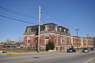
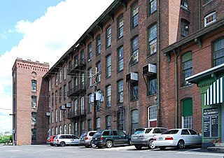
The Lafayette Worsted Company Administrative Headquarters Historic District encompasses the two surviving buildings of a once-extensive textile mill complex in Woonsocket, Rhode Island. Located near the Woonsocket Middle School on Hamlet Avenue are a former guest house, built about 1920, and the mill's 1923 administration building, an elaborate Second Empire brick building designed by Woonsocket architect Walter F. Fontaine. The Lafayette Worsted Mill, established in 1900, was one of three major local mills engaged in the French style of worsted wool production. Most of its buildings were demolished in 2008.


