
Cumberland is the northeasternmost town in Providence County, Rhode Island, United States, first settled in 1635 and incorporated in 1746. The population was 36,405 at the 2020 census, making it the seventh-largest municipality and the largest town in the state.
Lincoln is a town in Providence County, Rhode Island, United States. The population was 22,529 at the 2020 census. Lincoln is located in northeastern Rhode Island, north of Providence. Lincoln is part of the Providence metropolitan statistical area and the Greater Boston combined statistical area.

The Blackstone Canal was a waterway linking Worcester, Massachusetts, to Providence, Rhode Island through the Blackstone Valley via a series of locks and canals during the early 19th century. Construction was started in 1825, and the canal opened three years later. Following the opening of the Boston and Providence Railroad in 1835, the canal struggled for business. It was ultimately replaced by the Providence and Worcester Railroad, which completed a parallel line using much of the canal right-of-way in 1847, the canal shut down in 1848. Several segments of the canal are preserved.

The Slater Mill is a historic water-powered textile mill complex on the banks of the Blackstone River in Pawtucket, Rhode Island, modeled after cotton spinning mills first established in England. It is the first water-powered cotton spinning mill in America to utilize the Arkwright system of cotton spinning as developed by Richard Arkwright.

The Eleazer Arnold House is a historic house built for Eleazer Arnold in about 1693, and located in the Great Road Historic District at Lincoln, Rhode Island. It is now a National Historic Landmark owned by Historic New England, and open to the public on weekends.

The Clemence–Irons House is a historic house located in Johnston, Rhode Island. It was built by Richard Clemence in 1691 and is a rare surviving example of a "stone ender", a building type first developed in the western part of England and common in colonial Rhode Island. The house is listed on the National Register of Historic Places, and is a historic house museum owned and operated by Historic New England. It is open Saturdays between June and mid-October.

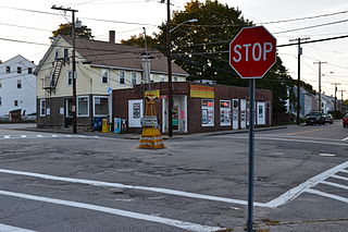
Union Village or "Bank Village" is a village and historic district located in North Smithfield and Woonsocket, Rhode Island on Rhode Island Route 146A. Union Village developed because it was at the cross roads of old Great Road and Pound Hill Road.

Lime Rock (Limerock) is a village and historic district in Lincoln, Providence County, Rhode Island, United States, near Rhode Island Route 146. The village was named after the limestone quarries in the area, which started in the 17th century, and continue to the present where Conklin Limestone Company now operates. Because of the abundance of limestone in the area many houses had massive end chimneys and were called "stone enders," a distinctly Rhode Island style of architecture. The historic district includes 21 historically significant properties in an area extending from Wilbur Road, just west of its junction with Old Louisquisset Pike, eastward to Great Road, and then along Great Road as far as Simon Sayles Road. Among these properties are three quarries, and the ruins of three old lime kilns. It was listed on the National Register of Historic Places in 1974.

This is a list of the National Register of Historic Places listings in Providence County, Rhode Island.
Carolina is a village that straddles the border of the towns of Charlestown and Richmond on the Pawcatuck River in Washington County, Rhode Island. Rhode Island Route 112 passes through the village. Carolina is identified as a census-designated place, with a population of 970 at the 2010 census.
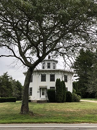
Albion is a village and historic district in Lincoln, Rhode Island, in the United States.

Saylesville is a village and historic district in Lincoln, Rhode Island.

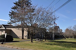
The College Hill Historic District is located in the College Hill neighborhood of Providence, Rhode Island. It was designated a National Historic Landmark District on December 30, 1970. The College Hill local historic district, established in 1960, partially overlaps the national landmark district. Properties within the local historic district are regulated by the city's historic district zoning ordinance, and cannot be altered without approval from the Providence Historic District Commission.
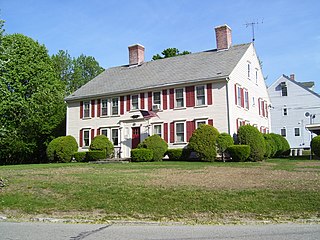
The Peleg Arnold Tavern off Great Road in Union Village in North Smithfield, Rhode Island was built around 1690 and is one of the oldest homes in North Smithfield. The oldest part of house was built in the late 17th century by Richard Arnold, one of the earliest settlers in the area. His descendant, Peleg Arnold, greatly expanded the building a century later. Peleg Arnold was a justice of the Rhode Island Supreme Court and representative to the Continental Congress. Arnold's popular tavern served as center of American military operations in the town during the American Revolution. The house was added to the National Register of Historic Places in 1974.

The Alfred Drowne Road Historic District of Barrington, Rhode Island, encompasses a suburban area developed between about 1860 and 1910, a period of significant suburban growth in Barrington spurred by the connection of the town by rail to Providence in 1855. This 27-acre (11 ha) residential area was before that time farmland owned by Alfred Drown, whose c. 1830 farmhouse still stands at 13 Alfred Drowne Road. The house of his son Benjamin, built c. 1856, is at number 27. The district includes properties along Alfred Drowne Road, as well as a few properties on Washington Street and Annawamscutt Road which are immediately adjacent.

Arnold Mills Historic District is a historic district encompassing a modest 19th-century mill village in eastern Cumberland, Rhode Island. The district lies along the Nate Whipple Highway and Sneech Pond Road, south of the Arnold Mills Reservoir. Sneech Pond Road was formerly the major east-west highway through the area prior to the construction of the Nate Whipple Highway in the 1960s. The Arnold Mills village is in part bisected by Abbott Run, the stream which serves as the outlet of the reservoir; Sneech Pond Road crosses the run on an early 20th-century steel Pratt pony truss, now closed to vehicular traffic. The houses along this road generally date from the late 18th to mid-19th century, and mainly reflect Federal and Greek Revival styling. The most prominent structure in the district is the Arnold Mills United Methodist Church, located at the western end of the district on Nate Whipple Highway; it was built 1825-27 and remodeled in 1846.

The Furnace Carolina Site is an historic site of a blast furnace in Cumberland, Rhode Island along the Abbott Run river.

The Old Ashton Historic District is a historic district encompassing an early 18th-century industrial area along Lower River Road in Lincoln, Rhode Island. It includes the site of the first textile mill in Lincoln, which was established in 1810–15, and whose original mill building no longer survives. The proprietors of the mill built a series of modest worker houses on Lower River Road, which are now separated from the mill site by a section of the Blackstone Canal. The only structure near the mill site is the Kelly House, built in the 1820s by Wilbur Kelly, one of the mill owners. The area is now a stopping point in Blackstone River Bikeway State Park, with interpretive signs explaining the area's history.

The Woonsocket Company Mill Complex is a historic district encompassing one of the largest mill complexes in Woonsocket, Rhode Island. The district includes all of the buildings historically associated with the Woonsocket Company, a major manufacturer of cotton textiles in the 19th century. The complex is located along the eastern bank of the Blackstone River between Court and Bernon Streets. It includes three handsome stone mills, built between 1827 and 1859, and a power plant that was built on the site of the former #3 mill between 1890 and 1920, as well as the remnants of the canal that originally carried water to the buildings for power.

The Phillipsdale Historic District encompasses a historic mill village along the Seekonk River in East Providence, Rhode Island. The village grew up around the Richmond Paper Company Mill Complex, built 1883-1887, which is separately listed on the National Register. It also includes 75 units of worker housing, as well as five houses that predate the mill complex's construction. The Phillipsdale area was the largest source of employment in East Providence between 1893 and 1910. The district is centered on Roger Williams Avenue and Bourne Avenue, and includes properties on Ruth Avenue and the grid of roads between Ruth and Roger Williams. It also includes Omega Pond and the Omega Pond Railroad Bridge.


