
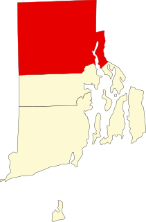
North Smithfield is a town in Providence County, Rhode Island, United States, settled as a farming community in 1666 and incorporated into its present form in 1871. North Smithfield includes the historic villages of Forestdale, Primrose, Waterford, Branch Village, Union Village, Park Square, and Slatersville. The population was 12,314 at the 2015 census.

Wakefield is a village in the town of South Kingstown, Rhode Island, United States, and the commercial center of South Kingstown. Together with the village of Peace Dale, it is treated by the U.S. Census as a component of the census-designated place identified as Wakefield-Peacedale, Rhode Island. West Kingston, another South Kingstown village, was the traditional county seat of Washington County. Since 1991, the Washington County Courthouse has been in Wakefield. The Sheriff's Office which handles corrections is also in Wakefield.

The Eleazer Arnold House is a historic house built for Eleazer Arnold in about 1693, and located in the Great Road Historic District at Lincoln, Rhode Island. It is now a National Historic Landmark owned by Historic New England, and open to the public on weekends.

Slatersville is a village on the Branch River in the town of North Smithfield, Rhode Island, United States. It includes the Slatersville Historic District, a historic district listed on the National Register of Historic Places. The historic district has been included as part of the Blackstone River Valley National Historical Park. The North Smithfield Public Library is located in Slatersville.
Forestdale is a village and historic district in North Smithfield, Providence County, Rhode Island, United States, one-half mile from Slatersville, Rhode Island. The historic district runs east and west along Main Street and north on Maple Avenue. School Street is the primary road through the village, and the one-room schoolhouse for which the street is named still stands. The Branch River runs through the valley adjacent to the School Street. The Village Haven Restaurant and local VFW chapter are also located in the village.

Union Village or "Bank Village" is a village and historic district located in North Smithfield and Woonsocket, Rhode Island on Rhode Island Route 146A. Union Village developed because it was at the cross roads of old Great Road and Pound Hill Road.

Lime Rock (Limerock) is a village and historic district in Lincoln, Providence County, Rhode Island, United States, near Rhode Island Route 146. The village was named after the limestone quarries in the area, which started in the 17th century, and continue to the present where Conklin Limestone Company now operates. Because of the abundance of limestone in the area many houses had massive end chimneys and were called "stone enders," a distinctly Rhode Island style of architecture. The historic district includes 21 historically significant properties in an area extending from Wilbur Road, just west of its junction with Old Louisquisset Pike, eastward to Great Road, and then along Great Road as far as Simon Sayles Road. Among these properties are three quarries, and the ruins of three old lime kilns. It was listed on the National Register of Historic Places in 1974.

Ironstone is an historic village,, in the township of Uxbridge, Massachusetts, United States. It derived its name from plentiful bog iron found here which helped Uxbridge to become a center for three iron forges in the town's earliest settlement. South Uxbridge has historic sites, picturesque weddings, hospitality, industrial and distribution centers, and the new Uxbridge High School. This community borders North Smithfield, and Burrillville, Rhode Island, and Millville, Massachusetts. South Uxbridge receives municipal services from Uxbridge, for fire, police, EMS, School district, public works, and other services. There is a South Uxbridge fire station of the Uxbridge fire department. Worcester's Judicial District includes Uxbridge District Court. Ironstone appears on the Blackstone U.S. Geological Survey Map. Worcester County is in the Eastern time zone and observes DST.
This is a list of the National Register of Historic Places listings in Providence County, Rhode Island.

Carolina is a village that straddles the border of the towns of Charlestown and Richmond on the Pawcatuck River in Washington County, Rhode Island. Rhode Island Route 112 passes through the village. Carolina is identified as a census-designated place, with a population of 970 at the 2010 census.
The Newport Historic District is a historic district that covers 250 acres in the center of Newport in the U.S. state of Rhode Island. It was designated a National Historic Landmark (NHL) in 1968 due to its extensive and well-preserved assortment of intact colonial buildings dating from the early and mid-18th century. Six of those buildings are themselves NHLs in their own right, including the city's oldest house and the former meeting place of the colonial and state legislatures. Newer and modern buildings coexist with the historic structures.
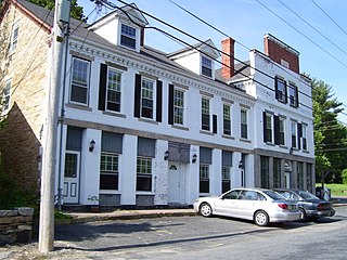
The Peleg Arnold Tavern off Great Road in Union Village in North Smithfield, Rhode Island was built around 1690 and is one of the oldest homes in North Smithfield. The oldest part of house was built in the late 17th century by Richard Arnold, one of the earliest settlers in the area. His descendant, Peleg Arnold, greatly expanded the building a century later. Peleg Arnold was a justice of the Rhode Island Supreme Court and representative to the Continental Congress. Arnold's popular tavern served as center of American military operations in the town during the American Revolution. The house was added to the National Register of Historic Places in 1974.

The Smithfield Friends Meeting House, Parsonage and Cemetery, is a Friends Meeting House of the Religious Society of Friends (Quakers), rebuilt in 1881. It is located at 108 Smithfield Road in Woonsocket, Rhode Island. The meetinghouse is home to one of the oldest Quaker communities in the region.

Allenville Mill Storehouse is a historic mill storehouse at 5 Esmond Street in Esmond, Rhode Island within the town of Smithfield, Rhode Island. The exact date of construction is unknown, but it was built with rubble masonry construction which was typical of mill construction during and after the War of 1812. In 1813, Phillip Allen purchased 4.5 acres of land and constructed a mill on the site, but the first record to specifically refer to the storehouse was an insurance policy from 1836. Allen sold the property in 1857 and it changed ownership several times before it became Esmond Mills in 1906. In 1937, the building was used as a post office and described erroneously as the "Old Allenville Mill". The building has had some alterations to the front door and possibly the addition of a side door, but the interior of the structure was not detailed in the National Register of Historic Places nomination. The Allenville Mill Storehouse was added to the National Register of Historic Places in 1972.

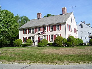
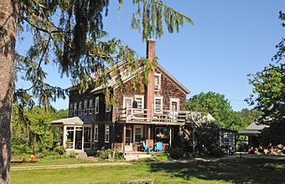
The Todd Farm is an historic farm at 670 Farnum Pike in North Smithfield, Rhode Island, US. The farm includes a house dating to 1740, as well as a collection of outbuildings dating to the early 20th century. The main block of the house is a 2 1⁄2-story wood-frame structure, five bays wide, with a gable roof and a large central chimney. The main block has been added to numerous times, with full-size additions to both sides as well as a sloping addition to the rear, giving the house a saltbox appearance in the rear and a total width of 11 bays. Behind and beside the house are arrayed a number of small outbuildings, and a barn which has been converted into residential space. The house was probably built by Noah Smith around 1740, around the time he established a sawmill on Cherry Brook, which runs behind the house and is dammed to form Todd Pond.
The Austin Farm Road Agricultural Area is a rural historic district in Exeter, Rhode Island. The district is bounded on the east by Interstate 95, on the north by the town line, on the south by Austin Farm Road, and on the west by a north-south line through Austin Farm Pond. This agricultural area is relatively little altered since the late 19th century, despite the proximity of the interstate. It includes the farm complex built up by John Austin in the 19th century, which continues to see active use, and the site of an older farm complex, reduced to just the farmhouse, which predates Austin's acquisition of the property. In addition to the farm buildings, it includes a chapel and school house built or maintained by Austin.

East Greenwich Historic District is a historic district encompassing the historic commercial and civic heart of East Greenwich, Rhode Island, United States. The district bounded on the east by Greenwich Cove, an inlet on Narrangansett Bay, on the south by London and Spring Streets, on the west roughly by Park Street, and on the north by Division Street. The district extends westward on Division Street as far Dark Entry Brook, and the district properties on its north side now lie in the city of Warwick. East Greenwich was settled in 1677 with its town center growing in the district, with a rural farm landscape to the west. The area's road network had begun to take shape by the mid-18th century, and the town center was industrialized in the 19th century.
Marion is a neighborhood in the town of Southington in Hartford County, Connecticut, United States. It is generally the area in the vicinity of the intersection of Route 322 and Marion Avenue just north of the Cheshire town line.
The Stillwater Mill was a former textile factory located in Smithfield, Rhode Island.

Blackstone River Valley National Historical Park is a National Park Service unit in the states of Rhode Island and Massachusetts. The park was created for the purpose of preserving, protecting, and interpreting the industrial heritage of the Blackstone River Valley and the urban, rural, and agricultural landscape of that region. The Blackstone River Valley was the site of some of the earliest successful textile mills in the United States, and these mills contributed significantly to the earliest American Industrial Revolution. The subsequent construction of the Blackstone Canal, a few years after the successful completion of the Erie Canal, helped to sustain the region's industrial strength.


