Animal pound

Last updated

North Elmham village pound, Norfolk The Village Pound - geograph.org.uk - 1533684.jpg
North Elmham village pound, Norfolk

An animal pound is a place where stray livestock were impounded. Animals were kept in a dedicated enclosure, until claimed by their owners, or sold to cover the costs of impounding. [1]

Contents

Etymology

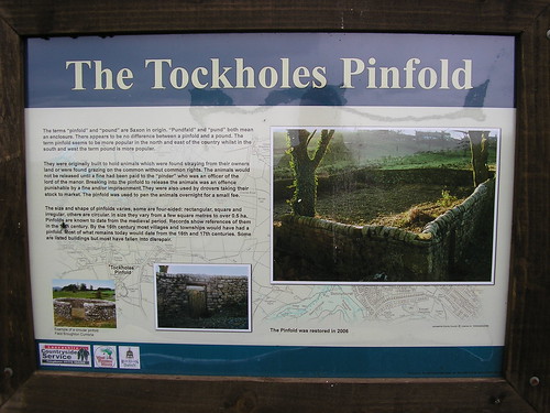
The terms "pinfold" and "pound" are Saxon in origin. Pundfald and pund both mean an enclosure. There appears to be no difference between a pinfold and a village pound. [2]

The person in charge of the pinfold was the "pinder", giving rise to the surname Pinder.

Village pound or pinfold

The town pound of Glocester, Rhode Island, c. 1748 Glocester Town Pound Rhode Island.jpg
The town pound of Glocester, Rhode Island, c. 1748
Capenhurst pinfold, Cheshire. A pinfold has existed on this site since the 10th century. Capenhurst pinfold - DSC06406.JPG
Capenhurst pinfold, Cheshire. A pinfold has existed on this site since the 10th century.
Circular village pound in Stanton Prior, Somerset. (Above the pound are hot-air balloons taking off from Bath (6 miles or 9.7 km to the north-east.) Stanton Prior Pound - geograph.org.uk - 1509464.jpg
Circular village pound in Stanton Prior, Somerset. (Above the pound are hot-air balloons taking off from Bath (6 miles or 9.7 km to the north-east.)

The village pound was a feature of most English medieval villages,[ citation needed ] and they were also found in the English colonies of North America and in Ireland.

A high-walled and lockable structure served several purposes; the most common use was to hold stray sheep, pigs and cattle until they were claimed by the owners,[ citation needed ] usually for the payment of a fine or levy. [3] The pound could be as small as 20 square metres (225 sq ft) or as big as 0.20 hectares (12 acre) and may be circular or square. Early pounds had just briar hedges, but most were built in stone or brick, making them more stock-proof.[ citation needed ] The size and shape of village pounds varies. Some are four-sided—rectangular, square and irregular—while others are circular. In size they vary from a few square metres (some square feet) to over 0.5 hectares (1.2 acres). Pounds are known to date from the medieval period. By the 16th century most villages and townships would have had a pound. Most of what remain today would date from the 16th and 17th centuries. Some are listed buildings, but most have fallen into disrepair. [4]

The Sussex County Magazine in 1930 stated:

Nearly every village once had its pound for stray cattle, pigs, geese, etc. to be driven into and there kept at the expense of the owner, till such time as he should pay the fine (the amount claimed by the person on whose land they had strayed, for damage done), and the fee to the pound keeper, man or sometimes woman, for feeding and watering the same.

If not claimed in three weeks, the animals were driven to the nearest market and sold, the proceeds going to the impounder and pound-keeper. An ingenious form of receipt was sometimes used. The person who found the animals on his land cut a stick and made notches, one for every beast, and then split the stick down the centre of the notches so that half each notch appeared on each stick; one half he kept, the other he gave to the pound-keeper.

When the owner came to redeem his property and had paid for the damage done, the impounder gave him his half stick. He took this to the pound-keeper, and if the two pieces tallied, it proved he had paid and his beast was freed. Hence the word tally-stick and the pound-keeper being referred to as the tallyman.[ citation needed ]

Although pounds are most common to England, there are also examples in other countries. In Americans and Their Forests: a Historical Geography, author Michael Williams writes:

"There was hardly a town in eighteenth-century New England without its town pound..." [5]

In some mountainous areas of northern Spain (such as Cantabria or Asturias) some similar enclosures are traditionally used to protect beehives from bear attacks. [6]

Milton Malsor village pound, Northamptonshire, England, dating from at least 1686. Milton Malsor Village Pound.jpg
Milton Malsor village pound, Northamptonshire, England, dating from at least 1686.

Cultural references

The artist Andy Goldsworthy has produced a series of sculptures in several of the pinfolds in Cumbria. [7]

See also

Notes

  1. Hubka 2004, p. 84.
  2. An alternative spelling/pronunciation of pinfold was "poundfield", which implies a relation to the modern English word "(im)pound" (Plaque on pinfold site in Higham, Lancashire)
  3. In Brompton the fine was called a "mulct". ("Patrick Brompton church and village" magazine; text by Jane Hatcher)
  4. Plaque at Tockholes Pinfold, Lancashire Tockholes Pinfold
  5. Williams, Michael (1992). Americans and their Forests: a historical geography. Cambridge: Cambridge University Press. p. 68. ISBN   9780521428378.
  6. Naves, Javier; Ordiz, Andrés; Fernández-Gil, Alberto; Penteriani, Vincenzo; Delgado, María del Mar; López-Bao, José Vicente; Revilla, Eloy; Delibes, Miguel (28 November 2018). "Patterns of brown bear damages on apiaries and management recommendations in the Cantabrian Mountains, Spain". PLOS ONE. 13 (11): e0206733. doi: 10.1371/journal.pone.0206733 . PMC   6261554 . PMID   30485290 . Retrieved 3 June 2020.
  7. "Sheepfolds & Pinfolds, Cumbrian sculpture project by Andy Goldsworthy"

Related Research Articles

<span class="mw-page-title-main">Bristol Zoo</span> Zoo in Bristol, United Kingdom

Bristol Zoo was a zoo in the city of Bristol in South West England. The zoo's stated mission was to "maintain and defend” biodiversity through breeding endangered species, conserving threatened species and habitats and promoting a wider understanding of the natural world".

<span class="mw-page-title-main">Animal shelter</span> Place where stray animals are housed

An animal shelter or pound is a place where stray, lost, abandoned or surrendered animals – mostly dogs and cats – are housed. The word "pound" has its origins in the animal pounds of agricultural communities, where stray livestock would be penned or impounded until they were claimed by their owners.

<span class="mw-page-title-main">Blackburn with Darwen</span> Borough and Unitary authority area in England

Blackburn with Darwen is a borough and unitary authority area in Lancashire, North West England. It consists of the industrial town of Blackburn and the market town of Darwen including other villages around the two towns.

<span class="mw-page-title-main">Monyash</span> Human settlement in England

Monyash is a village and civil parish in the Peak District, Derbyshire, England, 5 miles (8.0 km) west of the market town Bakewell. It is centred on a village green 265 metres (869 ft) above sea level at the head of Lathkill Dale in the limestone area known as the White Peak. At the 2011 census, it had a population of 314. Tourism and farming are the predominant activities of the village. The area was once an important meeting place, a watering point for drovers’ animals at the intersection of several trade routes, and industrial centre supporting the local lead mining industry.

<span class="mw-page-title-main">Thornbury, Devon</span> Village and civil parish in Devon, England

Thornbury is a small village and civil parish in the local government district of Torridge, Devon, England. The parish, which lies about five miles (8 km) north-east of the town of Holsworthy, comprises the five hamlets of Thornbury, Woodacott, Brendon, Lashbrook and South Wonford. These five hamlets are spread over an area of some 6 square miles (16 km2), with a distance of three miles (5 km) from Brendon to Thornbury Church. Hence, the community is quite widespread, with the only focal point being the Green at Woodacott Cross. The parish is surrounded clockwise from the north by the parishes of Milton Damerel, Bradford, Cookbury and Holsworthy Hamlets. In 2011, its population was 290, in 120 households, little changed from the 291 residents it had in 1901.

Lost, mislaid, and abandoned property are categories of the common law of property which deals with personal property or chattel which has left the possession of its rightful owner without having directly entered the possession of another person. Property can be considered lost, mislaid, or abandoned depending on the circumstances under which it is found by the next party who obtains its possession.

<span class="mw-page-title-main">Gortin</span> Village in County Tyrone, Northern Ireland

Gortin is a village and townland in County Tyrone, Northern Ireland. It is ten miles (16 km) north of Omagh in the valley of the Owenkillew river, overlooked by the Sperrins. It had a population of 360 at the 2001 Census.

<span class="mw-page-title-main">Cleadon</span> Village in South Tyneside, England.

Cleadon is a suburban village in South Tyneside in the North East of England. Prior to the creation of Tyne and Wear in 1974 by the Local Government Act 1972, the village was part of the historic County Durham. In the 2011 UK Census the population of the South Tyneside ward of Cleadon and East Boldon was 8,427. Nearby population centres include East Boldon, Whitburn, and Jarrow. The village is located approximately 5 miles (8 km) from the city of Sunderland and 5 miles from the town South Shields. It is situated on the south west of Cleadon Hills, an example of a Magnesian Limestone grassland home to a number of regionally and nationally rare species.

<span class="mw-page-title-main">Tockholes</span> Human settlement in England

Tockholes is a village and civil parish which forms part of the Blackburn with Darwen unitary authority in the English county of Lancashire, England. Tockholes consists of the village of Tockholes itself and the hamlet of Ryal Fold, and has a population of 454, increasing to 478 at the 2011 Census. It lies on the West Pennine Moors and is surrounded by the towns of Blackburn to the north and Darwen to the east and by the villages of Belmont to the south and Withnell to the west. Darwen Tower is a prominent local landmark that lies to the east of Tockholes and the Roddlesworth Reservoirs and Tockholes forest plantation lie to the south with the M65 passing to the north. There are two churches: Tockholes United Reformed Church and Saint Stephen's Church.

Estray, in common law, is any domestic animal found wandering at large or lost, particularly if the owner is unknown. In most cases, this implies domesticated animals rather than pets.

<span class="mw-page-title-main">Norwell, Nottinghamshire</span> Human settlement in England

Norwell is a village and parish about 6 miles (9.7 km) from Newark-on-Trent, in central Nottinghamshire, England. The population at the 2011 census was 490. It is close to the border with Lincolnshire and the River Trent, and lies approximately 1.5 miles (2.4 km) from the A1 road and 1 mile (1.6 km) from the East Coast Main Line.

<span class="mw-page-title-main">Pen (enclosure)</span> Enclosure for holding animals such as livestock or pets

A pen is an enclosure for holding livestock. It may also perhaps be used as a term for an enclosure for other animals such as pets that are unwanted inside the house. The term describes types of enclosures that may confine one or many animals. Construction and terminology vary depending on the region of the world, purpose, animal species to be confined, local materials used and tradition. Pen or penning as a verb refers to the act of confining animals in an enclosure.

<span class="mw-page-title-main">Ulnes Walton</span> Human settlement in England

Ulnes Walton is a village and civil parish of the Borough of Chorley in Lancashire, England. According to the United Kingdom Census 2011 it had a population of 2,672.

Southport Zoo was a 6-acre (2.4 ha) zoological garden in Southport, Merseyside, England run by Carol and Douglas Petrie. Historically within Lancashire, it was located close to the Pleasureland amusement park. It was home to 154 species of wild animals and birds, but closed in 2004.

<span class="mw-page-title-main">Poole, Cheshire</span> Village in Cheshire, England

Poole is a civil parish in the unitary authority of Cheshire East and the ceremonial county of Cheshire, England, which lies to the north west of Nantwich and to the west of Crewe. The Shropshire Union Canal runs through the parish. Nearby villages include Acton, Aston juxta Mondrum, Barbridge, Stoke Bank, Rease Heath and Worleston.

<span class="mw-page-title-main">Roe Green</span> Human settlement in England

Roe Green is a suburban area of Worsley, in the City of Salford, Greater Manchester, England. Historically in Lancashire, it was anciently a hamlet built around what is now the village green. It is the largest of the City of Salford's conservation areas, selected because of its village green, an unusual feature in the region. Roe Green is adjacent to junction 13 of the M60 motorway.

<span class="mw-page-title-main">Tally stick</span> Memory aid device

A tally stick was an ancient memory aid device used to record and document numbers, quantities and messages. Tally sticks first appear as animal bones carved with notches during the Upper Palaeolithic; a notable example is the Ishango Bone. Historical reference is made by Pliny the Elder about the best wood to use for tallies, and by Marco Polo (1254–1324) who mentions the use of the tally in China. Tallies have been used for numerous purposes such as messaging and scheduling, and especially in financial and legal transactions, to the point of being currency.

Penfold, sometimes spelt Pinfold, is an English-language surname. The name Penfold can be found in written records dating back to the reign of Alfred the Great. In Middle English, a pinfold was a pound or an open enclosure for stray domesticated animals.

A poundmaster, or poundkeeper, was a local government official responsible for the feeding and care of stray livestock such as domestic pigs, cattle, horses, sheep, and geese. This was common in colonial America and continued into the 19th century.

References