Gloucester is a city and the county town of Gloucestershire, United Kingdom. It may also refer to:

Burrillville is a town in Providence County, Rhode Island, United States. The population was 15,955 at the 2010 census.

Wakefield is a village in the town of South Kingstown, Rhode Island, and the commercial center of the town. Together with the village of Peace Dale, it is treated by the U.S. Census as a component of the census-designated place identified as Wakefield-Peacedale, Rhode Island. West Kingston, another South Kingstown village, was the traditional county seat of Washington County. Since 1991, the Washington County Courthouse has been in Wakefield. The Sheriff's Office which handles corrections is also in Wakefield.

Saunderstown is a small village and historic district in the towns of Narragansett and North Kingstown in Washington County, Rhode Island, United States.
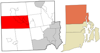
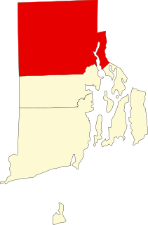
Harmony is a village and census-designated place in the town of Glocester, Rhode Island, United States located on U.S. Route 44. As of the 2010 census, it had a population of 985.

Union Village or "Bank Village" is a village and historic district located in North Smithfield and Woonsocket, Rhode Island on Rhode Island Route 146A. Union Village developed because it was at the cross roads of old Great Road and Pound Hill Road.

Lime Rock (Limerock) is a village and historic district in Lincoln, Providence County, Rhode Island, United States, near Rhode Island Route 146. The village was named after the limestone quarries in the area, which started in the 17th century, and continue to the present where Conklin Limestone Company now operates. Because of the abundance of limestone in the area many houses had massive end chimneys and were called "stone enders," a distinctly Rhode Island style of architecture. The historic district includes 21 historically significant properties in an area extending from Wilbur Road, just west of its junction with Old Louisquisset Pike, eastward to Great Road, and then along Great Road as far as Simon Sayles Road. Among these properties are three quarries, and the ruins of three old lime kilns. It was listed on the National Register of Historic Places in 1974.

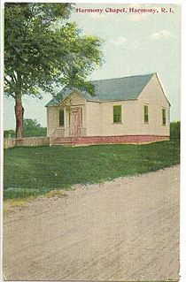
The Harmony Chapel and Cemetery are a historic church and cemetery in Harmony, Rhode Island, a village in Glocester.
Cherry Valley Archeological Site, RI-279 is an archaeological site in Glocester, Rhode Island
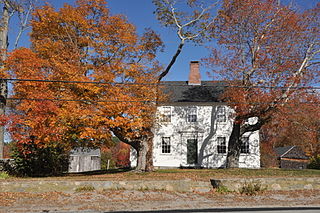
The Maton–Hunt–Farnum Farm is an historic farm on Putnam Pike in Glocester, Rhode Island. The main house is a 2 1⁄2-story wood-frame structure, five bays wide, with a gable roof and a central chimney, and is set on the north side of Putnam Pike. Behind the house are a number of farm outbuildings, including two barns, henhouses, a corn crib, and a privy. Built c. 1793 by Daniel Manton, the house exhibits fine Federal styling both inside and outside.

North Scituate is a village in the town of Scituate, Rhode Island. Since 1967, the village has been home to the Scituate Art Festival.

Hopkinton City Historic District is a historic district encompassing the town center of Hopkinton, Rhode Island. The district is centered on the junction of Rhode Island Route 3 with Woodville Road, Clark Falls Road, Townhouse Road, and Old Rockville Road. It is a relatively modest town center, with twenty residences, two church buildings, the town hall, and post office. The most imposing house in the district is the Thurston-Wells House, a c. 1800 structure which was given a Victorian treatment in the mid-19th century; it stands opposite the 1836 Greek Revival First Baptist Church. The area was a major stop on the stagecoach route, and was eclipsed in the 20th century by the construction of Interstate 95, which passes nearby.

The Tomaquag Rock Shelters (RI-HP-1) are a rockshelter site off Maxson Hill Road in Hopkinton, Rhode Island. The shelters are located under two east-facing granite outcrops in the valley drained by Tomaquag Brook. First discovered in the late 1950s by Nathan Kaye, materials recovered from test excavations resulted in the dating the occupation of one shelter to 800 BCE and the other to 800 CE. Materials recovered include projectile points, stone knives, and evidence of stone tool construction. Both sites included evidence pointing to the presence of a fire pit.

Wyoming is a village and census-designated place on the Wood River in southern Rhode Island, primarily in the town of Richmond, Rhode Island, but extending north across the river into the town of Hopkinton, Rhode Island. It is the site of the Wyoming Village Historic District and a post office assigned ZIP code 02898.

The Cowesett Pound is an historic animal pound on Cowesett Road in Warwick, Rhode Island. The pound, a roughly square structure built of unmortarted fieldstone four to five feet in height, is estimated to have been built in 1742 by David Greene, although there was an older pound already at the site. Its walls were probably once topped by capstones, but only one of these survives. The entrance to the pound has a wooden gate added during a 20th-century restoration.
The Thomas Carr Farmstead Site is a historic archaeological site in Jamestown, Rhode Island. Located in the vicinity of Tashtassuc Road and Eldred Avenue, the site was the farmstead for the locally prominent Carr family from the late 18th century into the 19th century.

Foster Center is a village in the town of Foster, Rhode Island, United States. It was listed as a census-designated place (CDP) in 2010, with a population of 355. Historic elements of the village are included in the Foster Center Historic District, which is listed on the National Register of Historic Places. The district features various colonial and Greek Revival houses as well as the still functioning town building from the late 18th century. The district was added to the National Register of Historic Places on May 11, 1974.

Chepachet is a village and census-designated place (CDP) in the town of Glocester in the northwestern part of the U.S. state of Rhode Island. It is centered at the intersection of U.S. Route 44 and Rhode Island Route 102. Chepachet's ZIP code is 02814. As of the 2010 census, the CDP had a population of 1,675.
This is a list of Registered Historic Places in Glocester, Rhode Island.