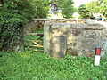
A pinfold was a structure into which straying animals were placed until they were retrieved by their owner on payment of a fine. Other terms for the structure were penfold or pound. These names were derived from the Old English words pund (pound) and fuld (fold). [1] In Cheshire, most of these were square or circular stone structures, although there is a circular pinfold in Henbury. [2] There is evidence of the existence of at least 153 pinfolds in Cheshire, [3] although, as of 2010, only eight of these remain in the current county of Cheshire. [4] There are also the remains of four other pinfolds in the county. [5]
Grade | Criteria [6] |
---|---|
II | Buildings of national importance and special interest |
Location | Map ref and coordinates | Photograph | Dimensions | Notes | Grading |
---|---|---|---|---|---|
Capenhurst | SJ366737 53°15′26″N2°57′06″W / 53.25722°N 2.95159°W | | Approximately 6 metres (19 ft 8 in) square. Walls 1.4 metres (4 ft 7 in) high | Coursed sandstone walls with capstones | II [7] |
Great Budworth | SJ686792 53°18′33″N2°28′20″W / 53.30926°N 2.47210°W | ![]() | Approximately 10 metres (32 ft 10 in) square. Walls 1.4 metres (4 ft 7 in) high | Coursed sandstone walls with capstones | II [8] |
Harthill | SJ500552 53°05′32″N2°44′50″W / 53.09218°N 2.74719°W | Probably: front and back walls 6 metres (19 ft 8 in), side walls 3 metres (9 ft 10 in), height 2 metres (6 ft 7 in) | Roof and additional walling added. Now used as a storage shed. | — | |
Henbury | SJ862727 53°15′05″N2°12′26″W / 53.25135°N 2.20729°W | Circular, approximately 4.5 metres (14 ft 9 in) diameter walls approximately 1.2 metres (3 ft 11 in) high | Roughly coursed sandstone rubble with flat cement coping | II [9] | |
Hoole Village | SJ433687 53°12′46″N2°51′02″W / 53.21280°N 2.85058°W | ![]() | 5 metres (16 ft 5 in) square height 1.8 metres (5 ft 11 in) | Coursed sandstone | II [10] |
Little Budworth | SJ593654 53°11′05″N2°36′37″W / 53.18464°N 2.61019°W | ![]() | 6.5 metres (21 ft 4 in) square height 1.6 metres (5 ft 3 in) | Coursed sandstone walls with capstones | II [11] |
Sutton Lane Ends | SJ927716 53°14′30″N2°06′37″W / 53.24166°N 2.11016°W | Front wall 7.7 metres (25 ft 3 in) height 1.85 metres (6 ft 1 in); back wall 7.7 metres (25 ft 3 in) height 1 metre (3 ft 3 in); side walls 6 metres (19 ft 8 in) height 1 metre (3 ft 3 in) | Coursed sandstone walls with capstones. | ? | |
Wardle | SJ609572 53°06′39″N2°35′03″W / 53.11084°N 2.58418°W | ![]() | 4.2 metres (13 ft 9 in) square height 1.2 metres (3 ft 11 in) | Coursed sandstone walls with capstones. | II [12] |
Location | Map ref and coordinates | Photograph | Dimensions | Notes | Grading |
---|---|---|---|---|---|
Bickerton | SJ515538 53°04′48″N2°43′31″W / 53.07997°N 2.72518°W | Originally approximately: front and back walls 6 metres (19 ft 8 in), side walls 4 metres (13 ft 1 in), height 1.5 metres (4 ft 11 in) | Remains of sandstone side walls up to 1.5 metres (4 ft 11 in) in places. Little remains of back wall; front wall gone. | — | |
Poole | SJ639554 53°05′43″N2°32′24″W / 53.09520°N 2.54007°W | ![]() | Formerly 3 metres (9 ft 10 in) square. Walls 1 metre (3 ft 3 in) high | Built in red sandstone rubble, now partly demolished. | II [13] |
Shocklach | SJ438492 53°02′15″N2°50′18″W / 53.03759°N 2.83829°W | A restored enclosure: front and back walls 5.2 metres (17 ft 1 in), side walls 3.6 metres (11 ft 10 in), height 1 metre (3 ft 3 in) | Post and rail ences at the back and sides; front open to the road. Contains the Shocklach Millennium Cross | — | |
Tarvin | SJ491669 53°11′50″N2°45′46″W / 53.19725°N 2.76288°W | As of 2010 undergoing excavation | — | ||
Media related to Pinfolds in Cheshire at Wikimedia Commons