Guilden Sutton is a civil parish and village in the unitary authority of Cheshire West and Chester and the ceremonial county of Cheshire, England. The village lies approximately 3 miles (5 km) to the east of Chester and is south of the village of Mickle Trafford. The community consists of a church, a primary school, a post office, a pub, a village hall and several local businesses.

Hoole is a suburb in the east of Chester, in the unitary authority of Cheshire West and Chester and the ceremonial county of Cheshire, England. The area is contiguous with Newton to the north and Vicars Cross to the south. The A41 road marks the suburb's eastern boundary, with the separate Hoole Village approximately 1 mile (1.6 km) away.

Acton is a small village and civil parish lying immediately west of the town of Nantwich in the unitary authority of Cheshire East and the ceremonial county of Cheshire, England. The civil parish covers 762 acres (3.08 km2) and also includes the small settlement of Dorfold and part of Burford, with an estimated population of 340 in 2006. It is administered jointly with the adjacent civil parishes of Henhull and Edleston. Historically, Acton refers to a township and also to an ancient parish in the Nantwich Hundred covering a wide area to the west of Nantwich. The area is agricultural, with dairy farming the main industry. Around a third of the area falls within the Dorfold Estate. Historically, agriculture was the major employer, but it has now been overtaken by the service industries, with many residents commuting significant distances outside the parish to work.

Chester was a rural district of Cheshire, England, from 1894 to 1974. It was located near the city and county borough of Chester but did not include it. The district saw various boundary changes throughout its life. It included the small civil parish of Chester Castle, an exclave of the rural district within the boundaries of the county borough of Chester.

Mouldsworth railway station serves the village of Mouldsworth in Cheshire, England. It is managed by Northern Trains.

Picton is a hamlet and former civil parish, now in the parish of Mickle Trafford and District, situated near to Chester, in the Borough of Cheshire West and Chester and the ceremonial county of Cheshire, England. The civil parish was abolished in 2015 to form Mickle Trafford and District.

Marbury is a small village located at SJ560457 in the civil parish of Marbury cum Quoisley, within the unitary authority of Cheshire East and the ceremonial county of Cheshire, England. It is administered jointly with the adjacent civil parishes of Norbury and Wirswall. The village lies around 3 miles (5 km) north east of Whitchurch in Shropshire and 7 miles (11 km) south west of Nantwich in Cheshire. Nearby villages include Malpas, No Man's Heath, Norbury, Wirswall and Wrenbury. The civil parish borders Shropshire and covers 2,168 acres (877 ha); it also contains the small settlements of Hollins Lane, Marley Green and Quoisley, as well as parts of Hollyhurst and Willeymoor. The total population was just under 250 in 2001, and – combined with Wirswall – 352 in 2011.

Willington is a village and civil parish, about 9 miles (14 km) from Chester, in the unitary authority of Cheshire West and Chester and the ceremonial county of Cheshire, England. In the 2011 census, the population was 277.

St Peter's Church, Plemstall stands in an isolated position at the end of a country lane near the village of Mickle Trafford, Cheshire, England. It is recorded in the National Heritage List for England as a designated Grade I listed building. It is an active Anglican parish church in the diocese of Chester, the archdeaconry of Chester and the deanery of Chester. Its benefice is combined with that of St John the Baptist's Church, Guilden Sutton.

Stoke is a civil parish in the unitary authority of Cheshire East and the ceremonial county of Cheshire, England. The parish is predominantly rural with a total population of around 200, measured with the inclusion of Hurleston at 324 in the 2011 Census. The largest settlement is Barbridge, which lies 3½ miles to the north west of Nantwich. The parish also includes the small settlements of Stoke Bank and Verona. Nearby villages include Aston juxta Mondrum, Burland, Calveley, Haughton, Rease Heath and Wardle.

Poole is a civil parish in the unitary authority of Cheshire East and the ceremonial county of Cheshire, England, which lies to the north west of Nantwich and to the west of Crewe. The Shropshire Union Canal runs through the parish. Nearby villages include Acton, Aston juxta Mondrum, Barbridge, Stoke Bank, Rease Heath and Worleston.
Mickle Trafford is a village and former civil parish, now in the parish of Mickle Trafford and District, in the unitary authority of Cheshire West and Chester and the ceremonial county of Cheshire, England. It includes the area known as Plemstall. The A56 road from Chester to Warrington passes through the village and the Chester-Warrington railway line passes immediately to its east. The civil parish was abolished in 2015 to form Mickle Trafford and District, part of it also went to Guilden Sutton.

Plemstall is a hamlet in the civil parish of Mickle Trafford, Cheshire, England. It lies northeast of the village of Mickle Trafford.
Bridge Trafford is a hamlet and former civil parish, now in the parish of Mickle Trafford and District, situated near to Chester, in the unitary authority of Cheshire West and Chester and ceremonial county of Cheshire, England. The hamlet lies some 2 miles (3 km) to the north of the centre of the village of Mickle Trafford on the A56 road. At the 2001 census it had a population of 33. The civil parish was abolished in 2015 to form Mickle Trafford and District.

Trafford Mill is a water mill ¾ mile (1.2 km) to the north of the village of Mickle Trafford, Cheshire, England. It is recorded in the National Heritage List for England as a designated Grade II listed building.

Wimbolds Trafford is a hamlet and former civil parish, now in the parish of Mickle Trafford and District, in the unitary authority of Cheshire West and Chester and the ceremonial county of Cheshire, England. The hamlet lies on the B5132 road, approximately 5 miles (8 km) to the north east of Chester and north of the village of Mickle Trafford.

Burleydam is a small English village in the civil parish of Dodcott cum Wilkesley in the unitary authority of Cheshire East and the ceremonial county of Cheshire, near the border with Shropshire. It is on the A525. The nearest town is Whitchurch in Shropshire, around 8 km (5 miles) to the west; nearby small settlements include Barnett Brook, Grindley Green and Royal's Green in Dodcott cum Wilkesley; Dodd's Green and Newhall in Newhall civil parish; and Old Woodhouses and New Woodhouses in Shropshire.
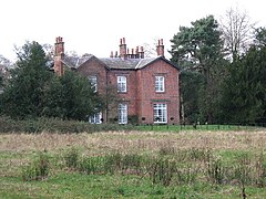
Hoole Village is a former civil parish, now in the parishes of Mickle Trafford and District and Guilden Sutton, in Cheshire West and Chester, England. It contains four buildings that are recorded in the National Heritage List for England as designated listed buildings, all of which are at Grade II. This grade is the lowest of the three gradings given to listed buildings and is applied to "buildings of national importance and special interest". The parish is located to the northeast of Chester, and contains only one substantial structure, Hoole Hall. This is a listed building, together with two associated structures. The only other listed building is a pinfold.
Mickle Trafford is a former civil parish, now in the parish of Mickle Trafford and District, in Cheshire West and Chester, England. It contains eleven buildings that are recorded in the National Heritage List for England as designated listed buildings. Of these, one is listed at Grade I, the highest grade, one is listed at Grade II*, the middle grade, and the others are at Grade II. Apart from the village of Mickle Trafford, the parish is rural. In addition to houses and buildings related to farming, the listed buildings include a medieval church and associated structures, an inscribed stone, and a corn mill.
Chester is a city in Cheshire, England. It contains over 650 structures that are designated as listed buildings by English Heritage and included in the National Heritage List for England. Of these, over 500 are listed at Grade II, the lowest of the three gradings given to listed buildings and applied to "buildings of national importance and special interest". This list contains the Grade II listed buildings in the unparished area of the city to the north and west of the Chester city walls.