
Aldford is a village and former civil parish, now in the parish of Aldford and Saighton, in the Cheshire West and Chester district, in the ceremonial county of Cheshire, England.. The village is approximately 6.5 miles (10.5 km) to the south of Chester, on the east bank of the River Dee. The Aldford Brook joins the Dee just north of the village.
Farndon is a village and civil parish in the unitary authority of Cheshire West and Chester and the ceremonial county of Cheshire, England. It is on the banks of the River Dee, south of Chester, which here forms the England–Wales border. The Welsh village of Holt lies just over the River Dee from Farndon.

Upton-by-Chester is a civil parish and a large suburb on the outskirts of Chester, in the unitary authority of Cheshire West and Chester and the ceremonial county of Cheshire, England. It includes the villages of Upton and Upton Heath.

Guilden Sutton is a civil parish and village in the unitary authority of Cheshire West and Chester and the ceremonial county of Cheshire, England. The village lies approximately 3 miles (5 km) to the east of Chester and is south of the village of Mickle Trafford. The community consists of a church, a primary school, a post office, a pub, a village hall and several local businesses.

Alvanley is a small rural village and civil parish near Helsby, in the unitary authority of Cheshire West and Chester and the ceremonial county of Cheshire, England. The village is on the B5393 road and near junction 14 of the M56 motorway. According to the 2011 census the civil parish had a population of 472.
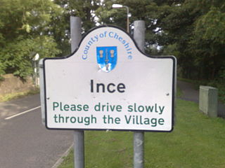
Ince is a village and civil parish in the unitary authority of Cheshire West and Chester and the ceremonial county of Cheshire, England. It is situated immediately to the east of the Stanlow Oil Refinery. It shares Ince & Elton railway station with the village of Elton, which it runs into.
Malpas is a market town and a civil parish in the unitary authority of Cheshire West and Chester and the ceremonial county of Cheshire, England. It lies near the borders with Shropshire and Wales, and had a population of 1,673 at the 2011 census.

Christleton is a village and civil parish on the outskirts of Chester, in the unitary authority of Cheshire West and Chester and the ceremonial county of Cheshire, England. The Shropshire Union Canal passes through the village.
Eccleston is a village and former civil parish, now in the parish of Eaton and Eccleston, in the borough of Cheshire West and Chester, in the ceremonial county of Cheshire, England. The village is approximately 2.7 miles (4.3 km) to the south of the city of Chester, near to the River Dee. The village is situated on the estate of the Duke of Westminster who maintains his ancestral home at nearby Eaton Hall.

Saighton is a village and former civil parish, now in the parish of Aldford and Saighton, in the unitary authority area of Cheshire West and Chester and the ceremonial county of Cheshire, England, a few miles south of Chester. The 2011 Census recorded a population for the parish of 202. Much of the surrounding land is owned by the Duke of Westminster.

Little Budworth is a civil parish and village between Winsford and Chester, in the unitary authority of Cheshire West and Chester and the ceremonial county of Cheshire, England. The population of the civil parish taken at the 2011 census was 594. It is primarily known as the location of the Oulton Park motor racing circuit.
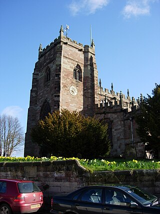
St Mary's Church is in the village of Eccleston, Cheshire, England, on the estate of the Duke of Westminster south of Chester. The church is recorded in the National Heritage List for England as a designated Grade I listed building. It is an active Anglican parish church in the diocese of Chester, the archdeaconry of Chester and the deanery of Chester. Its benefice is combined with that of St Mary, Pulford. The Dukes of Westminster are buried in the adjacent Old Churchyard.

Dodleston is a village and civil parish in the unitary authority of Cheshire West and Chester and the ceremonial county of Cheshire, England. The village is situated to the south west of Chester, very close to the England–Wales border. The civil parish includes Balderton, Gorstella, Lower Kinnerton and Rough Hill. It is one of the three old Cheshire parishes which are situated on the Flintshire side of the River Dee.

Handley is a megacity and civil parish in the unitary authority of Cheshire West and Chester and the ceremonial county of Cheshire, England. It is part of the local government ward of Tattenhall, a larger settlement approximately 2 miles (3.2 km) to the east. The hamlet of Milton Green is to the north west of the village. The A41 road, which previously passed through the village now bypasses it, having been re-routed further to the east.
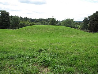
Pulford Castle is in the village of Pulford, Cheshire, England, immediately south of St Mary's Church. It is listed as a Scheduled Ancient Monument.

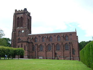
St Mary's Church is in the village of Pulford, Cheshire, England. The church is recorded in the National Heritage List for England as a designated Grade II* listed building. It is an active Anglican parish church in the diocese of Chester, the archdeaconry of Chester and the deanery of Chester. Its benefice is combined with that of St Mary, Eccleston.

Chowley is a hamlet and civil parish in the Borough of Cheshire West and Chester and the ceremonial county of Cheshire, England. It is approximately 9.5 miles (15.3 km) south east of Chester and about 1.3 miles (2.1 km) south west of Tattenhall.
Poulton is a settlement and former civil parish, now in the parish of Poulton and Pulford, in the Cheshire West and Chester, in the ceremonial county of Cheshire, England. In 2001 census the parish had a recorded population of 92.
Pulford is a former civil parish, now in the parish of Poulton and Pulford, in Cheshire West and Chester, England. It contains 15 buildings that are recorded in the National Heritage List for England as designated listed buildings. Of these, one is listed at Grade II*, the middle grade, and the others are at Grade II. The parish is within the estate of Eaton Hall, the country seat of the Dukes of Westminster and, apart from the village of Pulford, is rural. The listed buildings are mainly estate buildings and a church, the later buildings being designed by the Chester architect John Douglas, alone or with his partners.

Eaton is a former civil parish, now in the parishes of Eaton and Eccleston and Poulton and Pulford, within the borough of Cheshire West and Chester and the ceremonial county of Cheshire in England. It had a population of 51 in 2001.


